
Video of an active breakout of the Pu‘u ‘Ō‘ō episode 61G lava flow. This breakout is below the pali on the eastern margin of the flow. pāhoehoe lava is flowing out from the base of an inflated tumulus, and has a characteristic blue tint to its surface crust (compared to the color of solidified lava around it).
Images
Images related to natural hazards.
Filter Total Items: 7275

61G Lava Breakout
Video of an active breakout of the Pu‘u ‘Ō‘ō episode 61G lava flow. This breakout is below the pali on the eastern margin of the flow. pāhoehoe lava is flowing out from the base of an inflated tumulus, and has a characteristic blue tint to its surface crust (compared to the color of solidified lava around it).

Mount St. Helens as viewed from the ENE.
Mount St. Helens, as viewed from the East-Northeast. The inside of the crater rim is just visible in the upper right of the mountain.
Mount St. Helens, as viewed from the East-Northeast. The inside of the crater rim is just visible in the upper right of the mountain.


Field survey methods
Photos of survey equipment used during surveys of the Elwha River delta, Washington, from 2010-2017, showing:
Photos of survey equipment used during surveys of the Elwha River delta, Washington, from 2010-2017, showing:

Did aerial bombing stop the 1935 Mauna Loa lava flow?
Did aerial bombing stop the 1935 Mauna Loa lava flow?Aerial view of a bomb detonating on Mauna Loa near the 8500-foot elevation source of the 1935 lava flow on the morning of December 27, 1935. This was one of twenty 600-pound bombs dropped on the lava flow that morning by the Army Bombing Squadron from Luke Field, O‘ahu. Photo by Army Air Corps, 11th Photo Section.

Flooding on a road in Olympic National Park, Washington
Flooding on a road in Olympic National Park, WashingtonFlooding on a road in Olympic National Park, Washington, on November 24, 2017.
Flooding on a road in Olympic National Park, Washington
Flooding on a road in Olympic National Park, WashingtonFlooding on a road in Olympic National Park, Washington, on November 24, 2017.

What do we call new land at Kīlauea's ocean entries?
What do we call new land at Kīlauea's ocean entries?Kīlauea Volcano's Kamokuna lava delta on October 6, 2017. Multiple streams of lava entering the ocean on both sides of the delta created small plumes of laze (lava haze). The visible part of the delta, which is deceptively stable, was built by many small lava flows accumulating on an unstable foundation of unconsolidated volcanic rock fragments. USGS photo by L.

Typical lava lake activity at Kīlauea's summit
Kīlauea Volcano's summit lava lake activity over the past few days has been typical, with intermittent sites of spattering and migration of the crust from north to south (top to bottom of image). This view of the lava lake was captured on the evening of Saturday, November 18.
Kīlauea Volcano's summit lava lake activity over the past few days has been typical, with intermittent sites of spattering and migration of the crust from north to south (top to bottom of image). This view of the lava lake was captured on the evening of Saturday, November 18.

typical spattering in the summit lava lake in Halema‘uma‘u
typical spattering in the summit lava lake in Halema‘uma‘uThis video shows typical spattering in the summit lava lake in Halema‘uma‘u Crater. Spattering is driven by the bursting of large gas bubbles. The surface crust tends to flow into the spattering sites, where the crust is shredded and sinks.

Spattering is common in the summit lava lake, normally at one or mo...
Spattering is common in the summit lava lake, normally at one or mo...Spattering is common in the summit lava lake, normally at one or more sites along the lake margin. A spattering area along the northeast lake margin on Friday, November 17, is shown here. The surface crust tends to flow into the spattering area, where it sinks.

The surface crust on the summit lava lake has many different textur...
The surface crust on the summit lava lake has many different textur...The surface crust on the summit lava lake has many different textures, and these textures can be used to identify where portions of a crustal plate originated. For instance, in this November 20 photo, the long narrow band of striated crust that cuts across the image diagonally originated from the spreading zone in the upper left area of the photo.

Weak flows on Kamokuna delta
Over the past week, the episode 61g Kamokuna lava delta has been partially resurfaced by viscous, spiny pāhoehoe flows (darker in color). Geologists at the ocean entry today (November 17) did not see an active ocean entry, but lava has intermittently entered the ocean over the past few weeks.
Over the past week, the episode 61g Kamokuna lava delta has been partially resurfaced by viscous, spiny pāhoehoe flows (darker in color). Geologists at the ocean entry today (November 17) did not see an active ocean entry, but lava has intermittently entered the ocean over the past few weeks.

Drive along Saddle Road reveals outstanding volcanic geology
Drive along Saddle Road reveals outstanding volcanic geologyTwo nene fly above Pu‘uhuluhulu, a forested Mauna Kea cinder cone surrounded by younger Mauna Loa lava flows (foreground), in the Humu‘ula Saddle on the Island of Hawai‘i. This cone is just one of the outstanding volcanic features that can be seen along Route 200, the Daniel K. Inouye Highway. USGS photo by J. Kauahikaua.

Leading a FEMA training course near Lassen Volcanic National Park
Leading a FEMA training course near Lassen Volcanic National ParkUSGS volcanologist Jessica Ball leads a discussion during a FEMA Volcanic Crisis Awareness course held in Chester, CA in November 2017.
Leading a FEMA training course near Lassen Volcanic National Park
Leading a FEMA training course near Lassen Volcanic National ParkUSGS volcanologist Jessica Ball leads a discussion during a FEMA Volcanic Crisis Awareness course held in Chester, CA in November 2017.

Santa Cruz Main Beach Webcam Snapshot
Snapshot from video camera that sits atop the Dream Inn looks eastward over Main Beach and boardwalk in Santa Cruz, California.
Snapshot from video camera that sits atop the Dream Inn looks eastward over Main Beach and boardwalk in Santa Cruz, California.

Santa Cruz Main Beach
Still-image from video camera atop the Dream Inn looks eastward over Main Beach and boardwalk in Santa Cruz, CA.
Still-image from video camera atop the Dream Inn looks eastward over Main Beach and boardwalk in Santa Cruz, CA.
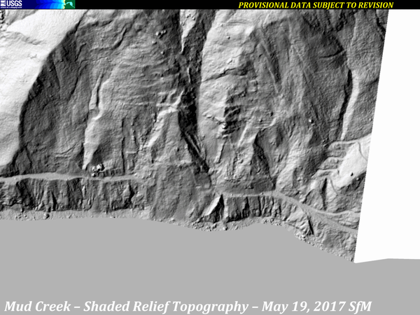
Mud Creek Shaded-Relief Topography, 2010-2017
A series of images from various sources of shaded-relief topography show the progression of the Mud Creek landslide area, from 2010 through October 12, 2017.
Sources:
A series of images from various sources of shaded-relief topography show the progression of the Mud Creek landslide area, from 2010 through October 12, 2017.
Sources:

Threat Rankings of our Nation's geologically young volcanoes
Threat Rankings of our Nation's geologically young volcanoesHualālai (center) and Mauna Loa (left background), two of the four active volcanoes on the Island of Hawai‘i, are ranked as "high threat" and "very high threat" volcanoes, respectively. Kīholo Bay (left foreground) is flanked on the north (left) by a lava flow erupted from Mauna Loa in 1859 and on the south by the Ka‘ūPULEHU flow erupted from Hualālai around 1800.

Previous Evidence of Water on Mars Now Identified as Grainflows
Previous Evidence of Water on Mars Now Identified as GrainflowsThis HiRISE image cutout shows Recurring Slope Lineae in Tivat crater on Mars in enhanced color. The narrow, dark flows descend downhill (towards the upper left). Analysis shows that the flows all end at approximately the same slope, which is similar to the angle of repose for sand.

Feeling crabby
Seafloor photograph of a spider crab, sediment, rocks, taken by the Woods Hole Coastal and Marine Science Center SeaBOSS during a deployment off the R/V Connecticut in Long Island Sound
Seafloor photograph of a spider crab, sediment, rocks, taken by the Woods Hole Coastal and Marine Science Center SeaBOSS during a deployment off the R/V Connecticut in Long Island Sound

Long Island Sound Survey Team
Long Island Sound Survey mapping team. This project is a collaboration of several agencies and institutions including Univ of Connecticut, Univ of New Haven, Connecticut Department of Energy and Environmental Protection, NOAA, LDEO, USGS
Long Island Sound Survey mapping team. This project is a collaboration of several agencies and institutions including Univ of Connecticut, Univ of New Haven, Connecticut Department of Energy and Environmental Protection, NOAA, LDEO, USGS