
Hydrogeophysics Core Technology Team Active
Electromagnetic imaging tools
are used to identify terrestrial groundwater discharge that may be impacted by contaminants.
Water tracing dyes
are injected into streams to guide geophysical measurements and identify contaminant loading.
Long-term fiber-optic temperature sensing arrays
are used to track groundwater discharges to creeks.
About the Research.
The Hydrogeophysics Core Technology Team (CTT) as part of the Environmental Health Program specializes in locating and quantifying exchanges of groundwater and surface water, along with characterizing geologic structure and mapping hydrologic connectivity across varied landscapes.
The Hydrogeophysics CTT conducts applied research and methods development to evaluate the use of emerging hydrogeophysical tools and methods to improve our understanding of hydrologic processes.
“If there is magic on this planet, it is contained in water.” -Loren Eiseley
The Hydrogeophysics CTT harnesses that magic using natural and induced geophysical signals to measure a range of hydrogeologic parameters relevant to the research of Integrated Science Teams.

For example, geophysical methods based on measuring the electrical, thermal, and (or) physical properties of surface water, groundwater, and the shallow subsurface can enable the efficient geolocation and quantification of groundwater and surface-water related processes. Such spatially comprehensive and spatially distributed information can tie point measurements to larger geologic structures and ecological processes impacting flow and transport at local and regional scales. Similar data types collected over time (i.e., time-lapse data) allow researchers to track highly dynamic processes such as the movement of contaminant plumes, soil moisture, and saltwater intrusion. As a result, we are better able to understand and forecast movement of water between groundwater and surface-water bodies and associated changes in water quality and quantity.
The Hydrogeophysics CTT has been a leader in advancing the use of hydrogeophysics to study groundwater/surface-water exchange, groundwater process, and controlling geology for decades via methods and software development and pioneering research. Current efforts continue to foster innovation and development of hydrogeophysical technologies and methodologies to answer important questions related to PFAS and metals fate and transport, HABs, and other pressing EH research goals.
Key Capabilities
Land Surface Geophysical Capabilities
- tTEM (towed transient EM); Minerals IST, Leadville, CO
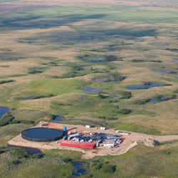
- ERT – electrical resistivity tomography; Williston, ND Energy IST
- EM (GEM, DualEM, TEM); Energy IST, Williston, ND; Minerals IST, Silverton, CO; Minerals IST, Leadville, CO
- Seismic refraction
- MASW – multi-channel analysis of surface wave
- Passive seismic (H/V); PFAS IST, Cape Cod, MA
- GPR – ground penetrating radar
- sNMR; EH Methods Development
Waterborne and Wetland Capabilities
- Vertical temperature profiling of streambed exchange fluxes; EH Methods Development; PFAS IST, Cape Cod, MA; Energy IST, Williston, ND; Minerals IST, Silverton, CO
- Fiber-Optic DTS; PFAS IST, Cape Cod, MA; Minerals IST, Silverton, CO
- TIR – thermal infrared; PFAS IST, Cape Cod, MA; Minerals IST, Silverton, CO; Minerals IST, Leadville, CO
- Air-Water Temperature logging; EH Methods Development; PFAS IST, Cape Cod, MA; Minerals IST, Silverton, CO
Water tracer methods; Minerals IST, Leadville, CO - FloaTEM (towed TEM)
- CRP – continuous resistivity profiling
- EM (GEM); PFAS IST, Cape Cod, MA; Minerals IST, Silverton, CO; Energy IST, Williston, ND
- CSP – continuous seismic
Monitoring Well and Borehole Geophysical Capabilities

- Caliper
- Fluid Temp and Resistivity
- Natural Gamma
- Resistivity, SP, SPR
- EMI – electromagnetic induction
- Magnetic susceptibility
- OTV and ATV imaging
- Camera
- Flowmeters (EM and HeatPulse)
- Dye dilution
- FWS – full waveform sonic
- Spectral Gamma
- Induced polarization
- Non-directional radar
- bNMR – nuclear magnetic resonance (multiple tools); EH Methods Development
Uncrewed Aircraft Capabilities
- Visual Imaging (RGB); Energy IST, Bemidji, MN; PFAS IST, Cape Cod, MA
- TIR; PFAS IST, Cape Cod, MA
- GPR
- Multi-spectral Imaging
† Hypertext links to non-USGS products and services; and the use of trade names, trademarks, company names, or other references to non-USGS products and services are provided for information only and do not constitute endorsement or warranty by the U.S. Geological Survey (USGS), U.S. Department of the Interior, or U.S. Government.
Environmental Health Integrated Science Team Collaborators
-
Energy Integrated Science Team
The Energy Lifecycle Integrated Science Team focuses on the potential for contaminant exposures in the environment that might originate from energy resource activities including, extraction, production, transportation, storage, extraction, waste management and restoration. Perceived health risks to humans and other organisms will be distinguished from actual risks, if any. If actual risks are...Drinking Water and Wastewater Infrastructure Science Team
The team studies toxicants and pathogens in water resources from their sources, through watersheds, aquifers, and infrastructure to human and wildlife exposures. That information is used to develop decision tools that protect human and wildlife health.Per-and Polyfluoroalkyl Substances (PFAS) Integrated Science Team
Increasing scientific and public awareness of the widespread distribution of per- and poly-fluoroalkyl substances (PFAS) in U.S. drinking-water supplies, aquatic and terrestrial ecosystems, wildlife, and humans has raised many public health and resource management questions that U.S. Geological Survey's (USGS) science can inform. The USGS Environmental Health Program's PFAS Integrated Science Team...


Multimedia items related to the Hydrogeophysics Core Technology Team can be found below.

Hot Stream, Cold Stream – Measuring the impact of Groundwater on Stream Temperature
Groundwater that drains to surface water through seeps and springs is generally referred to as “discharge.” Groundwater discharge is a primary component of stream base flow, or streamflow that occurs between storms, periods of snowmelt runoff, and periods of quick soil drainage.
About the Research.
The Hydrogeophysics Core Technology Team (CTT) as part of the Environmental Health Program specializes in locating and quantifying exchanges of groundwater and surface water, along with characterizing geologic structure and mapping hydrologic connectivity across varied landscapes.
The Hydrogeophysics CTT conducts applied research and methods development to evaluate the use of emerging hydrogeophysical tools and methods to improve our understanding of hydrologic processes.
“If there is magic on this planet, it is contained in water.” -Loren Eiseley
The Hydrogeophysics CTT harnesses that magic using natural and induced geophysical signals to measure a range of hydrogeologic parameters relevant to the research of Integrated Science Teams.
For example, geophysical methods based on measuring the electrical, thermal, and (or) physical properties of surface water, groundwater, and the shallow subsurface can enable the efficient geolocation and quantification of groundwater and surface-water related processes. Such spatially comprehensive and spatially distributed information can tie point measurements to larger geologic structures and ecological processes impacting flow and transport at local and regional scales. Similar data types collected over time (i.e., time-lapse data) allow researchers to track highly dynamic processes such as the movement of contaminant plumes, soil moisture, and saltwater intrusion. As a result, we are better able to understand and forecast movement of water between groundwater and surface-water bodies and associated changes in water quality and quantity.
The Hydrogeophysics CTT has been a leader in advancing the use of hydrogeophysics to study groundwater/surface-water exchange, groundwater process, and controlling geology for decades via methods and software development and pioneering research. Current efforts continue to foster innovation and development of hydrogeophysical technologies and methodologies to answer important questions related to PFAS and metals fate and transport, HABs, and other pressing EH research goals.
Key Capabilities
Land Surface Geophysical Capabilities
- tTEM (towed transient EM); Minerals IST, Leadville, CO
- ERT – electrical resistivity tomography; Williston, ND Energy IST
- EM (GEM, DualEM, TEM); Energy IST, Williston, ND; Minerals IST, Silverton, CO; Minerals IST, Leadville, CO
- Seismic refraction
- MASW – multi-channel analysis of surface wave
- Passive seismic (H/V); PFAS IST, Cape Cod, MA
- GPR – ground penetrating radar
- sNMR; EH Methods Development
Waterborne and Wetland Capabilities
- Vertical temperature profiling of streambed exchange fluxes; EH Methods Development; PFAS IST, Cape Cod, MA; Energy IST, Williston, ND; Minerals IST, Silverton, CO
- Fiber-Optic DTS; PFAS IST, Cape Cod, MA; Minerals IST, Silverton, CO
- TIR – thermal infrared; PFAS IST, Cape Cod, MA; Minerals IST, Silverton, CO; Minerals IST, Leadville, CO
- Air-Water Temperature logging; EH Methods Development; PFAS IST, Cape Cod, MA; Minerals IST, Silverton, CO
Water tracer methods; Minerals IST, Leadville, CO - FloaTEM (towed TEM)
- CRP – continuous resistivity profiling
- EM (GEM); PFAS IST, Cape Cod, MA; Minerals IST, Silverton, CO; Energy IST, Williston, ND
- CSP – continuous seismic
Monitoring Well and Borehole Geophysical Capabilities
- Caliper
- Fluid Temp and Resistivity
- Natural Gamma
- Resistivity, SP, SPR
- EMI – electromagnetic induction
- Magnetic susceptibility
- OTV and ATV imaging
- Camera
- Flowmeters (EM and HeatPulse)
- Dye dilution
- FWS – full waveform sonic
- Spectral Gamma
- Induced polarization
- Non-directional radar
- bNMR – nuclear magnetic resonance (multiple tools); EH Methods Development
Uncrewed Aircraft Capabilities
- Visual Imaging (RGB); Energy IST, Bemidji, MN; PFAS IST, Cape Cod, MA
- TIR; PFAS IST, Cape Cod, MA
- GPR
- Multi-spectral Imaging
† Hypertext links to non-USGS products and services; and the use of trade names, trademarks, company names, or other references to non-USGS products and services are provided for information only and do not constitute endorsement or warranty by the U.S. Geological Survey (USGS), U.S. Department of the Interior, or U.S. Government.
Environmental Health Integrated Science Team Collaborators
-
Energy Integrated Science Team
The Energy Lifecycle Integrated Science Team focuses on the potential for contaminant exposures in the environment that might originate from energy resource activities including, extraction, production, transportation, storage, extraction, waste management and restoration. Perceived health risks to humans and other organisms will be distinguished from actual risks, if any. If actual risks are...Drinking Water and Wastewater Infrastructure Science Team
The team studies toxicants and pathogens in water resources from their sources, through watersheds, aquifers, and infrastructure to human and wildlife exposures. That information is used to develop decision tools that protect human and wildlife health.Per-and Polyfluoroalkyl Substances (PFAS) Integrated Science Team
Increasing scientific and public awareness of the widespread distribution of per- and poly-fluoroalkyl substances (PFAS) in U.S. drinking-water supplies, aquatic and terrestrial ecosystems, wildlife, and humans has raised many public health and resource management questions that U.S. Geological Survey's (USGS) science can inform. The USGS Environmental Health Program's PFAS Integrated Science Team...
Multimedia items related to the Hydrogeophysics Core Technology Team can be found below.
Hot Stream, Cold Stream – Measuring the impact of Groundwater on Stream Temperature
Groundwater that drains to surface water through seeps and springs is generally referred to as “discharge.” Groundwater discharge is a primary component of stream base flow, or streamflow that occurs between storms, periods of snowmelt runoff, and periods of quick soil drainage.