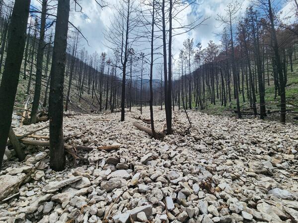
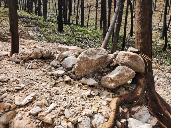
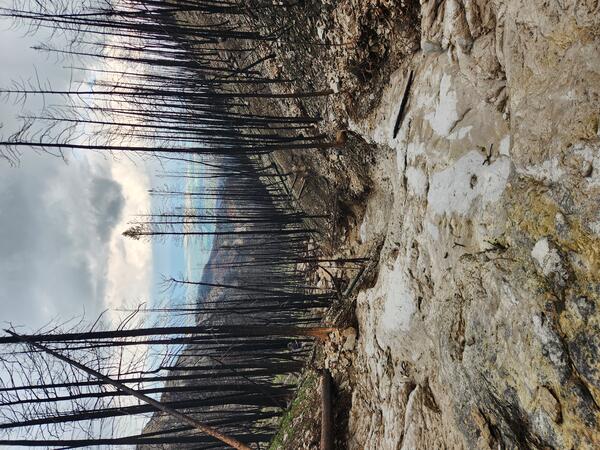
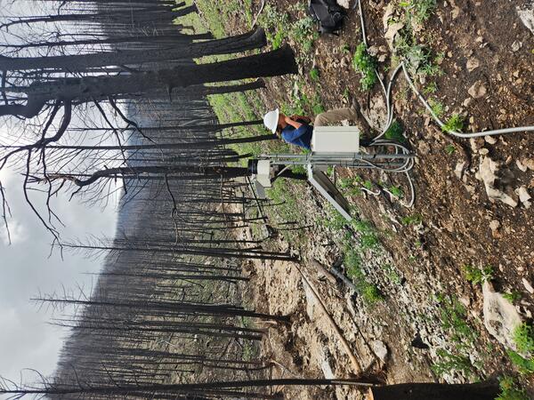
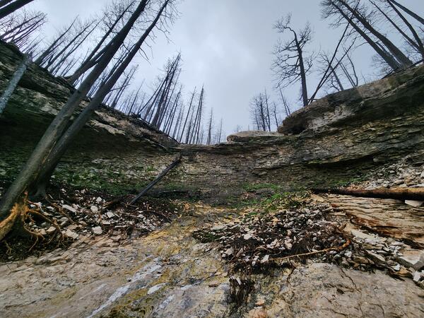
U.S. flag

An official website of the United States government

Images

Browse our photos of landslide research and post-landslide investigations.

Filter Total Items: 259
channel filled with cobbles and small burned with burned trees in channel
Postfire debris-flow deposit in the 2024 Elk Fire burn area

Postfire debris-flow deposit in a channel within the 2024 Elk Fire burn area near Dayton, Wyoming. Following a July 2025 thunderstorm, the channel filled with mud, cobbles, small boulders, and woody debris. This photo, taken near the watershed outlet, looks upslope from U.S. Highway 14.

Postfire debris-flow deposit in a channel within the 2024 Elk Fire burn area near Dayton, Wyoming. Following a July 2025 thunderstorm, the channel filled with mud, cobbles, small boulders, and woody debris. This photo, taken near the watershed outlet, looks upslope from U.S. Highway 14.

large wood dam created by standing trees in a channel
Wood dam in the 2024 Elk Fire burn area

Woody debris forms an upstream dam in the 2024 Elk Fire burn area near Dayton, Wyoming. The dam was deposited by a debris flow triggered during a 2025 summer thunderstorm. The woody debris forming the dam is larger and more abundant than material observed lower in the channel.

Woody debris forms an upstream dam in the 2024 Elk Fire burn area near Dayton, Wyoming. The dam was deposited by a debris flow triggered during a 2025 summer thunderstorm. The woody debris forming the dam is larger and more abundant than material observed lower in the channel.

channel filled with mud and other sediment; burned trees within the channel and on the surrounding hillslope
Postfire debris-flow deposit in the 2024 Elk Fire burn area

Postfire debris-flow deposit in a channel within the 2024 Elk Fire burn area near Dayton, Wyoming. Following a July 2025 thunderstorm, the channel filled with mud, cobbles, small boulders, and woody debris. The material shown here is finer than deposits near the watershed outlet. Several trees in the channel show evidence of damage from the debris flow.

Postfire debris-flow deposit in a channel within the 2024 Elk Fire burn area near Dayton, Wyoming. Following a July 2025 thunderstorm, the channel filled with mud, cobbles, small boulders, and woody debris. The material shown here is finer than deposits near the watershed outlet. Several trees in the channel show evidence of damage from the debris flow.

downed trees form a dam in a rocky channel within a burn area
Wood dam in a postfire debris-flow deposit within in the 2024 Elk Fire burn area

Postfire debris-flow deposit in the 2024 Elk Fire burn area near Dayton, Wyoming. A debris flow triggered by a July 2025 thunderstorm deposited sediment and woody debris within the channel. Downed trees, oriented perpendicular to the channel banks, form a wood dam.

Postfire debris-flow deposit in the 2024 Elk Fire burn area near Dayton, Wyoming. A debris flow triggered by a July 2025 thunderstorm deposited sediment and woody debris within the channel. Downed trees, oriented perpendicular to the channel banks, form a wood dam.

heavy equipment parked on road near watershed outlet
2024 Elk Fire debris flow

Burned watershed in the 2024 Elk Fire burn area where a debris flow was triggered during a July 2025 thunderstorm. This downstream view shows the watershed outlet near the Crystal Springs Rest Area and U.S. Highway 14. Heavy equipment used to clear the debris remains on site 8 days after the event.

Burned watershed in the 2024 Elk Fire burn area where a debris flow was triggered during a July 2025 thunderstorm. This downstream view shows the watershed outlet near the Crystal Springs Rest Area and U.S. Highway 14. Heavy equipment used to clear the debris remains on site 8 days after the event.

linear deposit of rocks and boulder resting against a tree
Postfire debris-flow levee in the 2024 Elk fire burn area

Postfire debris-flow levee in the 2024 Elk fire burn area near Dayton, Wyoming. This levee, located near the channel margin contains poorly sorted sediment ranging from fine mud-to boulder-sized. A small amount of woody material is also present in the levee. The levee was formed by a debris flow in the watershed, triggered by a 2025 summer thunderstorm.

Postfire debris-flow levee in the 2024 Elk fire burn area near Dayton, Wyoming. This levee, located near the channel margin contains poorly sorted sediment ranging from fine mud-to boulder-sized. A small amount of woody material is also present in the levee. The levee was formed by a debris flow in the watershed, triggered by a 2025 summer thunderstorm.

tape measure sit on top of a deposit of rocks and mud
Debris-flow deposit in the 2024 Elk Fire burn area

Close-up view of a debris-flow deposit in the 2024 Elk Fire burn area near Dayton, Wyoming. A debris flow triggered by a 2025 summer thunderstorm deposited poorly sorted material ranging from mud to boulder size. Mud coatings are observed on some larger rocks, and finer material fills spaces between the cobbles and boulders.

Close-up view of a debris-flow deposit in the 2024 Elk Fire burn area near Dayton, Wyoming. A debris flow triggered by a 2025 summer thunderstorm deposited poorly sorted material ranging from mud to boulder size. Mud coatings are observed on some larger rocks, and finer material fills spaces between the cobbles and boulders.

Down stream view of a channel with bedrock visible in the foreground and burned trees on the surrounding hillslopes
Channel in a burned watershed within the 2024 Elk Fire burn area

Channel in a burned watershed within the 2024 Elk Fire burn area near Dayton, Wyoming where a debris flow initiated during a July 2025 thunderstorm. Near the headwaters, exposed bedrock is visible in channel, and loose sediment and burned trees cover the hillslope above. Trees near the channel margin show damage from the force of the flow.

Channel in a burned watershed within the 2024 Elk Fire burn area near Dayton, Wyoming where a debris flow initiated during a July 2025 thunderstorm. Near the headwaters, exposed bedrock is visible in channel, and loose sediment and burned trees cover the hillslope above. Trees near the channel margin show damage from the force of the flow.

equipment on hillslope above a channel with burned trees visible in the watershed
USGS Postfire landslide monitoring station in the 2024 Elk Fire burn area

USGS Postfire landslide monitoring station in the 2024 Elk Fire burn area near Dayton, Wyoming. The station records rainfall and soil moisture data and captured video of a debris flow on July 15, 2025. The channel where the flow occurred is visible in the background.

USGS Postfire landslide monitoring station in the 2024 Elk Fire burn area near Dayton, Wyoming. The station records rainfall and soil moisture data and captured video of a debris flow on July 15, 2025. The channel where the flow occurred is visible in the background.

heavy equipment next to a pile of debris on the side of the road
Debris-flow deposit in the 2024 Elk Fire burn area

Debris-flow deposit in the 2024 Elk Fire burn area. The flow partially covered U.S. Highway 14 west of Dayton, Wyoming. Sediment and woody debris partially covered U.S. Highway 14, near the Crystals Springs Rest Area after a thunderstorm triggered a debris flow in a burned watershed.

Debris-flow deposit in the 2024 Elk Fire burn area. The flow partially covered U.S. Highway 14 west of Dayton, Wyoming. Sediment and woody debris partially covered U.S. Highway 14, near the Crystals Springs Rest Area after a thunderstorm triggered a debris flow in a burned watershed.

channel filled with cobbles and small burned with burned trees in channel
Postfire debris-flow deposit in the 2024 Elk Fire burn area

Postfire debris-flow deposit in a channel within the 2024 Elk Fire burn area near Dayton, Wyoming. Following a July 2025 thunderstorm, the channel filled with mud, cobbles, small boulders, and woody debris. This photo, taken near the watershed outlet, looks upslope from U.S. Highway 14.

Postfire debris-flow deposit in a channel within the 2024 Elk Fire burn area near Dayton, Wyoming. Following a July 2025 thunderstorm, the channel filled with mud, cobbles, small boulders, and woody debris. This photo, taken near the watershed outlet, looks upslope from U.S. Highway 14.

burned trees on hillslope above channel
Crystal Springs watershed in the 2024 Elk fire burn area

Crystal springs watershed in the 2024 Elk fire burn area.  The USGS installed a monitoring station here to record postfire hydrologic responses during rainfall events.  This photo was taken before any flooding or debris flows occurred, but the station later recorded a debris flow during a July 2025 thunderstorm.  

Crystal springs watershed in the 2024 Elk fire burn area.  The USGS installed a monitoring station here to record postfire hydrologic responses during rainfall events.  This photo was taken before any flooding or debris flows occurred, but the station later recorded a debris flow during a July 2025 thunderstorm.  

person using a level to measure a rain gage
Rain gage in the 2024 Elk fire burn area

A USGS hydrologist checks a newly installed rain gage in the Elk Fire burn area near Dayton, Wyoming to ensure that it is level. USGS scientists installed several rain gages throughout the Elk Fire burn area. Rain gage data is paired with observations of flooding and debris-flows to test how well the USGS hazard assessment models are working.

A USGS hydrologist checks a newly installed rain gage in the Elk Fire burn area near Dayton, Wyoming to ensure that it is level. USGS scientists installed several rain gages throughout the Elk Fire burn area. Rain gage data is paired with observations of flooding and debris-flows to test how well the USGS hazard assessment models are working.

equipment including rain gage and solar panel on hillslope covered by burned trees
USGS postfire monitoring station in the Elk Fire burn area near Dayton, Wyoming.

USGS postfire monitoring station in the Elk Fire burn area near Dayton, Wyoming. Installed less than a year after the wildfire, the station records hydrologic responses during rainfall on the burned landscape. Located above a channel that was assessed to have a very high likelihood of debris flows, it collects data on soil properties and rainfall.

USGS postfire monitoring station in the Elk Fire burn area near Dayton, Wyoming. Installed less than a year after the wildfire, the station records hydrologic responses during rainfall on the burned landscape. Located above a channel that was assessed to have a very high likelihood of debris flows, it collects data on soil properties and rainfall.

people and equipment on hillslope that is covered with burned trees and loose rocks
USGS scientists install a postfire monitoring station in the Elk Fire burn area near Dayton, Wyoming.

USGS scientists install a postfire monitoring station in the Elk Fire burn area near Dayton, Wyoming. Installed less than a year after the wildfire, the station records hydrologic responses during rainfall on the burned landscape.

narrow channel surrounded by rocky hillslopes and burned trees
Hillslope within a burned watershed in the 2024 Elk Fire burn

A narrow channel in the High Water Creek watershed within the Elk Fire burn area near Dayton, Wyoming is surrounded by steep, burned hillslopes. The section occurs upslope of where flood and flow deposits were observed. Rocky material and downed trees cover the surrounding hillsides.

A narrow channel in the High Water Creek watershed within the Elk Fire burn area near Dayton, Wyoming is surrounded by steep, burned hillslopes. The section occurs upslope of where flood and flow deposits were observed. Rocky material and downed trees cover the surrounding hillsides.

gray hill slopes in background lack vegetation highway and vegetation in image foreground
Elk Fire burn area
Elk Fire burn area
Elk Fire burn area

View of the Elk Fire burn area from U.S. Highway 15 west of Dayton, Wyoming.  Burned hillslopes lack vegetation and contrast sharply with the unburned terrain on either side of the highway.  

View of the Elk Fire burn area from U.S. Highway 15 west of Dayton, Wyoming.  Burned hillslopes lack vegetation and contrast sharply with the unburned terrain on either side of the highway.  

person standing in canyon on top of mud, rocks, and vegetation
Debris flow in the 2025 Eaton Fire burn area, California

A postfire debris-flow deposit in Rubio Canyon, in the Eaton Fire burn area Los Angeles, County, California. Debris flows were triggered by intense rain on the recently burned hillslopes.  Mud- to boulder-sized sediment was deposited by the debris flow in this image. The flow also damaged trees near and within the channel where the flow traveled.  

A postfire debris-flow deposit in Rubio Canyon, in the Eaton Fire burn area Los Angeles, County, California. Debris flows were triggered by intense rain on the recently burned hillslopes.  Mud- to boulder-sized sediment was deposited by the debris flow in this image. The flow also damaged trees near and within the channel where the flow traveled.  

hillslope partially covered by burned vegetation
Burned and unburned hillslopes, Eaton Fire, California

The boundary between burned and unburned terrain in the area burned by the 2025 Eaton Fire, Angeles National Forest, California.  Fire has removed all of the vegetation in the area of the hillslope visible in the image foreground.

The boundary between burned and unburned terrain in the area burned by the 2025 Eaton Fire, Angeles National Forest, California.  Fire has removed all of the vegetation in the area of the hillslope visible in the image foreground.

burned hillside with no ash and very sparse vegetation
A steep, burned hillside in the 2025 Eaton Fire, Los Angeles County, California.

A steep, burned hillside in the 2025 Eaton Fire, Los Angeles County, California.  The hillside is located near the northwestern edge of the burn perimeter, just off of Sunset Ridge road.  High winds while the fire burned and after it was contained has removed ash from the hillside.  

A steep, burned hillside in the 2025 Eaton Fire, Los Angeles County, California.  The hillside is located near the northwestern edge of the burn perimeter, just off of Sunset Ridge road.  High winds while the fire burned and after it was contained has removed ash from the hillside.  

Was this page helpful?