
Rain gauge installed in Glenwood Canyon, Colorado. After the 2020 Grizzly Creek fire, scientists installed a network of rain gauges and soil moisture sensors throughout the rugged burn area. These instruments provide real-time data on rainfall intensity and duration, which are critical factors in determining the likelihood of a debris flow.
Images
Browse our photos of landslide research and post-landslide investigations.
Filter Total Items: 266

Rain gauge installed in Glenwood Canyon, Colorado
Rain gauge installed in Glenwood Canyon, Colorado. After the 2020 Grizzly Creek fire, scientists installed a network of rain gauges and soil moisture sensors throughout the rugged burn area. These instruments provide real-time data on rainfall intensity and duration, which are critical factors in determining the likelihood of a debris flow.

Rain gauge in Glenwood Canyon
Rain gauge in Glenwood Canyon, Colorado. After the 2020 Grizzly Creek fire, scientists installed a network of rain gauges and soil moisture sensors throughout the rugged burn area. These instruments provide real-time data on rainfall intensity and duration, which are critical factors in determining the likelihood of a debris flow.
Rain gauge in Glenwood Canyon, Colorado. After the 2020 Grizzly Creek fire, scientists installed a network of rain gauges and soil moisture sensors throughout the rugged burn area. These instruments provide real-time data on rainfall intensity and duration, which are critical factors in determining the likelihood of a debris flow.

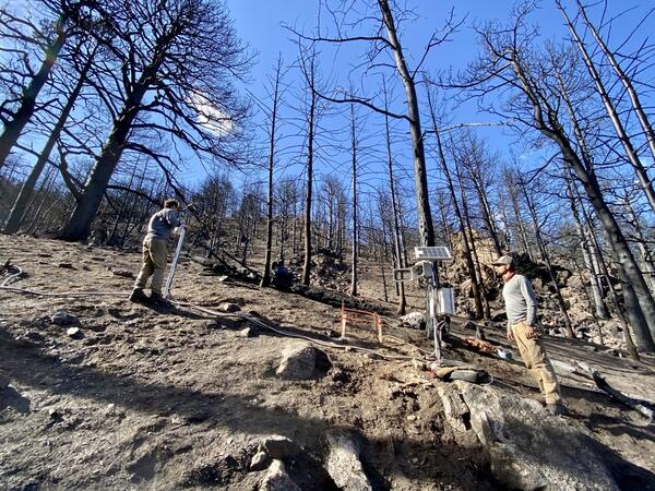
Hillslope monitoring in the 2020 Calwood Fire burn area, Boulder County, Colorado
Hillslope monitoring in the 2020 Calwood Fire burn area, Boulder County, ColoradoThree soil moisture sensors shown before their installation in a soil pit. The sensors will form a vertical subsurface array geared to track infiltration behavior.

Burned hillslopes following the 2020 Calwood Fire
This photograph of a small watershed within the 2020 Calwood Fire burn area, Boulder County, Colorado was taken 6 months following the fire. The removal of vegetation and change in soil properties make steeply burned areas susceptible to postfire debris flows.
This photograph of a small watershed within the 2020 Calwood Fire burn area, Boulder County, Colorado was taken 6 months following the fire. The removal of vegetation and change in soil properties make steeply burned areas susceptible to postfire debris flows.

Soil pit in the 2020 Calwood Fire burn area, Boulder County, Colorado
Soil pit in the 2020 Calwood Fire burn area, Boulder County, ColoradoSoil pit shown with three soil moisture sensors installed in a subsurface vertical array. The wetting and drying of the soil will be tracked over multi-annual timescales.

Monitoring station in the 2020 Calwood Fire burn area
Monitoring station in the 2020 Calwood Fire burn areaScientists installed a hillslope monitoring station following the 2020 Calwood Fire, Boulder County, Colorado. These monitoring stations help to collect data, such rainfall and soil moisture, that is used to better understand postfire debris-flow processes.

Soil moisture sensor prior to installation in the 2020 Calwood Fire burn area, Boulder County, Colorado
Soil moisture sensor prior to installation in the 2020 Calwood Fire burn area, Boulder County, ColoradoA soil moisture sensor shown prior to installation in a soil pit. This kind of sensor measures the dielectric constant of the soil using capacitance and frequency domain technology.

2020 Calwood Fire burn area, Boulder County, Colorado
2020 Calwood Fire burn area, Boulder County, ColoradoHillslopes in the 2020 Calwood Fire burn area covered by burned and partially burned trees. This photo was taken approximately 6 months after the fire.
2020 Calwood Fire burn area, Boulder County, Colorado
2020 Calwood Fire burn area, Boulder County, ColoradoHillslopes in the 2020 Calwood Fire burn area covered by burned and partially burned trees. This photo was taken approximately 6 months after the fire.
2020 Calwood Fire burn area hillslope monitoring station
2020 Calwood Fire burn area hillslope monitoring stationScientists install the 'Heil Ranch' monitoring station on a steeply burned hillslope within the 2020 Calwood Fire burn area, Boulder County, Colorado. The monitoring station collects data following wildfire to support research on postfire debris-flow processes.

2020 CZU Lightning Complex burn area, California
Postfire monitoring station within the 2020 CZU Lightning Complex burn area. This photograph was taken in February 2021 approximately 4.5 months after the fire was contained.
Postfire monitoring station within the 2020 CZU Lightning Complex burn area. This photograph was taken in February 2021 approximately 4.5 months after the fire was contained.

Eagle Rock, California Debris Flow
Rilling and a shallow landslide in CZU Fire near Eagle Rock, California. Soil ~3 cm below surface was almost completely dry after the rain storm, highlighting soil water repellancy.
Rilling and a shallow landslide in CZU Fire near Eagle Rock, California. Soil ~3 cm below surface was almost completely dry after the rain storm, highlighting soil water repellancy.
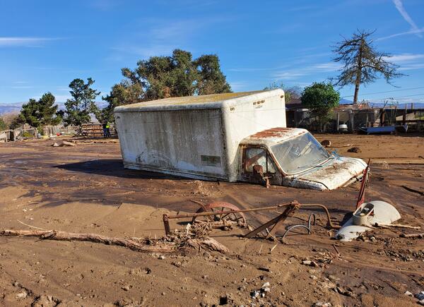
Postfire debris flood in the area burned by the 2020 River Fire
Postfire debris flood in the area burned by the 2020 River FireThe effects of debris floods following the 2020 River Fire in Monterey County, California.
Photo credit: Matthew A. Thomas, U.S. Geological Survey
Postfire debris flood in the area burned by the 2020 River Fire
Postfire debris flood in the area burned by the 2020 River FireThe effects of debris floods following the 2020 River Fire in Monterey County, California.
Photo credit: Matthew A. Thomas, U.S. Geological Survey

Big Sur, California Landslide - January 26 and 28, 2021
Big Sur, California Landslide - January 26 and 28, 2021The storm that hit California’s coast between Jan. 26 and 28, 2021, blew out a portion of Hwy 1 near Big Sur. On Saturday, a USGS reconnaissance flight snapped this dramatic photo above the Rat Creek drainage showing the debris flow.

Debris flow at Limekiln site after River Fire in California.
Debris flow at Limekiln site after River Fire in California.On Sunday, August 16, 2020 at approximately 3:00 PM PST, the River wildfire ignited in Monterey County, California, just west of the Salinas River Valley.
Debris flow at Limekiln site after River Fire in California.
Debris flow at Limekiln site after River Fire in California.On Sunday, August 16, 2020 at approximately 3:00 PM PST, the River wildfire ignited in Monterey County, California, just west of the Salinas River Valley.

Tumalt Creek Debris Flow
Debris flow deposit at the outlet of the Tumalt Creek drainage basin, Columbia River Gorge, Oregon, following storms in January 2021.
Debris flow deposit at the outlet of the Tumalt Creek drainage basin, Columbia River Gorge, Oregon, following storms in January 2021.

USGS scientist monitors the burn area following the Grizzly Creek fire of 2020
USGS scientist monitors the burn area following the Grizzly Creek fire of 2020USGS scientist monitors the burn area following the Grizzly Creek fire of 2020 in Glenwood Canyon, Colorado.
USGS scientist monitors the burn area following the Grizzly Creek fire of 2020
USGS scientist monitors the burn area following the Grizzly Creek fire of 2020USGS scientist monitors the burn area following the Grizzly Creek fire of 2020 in Glenwood Canyon, Colorado.

Burned trees following the 2020 Grizzly Creek fire in Glenwood Canyon, Colorado.
Burned trees following the 2020 Grizzly Creek fire in Glenwood Canyon, Colorado.Burned trees following the 2020 Grizzly Creek fire in Glenwood Canyon, Colorado.
Burned trees following the 2020 Grizzly Creek fire in Glenwood Canyon, Colorado.
Burned trees following the 2020 Grizzly Creek fire in Glenwood Canyon, Colorado.Burned trees following the 2020 Grizzly Creek fire in Glenwood Canyon, Colorado.

Rockfall boulders within the Mount Whitney Trailhead Campground
Rockfall boulders within the Mount Whitney Trailhead CampgroundAn image of 24 June 2020 (B4) and prehistoric (P2) outlier rockfall boulders within the Mount Whitney Trailhead Campground. Boulder P2 is approximately 3 m tall. The blue dashed line indicates one of several tent sites affected by the 2020 rockfalls.

Flyrock trajectory from the 24 June 2020 Whitney Portal Campground rockfall
Flyrock trajectory from the 24 June 2020 Whitney Portal Campground rockfallImages showing the flyrock trajectory from the 24 June 2020 rockfall (see previous figure). Rock impacts at the base of the talus slope split and moved boulders, launching a 0.5 cubic meter boulder 92 m into the lower parking lot at Whitney Portal.

Barry Arm of Harriman Fjord, Prince William Sound, Alaska
Barry Arm of Harriman Fjord, Prince William Sound, AlaskaBarry Arm of Harriman Fjord, Prince William Sound, Alaska. Included is Barry Glacier and Cascade Glacier.
Barry Arm of Harriman Fjord, Prince William Sound, Alaska
Barry Arm of Harriman Fjord, Prince William Sound, AlaskaBarry Arm of Harriman Fjord, Prince William Sound, Alaska. Included is Barry Glacier and Cascade Glacier.