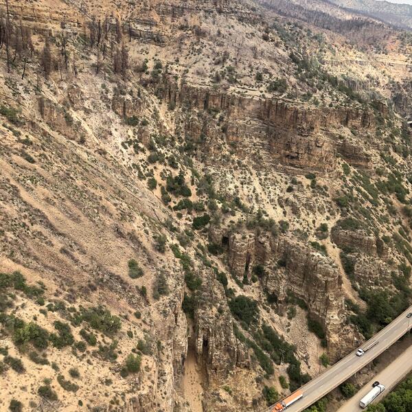
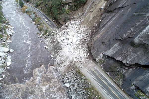
U.S. flag

An official website of the United States government

Images

Browse our photos of landslide research and post-landslide investigations.

Filter Total Items: 260
Interstate 70 in Glenwood Canyon, Colorado

Interstate 70 in Glenwood Canyon, Colorado. In the summer of 2021, travelers in Colorado's Glenwood Canyon were safely evacuated before massive debris flows buried highways and destroyed bridges, thanks to a debris flow warning system developed in part by the U.S. Geological Survey.

Interstate 70 in Glenwood Canyon, Colorado. In the summer of 2021, travelers in Colorado's Glenwood Canyon were safely evacuated before massive debris flows buried highways and destroyed bridges, thanks to a debris flow warning system developed in part by the U.S. Geological Survey.

Scientist assesses debris flow in Glenwood Canyon by measuring a hole in the ground
Scientist assesses debris flow in Glenwood Canyon

USGS scientist assesses debris flow in Glenwood Canyon, Colorado. This post-wildfire debris flow follows the 2020 Grizzly Creek Fire. 

person in small dirt trench with cap and gloves on
Pit for sensor installation in Maricao, Puerto Rico

Kelli Baxstrom excavates a pit for sensor installation at a monitoring site in Maricao, Puerto Rico.

road at base of steep slope next to river, and rocks covering the road at one point
Rockslide on California State Route 70 in the Feather River Canyon, Butte/Plumas county line, northern California

Rockslide on California State Route 70 in the Feather River Canyon, Butte/Plumas county line, northern California. This slide was triggered on October 24, 2021 by a Category 5 atmospheric river, which released more than ten inches of rain in the area over a 48-hour period. Approximately seven thousand cubic yards of rock and debris buried and closed the highway.

Rockslide on California State Route 70 in the Feather River Canyon, Butte/Plumas county line, northern California. This slide was triggered on October 24, 2021 by a Category 5 atmospheric river, which released more than ten inches of rain in the area over a 48-hour period. Approximately seven thousand cubic yards of rock and debris buried and closed the highway.

mountainous valley with burn scar in foreground and person near an instrument with a solar panel
Chambers Landslide Monitoring Site, 2021 Dixie Fire, near Belden, California

The USGS “Chambers” site is located in the Plumas National Forest in northern California. The site consists of instrumentation monitoring the hillslope in the lower part of the image. The hillslope exhibits moderate soil burn severity and hosts sandy soils derived from granitic bedrock.

The USGS “Chambers” site is located in the Plumas National Forest in northern California. The site consists of instrumentation monitoring the hillslope in the lower part of the image. The hillslope exhibits moderate soil burn severity and hosts sandy soils derived from granitic bedrock.

mountain tops with burn scars, and landslide instrument in foreground
Chips Landslide Monitoring Site, 2021 Dixie Fire, near Belden, California

The USGS “Chips” site is located in the Plumas National Forest in northern California. The site consists of instrumentation monitoring the hillslope in the lower part of the image. The hillslope exhibits moderate soil burn severity and hosts silty soils derived from metamorphic bedrock.

The USGS “Chips” site is located in the Plumas National Forest in northern California. The site consists of instrumentation monitoring the hillslope in the lower part of the image. The hillslope exhibits moderate soil burn severity and hosts silty soils derived from metamorphic bedrock.

A hillslope covered with grass and partially burned trees
Recovery in the Grizzly Creek burn area

The hillslopes above Cinnamon Creek within the Grizzly Creek burn area one year following the Grizzly Creek fire.  

People standing on hillslope covered with sparse grass and burned trees
Recovery in the Grizzly Creek burn area

Hillslope recovery along Blue Gulch in the Grizzly Creek burn area.  This photo was taken approximately 1 year following the Grizzly Creek fire. 

Hillslope recovery along Blue Gulch in the Grizzly Creek burn area.  This photo was taken approximately 1 year following the Grizzly Creek fire. 

mud covering highway
Debris Flows Across I-70 in Glenwood Canyon, Colorado

Ground level view of debris covering the eastbound lane of I-70 following the June 26-27, 2021, storms. The green sign in the background indicating Milepost 120 is mostly buried by mud.

Ground level view of debris covering the eastbound lane of I-70 following the June 26-27, 2021, storms. The green sign in the background indicating Milepost 120 is mostly buried by mud.

hillslope covered with burned trees and boulders
2020 Calwood Fire burn area

2020 Calwood Fire burn area, Boulder County, Colorado. This overview photo looking west from the ridge separating the 'Calwood' side of the burn area from the 'Heil Ranch' side.  The photo was taken approximately 7 months after the fire, which occurred in the fall of 2020.

2020 Calwood Fire burn area, Boulder County, Colorado. This overview photo looking west from the ridge separating the 'Calwood' side of the burn area from the 'Heil Ranch' side.  The photo was taken approximately 7 months after the fire, which occurred in the fall of 2020.

forest with burned trees and very little vegetation.  A piece of equipment is being installed on burned hillside
2020 Calwood Fire burn area monitoring station

A scientist installs a hillslope monitoring station in the 'Heil Ranch' section of the 2020 Calwood Fire burn area.  Hillslope monitoring stations collect data about rainfall and soil properties, and record debris flows that occur in burned watersheds.  

A scientist installs a hillslope monitoring station in the 'Heil Ranch' section of the 2020 Calwood Fire burn area.  Hillslope monitoring stations collect data about rainfall and soil properties, and record debris flows that occur in burned watersheds.  

hillslope devoid of vegetation covered with dark soil, small boulders, and burned trees
2020 Calwood Fire burn area, Boulder County, Colorado

Burned hillslope in the 2020 Calwood Fire burn area, Boulder County, Colorado.  This hillslope sits above a very small drainage area and is still devoid of vegetation approximately 7 months following the fire.  Small rills or incisions on the slope formed in areas where runoff became concentrated.  

Burned hillslope in the 2020 Calwood Fire burn area, Boulder County, Colorado.  This hillslope sits above a very small drainage area and is still devoid of vegetation approximately 7 months following the fire.  Small rills or incisions on the slope formed in areas where runoff became concentrated.  

steep hillslope with boulders and burned tree remnants
2020 Calwood Fire burn area, Boulder County, Colorado

Overview photograph of the area burned by the 2020 Calwood Fire in Boulder County, Colorado.  The hillslopes are covered by burned tree remnants and boulders. In this view, very little vegetation has returned.  

Overview photograph of the area burned by the 2020 Calwood Fire in Boulder County, Colorado.  The hillslopes are covered by burned tree remnants and boulders. In this view, very little vegetation has returned.  

a hillslope in a burned forest partially covered with new vegetation
Recovery in the 2020 Calwood Fire burn area, Boulder County, Colorado

Approximately 7 months following the Calwood Fire, Boulder County, Colorado vegetation begins to regrow on the burned hillslope.  

Rain Gauge installed after Grizzly Creek fire

Rain Gauge installed after the 2020 Grizzly Creek fire in Glenwood Canyon, Colorado. Scientists installed a network of rain gauges and soil moisture sensors throughout the rugged burn area. These instruments provide real-time data on rainfall intensity and duration, which are critical factors in determining the likelihood of a debris flow. 

Rain Gauge installed after the 2020 Grizzly Creek fire in Glenwood Canyon, Colorado. Scientists installed a network of rain gauges and soil moisture sensors throughout the rugged burn area. These instruments provide real-time data on rainfall intensity and duration, which are critical factors in determining the likelihood of a debris flow. 

Rain gauge in Glenwood Canyon

Rain gauge in Glenwood Canyon, Colorado. After the 2020 Grizzly Creek fire, scientists installed a network of rain gauges and soil moisture sensors throughout the rugged burn area. These instruments provide real-time data on rainfall intensity and duration, which are critical factors in determining the likelihood of a debris flow. 

Rain gauge in Glenwood Canyon, Colorado. After the 2020 Grizzly Creek fire, scientists installed a network of rain gauges and soil moisture sensors throughout the rugged burn area. These instruments provide real-time data on rainfall intensity and duration, which are critical factors in determining the likelihood of a debris flow. 

Rain gauge installed in Glenwood Canyon, Colorado

Rain gauge installed in Glenwood Canyon, Colorado. After the 2020 Grizzly Creek fire, scientists installed a network of rain gauges and soil moisture sensors throughout the rugged burn area. These instruments provide real-time data on rainfall intensity and duration, which are critical factors in determining the likelihood of a debris flow. 

Rain gauge installed in Glenwood Canyon, Colorado. After the 2020 Grizzly Creek fire, scientists installed a network of rain gauges and soil moisture sensors throughout the rugged burn area. These instruments provide real-time data on rainfall intensity and duration, which are critical factors in determining the likelihood of a debris flow. 

Hand holding several wires labeled with tags
Hillslope monitoring in the 2020 Calwood Fire burn area, Boulder County, Colorado

Three soil moisture sensors shown before their installation in a soil pit. The sensors will form a vertical subsurface array geared to track infiltration behavior. 

hillslope with burned trees and devoid of other vegetation
Burned hillslopes following the 2020 Calwood Fire

This photograph of a small watershed within the 2020 Calwood Fire burn area, Boulder County, Colorado was taken 6 months following the fire.  The removal of vegetation and change in soil properties make steeply burned areas susceptible to postfire debris flows.  

This photograph of a small watershed within the 2020 Calwood Fire burn area, Boulder County, Colorado was taken 6 months following the fire.  The removal of vegetation and change in soil properties make steeply burned areas susceptible to postfire debris flows.  

soil pit with measuring tape to record depth
Soil pit in the 2020 Calwood Fire burn area, Boulder County, Colorado

Soil pit shown with three soil moisture sensors installed in a subsurface vertical array. The wetting and drying of the soil will be tracked over multi-annual timescales. 

Was this page helpful?