NATIONAL LANDSLIDE SUSCEPTIBILITY MAP
Images
Browse our photos of landslide research and post-landslide investigations.
Burned and unburned hillslopes, Eaton Fire, California
Burned and unburned hillslopes, Eaton Fire, CaliforniaThe boundary between burned and unburned terrain in the area burned by the 2025 Eaton Fire, Angeles National Forest, California. Fire has removed all of the vegetation in the area of the hillslope visible in the image foreground.
Burned and unburned hillslopes, Eaton Fire, California
Burned and unburned hillslopes, Eaton Fire, CaliforniaThe boundary between burned and unburned terrain in the area burned by the 2025 Eaton Fire, Angeles National Forest, California. Fire has removed all of the vegetation in the area of the hillslope visible in the image foreground.
A steep, burned hillside in the 2025 Eaton Fire, Los Angeles County, California.
A steep, burned hillside in the 2025 Eaton Fire, Los Angeles County, California.A steep, burned hillside in the 2025 Eaton Fire, Los Angeles County, California. The hillside is located near the northwestern edge of the burn perimeter, just off of Sunset Ridge road. High winds while the fire burned and after it was contained has removed ash from the hillside.
A steep, burned hillside in the 2025 Eaton Fire, Los Angeles County, California.
A steep, burned hillside in the 2025 Eaton Fire, Los Angeles County, California.A steep, burned hillside in the 2025 Eaton Fire, Los Angeles County, California. The hillside is located near the northwestern edge of the burn perimeter, just off of Sunset Ridge road. High winds while the fire burned and after it was contained has removed ash from the hillside.
Soil property measurements in the Eaton Fire burn area, Angeles National Forest, California
Soil property measurements in the Eaton Fire burn area, Angeles National Forest, CaliforniaSoil property measurements in the Eaton Fire burn area, Angeles National Forest, California. A scientist uses a Mini Disk infiltrometer to measure how fast water infiltrates the ground's surface in the 2025 Eaton Fire burn area. Infiltrometer measurements help determine soil burn severity.
Soil property measurements in the Eaton Fire burn area, Angeles National Forest, California
Soil property measurements in the Eaton Fire burn area, Angeles National Forest, CaliforniaSoil property measurements in the Eaton Fire burn area, Angeles National Forest, California. A scientist uses a Mini Disk infiltrometer to measure how fast water infiltrates the ground's surface in the 2025 Eaton Fire burn area. Infiltrometer measurements help determine soil burn severity.
POSTFIRE DEBRIS FLOW SCIENCE
The U.S. Geological Survey helps local, state, and federal agencies assess debris flow hazards in recently burned areas. We provide information about the likelihood of debris flow activity, where they might happen, and how big they might be.
DEBRIS FLOW ASSESSMENTS
POSTFIRE DEBRIS FLOW SCIENCE
The U.S. Geological Survey helps local, state, and federal agencies assess debris flow hazards in recently burned areas. We provide information about the likelihood of debris flow activity, where they might happen, and how big they might be.
DEBRIS FLOW ASSESSMENTS
A detailed look at a hillslope within the Eaton Fire burn area showing sediment particles, visible in the foreground, moving downslope. Remnants of burned trees and other vegetation are also visible on the hillslope.
West Ravine debris basin in Los Angeles County, California on January 20, 2025.
West Ravine debris basin in Los Angeles County, California on January 20, 2025.The West Ravine debris basin in Los Angeles County, California on January 20, 2024. The debris basin is mostly empty, with remnants of debris being cleared by a front loader and dump truck. This photograph was taken following the 2025 Eaton wildfire and prior to any rainfall over the burn area.
West Ravine debris basin in Los Angeles County, California on January 20, 2025.
West Ravine debris basin in Los Angeles County, California on January 20, 2025.The West Ravine debris basin in Los Angeles County, California on January 20, 2024. The debris basin is mostly empty, with remnants of debris being cleared by a front loader and dump truck. This photograph was taken following the 2025 Eaton wildfire and prior to any rainfall over the burn area.
A steep, burned hillside in the 2025 Eaton Fire, Los Angeles County, California.
A steep, burned hillside in the 2025 Eaton Fire, Los Angeles County, California.A steep, burned hillside in the 2025 Eaton Fire, Los Angeles County, California. The hillside is located near the northern edge of the burn perimeter off of Echo Mountain Low Fire Road. Unburned, vegetated terrain is visible in the image background. This photo was taken shortly after the Eaton Fire was contained.
A steep, burned hillside in the 2025 Eaton Fire, Los Angeles County, California.
A steep, burned hillside in the 2025 Eaton Fire, Los Angeles County, California.A steep, burned hillside in the 2025 Eaton Fire, Los Angeles County, California. The hillside is located near the northern edge of the burn perimeter off of Echo Mountain Low Fire Road. Unburned, vegetated terrain is visible in the image background. This photo was taken shortly after the Eaton Fire was contained.
LANDSLIDE SAFETY
If your home or property was damaged by a landslide from Hurricane Helene, be aware of the warning signs of future landslide activity
WATCH FOR WARNING SIGNS
Signs a landslide may be moving include:
LANDSLIDE SAFETY
If your home or property was damaged by a landslide from Hurricane Helene, be aware of the warning signs of future landslide activity
WATCH FOR WARNING SIGNS
Signs a landslide may be moving include:
A boulder-rich postfire debris-flow deposit in the 2024 Salt fire burn area. Flooding and debris flows occurred near Ruidoso, New Mexico during rain events shortly following the 2024 wildfires. This photo was taken in Bear Canyon, on the Mescalero Reservation, near the central portion of the burn area.
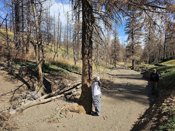
Damaged tree in the 2024 South Fork Fire burn area, New Mexico
Damaged tree in the 2024 South Fork Fire burn area, New MexicoA scientist examines a tree that sits within a mud- and boulder-filled channel in the 2024 South Fork fire burn area. The sediment filling the channel was deposited by a postfire debris flow or flood that occurred during a rain event following the wildfire.
Damaged tree in the 2024 South Fork Fire burn area, New Mexico
Damaged tree in the 2024 South Fork Fire burn area, New MexicoA scientist examines a tree that sits within a mud- and boulder-filled channel in the 2024 South Fork fire burn area. The sediment filling the channel was deposited by a postfire debris flow or flood that occurred during a rain event following the wildfire.
Debris-flow deposit in the 2024 South Fork Fire burn area
Debris-flow deposit in the 2024 South Fork Fire burn areaA poorly-sorted, debris-flow levee deposited during a rain event following the 2024 South Fork Fire. Levees form at the margins of debris flows are matrix-supported, and comprised of variably-sized sediment. Levees are useful for field identification of debris flow deposits and help to differentiate them from flood deposits.
Debris-flow deposit in the 2024 South Fork Fire burn area
Debris-flow deposit in the 2024 South Fork Fire burn areaA poorly-sorted, debris-flow levee deposited during a rain event following the 2024 South Fork Fire. Levees form at the margins of debris flows are matrix-supported, and comprised of variably-sized sediment. Levees are useful for field identification of debris flow deposits and help to differentiate them from flood deposits.
Debris-flow deposit in the South Fork Fire burn area
Debris-flow deposit in the South Fork Fire burn areaA mud- to boulder-sized debris-flow deposit in the South Fork Fire burn area, New Mexico. Flooding and debris-flows occurred as a result of rain events shortly following the summer wildfire. This photo was taken in the South Fork Cedar Creek drainage near the center of the burn area approximately 4 months following the wildfire.
Debris-flow deposit in the South Fork Fire burn area
Debris-flow deposit in the South Fork Fire burn areaA mud- to boulder-sized debris-flow deposit in the South Fork Fire burn area, New Mexico. Flooding and debris-flows occurred as a result of rain events shortly following the summer wildfire. This photo was taken in the South Fork Cedar Creek drainage near the center of the burn area approximately 4 months following the wildfire.
Debris-flow fan in the 2024 South Fork Fire burn area
Debris-flow fan in the 2024 South Fork Fire burn areaA debris-flow fan near the outlet of the North Fork Cedar Creek in the South Fork Fire burn area. Floods and debris flows occurred during rain events following the summer wildfire. This drainage is located near the center of the burn area and the photo was taken approximately 4 months following the wildfire.
Debris-flow fan in the 2024 South Fork Fire burn area
Debris-flow fan in the 2024 South Fork Fire burn areaA debris-flow fan near the outlet of the North Fork Cedar Creek in the South Fork Fire burn area. Floods and debris flows occurred during rain events following the summer wildfire. This drainage is located near the center of the burn area and the photo was taken approximately 4 months following the wildfire.
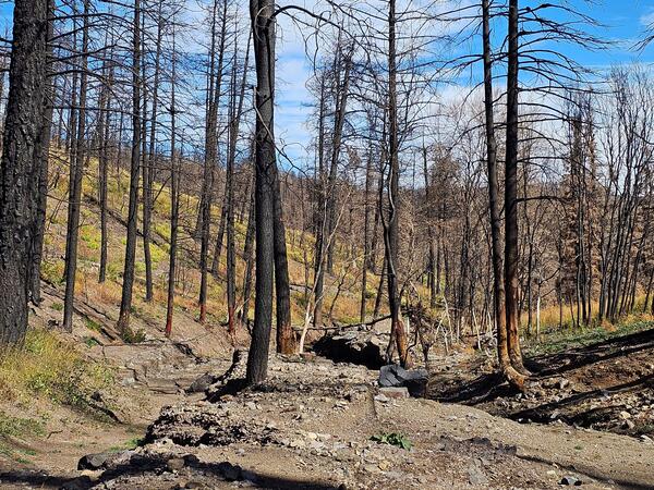
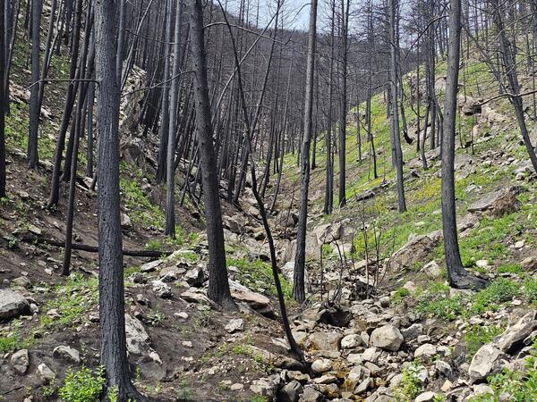
Debris-filled channel in the 2024 South Fork Fire burn area
Debris-filled channel in the 2024 South Fork Fire burn areaA debris flow or flood that occurred in 2024 South Fork Fire burn area filled the channel with mud- to boulder-sized sediment. Flooding flows occurred during rain events following the summer wildfire. Note the removal of bark and damage to trees in and adjacent to the channel.
Debris-filled channel in the 2024 South Fork Fire burn area
Debris-filled channel in the 2024 South Fork Fire burn areaA debris flow or flood that occurred in 2024 South Fork Fire burn area filled the channel with mud- to boulder-sized sediment. Flooding flows occurred during rain events following the summer wildfire. Note the removal of bark and damage to trees in and adjacent to the channel.
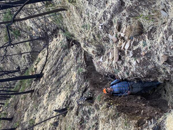
Channel erosion in the 2024 South Fork Fire burn area
Channel erosion in the 2024 South Fork Fire burn areaA scientist stands within a deeply eroded channel in the 2024 South Fork Fire burn area, New Mexico. Increased surface runoff on recently burned hillslopes can lead to rapid channel widening and deepening due to rapid erosion. Straw mulch, which is sometimes used to mitigate flooding, is visible across much of the ground's surface.
Channel erosion in the 2024 South Fork Fire burn area
Channel erosion in the 2024 South Fork Fire burn areaA scientist stands within a deeply eroded channel in the 2024 South Fork Fire burn area, New Mexico. Increased surface runoff on recently burned hillslopes can lead to rapid channel widening and deepening due to rapid erosion. Straw mulch, which is sometimes used to mitigate flooding, is visible across much of the ground's surface.
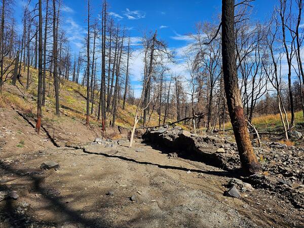
Debris-flow deposit in the 2024 South Fork Fire burn area, New Mexico
Debris-flow deposit in the 2024 South Fork Fire burn area, New MexicoMud- to boulder-sized sediment fill a channel in the 2024 South Fork Fire burn area. The sediment was deposited by flooding and debris flows during rain events following the summer wildfire. The coarsest material (including several large boulders) was deposited on the south side of the channel, forming a debris-flow levee.
Debris-flow deposit in the 2024 South Fork Fire burn area, New Mexico
Debris-flow deposit in the 2024 South Fork Fire burn area, New MexicoMud- to boulder-sized sediment fill a channel in the 2024 South Fork Fire burn area. The sediment was deposited by flooding and debris flows during rain events following the summer wildfire. The coarsest material (including several large boulders) was deposited on the south side of the channel, forming a debris-flow levee.
Damage caused by a large mudflow in Buck Creek near Marion, NC. - 10/17/2024
Damage caused by a large mudflow in Buck Creek near Marion, NC. - 10/17/2024Coordinates of photographer: Latitude: 35° 44’ 16.08” N Longitude: 82° 8’ 20.04” W
Date: 10/17/24
Caption: Damage caused by a large mudflow in Buck Creek near Marion, NC.
Taken during Hurricane Helene LASER response
Damage caused by a large mudflow in Buck Creek near Marion, NC. - 10/17/2024
Damage caused by a large mudflow in Buck Creek near Marion, NC. - 10/17/2024Coordinates of photographer: Latitude: 35° 44’ 16.08” N Longitude: 82° 8’ 20.04” W
Date: 10/17/24
Caption: Damage caused by a large mudflow in Buck Creek near Marion, NC.
Taken during Hurricane Helene LASER response
Damage caused by mudflows into Flat Creek near the Garren Creek Fire Station. - 10/17/2024
Damage caused by mudflows into Flat Creek near the Garren Creek Fire Station. - 10/17/2024Coordinates of photographer: Latitude: 35° 33’ 21.75” N, Longitude: 82° 19’ 0.9” W
Date: 10/17/24
Caption: Damage caused by mudflows into Flat Creek near the Garren Creek Fire Station. Some of the initiating landslides are visible in the distance, upper left of photo.
Taken during Hurricane Helene LASER response
Damage caused by mudflows into Flat Creek near the Garren Creek Fire Station. - 10/17/2024
Damage caused by mudflows into Flat Creek near the Garren Creek Fire Station. - 10/17/2024Coordinates of photographer: Latitude: 35° 33’ 21.75” N, Longitude: 82° 19’ 0.9” W
Date: 10/17/24
Caption: Damage caused by mudflows into Flat Creek near the Garren Creek Fire Station. Some of the initiating landslides are visible in the distance, upper left of photo.
Taken during Hurricane Helene LASER response
Oblique aerial view of a debris-flow runout path near Fairview, North Carolina. The debris flow was triggered by heavy and prolonged rainfall during Hurricane Helene in fall 2024. The photograph was collected during a U.S. Geological Survey aerial reconnaissance flight documenting widespread landsliding and flooding associated with the storm.
Coordinates of photographer: Latitude: 36° 15’ 31.74” N Longitude: 81° 44’ 32.952” W
Date 10/13/24
Caption: A landslide near Vilas, NC.
Taken as part of Hurricane Helene LASER response
Coordinates of photographer: Latitude: 36° 15’ 31.74” N Longitude: 81° 44’ 32.952” W
Date 10/13/24
Caption: A landslide near Vilas, NC.
Taken as part of Hurricane Helene LASER response