
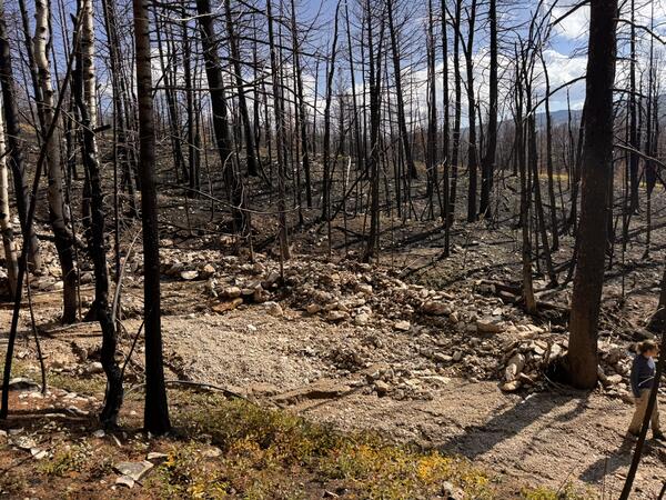
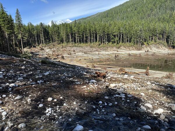
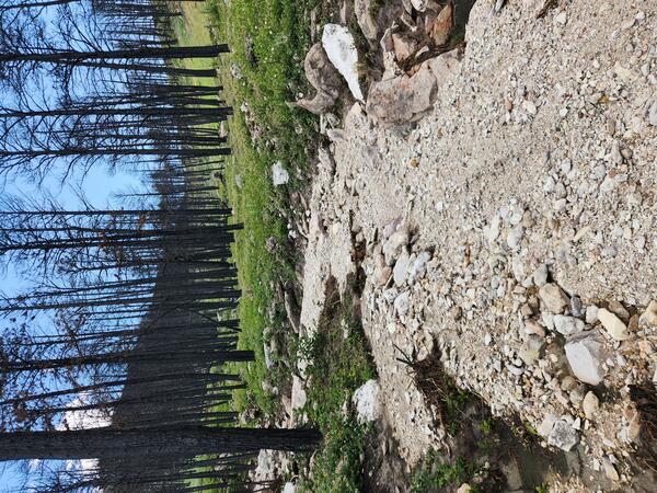
Rocks, mud, and woody debris deposited by both flood and debris flow processes are visible in this upstream section of watershed burned by the 2024 Elk Fire near Dayton, Wyoming. The coarser material near the far channel edge was carried by a debris flow while the well-sorted finer material in the foreground has properties associated with flood flow.
Images
Browse our photos of landslide research and post-landslide investigations.
Filter Total Items: 266
Debris-flow levee in the 2024 Elk Fire burn area
Rocks, mud, and woody debris deposited by both flood and debris flow processes are visible in this upstream section of watershed burned by the 2024 Elk Fire near Dayton, Wyoming. The coarser material near the far channel edge was carried by a debris flow while the well-sorted finer material in the foreground has properties associated with flood flow.
Debris-flow deposit in the 2024 Elk Fire burn area near Dayton, Wyoming
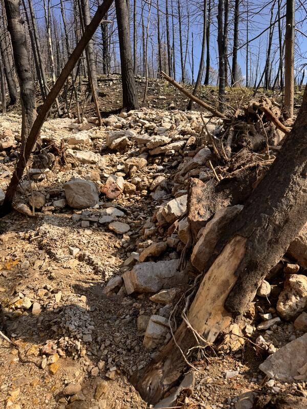
Debris-flow deposit in the 2024 Elk Fire burn area near Dayton, WyomingDebris-flow deposit in the 2024 Elk Fire burn area near Dayton, Wyoming. A close-up view of a debris-flow deposit located in the upstream section of a burned watershed. This deposit is poorly sorted, and contains mud, gravel, boulders, and woody debris. Damaged bark on the tree in the foreground suggests impact from larger material carried by a fast-moving flow.
Debris-flow deposit in the 2024 Elk Fire burn area near Dayton, Wyoming
Debris-flow deposit in the 2024 Elk Fire burn area near Dayton, WyomingDebris-flow deposit in the 2024 Elk Fire burn area near Dayton, Wyoming. A close-up view of a debris-flow deposit located in the upstream section of a burned watershed. This deposit is poorly sorted, and contains mud, gravel, boulders, and woody debris. Damaged bark on the tree in the foreground suggests impact from larger material carried by a fast-moving flow.
Flow deposit in the 2024 Elk Fire burn area
Storm runoff deposited mud, gravel, and small boulders onto Lower Dry Fork Road which runs below the steep watersheds burned by the 2024 Elk Fire near Dayton, Wyoming.
Storm runoff deposited mud, gravel, and small boulders onto Lower Dry Fork Road which runs below the steep watersheds burned by the 2024 Elk Fire near Dayton, Wyoming.
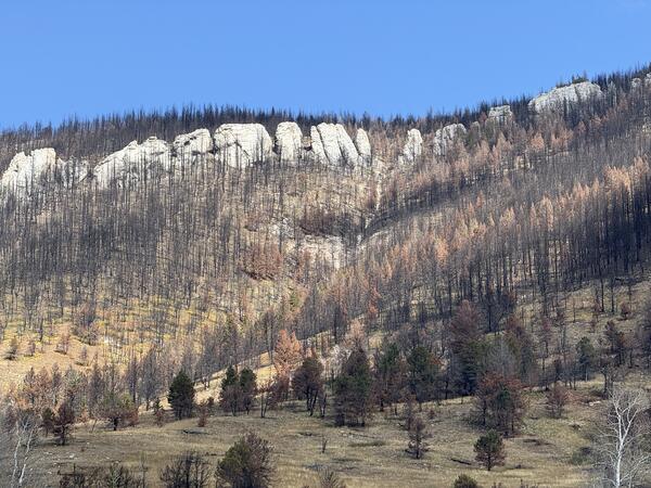
Burned hillslopes in the 2024 Elk Fire burn area near Dayton, Wyoming
Burned hillslopes in the 2024 Elk Fire burn area near Dayton, WyomingA view looking upslope toward the burned hillsides below Dry Fork Ridge in the Bighorn National Forest within the 2024 Elk Fire burn area.
Burned hillslopes in the 2024 Elk Fire burn area near Dayton, Wyoming
Burned hillslopes in the 2024 Elk Fire burn area near Dayton, WyomingA view looking upslope toward the burned hillsides below Dry Fork Ridge in the Bighorn National Forest within the 2024 Elk Fire burn area.
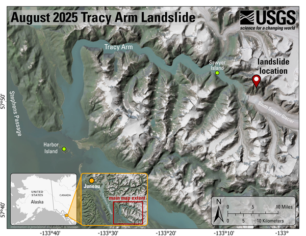
2025 Tracy Arm Landslide Overview Map
Overview map and location of the Tracy Arm landslide-generated tsunami event. The imagery is not current, and the South Sawyer Glacier has retreated over a kilometer from what is depicted.
Overview map and location of the Tracy Arm landslide-generated tsunami event. The imagery is not current, and the South Sawyer Glacier has retreated over a kilometer from what is depicted.
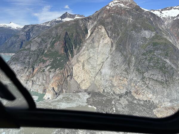
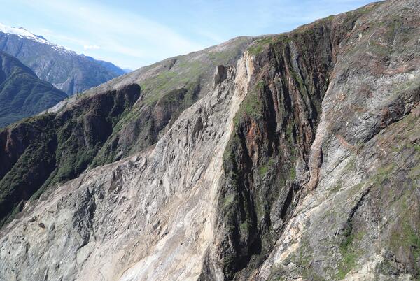
2025 Tracy Arm Landslide Source Area
Oblique aerial photo of the August 10, 2025 landslide source area captured during a field reconnaissance overflight on August 13, 2025. Look direction is approximately north.
Oblique aerial photo of the August 10, 2025 landslide source area captured during a field reconnaissance overflight on August 13, 2025. Look direction is approximately north.
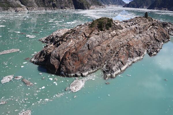
Sawyer Island after 2025 Tracy Arm Landslide
Oblique aerial photo of Sawyer Island captured during a field reconnaissance overflight on August 13, 2025. Look direction is to the southeast.
Oblique aerial photo of Sawyer Island captured during a field reconnaissance overflight on August 13, 2025. Look direction is to the southeast.
2025 Tracy Arm Landslide Aerial Photo Facing West
Oblique aerial photo of the August 10, 2025 landslide captured during a field reconnaissance overflight on August 13, 2025. Look direction is to the west.
Oblique aerial photo of the August 10, 2025 landslide captured during a field reconnaissance overflight on August 13, 2025. Look direction is to the west.
2025 Tracy Arm Landslide Tsunami-Inundated Shoreline
2025 Tracy Arm Landslide Tsunami-Inundated ShorelinePhoto of tsunami-inundated shoreline at Williams Cove, near the mouth of Tracy Arm. Look direction is approximately north.
2025 Tracy Arm Landslide Tsunami-Inundated Shoreline
2025 Tracy Arm Landslide Tsunami-Inundated ShorelinePhoto of tsunami-inundated shoreline at Williams Cove, near the mouth of Tracy Arm. Look direction is approximately north.
2025 Tracy Arm Landslide Headscarp
Oblique aerial photo of the August 10, 2025 landslide headscarp. Look direction is to the northwest.
Oblique aerial photo of the August 10, 2025 landslide headscarp. Look direction is to the northwest.
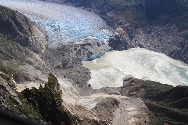
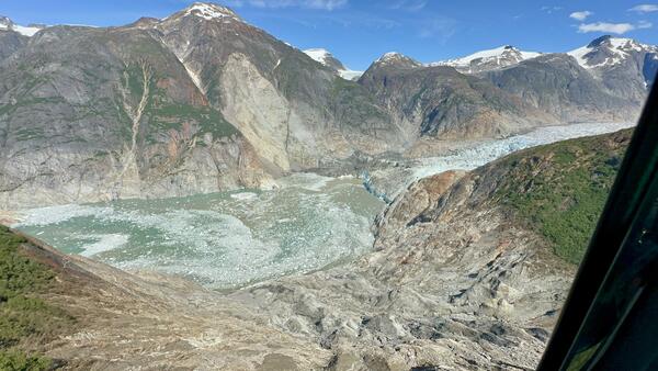
2025 Tracy Arm Landslide Runup Zone and South Sawyer Glacier
2025 Tracy Arm Landslide Runup Zone and South Sawyer GlacierOblique aerial photo of the August 10, 2025 landslide across-fiord runup zone and South Sawyer Glacier captured during a field reconnaissance overflight on August 13, 2025. Look direction is to the southeast.

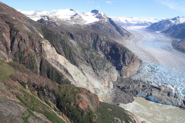
2025 Tracy Arm Landslide Source Area Facing Northwest
2025 Tracy Arm Landslide Source Area Facing NorthwestOblique aerial photo of the August 10, 2025 landslide, and tsunami trimline, captured during a field reconnaissance overflight on August 13, 2025. Look direction is to the northwest.
2025 Tracy Arm Landslide Source Area Facing Northwest
2025 Tracy Arm Landslide Source Area Facing NorthwestOblique aerial photo of the August 10, 2025 landslide, and tsunami trimline, captured during a field reconnaissance overflight on August 13, 2025. Look direction is to the northwest.
2025 Tracy Arm Landslide Facing South
Oblique aerial photo of the August 10, 2025 landslide. Look direction is to the south.
Oblique aerial photo of the August 10, 2025 landslide. Look direction is to the south.
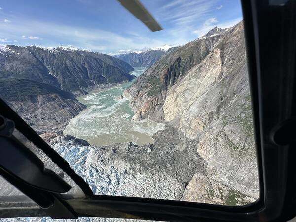
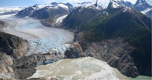
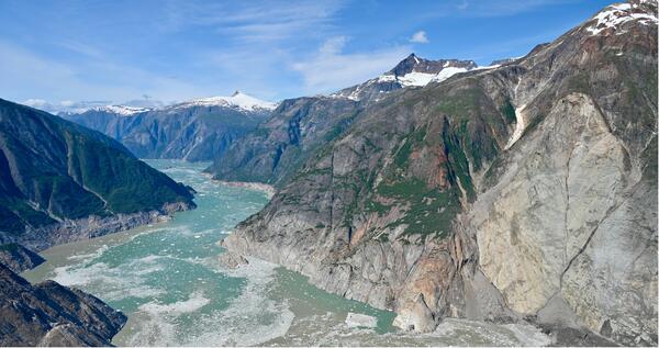
2025 Tracy Arm Landslide and South Sawyer Glacier Facing the Southeast
2025 Tracy Arm Landslide and South Sawyer Glacier Facing the SoutheastOblique aerial photo of the August 10, 2025 landslide and South Sawyer Glacier captured during a field reconnaissance overflight on August 13, 2025. Look direction is to the southeast.
2025 Tracy Arm Landslide and Tsunami Trimline
Oblique aerial photo of the August 10, 2025 landslide source area captured during a field reconnaissance overflight on August 13, 2025. Look direction is approximately north.
Oblique aerial photo of the August 10, 2025 landslide source area captured during a field reconnaissance overflight on August 13, 2025. Look direction is approximately north.
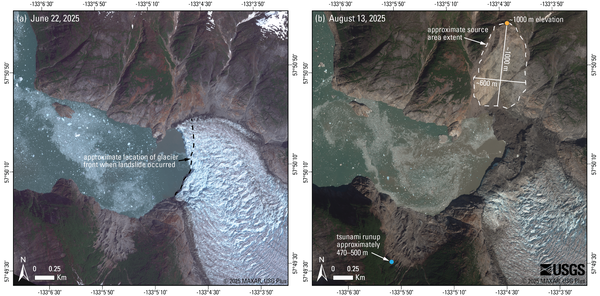
2025 Tracy Arm Landslide Before and After Satellite Imagery
2025 Tracy Arm Landslide Before and After Satellite ImageryComparison of (a) pre- and (b) post-event satellite images showing the source area of the August 10th landslide that impacted Tracy Arm. The dashed line in (a) shows the approximate location of the front of South Sawyer Glacier on August 7th, 2025 (mapped from imagery © 2025 Planet Labs PBC).
2025 Tracy Arm Landslide Across the Fiord Facing North
2025 Tracy Arm Landslide Across the Fiord Facing NorthOblique aerial photo of the August 10, 2025 landslide taken from across the fiord during a field reconnaissance overflight on August 13, 2025. Look direction is approximately north.
2025 Tracy Arm Landslide Across the Fiord Facing North
2025 Tracy Arm Landslide Across the Fiord Facing NorthOblique aerial photo of the August 10, 2025 landslide taken from across the fiord during a field reconnaissance overflight on August 13, 2025. Look direction is approximately north.
Debris-flow deposit in the 2024 Elk Fire burn area
Debris-flow deposit in the 2024 Elk Fire burn areaDebris-flow deposit in the 2024 Elk Fire burn area near Dayton, Wyoming is comprised of poorly sorted, mud- to boulder-sized sediment. A small amount of woody debris is intermixed with the sediment that fills channel.
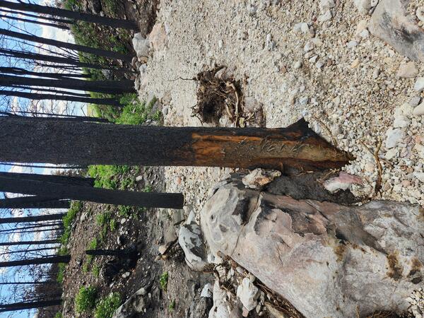
Tree damage in the 2024 Elk Fire burn area.
The bark at the base of a tree in a burned watershed in the 2024 Ek Fire burn area has been partially removed by fast-moving water and debris. This damage occurs as debris flows pass through the channel and sediment suspended in the flow scrapes bark off of trees.
The bark at the base of a tree in a burned watershed in the 2024 Ek Fire burn area has been partially removed by fast-moving water and debris. This damage occurs as debris flows pass through the channel and sediment suspended in the flow scrapes bark off of trees.
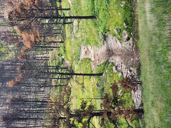
Postfire runoff in the 2024 Elk Fire buran area near Dayton, Wyoming
Postfire runoff in the 2024 Elk Fire buran area near Dayton, WyomingRunoff during a 2025 summer thunderstorm carried material downstream in this relatively small channel in the High Water Creek watershed within the Elk Fire burn area.
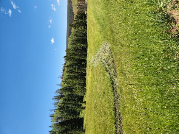
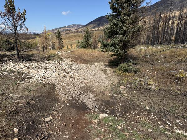
Runoff in the 2024 Elk Fire burn area
Runoff in the 2024 Elk Fire burn area. This meadow near a watershed outlet along Lower Dry Fork Road shows a shallow channel formed during Summer 2025. Although vegetation is recovering, runoff deposited mud and flattened grasses in this low-slope area.
Runoff in the 2024 Elk Fire burn area. This meadow near a watershed outlet along Lower Dry Fork Road shows a shallow channel formed during Summer 2025. Although vegetation is recovering, runoff deposited mud and flattened grasses in this low-slope area.