
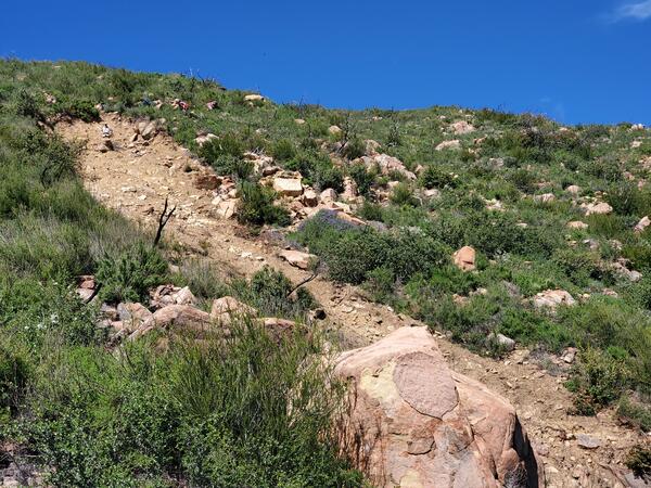
Translational slide: In this type of slide, the landslide mass moves along a roughly planar surface with little rotation or backward tilting.
Images
Browse our photos of landslide research and post-landslide investigations.
Filter Total Items: 265

Translational Landslide
Translational slide: In this type of slide, the landslide mass moves along a roughly planar surface with little rotation or backward tilting.

Debris Flow
A debris flow is a form of rapid mass movement in which a combination of loose soil, rock, organic matter, air, and water mobilizes as a slurry that flows downslope. Debris flows include <50% fines.
A debris flow is a form of rapid mass movement in which a combination of loose soil, rock, organic matter, air, and water mobilizes as a slurry that flows downslope. Debris flows include <50% fines.

Lateral Spread
Lateral spreads are distinctive because they usually occur on very gentle slopes or flat terrain. The dominant mode of movement is lateral extension accompanied by shear or tensile fractures.
Lateral spreads are distinctive because they usually occur on very gentle slopes or flat terrain. The dominant mode of movement is lateral extension accompanied by shear or tensile fractures.

Topple
Toppling failures are distinguished by the forward rotation of a unit or units about some pivotal point, below or low in the unit, under the actions of gravity and forces exerted by adjacent units or by fluids in cracks.
Toppling failures are distinguished by the forward rotation of a unit or units about some pivotal point, below or low in the unit, under the actions of gravity and forces exerted by adjacent units or by fluids in cracks.

Rotational Landslide
Rotational slide: This is a slide in which the surface of rupture is curved concavely upward and the slide movement is roughly rotational about an axis that is parallel to the ground surface and transverse across the slide.
Rotational slide: This is a slide in which the surface of rupture is curved concavely upward and the slide movement is roughly rotational about an axis that is parallel to the ground surface and transverse across the slide.

Landslides near the 2017 Thomas fire burn area
Landslides near the 2017 Thomas fire burn area that initiated during a series of atmospheric river events in December 2022 and January 2023.
Landslides near the 2017 Thomas fire burn area that initiated during a series of atmospheric river events in December 2022 and January 2023.

Yauco, Puerto Rico Landslide Monitoring Station
University of Puerto Rico-Mayagüez students Estefania Vicens, Tania Figueroa, Anishka Ruiz, Cesar Rodriguez, and Kimberly Maisonet stand next to completed landslide monitoring station at Yauco, Puerto Rico, part of the Landslide Monitoring Network.
University of Puerto Rico-Mayagüez students Estefania Vicens, Tania Figueroa, Anishka Ruiz, Cesar Rodriguez, and Kimberly Maisonet stand next to completed landslide monitoring station at Yauco, Puerto Rico, part of the Landslide Monitoring Network.

Mayagüez, Puerto Rico Landslide Monitoring Station
Mayagüez, Puerto Rico Landslide Monitoring StationEstefania Vicens, Tania Figueroa, Kimberly Trahan, Victor Ortega stand next to completed Mayagüez monitoring station, part of the Puerto Rico Landslide Monitoring Network
Mayagüez, Puerto Rico Landslide Monitoring Station
Mayagüez, Puerto Rico Landslide Monitoring StationEstefania Vicens, Tania Figueroa, Kimberly Trahan, Victor Ortega stand next to completed Mayagüez monitoring station, part of the Puerto Rico Landslide Monitoring Network

Ponce, Puerto Rico Landslide Monitoring Station
Completed landslide monitoring station at Ponce, Puerto Rico among the palms. One of the sites in the Puerto Rico Landslide Monitoring Network.
Completed landslide monitoring station at Ponce, Puerto Rico among the palms. One of the sites in the Puerto Rico Landslide Monitoring Network.
Landslide within the footprint of the 2019 Cave Fire.
Landslide within the footprint of the 2019 Cave Fire.Example of a landslide that initiated within the footprint of the 2019 Cave Fire during the 9 January 2023 rainstorm. The landslide source area is shown in the upper left of this image. The debris-flow runout path is shown in the center and lower right of this image.

San Lorenzo, Puerto Rico Landslide Monitoring Site
San Lorenzo, Puerto Rico Landslide Monitoring SiteSan Lorenzo, Puerto Rico landslide lonitoring site. The San Lorenzo monitoring station is located in a moderately vegetated area underlain by Cretaceous volcaniclastic rock.
San Lorenzo, Puerto Rico Landslide Monitoring Site
San Lorenzo, Puerto Rico Landslide Monitoring SiteSan Lorenzo, Puerto Rico landslide lonitoring site. The San Lorenzo monitoring station is located in a moderately vegetated area underlain by Cretaceous volcaniclastic rock.

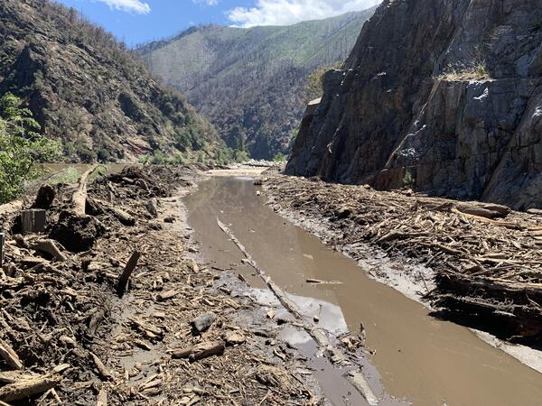
Debris-flow deposits downstream of the 2022 Pipeline Fire burn scar, north of Flagstaff, Arizona
Debris-flow deposits downstream of the 2022 Pipeline Fire burn scar, north of Flagstaff, ArizonaDebris-flow deposits downstream of the 2022 Pipeline Fire burn scar, north of Flagstaff, Arizona.
Debris-flow deposits downstream of the 2022 Pipeline Fire burn scar, north of Flagstaff, Arizona
Debris-flow deposits downstream of the 2022 Pipeline Fire burn scar, north of Flagstaff, ArizonaDebris-flow deposits downstream of the 2022 Pipeline Fire burn scar, north of Flagstaff, Arizona.

Chaos Canyon landslide deposits
The June 28, 2022, Chaos Canyon debris slide with main features labeled. Horizontal distance from the middle of headscarp to the middle of toe is about 585 m. North is towards the right side of the photograph.
The June 28, 2022, Chaos Canyon debris slide with main features labeled. Horizontal distance from the middle of headscarp to the middle of toe is about 585 m. North is towards the right side of the photograph.

Chaos Canyon deposits
View looking down the debris slide to the pool of mud accumulating behind the ridge of dirty, snow boulders. North is towards the left of the photograph.
View looking down the debris slide to the pool of mud accumulating behind the ridge of dirty, snow boulders. North is towards the left of the photograph.

House destroyed by postfire debris flow in the Muckamuck Fire, Washington
House destroyed by postfire debris flow in the Muckamuck Fire, WashingtonOn July 4, 2022, intense rainfall triggered this debris flow that damaged a home in the 2021 Muckamuck Fire in north-central Washington.
House destroyed by postfire debris flow in the Muckamuck Fire, Washington
House destroyed by postfire debris flow in the Muckamuck Fire, WashingtonOn July 4, 2022, intense rainfall triggered this debris flow that damaged a home in the 2021 Muckamuck Fire in north-central Washington.
Dixie fire debris-flow deposit
Debris flow deposit in the North Fork Feather River, Plumas County, CA near the Dixie burn area.
Debris flow deposit in the North Fork Feather River, Plumas County, CA near the Dixie burn area.
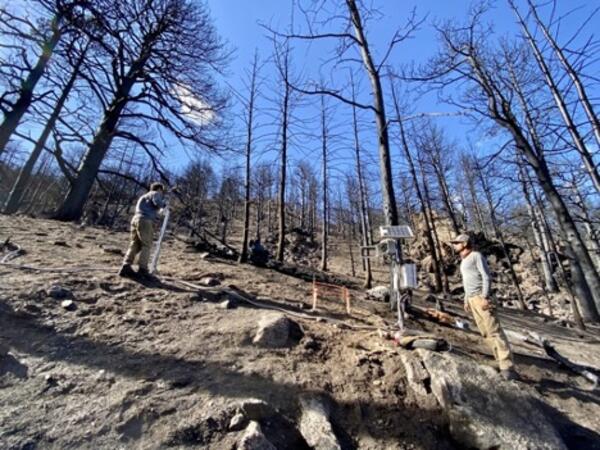
Calwood.jpg
The USGS “Heil Ranch” site is located in the Arapahoe-Roosevelt National Forest in Colorado. The site consists of instrumentation monitoring the rainfall and soil moisture.
The USGS “Heil Ranch” site is located in the Arapahoe-Roosevelt National Forest in Colorado. The site consists of instrumentation monitoring the rainfall and soil moisture.

Screenshot from the Puerto Rico Landslide Susceptibility Map
Screenshot from the Puerto Rico Landslide Susceptibility MapThe USGS Puerto Rico Landslide Susceptibility Map provides an interactive tool to assess landslide risk in Puerto Rico from low susceptibility to extremely high.
Screenshot from the Puerto Rico Landslide Susceptibility Map
Screenshot from the Puerto Rico Landslide Susceptibility MapThe USGS Puerto Rico Landslide Susceptibility Map provides an interactive tool to assess landslide risk in Puerto Rico from low susceptibility to extremely high.

Adjuntas, Puerto Rico Landslide Monitoring Station
Adjuntas, Puerto Rico Landslide Monitoring StationCompleted landslide monitoring station at Adjuntas, Puerto Rico among the palms.
Adjuntas, Puerto Rico Landslide Monitoring Station
Adjuntas, Puerto Rico Landslide Monitoring StationCompleted landslide monitoring station at Adjuntas, Puerto Rico among the palms.
Adjuntas, Puerto Rico Landslide Monitoring Station
Adjuntas, Puerto Rico Landslide Monitoring StationCompleted landslide monitoring station at Adjuntas, Puerto Rico among the palms. One of the sites in the Puerto Rico Landslide Monitoring Network.
Adjuntas, Puerto Rico Landslide Monitoring Station
Adjuntas, Puerto Rico Landslide Monitoring StationCompleted landslide monitoring station at Adjuntas, Puerto Rico among the palms. One of the sites in the Puerto Rico Landslide Monitoring Network.

Adjuntas, Puerto Rico Landslide Monitoring Station
Adjuntas, Puerto Rico Landslide Monitoring StationKelli Baxstrom wires sensors to a datalogger after sensors are installed underground at the Adjuntas, Puerto Rico, landslide monitoring site, part of the Puerto Rico Landslide Monitoring Network.
Adjuntas, Puerto Rico Landslide Monitoring Station
Adjuntas, Puerto Rico Landslide Monitoring StationKelli Baxstrom wires sensors to a datalogger after sensors are installed underground at the Adjuntas, Puerto Rico, landslide monitoring site, part of the Puerto Rico Landslide Monitoring Network.