
On January 10, 2005, a landslide struck the community of La Conchita in Ventura County, California, destroying or seriously damaging 36 houses and killing 10 people. For a USGS rerpot on this event, please see USGS Open-file report, "Landslide Hazards at La Conchita, California."
Images
Browse our photos of landslide research and post-landslide investigations.
Filter Total Items: 266

2005 Landslide in La Conchita, CA
On January 10, 2005, a landslide struck the community of La Conchita in Ventura County, California, destroying or seriously damaging 36 houses and killing 10 people. For a USGS rerpot on this event, please see USGS Open-file report, "Landslide Hazards at La Conchita, California."

Rock-Fall Estimating
Geologist Ed Harp estimates rock-fall susceptibility in American Fork Canyon, UT.
Geologist Ed Harp estimates rock-fall susceptibility in American Fork Canyon, UT.

Rock-Fall Estimating
Geologist Ed Harp estimates rock-fall susceptibility in American Fork Canyon, UT.
Geologist Ed Harp estimates rock-fall susceptibility in American Fork Canyon, UT.

Early Warning System
Cable Canyon was burned during the Grand Prix-Old Fire of 2003 and experienced debris flows and floods in response to the December 25, 2003 rainstorm. Two people lost their lives at this site.
Cable Canyon was burned during the Grand Prix-Old Fire of 2003 and experienced debris flows and floods in response to the December 25, 2003 rainstorm. Two people lost their lives at this site.

Rio Grande at Boquillas Canyon Entrance, Big Bend National Park
Rio Grande at Boquillas Canyon Entrance, Big Bend National ParkView of the Rio Grande River at the entrance to Boquillas Canyon.
Rio Grande at Boquillas Canyon Entrance, Big Bend National Park
Rio Grande at Boquillas Canyon Entrance, Big Bend National ParkView of the Rio Grande River at the entrance to Boquillas Canyon.

Landslide Sampling
Scientist Jonathan Godt samples a landslide headscarp in Alameda County, CA.
Scientist Jonathan Godt samples a landslide headscarp in Alameda County, CA.

Seattle Area Monitoring site
Photograph showing a house that was damaged by a 1997 landslide along Perkins Lane in Seattle, Washington.
Photograph showing a house that was damaged by a 1997 landslide along Perkins Lane in Seattle, Washington.

Seattle Area Monitoring site
Photograph showing the scar left by a landslide on a hillside above the Burlington Northern Santa Fe Railway in Everett, Washington.
Photograph showing the scar left by a landslide on a hillside above the Burlington Northern Santa Fe Railway in Everett, Washington.

Catastrophic Landslide
The Mameyes, Puerto Rico, landslide, 1985. This landslide destroyed 120 houses and killed at least 129 people. The catastrophic slide was triggered by a tropical storm that produced extremely heavy rainfall.
The Mameyes, Puerto Rico, landslide, 1985. This landslide destroyed 120 houses and killed at least 129 people. The catastrophic slide was triggered by a tropical storm that produced extremely heavy rainfall.

Significant Landslide Events in the United States
The April 1983 landslide at Thistle, Utah, created a 200-ft-high (60-m-high) blockage of Spanish Fork canyon that caused disastrous flooding of the Thistle creek and Soldier Creek valleys upstream. The flooding caused by the landslide required relocation of a major highway and railway. An emergency spillway and diversion tunnels were constructed to drain
The April 1983 landslide at Thistle, Utah, created a 200-ft-high (60-m-high) blockage of Spanish Fork canyon that caused disastrous flooding of the Thistle creek and Soldier Creek valleys upstream. The flooding caused by the landslide required relocation of a major highway and railway. An emergency spillway and diversion tunnels were constructed to drain
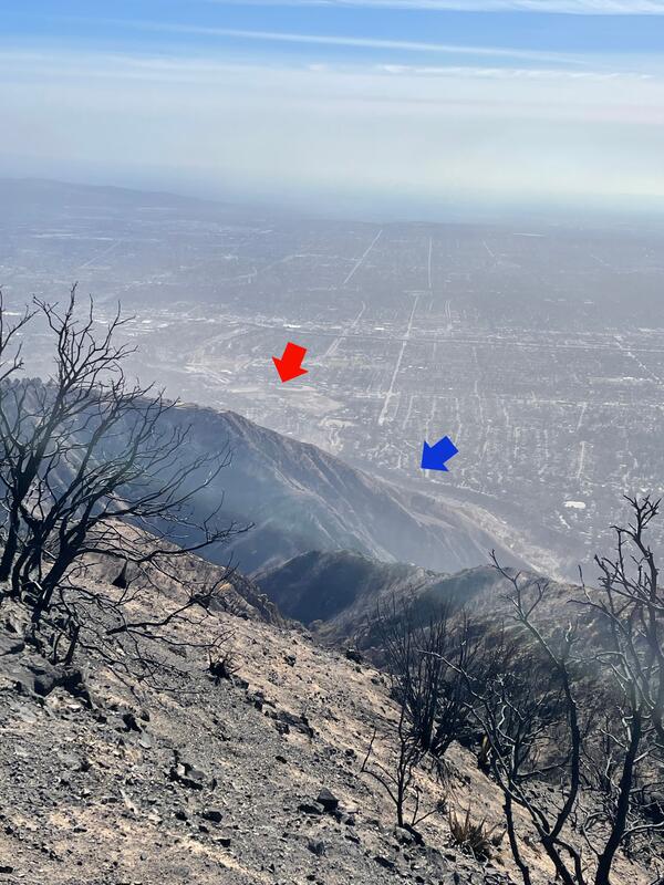
Aerial view of Eaton Wash and Eaton Wash dam
Eaton Wash (blue arrow) is a channel that flows along the mountain front and empties into the Eaton Wash Reservoir (red arrow). The Eaton Wash Dam and Eaton Wash Reservoir help to control flood waters and trap sediment that shed from the range front during the rainy season in southern California.
Eaton Wash (blue arrow) is a channel that flows along the mountain front and empties into the Eaton Wash Reservoir (red arrow). The Eaton Wash Dam and Eaton Wash Reservoir help to control flood waters and trap sediment that shed from the range front during the rainy season in southern California.

Debris Flow in Action
A debris flow exceeding a meter in depth rushes towards the monitoring station used to measure basal force and other flow properties.
Captured by automated monitoring camera.
A debris flow exceeding a meter in depth rushes towards the monitoring station used to measure basal force and other flow properties.
Captured by automated monitoring camera.

Deforested Slope, Cayaguas Watershed
An example of a deforested slope in the Cayaguas watershed, eastern Puerto Rico. Such areas are more susceptible to landslides.
An example of a deforested slope in the Cayaguas watershed, eastern Puerto Rico. Such areas are more susceptible to landslides.

Debris Flow Research
Scientists Jonathan Godt and Rex Baum examine a fresh debris-flow deposit near Buena Vista, CO.
Scientists Jonathan Godt and Rex Baum examine a fresh debris-flow deposit near Buena Vista, CO.