
This is a cover photo for the Landslide Basics node with the title next to an illustration of a landslide.
Images
Browse our photos of landslide research and post-landslide investigations.
Filter Total Items: 266

Landslide Basics Cover Photo
This is a cover photo for the Landslide Basics node with the title next to an illustration of a landslide.
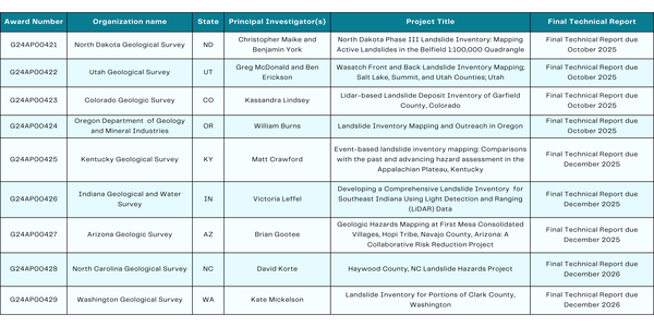
External Grant Projects Table
Table displaying the USGS Landslide external grant recipients. The information for each recipient organization, project title, and principal investigators is included.
Table displaying the USGS Landslide external grant recipients. The information for each recipient organization, project title, and principal investigators is included.

Landslide Basics Thumbnail Image
Text "Landslide Basics" on green background, infographic made for landslide basics page
Text "Landslide Basics" on green background, infographic made for landslide basics page

2024 South Fork postfire flows
Flooding and debris flows during rain events following the 2024 South Fork Fire near Ruidoso, New Mexico.
Flooding and debris flows during rain events following the 2024 South Fork Fire near Ruidoso, New Mexico.
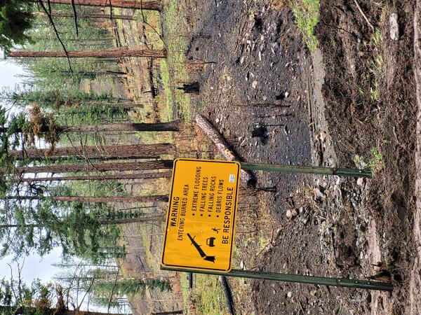
2024 South Fork Fire burn area warning sign
A road sign in the 2024 South Fork Fire, Lincoln National Forest, New Mexico warns of flooding and debris flow hazards. Partially burned trees are visible on the hillslope in the image background. Mud and other debris moved down the slope and were deposited along the road, near the base of the sign.
A road sign in the 2024 South Fork Fire, Lincoln National Forest, New Mexico warns of flooding and debris flow hazards. Partially burned trees are visible on the hillslope in the image background. Mud and other debris moved down the slope and were deposited along the road, near the base of the sign.

Postfire debris flows
Fast-moving, highly destructive debris flows triggered by intense rainfall are one of the most dangerous post-fire hazards. The risk of floods and debris flows after fires increases due to vegetation loss and soil exposure. Cases of sudden and deadly debris flow are well documented along the western United States, particularly in Southern California.
Fast-moving, highly destructive debris flows triggered by intense rainfall are one of the most dangerous post-fire hazards. The risk of floods and debris flows after fires increases due to vegetation loss and soil exposure. Cases of sudden and deadly debris flow are well documented along the western United States, particularly in Southern California.

Redwood recovery in the 2020 CZU Lightning Complex burn area
Redwood recovery in the 2020 CZU Lightning Complex burn areaTimelapse photography of vegetation recovery following the 2020 CZU Lightning Complex in the Santa Cruz Mountains of northern California. This two-year image sequence begins four and a half months after the wildfire was contained. Time between photographs is approximately two weeks.

Chaparral recovery in the 2020 CZU Lightning Complex burn area
Chaparral recovery in the 2020 CZU Lightning Complex burn areaTimelapse photography of vegetation recovery following the 2020 CZU Lightning Complex in the Santa Cruz Mountains of northern California. This two-year image sequence begins four and a half months after the wildfire was contained. Time between photographs is approximately two weeks.

Los Lomas Landslide Monitoring Station
A landslide monitoring station within the footprint of the 2016 Fish Fire in the San Gabriel Mountains of southern California. The station collects surface and subsurface data to monitor and detect changes in local hillslope hydrologic conditions.
A landslide monitoring station within the footprint of the 2016 Fish Fire in the San Gabriel Mountains of southern California. The station collects surface and subsurface data to monitor and detect changes in local hillslope hydrologic conditions.

The USGS Postfire Landslide Monitoring Station “Maria Ygnacio” within the Los Padres National Forest, California.
The USGS Postfire Landslide Monitoring Station “Maria Ygnacio” within the Los Padres National Forest, California.The USGS Postfire Landslide Monitoring Station “Maria Ygnacio” is located within the Los Padres National Forest in the Santa Ynez Mountains of southern California. The site consists of surface and subsurface instrumentation that is monitoring the hillslope shown in this image.

Añasco, Puerto Rico Landslide Monitoring Station in Progress
Añasco, Puerto Rico Landslide Monitoring Station in ProgressUniversity of Puerto Rico, Mayagüez and USGS scientists working on the Añasco monitoring station
Añasco, Puerto Rico Landslide Monitoring Station in Progress
Añasco, Puerto Rico Landslide Monitoring Station in ProgressUniversity of Puerto Rico, Mayagüez and USGS scientists working on the Añasco monitoring station

Grazing Cow - Añasco, Puerto Rico Monitoring Station
Grazing Cow - Añasco, Puerto Rico Monitoring StationSituated on a vegetated hillslope surrounded by cattle, is the Añasco monitoring station. A fence was built around the station to keep the grazing cattle from damaging any of the station components

Añasco, Puerto Rico Landslide Monitoring Station
Stephen Hughes, Gabriel Colón, and Ednet López stand on hillslope next to completed landslide monitoring station at Añasco, Puerto Rico
Stephen Hughes, Gabriel Colón, and Ednet López stand on hillslope next to completed landslide monitoring station at Añasco, Puerto Rico

Steep, rugged terrain in the area burned by the 2009 Station Fire.
Steep, rugged terrain in the area burned by the 2009 Station Fire.Steep, rugged terrain in the area burned by the 2009 Station Fire, Angeles National Forest, California. This photo was taken approximately 14 years after the wildfire, and the vegetation has fully recovered. Note the steep slopes in the background of the image.
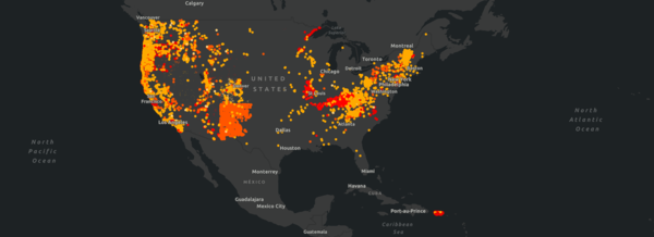
U.S. Landslide Inventory, September 2023
Screenshot from the U.S. Landslide Inventory web application, an openly accessible, centralized map of existing information on landslide occurrence across the entire U.S
Screenshot from the U.S. Landslide Inventory web application, an openly accessible, centralized map of existing information on landslide occurrence across the entire U.S

Charlie Miles
Charlie Miles performing field work on the Alaskan Gyre at the Prince William Sound, Alaska
Charlie Miles performing field work on the Alaskan Gyre at the Prince William Sound, Alaska

Types of Landslides
TYPES OF LANDSLIDES

Creep
Creep is the imperceptibly slow, steady, downward movement of slope-forming soil or rock. Movement is caused by shear stress sufficient to produce permanent deformation, but too small to produce shear failure.
Creep is the imperceptibly slow, steady, downward movement of slope-forming soil or rock. Movement is caused by shear stress sufficient to produce permanent deformation, but too small to produce shear failure.

Debris Avalanche
Debris avalanche: This is a variety of very rapid to extremely rapid debris flow.
Debris avalanche: This is a variety of very rapid to extremely rapid debris flow.

Rockfall
Rockfalls are abrupt movements of masses of geologic materials, such as rocks and boulders, which become detached from steep slopes or cliffs. Separation occurs along discontinuities such as fractures, joints, and bedding planes, and movement occurs by free-fall, bouncing, and rolling.
Rockfalls are abrupt movements of masses of geologic materials, such as rocks and boulders, which become detached from steep slopes or cliffs. Separation occurs along discontinuities such as fractures, joints, and bedding planes, and movement occurs by free-fall, bouncing, and rolling.

Earthflow
Earthflows have a characteristic "hourglass" shape. The slope material liquefies and runs out, forming a bowl or depression at the head. The flow itself is elongated and usually occurs in fine-grained materials or clay-bearing rocks on moderate slopes and under saturated conditions. However, dry flows of granular material are also possible.
Earthflows have a characteristic "hourglass" shape. The slope material liquefies and runs out, forming a bowl or depression at the head. The flow itself is elongated and usually occurs in fine-grained materials or clay-bearing rocks on moderate slopes and under saturated conditions. However, dry flows of granular material are also possible.