



Landslides by Location
Landslides by Location
Research studies on past landslides and areas of potential future landslides.
Filter Total Items: 14
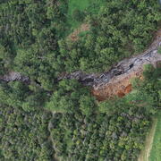
2026 Hurricane Lala Landslide Hazards
Flooding and debris flows occurred on the south side of Hawai‘i Island during Hurricane Lala, which passed near the island on 15 –17 August 2026. The hurricane produced high rainfall rates, (e.g., 32.1 inches of daily rainfall recorded at the Laupāhoehoe station) (University of Hawai’i News, 2026). Catastrophic flash flooding, debris flows following the storm, specifically near Na‘ālehu, and...
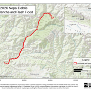
2026 Nepal Debris Avalanche and Flash Flood
On Wednesday morning (local time), 26 August 2026, a catastrophic debris flow and flood was likely triggered by rapid slope failure involving a glacier in Lāṅṭāṇ National Park, Nepal, near the border with China. This debris flow and flooding travelled nearly 100 km and impacted populated areas downstream along the Lende Kholā and Trishuli̇̄ Kholā rivers, including the Rasuwāgaḍhi̇̄ border post...

Rainfall and Landslides in Northern California
A summary of recent and past landslides and debris flows caused by rainfall in northern California, and links to current shallow landslide monitoring.
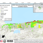
2026 Venezuela Sequence Earthquake-Triggered Landslide Hazards
On Wednesday, June 24th, 2026, a pair of earthquakes of Magnitude 7.2 and Magnitude 7.5 occurred in northern Venezuela, west of Caracas. The U.S. Geological Survey (USGS) Ground Failure product estimated that landslides triggered by this earthquake would likely be significant in number and/or spatial extent. This landslide event page serves to communicate timely science information to our partners...
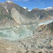
2025 Tracy Arm Landslide-Generated Tsunami
A landslide above the toe of the South Sawyer Glacier failed into the waters of Tracy Arm, south of Juneau, Alaska, producing a tsunami on Sunday, August 10th, 2025, at 05:26 AKDT / 13:26 UTC. No injuries or fatalities have been reported. This page may be updated as more information about the event is obtained. Steep, mountainous landslide areas are inherently unstable and will continue to change...

2024 Hurricane Helene Landslide Hazards
Hurricane Helene produced widespread damaging, and in some cases, deadly landslides. Hurricane Helene made landfall in Florida as a Category 4 storm on Thursday, September 26th, 2024. The hurricane continued across the southern Appalachian Mountains producing record rainfall and wind gusts, damaging flooding, and triggering over 2000 landslides. This page provides information about the extent and...

2024 Pedersen Glacier Lagoon Landslide-Generated Tsunami
A 4.6-million-cubic-meter (equivalent to over 184 Olympic-sized swimming pools) landslide produced a tsunami in Pedersen Glacier lagoon, southwest of Seward, Alaska on Wednesday, August 7th, 2024, at approximately 04:55 AKDT / 12:55 UTC. Surveying indicated that the landslide generated tsunami runup of at least 17 meters (approx. 56 ft) in the upper Pedersen Glacier lagoon*, reducing to about one...

Puerto Rico Natural Hazards: Landslides | Peligros naturales de Puerto Rico: Deslizamientos de tierra
The Landslide Hazards Program from USGS works to help reduce the impact of landslides to people and infrastructure by furthering our understanding of causes of ground failure and by recommending strategies for risk mitigation. In Puerto Rico, USGS researchers have rigorously studied rainfall-induced landslides to provide maps that depict landslide susceptibility. Educational materials that...

Rainfall-Induced Landslides in Puerto Rico
In September 2017 Hurricane María triggered more than 70,000 landslides across Puerto Rico that caused loss of life and widespread damage to transportation, communication, and power-supply infrastructure, and to other public and private property.

Landslides Triggered by the 2020 Puerto Rico Earthquake Sequence
A magnitude 6.4 earthquake occurred near Barrio Indios, Guayanilla, Puerto Rico on January 7, 2020. A study of the triggered landslides is ongoing.
Puerto Rico Landslide Hazard Mitigation Project
The University of Puerto Rico-Mayagüez and USGS produced a landslide hazard map for the main island of Puerto Rico following Hurricane Maria. This map is today used by planners for land use decisions and emergency managers for hazard mitigation plans. To reduce loss from future landslides, the USGS and the University of Puerto Rico-Mayagüez instrumented 15 slopes across the main island and share...

Preliminary Analysis of Satellite Imagery and Seismic Observations of the Nuugaatsiaq Landslide and Tsunami, Greenland
Disclaimer This information is preliminary or provisional and is subject to revision. It is being provided to meet the need for timely science to assess ongoing hazards. The information has not received final approval by the U.S. Geological Survey (USGS) and is provided on the condition that neither the USGS nor the U.S. Government shall be held liable for any damages resulting from the authorized...