
A USGS storm-tide sensor, deployed in advance of Hurricane Florence's landfall. The sensors are housed in vented steel pipes a few inches wide and about a foot long. They are being installed on bridges, piers, and other structures that have a good chance of surviving the storm.
Images
Images from the Southeast Region.
Filter Total Items: 398

USGS Storm-Tide Sensor for Hurricane Florence
A USGS storm-tide sensor, deployed in advance of Hurricane Florence's landfall. The sensors are housed in vented steel pipes a few inches wide and about a foot long. They are being installed on bridges, piers, and other structures that have a good chance of surviving the storm.

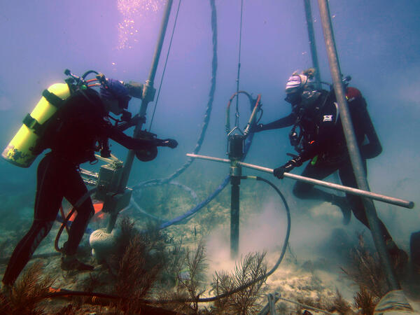
Retrieving Seismic Airguns
USGS personnel on the deck of the R/V Hugh R.
USGS personnel on the deck of the R/V Hugh R.

Erosion has taken a toll on this Keys coral
A reef in the Florida Keys National Marine Sanctuary with little living coral and extensive bioerosion. Photo taken under research permit number FKNMS-2016-085-A1. Credit: USGS, Ilsa Kuffner.
A reef in the Florida Keys National Marine Sanctuary with little living coral and extensive bioerosion. Photo taken under research permit number FKNMS-2016-085-A1. Credit: USGS, Ilsa Kuffner.
USGS scientists drill a coral-reef core in the Florida Keys
USGS scientists drill a coral-reef core in the Florida KeysResearch Oceanographer Lauren Toth and student volunteer Liz Whitcher drill a coral-reef core from a reef off Key West, Florida, in the Florida Keys National Marine Sanctuary. Photo taken under research permit FKNMS-2015-058. Credit: Anastasios Stathakopoulos, USGS.

Like many Keys corals, this one has no new growth
A modern coral reef in Dry Tortugas National Park. There is little living coral and high rates of bioerosion. Photo taken under research permit number DRTO-2018-SCI-0005. Credit: Lauren Toth, USGS
A modern coral reef in Dry Tortugas National Park. There is little living coral and high rates of bioerosion. Photo taken under research permit number DRTO-2018-SCI-0005. Credit: Lauren Toth, USGS
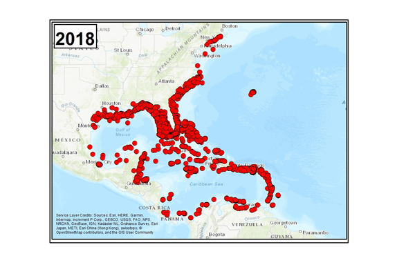
1985-2018 Lionfish Invasion
Lionfish invasion (1985-2018). Lionfish invaded US Atlantic coastal waters, the Caribbean Sea, and the Gulf of Mexico with unprecedented, alarming speed. Though reports of sightings date back to the 1980s, it is only recently that the species has exploded in numbers and range.
Lionfish invasion (1985-2018). Lionfish invaded US Atlantic coastal waters, the Caribbean Sea, and the Gulf of Mexico with unprecedented, alarming speed. Though reports of sightings date back to the 1980s, it is only recently that the species has exploded in numbers and range.

Can you hear me now?
Steve Suttles (USGS) uses a radio to determine if an Acoustic Backscatter sensor (white circle) is still operating at the end of the deployment.
Steve Suttles (USGS) uses a radio to determine if an Acoustic Backscatter sensor (white circle) is still operating at the end of the deployment.

Oh Buoy!
crew of the R/V Savannah recover the buoy deployed at the offshore site to record meteorological data.
crew of the R/V Savannah recover the buoy deployed at the offshore site to record meteorological data.

Quadpod Recovery
USGS team and R/V Savannah crew prepare to lower the quadpod deployed at the nearshore site onto the deck during recovery operations. Note all the hairy encrusting organisms that grew in 3 months and how close to the shoreline the ship is.
USGS team and R/V Savannah crew prepare to lower the quadpod deployed at the nearshore site onto the deck during recovery operations. Note all the hairy encrusting organisms that grew in 3 months and how close to the shoreline the ship is.

Conglomerates, Sycamore Sand at Hammetts Crossing, Travis Cty, Texas
Conglomerates, Sycamore Sand at Hammetts Crossing, Travis Cty, TexasConglomerates within the Sycamore Sand at Hammetts Crossing, Travis County, Texas (photograph by Allan K. Clark, U.S. Geological Survey, February 27, 2018).
U.S. Geological Survey Scientific Investigations Map 3418, https://doi.org/10.3133/sim3418

Fieldwork on Florida Bay Islands
A USGS researcher conducts fieldwork on Buttonwood Key, an island in Florida Bay, to determine the impacts of Hurricane Irma. The storm left thick deposits of mud on the island, which are being measured, sampled and photographed. Many of the islands in Florida Bay have open mudflats in the center, surrounded by mangroves on the perimeter.
A USGS researcher conducts fieldwork on Buttonwood Key, an island in Florida Bay, to determine the impacts of Hurricane Irma. The storm left thick deposits of mud on the island, which are being measured, sampled and photographed. Many of the islands in Florida Bay have open mudflats in the center, surrounded by mangroves on the perimeter.

USGS St. Petersburg Coastal and Marine Science Center
USGS St. Petersburg Coastal and Marine Science CenterUSGS St. Petersburg Coastal and Marine Science Center
USGS St. Petersburg Coastal and Marine Science Center
USGS St. Petersburg Coastal and Marine Science CenterUSGS St. Petersburg Coastal and Marine Science Center

Field water-level monitoring gage EDEN 13
Field water-level monitoring gage EDEN 13. Photograph by Michael Oliver, U.S. Geological Survey.
U.S. Geological Survey Fact Sheet 2017–3069
Version 1.1, January 2018
Field water-level monitoring gage EDEN 13. Photograph by Michael Oliver, U.S. Geological Survey.
U.S. Geological Survey Fact Sheet 2017–3069
Version 1.1, January 2018

Berm at Jim Foot Key, Florida (2018)
In Photo: The red circle indicates the same position as shown in the April 2014 photo. The mangroves have lost all their leaves and the berm is significantly thinner following the storm.
In Photo: The red circle indicates the same position as shown in the April 2014 photo. The mangroves have lost all their leaves and the berm is significantly thinner following the storm.

Examination of a Black Carp
A USGS intern preparing to examine a black carp captured from the wild. This fish and others were examined for various aspects of their life history, including age, the environments in which they have lived and whether they were naturally reproduced. Credit: USGS.
A USGS intern preparing to examine a black carp captured from the wild. This fish and others were examined for various aspects of their life history, including age, the environments in which they have lived and whether they were naturally reproduced. Credit: USGS.

Estimated and measured bathymetry offshore of Madeira Beach, Florida
Estimated and measured bathymetry offshore of Madeira Beach, FloridaEstimated and measured ocean depths (bathymetry) from Madeira Beach, Florida. Each panel shows same geographic area. m = meters. Left: Snapshot transformed from original oblique camera view to overhead “map” view. Middle: Bathymetry estimated by applying cBathy algorithm to July 2017 video imagery. Right: Bathymetry measured with sonar in February 2017.

Elkhorn coral in Biscayne National Park
The CMHRP is testing the calcification rates of different genetic strains of threatened Elkhorn coral (Acropora palmata) to advise local and Federal agencies engaged in coral reef restoration.
The CMHRP is testing the calcification rates of different genetic strains of threatened Elkhorn coral (Acropora palmata) to advise local and Federal agencies engaged in coral reef restoration.

A Rapid Deployment Gauge in Puerto Rico
This USGS Rapid Deployment Gauge was installed near Morovis, Puerto Rico, to monitor the Río Grande de Manatí after Hurricane Maria destroyed the permanent streamgage which typically monitors the river. USGS photo.
This USGS Rapid Deployment Gauge was installed near Morovis, Puerto Rico, to monitor the Río Grande de Manatí after Hurricane Maria destroyed the permanent streamgage which typically monitors the river. USGS photo.

Video camera atop a hotel in Madeira Beach, Florida
Video camera atop a hotel in Madeira Beach, FloridaVideo camera atop a hotel in Madeira Beach, Florida.
Video camera atop a hotel in Madeira Beach, Florida
Video camera atop a hotel in Madeira Beach, FloridaVideo camera atop a hotel in Madeira Beach, Florida.

LS Preliminary Puerto Rico
Excerpt of satellite image showing landslide impacts to roads, agriculture, and a reservoir in the Lares Municipality. Points identify the approximate location of roads visibly impacted by landslides. Image filename contains approximate latitude and longitude of this impact location.
Excerpt of satellite image showing landslide impacts to roads, agriculture, and a reservoir in the Lares Municipality. Points identify the approximate location of roads visibly impacted by landslides. Image filename contains approximate latitude and longitude of this impact location.

Low dunes near Cape Canaveral launch pads often overwash during storms
Low dunes near Cape Canaveral launch pads often overwash during stormsLow dunes near Cape Canaveral launch pads 39A and 39B often overwash during storm events, transporting sand landward. Critical infrastructure may be buried or flooded. In addition, significant landward transport of sand may lead to extensive shoreline erosion.