
Source to Outcome Research Framework that was updated from the 2022 Source to Receptor Research Framework
Stephanie Gordon
Stephanie is a Physical Scientist at the Eastern Ecological Science Center in Kearneysville, WV.
Stephanie started with the USGS as a volunteer with the Eastern Geographic Science Center in 2015 working on the Sediment-bound Contaminant Resiliency and Response (SCoRR) project and has since worked on a diverse variety of projects. Her research includes using geospatial tools to quantify landscape contaminant sources and understand relationships to biological endpoints. This work has focused on landscape sources of endocrine disrupting compounds in the Chesapeake Bay Watershed and their relationship to fish health and water quality; data management and mapping support for USGS Chesapeake Bay activities; and includes similar work on harmful algal blooms and shallow well contamination at national and regional scales.
Science and Products
Evaluating the Risks of Tire-Derived Compounds to Fish in the Chesapeake Bay Watershed
Tires contain a chemical known as 6PPD which prevents them from quickly breaking down. Microscopic tire particles, generated mainly from the friction of tires on roads, release 6PPD-quinone (6PPDQ) when they come into contact with oxygen. During precipitation events, 6PPDQ can be washed off roads, harming fish in nearby waterways. In response to requests from fishery managers, the USGS is studying...
Geospatial Analyses and Applications Core Technology Team
About the Research The Geospatial Analyses and Applications Core Technology Team (CTT) as part of the Environmental Health Program collaborates with teams across USGS to develop and apply geospatial analytical methods to answer broad-scale questions about source-sink and cause-effect relationships between contaminants and vulnerable communities.

USGS Scientists Develop an Interactive Mapping Tool to Visualize PFAS in Tap Water
A new interactive dashboard is available to visualize PFAS measurements for 716 tap water samples collected at select sites across the nation between 2016 and 2021 from private and public supplies.

Agricultural best management practices can improve water quality and conditions for fisheries in the Chesapeake Bay Watershed
Issue Partners in the Chesapeake Bay Program (CBP) are implementing best management practices (BMPs) to prevent nutrient and sediment from entering waterways across the Chesapeake watershed and reduce loads to the Bay. In addition to reducing nutrients, CBP partners want to better understand how BMPs can provide additional benefits for addressing toxic contaminants, such as pesticides, hormones...

USGS Integrates Findings about Endocrine-Disrupting Compounds in the Chesapeake Watershed
Issue: Studies in the Chesapeake Bay Watershed have documented the exposure of fish to toxic contaminants including endocrine-disrupting compounds (EDCs) - compounds which can alter normal hormonal function in organisms. Given the importance of fisheries to the economic and environmental health of the Watershed, observed endocrine disruption and fish kills in the Watershed have raised public and...

Endocrine Disrupting Compounds in the Chesapeake Bay Watershed Science Team
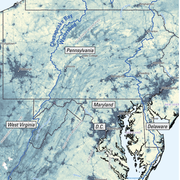
The Chesapeake Bay is the largest estuary in the United States and provides critical resources to fish, wildlife and people. For more than a decade, recreational fish species have been plagued with skin lesions and intersex conditions (the presence of male and female sex characteristics in the same fish) that biologists attributed to exposures to endocrine disrupting chemicals (EDCs)...

Source to Outcome Research Framework
Source to Outcome Research Framework that was updated from the 2022 Source to Receptor Research Framework

Juvenile Coho Salmon (Oncorhynchus kisutch) Laboratory Studies.
Juvenile Coho Salmon (Oncorhynchus kisutch) Laboratory Studies.Juvenile Coho salmon (Oncorhynchus kisutch) behavior is assessed following exposure to 6PPD-quinone, a derivative of the compound 6PPD which is used in tires to prevent wear.
Coho Salmon 6PPD-Q Exposure Study
Juvenile Coho salmon (Oncorhynchus kisutch) exhibiting abnormal behaviors associated with exposure to 6PPD-quinone, a derivative of the compound 6PPD which is used in tires to prevent wear.
Juvenile Coho salmon (Oncorhynchus kisutch) exhibiting abnormal behaviors associated with exposure to 6PPD-quinone, a derivative of the compound 6PPD which is used in tires to prevent wear.

USGS Studies on Contaminants in Drinking Water
Diagram depicting the sources of drinking water (surface water and groundwater), known and potential sources of contaminants introduced to drinking water (urban and agricultural land use, runoff, infiltration, waste, and wastewater sources) and routes of potential exposure from the point of use (drinking water in the home, at work, and from bottled water).
Diagram depicting the sources of drinking water (surface water and groundwater), known and potential sources of contaminants introduced to drinking water (urban and agricultural land use, runoff, infiltration, waste, and wastewater sources) and routes of potential exposure from the point of use (drinking water in the home, at work, and from bottled water).
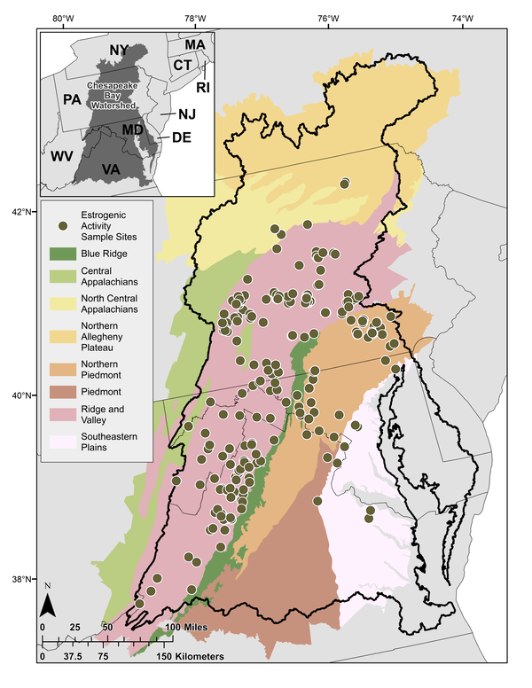
Map of surface water sampling locations in the Chesapeake Bay Watershed
Map of surface water sampling locations in the Chesapeake Bay WatershedSurface water sampling locations (n = 244) in the Chesapeake Bay Watershed shown with EPA Level 3 Ecoregions.
Map of surface water sampling locations in the Chesapeake Bay Watershed
Map of surface water sampling locations in the Chesapeake Bay WatershedSurface water sampling locations (n = 244) in the Chesapeake Bay Watershed shown with EPA Level 3 Ecoregions.
Science and Products
Evaluating the Risks of Tire-Derived Compounds to Fish in the Chesapeake Bay Watershed
Tires contain a chemical known as 6PPD which prevents them from quickly breaking down. Microscopic tire particles, generated mainly from the friction of tires on roads, release 6PPD-quinone (6PPDQ) when they come into contact with oxygen. During precipitation events, 6PPDQ can be washed off roads, harming fish in nearby waterways. In response to requests from fishery managers, the USGS is studying...
Geospatial Analyses and Applications Core Technology Team
About the Research The Geospatial Analyses and Applications Core Technology Team (CTT) as part of the Environmental Health Program collaborates with teams across USGS to develop and apply geospatial analytical methods to answer broad-scale questions about source-sink and cause-effect relationships between contaminants and vulnerable communities.
Geospatial Analyses and Applications Core Technology Team
About the Research The Geospatial Analyses and Applications Core Technology Team (CTT) as part of the Environmental Health Program collaborates with teams across USGS to develop and apply geospatial analytical methods to answer broad-scale questions about source-sink and cause-effect relationships between contaminants and vulnerable communities.
Geospatial Analyses and Applications Core Technology Team
About the Research The Geospatial Analyses and Applications Core Technology Team (CTT) as part of the Environmental Health Program collaborates with teams across USGS to develop and apply geospatial analytical methods to answer broad-scale questions about source-sink and cause-effect relationships between contaminants and vulnerable communities.
USGS Scientists Develop an Interactive Mapping Tool to Visualize PFAS in Tap Water
A new interactive dashboard is available to visualize PFAS measurements for 716 tap water samples collected at select sites across the nation between 2016 and 2021 from private and public supplies.
Agricultural best management practices can improve water quality and conditions for fisheries in the Chesapeake Bay Watershed
Issue Partners in the Chesapeake Bay Program (CBP) are implementing best management practices (BMPs) to prevent nutrient and sediment from entering waterways across the Chesapeake watershed and reduce loads to the Bay. In addition to reducing nutrients, CBP partners want to better understand how BMPs can provide additional benefits for addressing toxic contaminants, such as pesticides, hormones...
USGS Integrates Findings about Endocrine-Disrupting Compounds in the Chesapeake Watershed
Issue: Studies in the Chesapeake Bay Watershed have documented the exposure of fish to toxic contaminants including endocrine-disrupting compounds (EDCs) - compounds which can alter normal hormonal function in organisms. Given the importance of fisheries to the economic and environmental health of the Watershed, observed endocrine disruption and fish kills in the Watershed have raised public and...
Endocrine Disrupting Compounds in the Chesapeake Bay Watershed Science Team
The Chesapeake Bay is the largest estuary in the United States and provides critical resources to fish, wildlife and people. For more than a decade, recreational fish species have been plagued with skin lesions and intersex conditions (the presence of male and female sex characteristics in the same fish) that biologists attributed to exposures to endocrine disrupting chemicals (EDCs)...
Source to Outcome Research Framework
Source to Outcome Research Framework that was updated from the 2022 Source to Receptor Research Framework
Source to Outcome Research Framework that was updated from the 2022 Source to Receptor Research Framework
Juvenile Coho Salmon (Oncorhynchus kisutch) Laboratory Studies.
Juvenile Coho Salmon (Oncorhynchus kisutch) Laboratory Studies.Juvenile Coho salmon (Oncorhynchus kisutch) behavior is assessed following exposure to 6PPD-quinone, a derivative of the compound 6PPD which is used in tires to prevent wear.
Coho Salmon 6PPD-Q Exposure Study
Juvenile Coho salmon (Oncorhynchus kisutch) exhibiting abnormal behaviors associated with exposure to 6PPD-quinone, a derivative of the compound 6PPD which is used in tires to prevent wear.
Juvenile Coho salmon (Oncorhynchus kisutch) exhibiting abnormal behaviors associated with exposure to 6PPD-quinone, a derivative of the compound 6PPD which is used in tires to prevent wear.
USGS Studies on Contaminants in Drinking Water
Diagram depicting the sources of drinking water (surface water and groundwater), known and potential sources of contaminants introduced to drinking water (urban and agricultural land use, runoff, infiltration, waste, and wastewater sources) and routes of potential exposure from the point of use (drinking water in the home, at work, and from bottled water).
Diagram depicting the sources of drinking water (surface water and groundwater), known and potential sources of contaminants introduced to drinking water (urban and agricultural land use, runoff, infiltration, waste, and wastewater sources) and routes of potential exposure from the point of use (drinking water in the home, at work, and from bottled water).
Map of surface water sampling locations in the Chesapeake Bay Watershed
Map of surface water sampling locations in the Chesapeake Bay WatershedSurface water sampling locations (n = 244) in the Chesapeake Bay Watershed shown with EPA Level 3 Ecoregions.
Map of surface water sampling locations in the Chesapeake Bay Watershed
Map of surface water sampling locations in the Chesapeake Bay WatershedSurface water sampling locations (n = 244) in the Chesapeake Bay Watershed shown with EPA Level 3 Ecoregions.