
Risks to Coastal Habitats
Risks to Coastal Habitats
The Chesapeake Bay region has some of the highest rates of relative sea-level rise along the Atlantic coast. The USGS monitors sea-level rise and simulates potential future changes in the Chesapeake and coasts across the Nation. Projecting the effects of sea-level rise on coastal habitats and communities is essential for planning how to adapt to these future conditions.
Filter Total Items: 21
USGS Chesapeake Bay Science Accomplishments for 2025
The Chesapeake Bay watershed is home to 18 million people and some of America’s most treasured natural resources – lands, waters, and wildlife that support a strong economy and cherished outdoor traditions, such as hunting and fishing. From local organizations to federal agencies, partners throughout the watershed are working to protect these resources. These partners rely on our unbiased, gold...
Prioritizing marsh restoration needs throughout Chesapeake Bay
A new USGS study estimates potential losses of Chesapeake Bay salt marshes that could occur in the next 80 years if no marsh restoration is undertaken. Using a suite of models, USGS researchers identified how future potential marsh changes can be used to prioritize present-day site-specific planning and restoration needs.

Key considerations to accurately predict tidal marsh longevity
A recent study provides key considerations about modeling the timeline of tidal marsh longevity. These timelines can help resource managers envision what future marsh conditions may look like, informing current and long-term adaptive management strategies.
EESC Makes an Impact: Restoring the Chesapeake Bay Watershed
The Chesapeake Bay provides over $100 billion in annual economic value and is home to 18 million people. The USGS, including scientists from the Eastern Ecological Science Center (EESC), works with Federal, State, local, and academic partners to provide research and monitoring and to communicate results to inform management for the Chesapeake and other important landscapes across the Nation.

Coastal Wetland Vulnerability to Climate Change and Sea-Level Rise: Understanding Ecological Thresholds and Ecosystem Transformations
Eighteen USGS coastal scientists from all four coasts of the conterminous United States are working together to advance the understanding of climate change and sea-level rise impacts to coastal wetlands.
By
California Water Science Center, Chesapeake Bay Activities, Eastern Ecological Science Center, Florence Bascom Geoscience Center, Great Lakes Science Center, Pacific Coastal and Marine Science Center, St. Petersburg Coastal and Marine Science Center, Western Ecological Research Center (WERC), Western Geographic Science Center, Wetland and Aquatic Research Center , Woods Hole Coastal and Marine Science Center

Discovering Connections Across America's Lands and Waters
Through collaboration and coordination, USGS research helps preserve and restore America’s most iconic landscapes. We apply insights across ecosystems to understand how these systems function and change, helping natural resource managers protect our Nation’s natural heritage for generations to come.
USGS Chesapeake Accomplishments and Highlights for 2024
As a home to 18 million people and a destination for countless visitors seeking recreational opportunities, the health of the Chesapeake Bay watershed is of critical importance. The U.S. Geological Survey (USGS) is a leading provider of data-driven insights about the condition of the watershed’s lands, waters, fish, and wildlife. These insights and our collaborative work with partners throughout...

Review of Wildlife Health Outcomes and Potentially Toxic Algal Blooms in the Chesapeake Bay
Scientists provide resources that review algal toxin data, explore links between avian mortality and toxin exposure, and identify future research needs to predict algal toxin health hazards and risks for birds and other wildlife in the Chesapeake Bay.

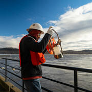
The Virginia Extensometer Network
Borehole extensometers are instruments that monitor land subsidence caused by aquifer compaction. They provide precise, high-resolution measurements of changes in aquifer-system thickness. These changes in aquifer-system thickness contribute to vertical land motion (VLM) across the Virginia Coastal Plain, and are driven primarily by groundwater level decline due to human water usage. The Virginia...

Progress Through Partnerships - Chesapeake Bay Vertical Land Motion Project
Chesapeake Bay region has the highest rate of relative sea-level rise on the Atlantic Coast of the United States, and data indicate that vertical land motion in the form of subsidence has been responsible for more than half the relative sea-level rise measured in the Chesapeake Bay region. The Chesapeake Bay Vertical Land Motion Project is a cooperative effort between the USGS and our many...

A Science-Based Approach for Targeting Resources to Achieve Multiple Chesapeake Outcomes
Issue: The Chesapeake Bay Program (CBP) needs to accelerate progress on multiple outcomes to meet deadlines in the Chesapeake Watershed Agreement. The CBP partnership spends about $1.2B annually on activities toward achieving the Watershed Agreement, with a focus on water-quality improvement. Recent funding increases, including the Bipartisan Infrastructure Law, provide additional opportunities to...

USGS Part of New Federal Effort to Address Climate Change in the Chesapeake Watershed
Issue: The federal government will work together to implement the Chesapeake Executive Council Directive No. 21-1 Collective Action for Climate Change, recognizing that urgent attention is needed to confront the challenges that a changing climate poses to the Chesapeake Bay region. The Directive emphasizes the importance of the “…resiliency of the Chesapeake Bay Watershed, including its living...