
Essential gear for measuring streamflow above large rivers. Within this cable car a reel connects to a Price AA flowmeter and sounding weight. Hydrologic technicians reel down the weight until they hit the river bottom, input the total depth into the AquaCalc, then they measure the flow within the water column at various depths to best capture water velocities.
Images
Check out photos of some of the awesome work USGS scientists and field technicians have done over the years.
Filter Total Items: 377

AA meter set up in cable car
Essential gear for measuring streamflow above large rivers. Within this cable car a reel connects to a Price AA flowmeter and sounding weight. Hydrologic technicians reel down the weight until they hit the river bottom, input the total depth into the AquaCalc, then they measure the flow within the water column at various depths to best capture water velocities.

Sediment sampler at Breitenbush River
Sediment samplers are designed to obtain representative samples across all depths and locations in a river cross-section. This is important because sediment concentrations are not always consistent across the channel. This D-74 sampler weighs 62 pounds and can sample in velocities up to 6.6 feet per second and depths up to 15 feet. It has been in use since 1974.
Sediment samplers are designed to obtain representative samples across all depths and locations in a river cross-section. This is important because sediment concentrations are not always consistent across the channel. This D-74 sampler weighs 62 pounds and can sample in velocities up to 6.6 feet per second and depths up to 15 feet. It has been in use since 1974.

Fall Creek meets the Middle Willamette River flows
Fall Creek meets the Middle Willamette River flowsA striking contrast between the clear water in the Middle Fork Willamette River and brown water in Fall Creek. The flows from Fall Creek dam during this time had heavy loads of suspended sediment from the reservoir drawdown.

South Santiam River near Foster, Oregon
Photo taken during the Green Peter Reservoir drawdown The water is brown due to suspended sediment loads.
Photo taken during the Green Peter Reservoir drawdown The water is brown due to suspended sediment loads.


Substrate mapping on Little North Santiam
River bed-sediment size and distribution is critical for fish spawning habitat. The kayaking scientist in this photo is towing an advanced acoustic instrument that measures river velocity and depth. In addition, a camera captures photos that can be used to create digital elevation models and eventually maps of river bed-sediment size.
River bed-sediment size and distribution is critical for fish spawning habitat. The kayaking scientist in this photo is towing an advanced acoustic instrument that measures river velocity and depth. In addition, a camera captures photos that can be used to create digital elevation models and eventually maps of river bed-sediment size.

Survey on the North Santiam River
Researcher collecting depth, velocity, water surface elevation, and 360 degree imagery on the North Santiam River.
Researcher collecting depth, velocity, water surface elevation, and 360 degree imagery on the North Santiam River.

Field work on the North Santiam
Researchers prep equipment before a river mapping survey on the Niagara section of the North Santiam River.
Researchers prep equipment before a river mapping survey on the Niagara section of the North Santiam River.
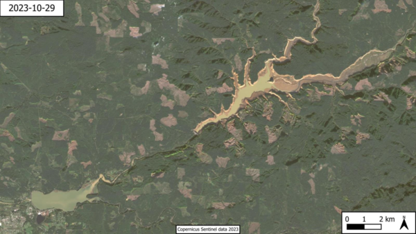
Foster and Green Peter Lakes, Copernicus Sentinel data 2023
Foster and Green Peter Lakes, Copernicus Sentinel data 2023European Space Agency Sentinel-2 satellite image of Foster and Green Peter Lakes showing turbidity conditions during the 2023 drawdown.
Foster and Green Peter Lakes, Copernicus Sentinel data 2023
Foster and Green Peter Lakes, Copernicus Sentinel data 2023European Space Agency Sentinel-2 satellite image of Foster and Green Peter Lakes showing turbidity conditions during the 2023 drawdown.


Bulrush growing in Malheur Lake
Following a wet winter, bulrush is shown growing in Malheur Lake. Emergent vegetation like bulrush provides nesting habitat and food resources for birds.
Following a wet winter, bulrush is shown growing in Malheur Lake. Emergent vegetation like bulrush provides nesting habitat and food resources for birds.

Landscape of the Columbia River Plateau
Black angular basalt fragments in the foreground against a backdrop of rolling yellow hills.
Black angular basalt fragments in the foreground against a backdrop of rolling yellow hills.

Columbia River at The Dalles monitoring station
The small house is the monitoring station for Columbia River at The Dalles. The house protects sensitive electronics from the elements.
The small house is the monitoring station for Columbia River at The Dalles. The house protects sensitive electronics from the elements.

Substrate Mapping on the Little North Santiam River
Substrate Mapping on the Little North Santiam RiverA substrate mapping survey in action. Scientists aim to map the size and distribution of river sediments.
Substrate Mapping on the Little North Santiam River
Substrate Mapping on the Little North Santiam RiverA substrate mapping survey in action. Scientists aim to map the size and distribution of river sediments.

Chinook Salmon
Native fish populations, like the Chinook salmon during spawning season, rely on the Santiam River.
Native fish populations, like the Chinook salmon during spawning season, rely on the Santiam River.

Water quality sensor inspection - Willamette River
Water quality sensor inspection - Willamette RiverHydrologic technician, Ann McGowan, shows OMSI representative a water quality sensor deployed in the Willamette River near OMSI. This sensor monitors water temperature, dissolved oxygen, chlorophyll, blue green algea, specific conductance and pH. The sensors need cleaned every 4-6 weeks.

Water Sampling on the Willamette River
Hydrologist Kurt Carpenter demonstrated gathering a water sample from the Willamette on the docks at OMSI. The netting gets pulled through the water and is then funneled into a sample bottle.
Hydrologist Kurt Carpenter demonstrated gathering a water sample from the Willamette on the docks at OMSI. The netting gets pulled through the water and is then funneled into a sample bottle.

Oregon Water Science Center staff accept centennial monitoring station award
Oregon Water Science Center staff accept centennial monitoring station awardOregon Water Science Center received the award plaques during the 2023 USGS National Data Training Conference in Phoenix Arizona. Pictured right to left: Marc Stewart, Deputy Director for Data, followed by expert hydrologic technicians; Carrie Boudreau, Amarys Acosta, Scott Deweese, and Tasha Albertson-Herberholz.

Harmful Algae Bloom seen near USGS gage on OMSI docks
Harmful Algae Bloom seen near USGS gage on OMSI docksGreen cyanobacteria in the Willamette River at the new USGS water quality monitor at OMSI.
Harmful Algae Bloom seen near USGS gage on OMSI docks
Harmful Algae Bloom seen near USGS gage on OMSI docksGreen cyanobacteria in the Willamette River at the new USGS water quality monitor at OMSI.

Streaks of blue-green cyanobacteria in the Willamette River
Streaks of blue-green cyanobacteria in the Willamette RiverStreaks of blue-green cyanobacteria in the Willamette River at the new USGS water-quality monitor at OMSI.
Streaks of blue-green cyanobacteria in the Willamette River
Streaks of blue-green cyanobacteria in the Willamette RiverStreaks of blue-green cyanobacteria in the Willamette River at the new USGS water-quality monitor at OMSI.

Cyanobacteria in the Willamette River
Cyanobacteria in the Willamette River near new USGS water quality monitor at OMSI. Photo courtesy of Kale Clausen (ODEQ).
Cyanobacteria in the Willamette River near new USGS water quality monitor at OMSI. Photo courtesy of Kale Clausen (ODEQ).