
Fragilaria crotonensis is a well-known species of planktonic diatom within the genus Fragilaria, commonly found in freshwater lakes across North America and other temperate regions.
Images
Check out photos of some of the awesome work USGS scientists and field technicians have done over the years.
Filter Total Items: 377

Fragilaria crotonensis - planktonic diatom
Fragilaria crotonensis is a well-known species of planktonic diatom within the genus Fragilaria, commonly found in freshwater lakes across North America and other temperate regions.

Technicians at the Willamette River below Holgate Channel water-quality monitor station
Technicians at the Willamette River below Holgate Channel water-quality monitor stationTwo technicians deployed the water-quality monitor for the 2025 season on the dock at OMSI. See the data live: Willamette River Below the Holgate Channel, Portland, OR
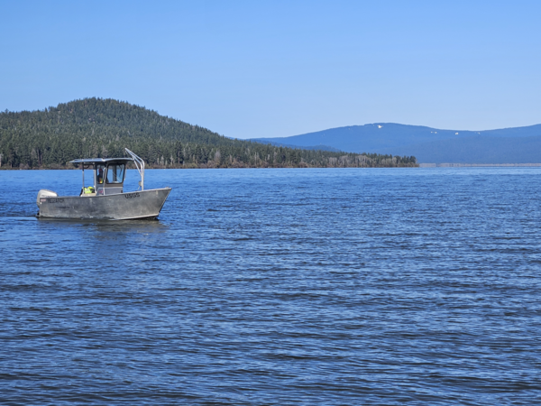
Upper Klamath Lake - Shoalwater Bay
A USGS research boat cruises through Shoalwater Bay on the west side of Upper Klamath Lake, Oregon.
A USGS research boat cruises through Shoalwater Bay on the west side of Upper Klamath Lake, Oregon.

Chicken Creek sediment sampling
USGS staff member collects sediment samples at the upstream Chicken Creek water-quality monitoring location in the Tualatin River National Wildlife Refuge.
USGS staff member collects sediment samples at the upstream Chicken Creek water-quality monitoring location in the Tualatin River National Wildlife Refuge.

Data Collection at Chicken Creek
USGS hydrologist, Erin Leahy, collecting data in Chicken Creek in the Tualatin River National Wildlife Refuge. The USGS operates two water-quality monitors along Chicken Creek.
USGS hydrologist, Erin Leahy, collecting data in Chicken Creek in the Tualatin River National Wildlife Refuge. The USGS operates two water-quality monitors along Chicken Creek.

Chicken Creek sediment sampling
USGS hydrologic technician, Heather Bragg, uses a 2-wheel crane to lower a sediment sampler into Chicken Creek below.
USGS hydrologic technician, Heather Bragg, uses a 2-wheel crane to lower a sediment sampler into Chicken Creek below.

Chicken Creek downstream near the Tualatin River
Chicken Creek in the Tualatin River National Wildlife Refuge. The Refuge has over 200 species of birds and a variety of other wildlife.
Chicken Creek in the Tualatin River National Wildlife Refuge. The Refuge has over 200 species of birds and a variety of other wildlife.

Chicken Creek sediment sampling
USGS hydrologist, Erin Leahy, collects sediment samples at the upstream gage on Chicken Creek in the Tualatin River National Wildlife Refuge.
USGS hydrologist, Erin Leahy, collects sediment samples at the upstream gage on Chicken Creek in the Tualatin River National Wildlife Refuge.

Williamson River near Klamath Agency, OR
In March 2025 the streamgage on the Williamson River Near Klamath Agency, Oregon (11493500) recorded significant flow for the first time since March 2020. The aluminum cylinder on the right houses the gage equipment.
In March 2025 the streamgage on the Williamson River Near Klamath Agency, Oregon (11493500) recorded significant flow for the first time since March 2020. The aluminum cylinder on the right houses the gage equipment.
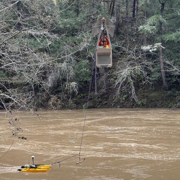
High-flow measurement at Cow Creek near Riddle, OR
High-flow measurement at Cow Creek near Riddle, ORCow Creek near Riddle, Oregon (1431000): On March 17, 2025, hydrologic technicians captured 14,000 and 13,900 cubic feet per second! These are the 2nd and 3rd highest flow measurements since the period of record began in 1954.
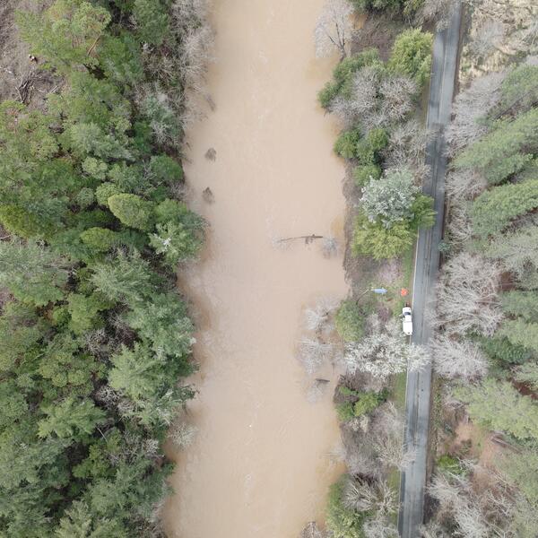
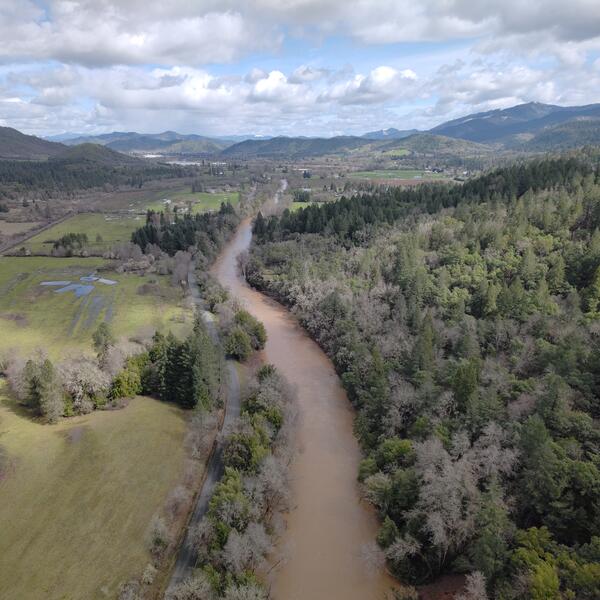
Drone-based surface velocimetry at Cow Creek near Riddle
Drone-based surface velocimetry at Cow Creek near RiddleThis aerial image was captured during a drone flight for drone-based surface velocimetry, which is a method for measuring the speed of water at the surface of a river or stream using video footage and computer software.
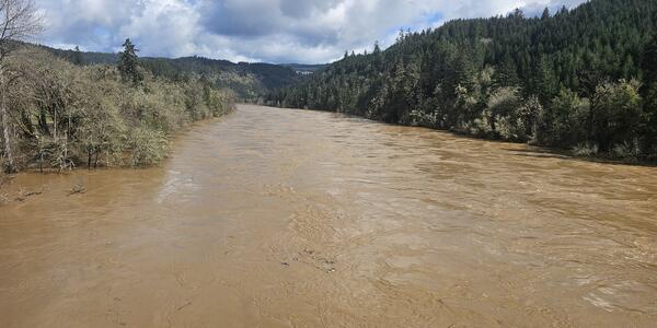
Spring high-flow on the Umpqua River
A USGS hydrologic technician captured this photo of the Umpqua River near Elkton, Oregon, during a high-flow measurement—the third-highest flow recorded at this gage since it began operation in 1905. View gage data.
A USGS hydrologic technician captured this photo of the Umpqua River near Elkton, Oregon, during a high-flow measurement—the third-highest flow recorded at this gage since it began operation in 1905. View gage data.

High-flow conditions on the Umpqua River near Elkton
High-flow conditions on the Umpqua River near ElktonHydrologic technicians captured the powerful high flow of the Umpqua River near Elkton, measuring an impressive 128,000 cubic feet per second on March 17th, 2025. This marks the third-highest flow measured since monitoring began in 1905.
Drone shot of Cow Creek near Riddle, OR
This aerial image was captured during a drone flight for drone-based surface velocimetry, which is a method for measuring the speed of water at the surface of a river or stream using video footage and computer software.
This aerial image was captured during a drone flight for drone-based surface velocimetry, which is a method for measuring the speed of water at the surface of a river or stream using video footage and computer software.

Cleaning a water-quality sonde
During a routine cleaning, a technician holds up a water-quality sonde to show its sensors. Each sensor measures a different water-quality value, such as temperature or dissolved oxygen. A central wiper helps keep the sensors clean between technician inspections.
During a routine cleaning, a technician holds up a water-quality sonde to show its sensors. Each sensor measures a different water-quality value, such as temperature or dissolved oxygen. A central wiper helps keep the sensors clean between technician inspections.

Sonar install at Youngs Bay Bridge
The sonar equipment monitors streambed elevation near the bridge footing to measure scour depth. Accurately measuring scour depth is essential for evaluating bridge safety. During short storm events, crews may not arrive in time to monitor in real-time. Without continuous monitoring, the deepest scour could be missed if the hole refills before inspection.
The sonar equipment monitors streambed elevation near the bridge footing to measure scour depth. Accurately measuring scour depth is essential for evaluating bridge safety. During short storm events, crews may not arrive in time to monitor in real-time. Without continuous monitoring, the deepest scour could be missed if the hole refills before inspection.

Installing sonar equipment at Luckiamute River
Field crew installs sonar equipment on the highway 99W bridge over the Luckiamute River near Parker Oregon.
Field crew installs sonar equipment on the highway 99W bridge over the Luckiamute River near Parker Oregon.

Tualatin River in the fall
The Tualatin River in Oregon flows approximately 83 miles from the Northern Oregon Coast Range to the Willamette River, providing vital water resources and habitat across the Tualatin Valley.
The Tualatin River in Oregon flows approximately 83 miles from the Northern Oregon Coast Range to the Willamette River, providing vital water resources and habitat across the Tualatin Valley.

Long Tom River
When Fern Ridge Lake levels are low the Long Tom River can be seen meandering through the reservoir. Check out the USGS water elevation gage at Fern Ridge Lake Near Elmira, OR - 14168000.
When Fern Ridge Lake levels are low the Long Tom River can be seen meandering through the reservoir. Check out the USGS water elevation gage at Fern Ridge Lake Near Elmira, OR - 14168000.

Fern Ridge Reservoir during low water level
USGS Hydrologist is looking at a headcut/headward erosion/knickpoint in thr center-right of photo during field effort to verify geomorphic mapping.
USGS Hydrologist is looking at a headcut/headward erosion/knickpoint in thr center-right of photo during field effort to verify geomorphic mapping.

Hydrologic technician at the South Santiam streamflow gage
Hydrologic technician at the South Santiam streamflow gageMorgan, an Oregon Water Science Center hydrologic technician stands under a rainbow during field work at the South Santiam River near Foster, OR streamflow gage (14187200).
Hydrologic technician at the South Santiam streamflow gage
Hydrologic technician at the South Santiam streamflow gageMorgan, an Oregon Water Science Center hydrologic technician stands under a rainbow during field work at the South Santiam River near Foster, OR streamflow gage (14187200).