
A USGS hydrologic technician measures the height of the water to verify the lake sensors are reading correctly.
Images
Check out photos of some of the awesome work USGS scientists and field technicians have done over the years.
Filter Total Items: 377
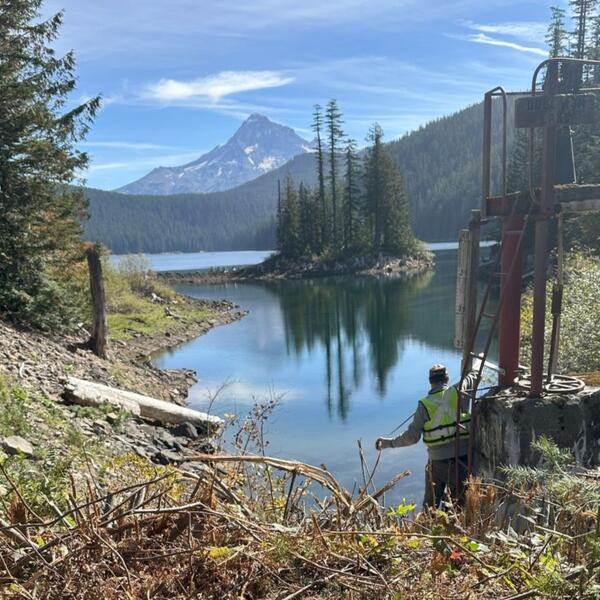
Bull Run Lake
A USGS hydrologic technician measures the height of the water to verify the lake sensors are reading correctly.
Tualatin River at Oswego Dam
Downstream view of the Tualatin River at the Oswego dam water-quality monitoring station during a routine site inspection.
Downstream view of the Tualatin River at the Oswego dam water-quality monitoring station during a routine site inspection.

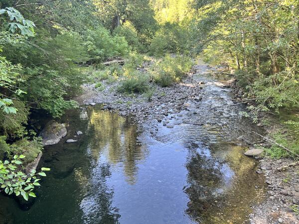
Quartzville Creek below Galena Creek near Cascadia (14185865)
Quartzville Creek below Galena Creek near Cascadia (14185865)Quartzville Creek below Galena Creek near Cascadia (14185865). The U.S. Geological Survey monitors monitors water level, water temperature and air temperature at this location.
Quartzville Creek below Galena Creek near Cascadia (14185865)
Quartzville Creek below Galena Creek near Cascadia (14185865)Quartzville Creek below Galena Creek near Cascadia (14185865). The U.S. Geological Survey monitors monitors water level, water temperature and air temperature at this location.
Molalla River above Pine Creek near Wilhoit (14198500)
Molalla River above Pine Creek near Wilhoit (14198500)Molalla River above Pine Creek near Wilhoit (14198500). The U.S. Geological Survey monitors water level, water temperature and air temperature at this location.
Molalla River above Pine Creek near Wilhoit (14198500)
Molalla River above Pine Creek near Wilhoit (14198500)Molalla River above Pine Creek near Wilhoit (14198500). The U.S. Geological Survey monitors water level, water temperature and air temperature at this location.

Cyanobacteria Willamette River
Streaks of cyanobacteria near the surface of the Willamette River inside the Ross Island Lagoon.
Streaks of cyanobacteria near the surface of the Willamette River inside the Ross Island Lagoon.

Oregon stream gage web traffic 2024
Weekly web visits to USGS Oregon stream monitoring stations from September 25, 2023 to July 15, 2024. A bar graph on the bottom flashes an orange bar for each week. The height of each bar represents the amount of internet users that visited the page that week.
Weekly web visits to USGS Oregon stream monitoring stations from September 25, 2023 to July 15, 2024. A bar graph on the bottom flashes an orange bar for each week. The height of each bar represents the amount of internet users that visited the page that week.

S.F. McKenzie River
Photo taken after measuring the streamflow volume on the South Fork McKenzie River, above Cougar Reservoir.
Photo taken after measuring the streamflow volume on the South Fork McKenzie River, above Cougar Reservoir.

Horse Creek, Oregon
Horse Creek is a tributary of the McKenzie River, situated near the unincorporated community of McKenzie Bridge in Lane County, Oregon, USA.
Horse Creek is a tributary of the McKenzie River, situated near the unincorporated community of McKenzie Bridge in Lane County, Oregon, USA.

View of nose of Bell Jet Helicopter with a thermal infrared and true-color sensor co-mounted to the underside
View of nose of Bell Jet Helicopter with a thermal infrared and true-color sensor co-mounted to the undersideProfile view of a Bell Jet Helicopter with a thermal infrared and true-color sensor co-mounted to the underside of the nose. These sensors are used in airborne thermal infrared surveys for remotely sensing land/water surface temperature.

Fall Creek above Tiller Creek near Lowell (14150250)
Fall Creek above Tiller Creek near Lowell (14150250)Fall Creek above Tiller Creek near Lowell (14150250). The U.S. Geological Survey monitors monitors water level, water temperature and air temperature at this location.
Fall Creek above Tiller Creek near Lowell (14150250)
Fall Creek above Tiller Creek near Lowell (14150250)Fall Creek above Tiller Creek near Lowell (14150250). The U.S. Geological Survey monitors monitors water level, water temperature and air temperature at this location.
Clackamas River at Big Bottom (14208000)
Clackamas River at Big Bottom (14208000). The U.S. Geological Survey monitors water level, water temperature, and air temperature at this location.
Clackamas River at Big Bottom (14208000). The U.S. Geological Survey monitors water level, water temperature, and air temperature at this location.
Middle Santiam River near Santiam Junction (14185600)
Middle Santiam River near Santiam Junction (14185600)Middle Santiam River near Santiam Junction (14185600). The U.S. Geological Survey monitors monitors water level, water temperature and air temperature at this location.
Middle Santiam River near Santiam Junction (14185600)
Middle Santiam River near Santiam Junction (14185600)Middle Santiam River near Santiam Junction (14185600). The U.S. Geological Survey monitors monitors water level, water temperature and air temperature at this location.

The Klamath Marsh
Looking southwest from Silver Lake Rd. towards Wocus Bay in the Klamath Marsh. The upper reaches of the Williamson River winds through the marshland.
Looking southwest from Silver Lake Rd. towards Wocus Bay in the Klamath Marsh. The upper reaches of the Williamson River winds through the marshland.

Williamson River in the Klamath Marsh
Looking northwest from Military Crossing Rd with the Williamson River in the foreground.
Looking northwest from Military Crossing Rd with the Williamson River in the foreground.

Klamath Marsh, Oregon
Looking southwest from Military Crossing Road with Mt. Scott in the background. The Williamson River makes its way through dense marsh vegetation.
Looking southwest from Military Crossing Road with Mt. Scott in the background. The Williamson River makes its way through dense marsh vegetation.
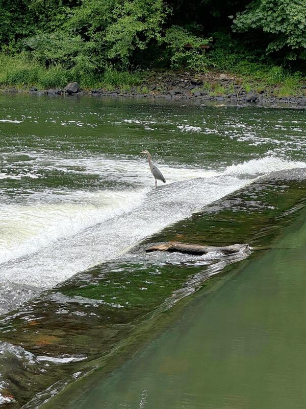
Blue Heron on the Tualatin River
A USGS field technician enjoyed a sighting of a Blue Heron while inspecting water-quality gage equipment on the Tualatin River at the Oswego Dam site (14207200).
A USGS field technician enjoyed a sighting of a Blue Heron while inspecting water-quality gage equipment on the Tualatin River at the Oswego Dam site (14207200).
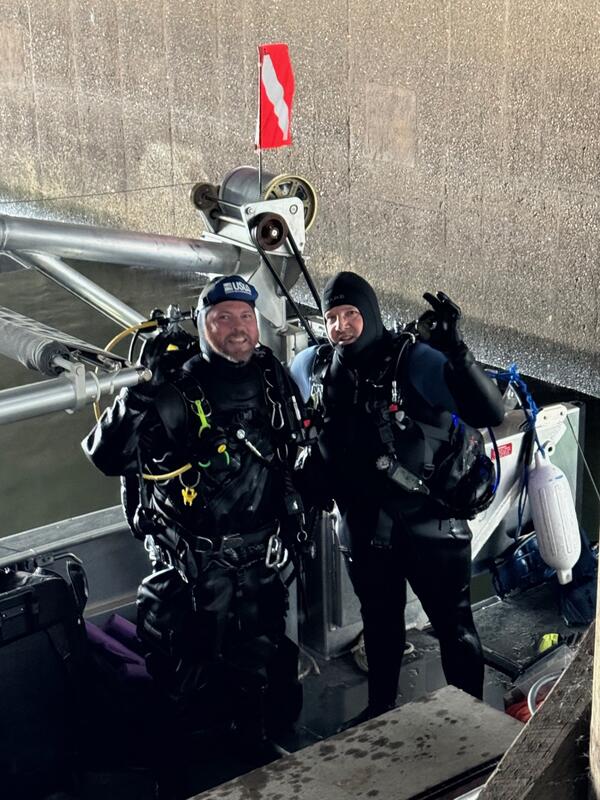
USGS dive team
Sometimes equipment can only be accessed by diving to it!
Sometimes equipment can only be accessed by diving to it!
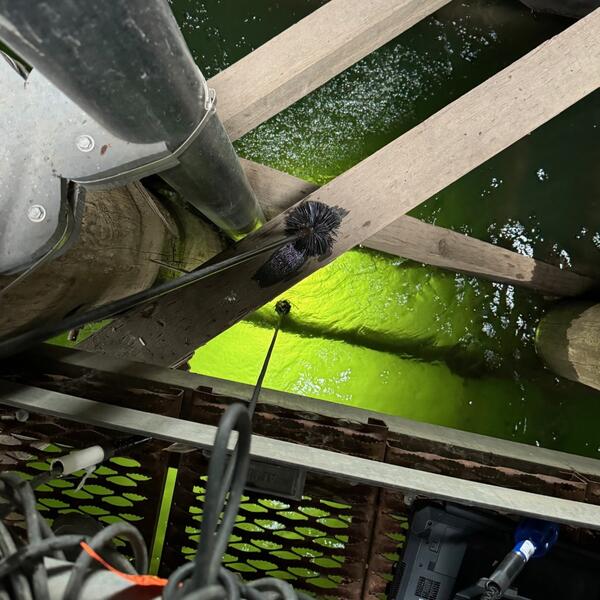
Willamette River water-quality inspection
View from a metal platform looking down into the Willamette River. Technicians use a freshly calibrated "reference monitor" to verify site monitor readings. Here, a reference monitor hangs from the platform into the water.
View from a metal platform looking down into the Willamette River. Technicians use a freshly calibrated "reference monitor" to verify site monitor readings. Here, a reference monitor hangs from the platform into the water.

Groundwater irrigation well
A groundwater irrigation well supplies water to a small channel in southern Oregon.
A groundwater irrigation well supplies water to a small channel in southern Oregon.

Shore of Lake Abert, Oregon
Lake Abert, Oregon is one of the 20 terminal lakes identified by USGS partners as priority ecosystems for study by the Saline Lakes Ecosystems IWAA.
By
Ecosystems Mission Area, Water Resources Mission Area, Forest and Rangeland Ecosystem Science Center, Fort Collins Science Center, Nevada Water Science Center, Oregon Water Science Center, Utah Water Science Center, Western Ecological Research Center (WERC), Saline Lake Ecosystems Integrated Water Availability Assessment
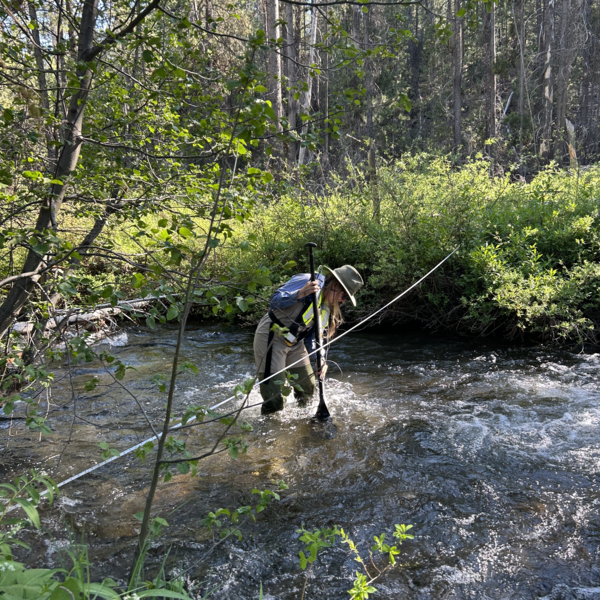
Temperature cross-section measurements at Miller Creek
Temperature cross-section measurements at Miller CreekFormer Hydrologic Technician, Paige Preston, collects temperature readings in Miller Creek (11491950) near Beaver Marsh, Oregon. The paddle helps to hold the sensor in place.
Temperature cross-section measurements at Miller Creek
Temperature cross-section measurements at Miller CreekFormer Hydrologic Technician, Paige Preston, collects temperature readings in Miller Creek (11491950) near Beaver Marsh, Oregon. The paddle helps to hold the sensor in place.