
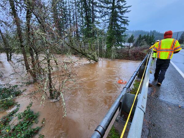
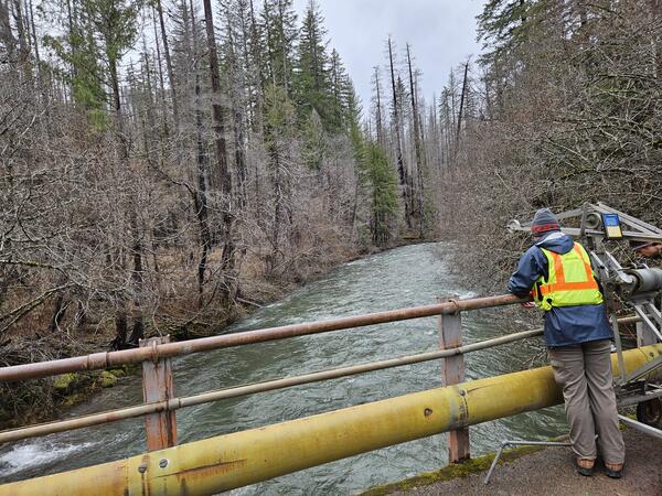
Oregon Water Science Center Hydrologic Technicians, Ben Thorpe, Kyle Flannery, and Itziar Zandueta Lopez, measured high flows on the Mohawk River Near Springfield, OR (14165000), concurrently using an Acoustic Dopple
Images
Check out photos of some of the awesome work USGS scientists and field technicians have done over the years.
Filter Total Items: 377
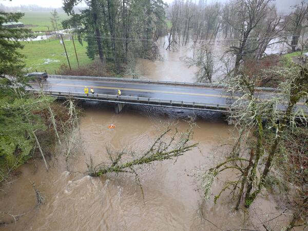
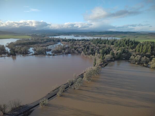
Aerial view of the Mohawk River
Oregon Water Science Center Hydrologic Technicians, Ben Thorpe, Kyle Flannery, and Itziar Zandueta Lopez, measured high flows on the Mohawk River Near Springfield, OR (14165000), concurrently using an Acoustic Dopple
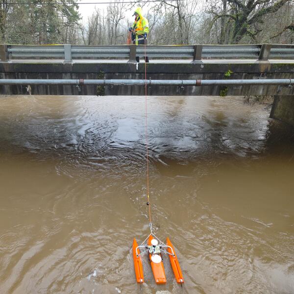
Mohawk River high-flow measurement
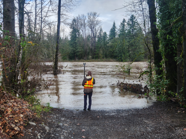
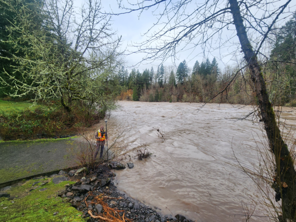
Oregon Water Science Center Eugene Field Office Hydrologic Technician Itziar Zandueta Lopez, measuring high-flows at Mohawk River Near Springfield, OR (14165000) concurrently using an Acoustic Doppler Current Profile
Oregon Water Science Center Eugene Field Office Hydrologic Technician Itziar Zandueta Lopez, measuring high-flows at Mohawk River Near Springfield, OR (14165000) concurrently using an Acoustic Doppler Current Profile
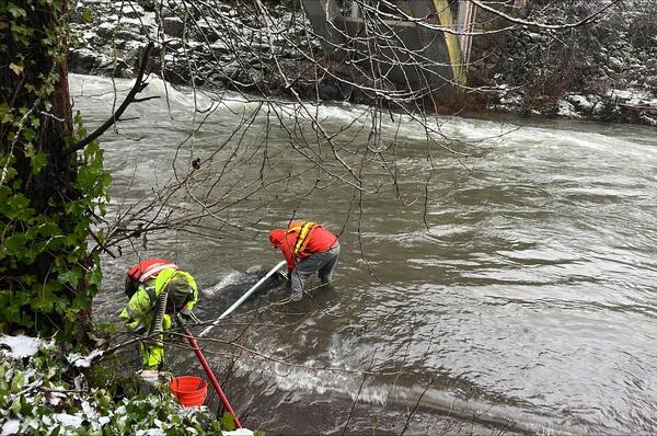
Chicken Creek high-flow measurement
Hydrologic technicians Adam and Vanessa make a flow measurement using an acoustic doppler current profiler (ADCP). The ADCP is tethered to a rope and is pulled across the channel so it can collect channel depth and flow velocity measurements. The technicians did a great job getting a measurement close to the peak flow at this site on December 19, 2025.
Hydrologic technicians Adam and Vanessa make a flow measurement using an acoustic doppler current profiler (ADCP). The ADCP is tethered to a rope and is pulled across the channel so it can collect channel depth and flow velocity measurements. The technicians did a great job getting a measurement close to the peak flow at this site on December 19, 2025.
Mohawk River high-flow measurement
Oregon Water Science Center Eugene Field Office Hydrologic Technicians, Ben Thorpe, Kyle Flannery, and Itziar Zandueta Lopez, measured high-flows at Mohawk River Near Springfield, OR - USGS-14165000 concurrently usin
Oregon Water Science Center Eugene Field Office Hydrologic Technicians, Ben Thorpe, Kyle Flannery, and Itziar Zandueta Lopez, measured high-flows at Mohawk River Near Springfield, OR - USGS-14165000 concurrently usin
Clackamas River high-flow survey
USGS scientist, wearing a personal protection device, or PFD, surveys water levels and debris line on the Clackamas River, Milo McIver park boat ramp. These measurements are used to validate a 2D hydraulic model of the Clackamas River.
USGS scientist, wearing a personal protection device, or PFD, surveys water levels and debris line on the Clackamas River, Milo McIver park boat ramp. These measurements are used to validate a 2D hydraulic model of the Clackamas River.
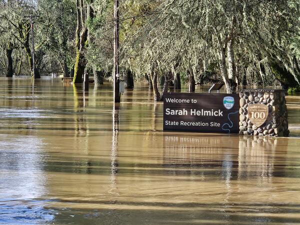
Flooded Sarah Helmick State Recreation Site along the Luckiamute River
Flooded Sarah Helmick State Recreation Site along the Luckiamute RiverField technicians braved the flooded park to collect critical streamflow measurements nearby. The Luckiamute River Near Suver, OR (# 14190500) is operated in cooperation with the US Army Corps of Engineers and is a USGS Federal Priority Streamgage.
Clackamas River floods Barton Park
In December 2025 USGS field crews captured photos of Clackamas River flooding at Barton Park while surveying the scale of the flood.
In December 2025 USGS field crews captured photos of Clackamas River flooding at Barton Park while surveying the scale of the flood.
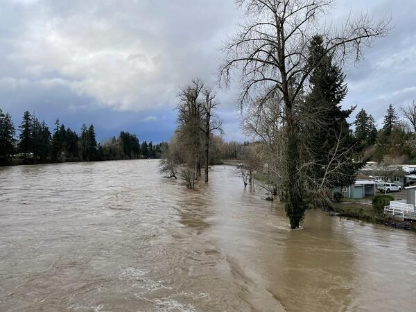
Flood waters on the Clackamas River
High-flows on the Clackamas River seen from the Carver Bridge, in Carver Oregon.
High-flows on the Clackamas River seen from the Carver Bridge, in Carver Oregon.
Nearly flooded Buena Vista Road near Luckiamute River
Nearly flooded Buena Vista Road near Luckiamute RiverUSGS Hydrologic Technicians captured this aerial image with a drone during field. The USGS Oregon Water Science Center operates a streamflow gaging station nearby on the Luckiamute River.
Nearly flooded Buena Vista Road near Luckiamute River
Nearly flooded Buena Vista Road near Luckiamute RiverUSGS Hydrologic Technicians captured this aerial image with a drone during field. The USGS Oregon Water Science Center operates a streamflow gaging station nearby on the Luckiamute River.
Hood River at Tucker Bridge: high flow repairs
Hydrologic technicians installing temporary orifice line in the stream to restore stage readings during a rising flood.
Hydrologic technicians installing temporary orifice line in the stream to restore stage readings during a rising flood.
Hood River at Tucker Bridge, near Hood River Oregon
Hood River at Tucker Bridge, near Hood River OregonRising waters near the USGS streamflow gage along Hood River.
Hood River at Tucker Bridge, near Hood River Oregon
Hood River at Tucker Bridge, near Hood River OregonRising waters near the USGS streamflow gage along Hood River.
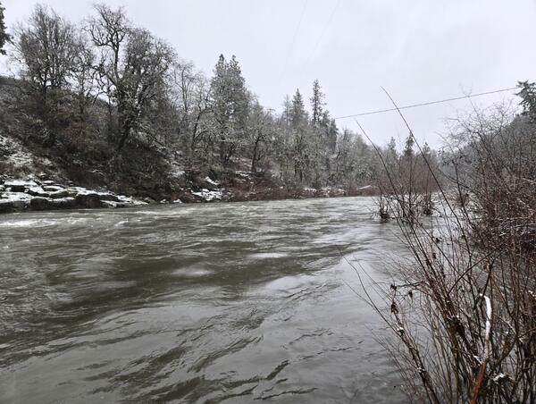
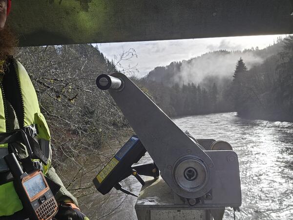
Nahelem River near Foss, Oregon - High flow
A highly skilled hydrologic technician measures high flows from a cable way over the Nehalem River near Foss, OR.
A highly skilled hydrologic technician measures high flows from a cable way over the Nehalem River near Foss, OR.
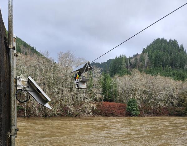
Nahelem River near Foss, Oregon - High flow
A skilled hydrologic technician measures high flows from a cable car over the Nehalem River near Foss, OR.
A skilled hydrologic technician measures high flows from a cable car over the Nehalem River near Foss, OR.
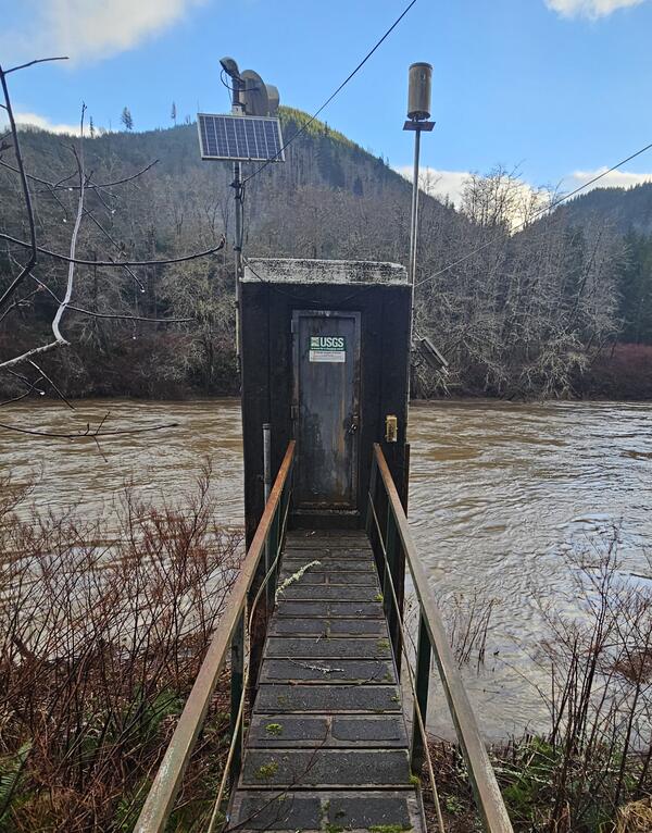
Nehalem River near Foss, gage house
The concrete gage house on the Nehalem River near Foss, OR. This site (# 14301000) is a USGS Federal Priority streamgage.
The concrete gage house on the Nehalem River near Foss, OR. This site (# 14301000) is a USGS Federal Priority streamgage.
Breitenbush River Blw Breitenbush Hot Springs, OR - High Flows
Breitenbush River Blw Breitenbush Hot Springs, OR - High FlowsA hydrologic technician measures the Breitenbush River below Breitenbush Hot Springs, OR, (# 14178610).
Breitenbush River Blw Breitenbush Hot Springs, OR - High Flows
Breitenbush River Blw Breitenbush Hot Springs, OR - High FlowsA hydrologic technician measures the Breitenbush River below Breitenbush Hot Springs, OR, (# 14178610).
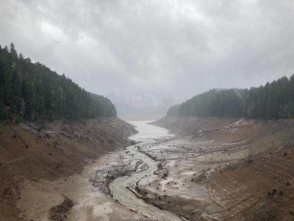
Green Peter Reservoir drawdown 2025
Green Peter Reservoir drawn down to a free-flowing stream channel winding through muddy sediment.
Green Peter Reservoir drawn down to a free-flowing stream channel winding through muddy sediment.
Deschutes River near Culver, Oregon - High flow
This high flow measurement on the Deschutes River near Culver, OR was the highest measurement since 2017. This site (# 14076500) is operated in cooperation with Portland General Electric.
This high flow measurement on the Deschutes River near Culver, OR was the highest measurement since 2017. This site (# 14076500) is operated in cooperation with Portland General Electric.
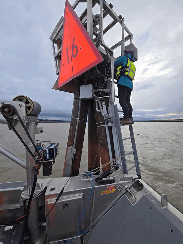
Columbia River at Vancouver
A highly skilled hydrologic technician maintains monitoring equipment in the Columbia River at Vancouver, WA. They are climbing a structure called a "dolphin". In maritime terms, a dolphin is a cluster of pilings driven into the riverbed, often used for mooring or as a base for a light or sign. This dolphin also secures USGS equipment critical for flow monitoring.
A highly skilled hydrologic technician maintains monitoring equipment in the Columbia River at Vancouver, WA. They are climbing a structure called a "dolphin". In maritime terms, a dolphin is a cluster of pilings driven into the riverbed, often used for mooring or as a base for a light or sign. This dolphin also secures USGS equipment critical for flow monitoring.
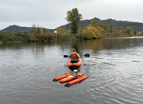
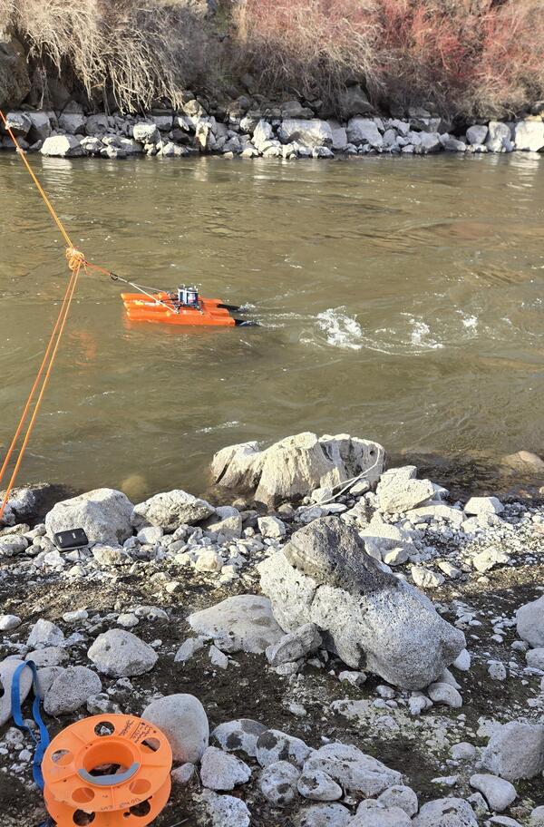
South Umpqua River at Melrose, Oregon - flow measurement
South Umpqua River at Melrose, Oregon - flow measurementA highly skilled hydrologic technician takes a flow measurement by kayaking an Acoustic Doppler Current Profilier (ADCP) across the channel. The ADCP uses sound waves to measure water speed and depth, to calculate flow volumes.