
Global Marine Mineral Resources Group. From left to right, USGS Research Oceanographer Amy Gartman, visiting scientist Mariana Benites from University São Paolo, USGS Physical Scientist Denise Payan, graduate student Noemi Ortega Dominguez, student contractor Manda Au, and USGS Research Oceanographer Kira Mizell.
Images
Pacific Coastal and Marine Science Center images.
Filter Total Items: 1387

Global Marine Mineral Resources Group
Global Marine Mineral Resources Group. From left to right, USGS Research Oceanographer Amy Gartman, visiting scientist Mariana Benites from University São Paolo, USGS Physical Scientist Denise Payan, graduate student Noemi Ortega Dominguez, student contractor Manda Au, and USGS Research Oceanographer Kira Mizell.

Fire plus Flood equals Beach
Triptych of images showing wildfire, roadside flooding, and the Big Sur coastline in California.
Triptych of images showing wildfire, roadside flooding, and the Big Sur coastline in California.

The wee strand, Loch Indaal, Scotland
The wee strand is a beach along the head of of Loch Indaal, Scotland. Loch Indaal is an ocean bay on Islay, the southernmost island of the Hebrides, off the west coast of Scotland.
The wee strand is a beach along the head of of Loch Indaal, Scotland. Loch Indaal is an ocean bay on Islay, the southernmost island of the Hebrides, off the west coast of Scotland.

Jumbo Piston Corer
Upgraded USGS jumbo piston corer being readied for deployment off the research vessel Hugh R. Sharp in April 2022.
Upgraded USGS jumbo piston corer being readied for deployment off the research vessel Hugh R. Sharp in April 2022.

USGS ocean current drifter disk
None the worse for wear, a plastic, ocean current drifter disk, originally released off Barter Island in Alaska, was discovered on the coast of Scotland 37 years after its initial release into the ocean.
None the worse for wear, a plastic, ocean current drifter disk, originally released off Barter Island in Alaska, was discovered on the coast of Scotland 37 years after its initial release into the ocean.

USGS ocean drifter
A 37-year-old plastic ocean drifter, originally released off Barter Island in Alaska, was discovered on the coast of Scotland.
A 37-year-old plastic ocean drifter, originally released off Barter Island in Alaska, was discovered on the coast of Scotland.

PCMSC scientist measuring land-surface elevation near the bay-marsh edge of Whale's Tail South marsh
PCMSC scientist measuring land-surface elevation near the bay-marsh edge of Whale's Tail South marshPCMSC scientist measuring land-surface elevation near the bay-marsh edge of Whale's Tail South marsh in Eden Landing Ecological Reserve, Hayward, CA, with birds foraging on the South San Francisco Bay mudflats at low tide in the background.
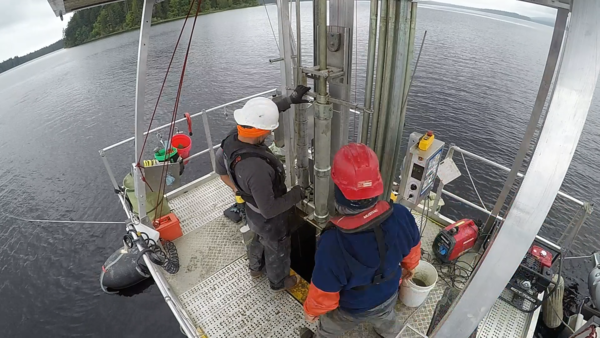
Scientists at Ozette Lake operating the Uwitech coring platform in 2021
Scientists at Ozette Lake operating the Uwitech coring platform in 2021Scientists at Ozette Lake operating the Uwitech coring platform in 2021.
Scientists at Ozette Lake operating the Uwitech coring platform in 2021
Scientists at Ozette Lake operating the Uwitech coring platform in 2021Scientists at Ozette Lake operating the Uwitech coring platform in 2021.

Scientists from PCMSC deploying instruments to measure water level and suspended-sediment concentration in Whale's Tail South marsh
Scientists from PCMSC deploying instruments to measure water level and suspended-sediment concentration in Whale's Tail South marshScientists from PCMSC deploying instruments to measure water level and suspended-sediment concentration in Whale's Tail South marsh in Eden Landing Ecological Reserve, Hayward, CA.

Video monitoring at Nuvuk
This image from a video camera pointed at the coast tracks the brightest pixels in the camera view over 10 minutes of video. The resulting image is useful for identifying features such as the position of maximum wave run-up on the beach, the position of all breaking waves, and sea-state.
This image from a video camera pointed at the coast tracks the brightest pixels in the camera view over 10 minutes of video. The resulting image is useful for identifying features such as the position of maximum wave run-up on the beach, the position of all breaking waves, and sea-state.

Video camera snapshot at Point Barrow, AK
Two coastal observing video cameras are installed atop a utility pole near the northernmost point of land in the United States: at Nuvuk (Point Barrow), Alaska.
Two coastal observing video cameras are installed atop a utility pole near the northernmost point of land in the United States: at Nuvuk (Point Barrow), Alaska.

DUNEX Crew
A calm hazy horizon after the team pushed two boats up and over the dune to be launched from the beach on Pea Island.
This field work was conducted as part of the During Nearshore Event Experiment (DUNEX) in 2021.
A calm hazy horizon after the team pushed two boats up and over the dune to be launched from the beach on Pea Island.
This field work was conducted as part of the During Nearshore Event Experiment (DUNEX) in 2021.

Installing CoastCam at Pea Island before a storm
Assembling the CoastCam station, USGS researchers Jenna Brown and Meg Palmsten stake down support wires as a storm approaches the Pea Island field site.
This field work was conducted as part of the During Nearshore Event Experiment (DUNEX) in 2021.
Assembling the CoastCam station, USGS researchers Jenna Brown and Meg Palmsten stake down support wires as a storm approaches the Pea Island field site.
This field work was conducted as part of the During Nearshore Event Experiment (DUNEX) in 2021.

DUNEX Cross-Shore Array
Cross-shore array of poles equipped with various sensors to measure water level and other parameters at Pea Island National Wildlife Refuge. This equipment was deployed as part of the During Nearshore Event Experiment (DUNEX) in 2021.
Cross-shore array of poles equipped with various sensors to measure water level and other parameters at Pea Island National Wildlife Refuge. This equipment was deployed as part of the During Nearshore Event Experiment (DUNEX) in 2021.

Video camera setup at Point Barrow, Alaska
Point Barrow, Alaska, or Nuvuk, is the northernmost point in the United States. USGS has set up video cameras, mounted to the pole shown here, to study sediment movement and wave dynamics along this dynamic coastline.
Point Barrow, Alaska, or Nuvuk, is the northernmost point in the United States. USGS has set up video cameras, mounted to the pole shown here, to study sediment movement and wave dynamics along this dynamic coastline.

Video camera setup, Point Barrow, Alaska
Point Barrow, Alaska, or Nuvuk, is the northernmost point in the United States. USGS has set up video cameras, mounted to the pole shown here, to study sediment movement and wave dynamics along this dynamic coastline.
Point Barrow, Alaska, or Nuvuk, is the northernmost point in the United States. USGS has set up video cameras, mounted to the pole shown here, to study sediment movement and wave dynamics along this dynamic coastline.

Video camera setup at Nuvuk, Alaska
Point Barrow, Alaska, or Nuvuk, is the northernmost point in the United States. USGS has set up video cameras, mounted to the pole shown here, to study sediment movement and wave dynamics along this dynamic coastline.
Point Barrow, Alaska, or Nuvuk, is the northernmost point in the United States. USGS has set up video cameras, mounted to the pole shown here, to study sediment movement and wave dynamics along this dynamic coastline.

Huracanes aumentan el riesgo de inundaciones futuras en Puerto Rico, 1
Huracanes aumentan el riesgo de inundaciones futuras en Puerto Rico, 1RESUMEN DEL REPORTE
Los daños causados por los huracanes a los arrecifes de coral en 2017 aumentan el riesgo de inundaciones futuras en Puerto Rico y Florida
Huracanes aumentan el riesgo de inundaciones futuras en Puerto Rico, 1
Huracanes aumentan el riesgo de inundaciones futuras en Puerto Rico, 1RESUMEN DEL REPORTE
Los daños causados por los huracanes a los arrecifes de coral en 2017 aumentan el riesgo de inundaciones futuras en Puerto Rico y Florida

Social and economic benefits of coral reef restoration: Puerto Rico 2
Social and economic benefits of coral reef restoration: Puerto Rico 2Coral reef restoration can yield significant flood reduction benefits. These natural defenses were damaged in the 2017 hurricanes; their recovery would reduce the risks of further storm damages to nature, people and property.

Beneficios sociales y económicos de la restauración: Puerto Rico 1
Beneficios sociales y económicos de la restauración: Puerto Rico 1RESUMEN DEL REPORTE
Los beneficios sociales y económicos de la restauración de arrecifes de coral en Puerto Rico
PUNTOS CLAVE
Beneficios sociales y económicos de la restauración: Puerto Rico 1
Beneficios sociales y económicos de la restauración: Puerto Rico 1RESUMEN DEL REPORTE
Los beneficios sociales y económicos de la restauración de arrecifes de coral en Puerto Rico
PUNTOS CLAVE

Beneficios sociales y económicos de la restauración: Puerto Rico 2
Beneficios sociales y económicos de la restauración: Puerto Rico 2La restauración de los arrecifes de coral puede producir beneficios significativos en la reducción de inundaciones. Estas defensas naturales sufrieron daños a causa de los huracanes de 2017; su recuperación reduciría riesgos adicionales a la naturaleza, las personas y propiedades causados por tormentas.