An official website of the United States government
Here's how you know
Official websites use .gov
A .gov website belongs to an official government organization in the United States.
Secure .gov websites use HTTPS
A lock () or https:// means you’ve safely connected to the .gov website. Share sensitive information only on official, secure websites.
The Elwha River Restoration Project has reconnected the water, salmon, and sediment of a pristine river and coast of the Olympic Peninsula of Washington.
Coordinated by the National Park Service, restoration of the Elwha River included the removal of two large dams that had blocked salmon and sediment passage for almost 100 years. The largest dam removal in U.S. history began in September 2011 and concluded in the summer of 2014. Salmon are once again spawning in pristine river habitats of the Olympic National Park, and sediment is once again flowing down the river and to the eroding shoreline.
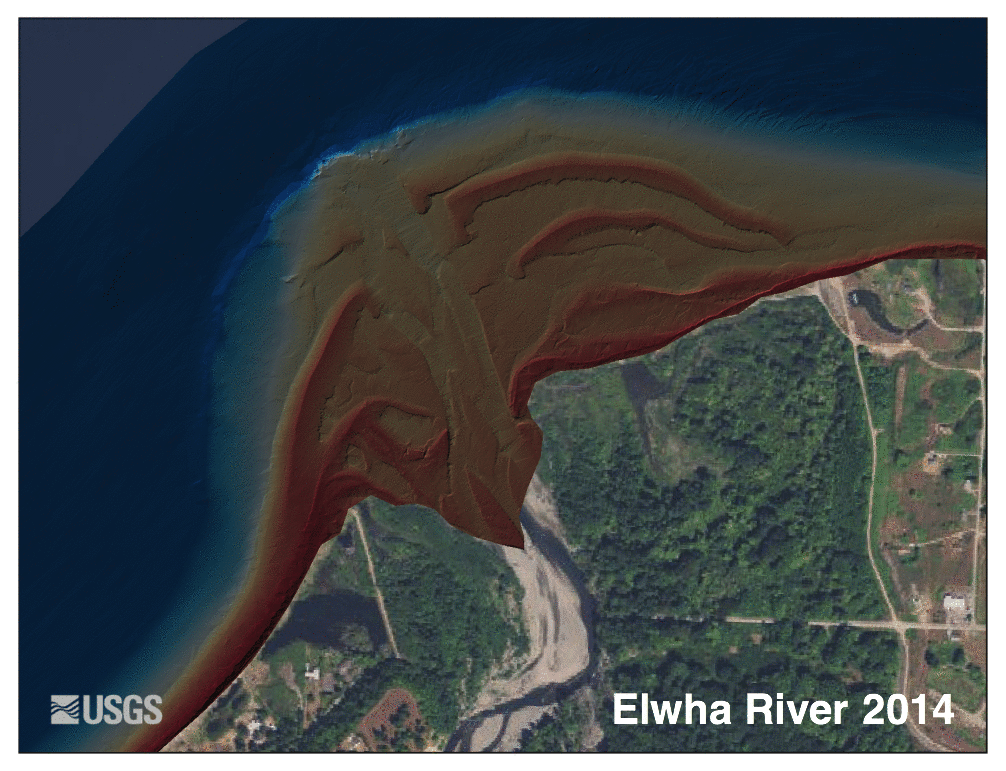
Computer animation showing changes at the mouth of the Elwha River from 2011 through 2016. Brown-shaded areas are elevations above low tide; blue shades indicate seafloor depths below low tide. Watch the animation loop to see the mouth of the Elwha River grow and change as millions of tons of sediment moved downstream from Olympic National Park to the Pacific Ocean.
This Sept. 26, 2012 image from a USGS unoccupied aircraft shows the demolition of Glines Dam and Lake Mills on the Elwha River in Olympic National Park, Washington.
From 2011 to 2014, the Nation’s largest dam removal project to date took place in Washington State, allowing the Elwha River to once again flow unimpeded from its origin in the Olympic Mountains to the Strait of Juan de Fuca. Nearly 100 years of sediment (30 million tons) had accumulated behind two dams, and about two-thirds of that (20 million tons) was released, dramatically affecting the river channel, surrounding estuaries, beaches, and the river mouth. USGS expertise focused on understanding and measuring the physical and ecological impacts of dam removal and recovery of this river system alongside multiple partners: Olympic National Park, Lower Elwha Klallam Tribe, Bureau of Reclamation, Washington Department of Ecology, U.S. Fish and Wildlife Service, Environmental Protection Agency, National Ocean.
USGS divers Steve Rubin and Reg Reisenbichler laying out a survey transect in the Elwha River.
The USGS Pacific Coastal and Marine Science Center's (PCMSC) diverse suite of data acquisition and analytical tools, as well as expertise, were utilized to assess the progress of the restoration project and to quickly adapt to changing circumstances. The PCMSC mapped the river mouth and seafloor before and after dam removal, and collected water and sediment samples to measure nutrients and other indicators of ecosystem health. Instruments placed on the seafloor near the river mouth measured current velocity, salinity, temperature, light levels, and the amount of sediment suspended in the water. Underwater cameras took photographs periodically to document the changing seafloor environment. Lidar technology recorded landscape changes resulting from the new sediment deposited along the river and the coast. Scuba divers surveyed marine life and habitats near the mouth of the river to evaluate the effects of the high sediment loads.
USGS research ecologist Jeff Duda collects discharge data on a side channel of the Elwha River. During early stages of the dam removal project, hundreds of thousands of tons of fine-grained sediment (mostly silts and sands), trapped for decades behind the dams, delivering new sediment to the lower river corridor.
Before dam removal, the river and coast downstream were starved of sand and gravel essential to the ecosystem that, according to tribal oral histories, formerly supported abundant shellfish. After dam removal, sand started accumulating again along these coastal habitats, helping to reverse long-term erosion. Salmon have begun to recolonize newly available river habitat upstream from both of the former dam sites. The Lower Elwha Klallam Tribe, whose creation site had been submerged since the building of the dams, has now had this culturally significant land returned to them. These are only a few of the ways in which this restoration project has impacted the lives of Washington residents and visitors.
The information gleaned and lessons learned from the extensive study of the Elwha River will inform decision-making for future dam decommissioning projects. This integration was facilitated through a USGS Powell Center working group on dam removal (2014–2015) that incorporated experiences and results from dozens of small and large dam removals into a better understanding of the effects of dam deconstruction. From this work we will be better able to predict the effects of dam removal on the landscape, wildlife, and communities, and how to best engineer these projects for the safety and well-being of local communities and their natural resources.
Two dams on the Elwha River, Washington State, USA trapped over 20 million m3 of sediment, reducing downstream sediment fluxes and contributing to erosion of the river's coastal delta. The removal of the Elwha and Glines Canyon dams between 2011 and 2014 induced massive increases in river sediment supply and provided an unprecedented opportunity to examine the response of a delta system...
This data release provides bathymetry and acoustic-backscatter data collected during a 2016 SWATHPlus-M survey offshore the Elwha River mouth, Strait of Juan de Fuca, Washington. Data were collected and processed by the U.S. Geological Survey, Pacific Coastal and Marine Science Center during field activity 2016-605-FA. This survey, along with two other surveys (Cochrane and others, 2008...
Time-series data of velocity, pressure, turbidity, conductivity, and temperature were collected near the mouth of the Elwha River, Washington, USA, from December 2010 through October 2014, for the Department of Interiors Elwha River Restoration project. As part of this project, the U.S. Geological Survey studied the effects of renewed sediment supplies on the coastal ecosystems before...
Two dams on the Elwha River, Washington State, USA trapped over 20 million cubic meters of sediment, reducing downstream sediment fluxes and contributing to erosion of the river's coastal delta. The removal of the Elwha and Glines Canyon dams between 2011 and 2014 induced massive increases in river sediment supply and provided an unprecedented opportunity to examine the response of a...
We characterized seafloor sediment conditions near the mouth of the Elwha River from underwater photographs taken every four hours from September 2011 to December 2013. A digital camera was affixed to a tripod that was deployed in approximately 10 meters of water (Tripod location from September 2011 to April 2013: 48.15333, -123.55931; tripod location from April 2013 to December 2013: 48...
Elwha River floating weir: a tool to study adult salmon during and following dam removal
This video introduces a multi-agency team of scientists and their project to install and operate a resistance board floating weir in the Elwha River. The weir is a fish trap used within a larger program for monitoring salmon populations in the Nation's largest dam removal and river restoration project.
This video introduces a multi-agency team of scientists and their project to install and operate a resistance board floating weir in the Elwha River. The weir is a fish trap used within a larger program for monitoring salmon populations in the Nation's largest dam removal and river restoration project.
This video shows a virtual fly-through of a detailed, highly accurate three-dimensional model of the lower Elwha River, Washington. The video begins about 0.8 river kilometers upstream (south) of the bridge on Elwha River Road.
This video shows a virtual fly-through of a detailed, highly accurate three-dimensional model of the lower Elwha River, Washington. The video begins about 0.8 river kilometers upstream (south) of the bridge on Elwha River Road.
Rivers provide important sediment inputs to many littoral cells, thereby replenishing sand and gravel of beaches around the world. However, there is limited information about the patterns and processes of littoral-grade sediment transfer from rivers into coastal systems. Here I address these information gaps by examining topographic and bathymetric data of river mouths and constructing...
Coastal erosion outpaces land generation along many of the world’s deltas and a significant percentage of shorelines, and human-caused alterations to coastal sediment budgets can be important drivers of this erosion. For sediment-starved and erosion-prone coasts, large-scale enhancement of sediment supply may be an important, but poorly understood, management option. Here we provide new
Authors
Jonathan A. Warrick, Andrew W. Stevens, Ian M. Miller, Shawn R Harrison, Andrew C. Ritchie, Guy R. Gelfenbaum
Four dams in the Klamath River Hydroelectric Project (KHP) in Oregon and California (Figure 1) are currently scheduled to be removed over a period of a few weeks or months, beginning in January 2021. The Klamath dam removal will be the largest in the world by almost all measures, and is an unprecedented opportunity to advance science of river responses to such events. The KHP contains
Authors
Chauncey W. Anderson, Scott Wright, Liam N. Schenk, Katherine Skalak, Jennifer A. Curtis, Amy E. East, Adam J. Benthem
One of the desired outcomes of dam decommissioning and removal is the recovery of aquatic and riparian ecosystems. To investigate this common objective, we synthesized information from empirical studies and ecological theory into conceptual models that depict key physical and biological links driving ecological responses to removing dams. We define models for three distinct spatial...
Authors
J. Ryan Bellmore, George R. Pess, Jeffrey J. Duda, Jim E. O'Connor, Amy E. East, Melissa M. Foley, Andrew C. Wilcox, Jon J. Major, Patrick B. Shafroth, Sarah A. Morley, Christopher S. Magirl, Chauncey W. Anderson, James E. Evans, Christian E. Torgersen, Laura S. Craig
Understanding river response to sediment pulses is a fundamental problem in geomorphic process studies, with myriad implications for river management. However, because large sediment pulses are rare and usually unanticipated, they are seldom studied at field scale. We examine fluvial response to a massive (~20 Mt) sediment pulse released by the largest dam removal globally, on the Elwha...
Authors
Amy E. East, Joshua B. Logan, Mark C. Mastin, Andrew C. Ritchie, Jennifer A. Bountry, Christopher S. Magirl, Joel B. Sankey
Given the present and future changing climate and human changes to land use and river control, river sediment fluxes to coastal systems are changing and will continue to change in the future. To delineate these changes and their effects, it is increasingly important to document the fluxes of river-borne sediment discharged to the sea. Unfortunately, broad-scale river sediment monitoring...
Dam removal provides a valuable opportunity to measure the fluvial response to changes in both sediment supply and the processes that shape channel morphology. We present the first study of river response to the removal of a large (32‐m‐high) dam in a Mediterranean hydroclimatic setting, on the Carmel River, coastal California, USA. This before‐after/control‐impact study measured changes...
Authors
Lee R. Harrison, Amy E. East, Douglas P. Smith, Joshua B. Logan, Rosealea Bond, Colin L. Nicol, Thomas H. Williams, David A. Boughton, Kaitlyn Chow, Lauren Luna
Sediment pulses can cause widespread, complex changes to rivers and coastal regions. Quantifying landscape response to sediment-supply changes is a long-standing problem in geomorphology, but the unanticipated nature of most sediment pulses rarely allows for detailed measurement of associated landscape processes and evolution. The intentional removal of two large dams on the Elwha River
Authors
Andrew C. Ritchie, Jonathan A. Warrick, Amy E. East, Christopher S. Magirl, Andrew W. Stevens, Jennifer A. Bountry, Timothy J. Randle, Christopher A. Curran, Robert C. Hilldale, Jeffrey J. Duda, Ian M. Miller, George R. Pess, Emily Eidam, Melissa M. Foley, Randall McCoy, Andrea S. Ogston
The coastal marine ecosystem near the Elwha River was altered by a massive sediment influx—over 10 million tonnes—during the staged three-year removal of two hydropower dams. We used time series of bathymetry, substrate grain size, remotely sensed turbidity, scuba dive surveys, and towed video observations collected before and during dam removal to assess responses of the nearshore...
Authors
Stephen P. Rubin, Ian M. Miller, Melissa M. Foley, Helen D. Berry, Jeffrey J. Duda, Benjamin Hudson, Nancy E. Elder, Matthew M. Beirne, Jonathan A. Warrick, Michael L. McHenry, Andrew W. Stevens, Emily Eidam, Andrea Ogston, Guy R. Gelfenbaum, Rob Pedersen
The removal of the Elwha and Glines Canyon dams from the Elwha River in Washington, USA, resulted in the erosion and transport of over 10 million m3 of sediment from the former reservoirs and into the river during the first two years of the dam removal process. Approximately 90% of this sediment was transported through the Elwha River and to the coast at the Strait of Juan de Fuca. To...
Recent decades have seen a marked increase in the number of dams removed in the United States. Investigations following a number of removals are beginning to inform how, and how fast, rivers and their ecosystems respond to released sediment. Though only a few tens of studies detail physical responses to removals, common findings have begun to emerge. They include: (1) Rivers are...
Authors
Jon J. Major, Amy E. East, Jim E. O'Connor, Gordon E. Grant, Andrew C. Wilcox, Christopher S. Magirl, Matthias J. Collins, Desiree D. Tullos
The Dam Removal Information Portal (DRIP) is an online representation and visualization tool for the USGS Dam Removal Science Database, and provides a map-based visualization of information of dam removals and associated scientific studies.
Moving Mountains: Elwha River Still Changing Five Years After World’s Largest Dam-Removal Project: More than 20 million tons of sediment flushed to the sea
Starting in 2011, the National Park Service removed two obsolete dams from the Elwha River in Olympic National Park, Washington. It was the world’s...
Undamming Washington’s Elwha River—Public Lecture on Largest Dam Removal in U.S. History
On February 26, 2015 at the USGS campus in Menlo Park, California, USGS research geologist Amy East gave a public lecture on the largest dam removal...
The Elwha River Restoration Project has reconnected the water, salmon, and sediment of a pristine river and coast of the Olympic Peninsula of Washington.
Coordinated by the National Park Service, restoration of the Elwha River included the removal of two large dams that had blocked salmon and sediment passage for almost 100 years. The largest dam removal in U.S. history began in September 2011 and concluded in the summer of 2014. Salmon are once again spawning in pristine river habitats of the Olympic National Park, and sediment is once again flowing down the river and to the eroding shoreline.
Computer animation showing changes at the mouth of the Elwha River from 2011 through 2016. Brown-shaded areas are elevations above low tide; blue shades indicate seafloor depths below low tide. Watch the animation loop to see the mouth of the Elwha River grow and change as millions of tons of sediment moved downstream from Olympic National Park to the Pacific Ocean.
This Sept. 26, 2012 image from a USGS unoccupied aircraft shows the demolition of Glines Dam and Lake Mills on the Elwha River in Olympic National Park, Washington.
From 2011 to 2014, the Nation’s largest dam removal project to date took place in Washington State, allowing the Elwha River to once again flow unimpeded from its origin in the Olympic Mountains to the Strait of Juan de Fuca. Nearly 100 years of sediment (30 million tons) had accumulated behind two dams, and about two-thirds of that (20 million tons) was released, dramatically affecting the river channel, surrounding estuaries, beaches, and the river mouth. USGS expertise focused on understanding and measuring the physical and ecological impacts of dam removal and recovery of this river system alongside multiple partners: Olympic National Park, Lower Elwha Klallam Tribe, Bureau of Reclamation, Washington Department of Ecology, U.S. Fish and Wildlife Service, Environmental Protection Agency, National Ocean.
USGS divers Steve Rubin and Reg Reisenbichler laying out a survey transect in the Elwha River.
The USGS Pacific Coastal and Marine Science Center's (PCMSC) diverse suite of data acquisition and analytical tools, as well as expertise, were utilized to assess the progress of the restoration project and to quickly adapt to changing circumstances. The PCMSC mapped the river mouth and seafloor before and after dam removal, and collected water and sediment samples to measure nutrients and other indicators of ecosystem health. Instruments placed on the seafloor near the river mouth measured current velocity, salinity, temperature, light levels, and the amount of sediment suspended in the water. Underwater cameras took photographs periodically to document the changing seafloor environment. Lidar technology recorded landscape changes resulting from the new sediment deposited along the river and the coast. Scuba divers surveyed marine life and habitats near the mouth of the river to evaluate the effects of the high sediment loads.
USGS research ecologist Jeff Duda collects discharge data on a side channel of the Elwha River. During early stages of the dam removal project, hundreds of thousands of tons of fine-grained sediment (mostly silts and sands), trapped for decades behind the dams, delivering new sediment to the lower river corridor.
Before dam removal, the river and coast downstream were starved of sand and gravel essential to the ecosystem that, according to tribal oral histories, formerly supported abundant shellfish. After dam removal, sand started accumulating again along these coastal habitats, helping to reverse long-term erosion. Salmon have begun to recolonize newly available river habitat upstream from both of the former dam sites. The Lower Elwha Klallam Tribe, whose creation site had been submerged since the building of the dams, has now had this culturally significant land returned to them. These are only a few of the ways in which this restoration project has impacted the lives of Washington residents and visitors.
The information gleaned and lessons learned from the extensive study of the Elwha River will inform decision-making for future dam decommissioning projects. This integration was facilitated through a USGS Powell Center working group on dam removal (2014–2015) that incorporated experiences and results from dozens of small and large dam removals into a better understanding of the effects of dam deconstruction. From this work we will be better able to predict the effects of dam removal on the landscape, wildlife, and communities, and how to best engineer these projects for the safety and well-being of local communities and their natural resources.
Two dams on the Elwha River, Washington State, USA trapped over 20 million m3 of sediment, reducing downstream sediment fluxes and contributing to erosion of the river's coastal delta. The removal of the Elwha and Glines Canyon dams between 2011 and 2014 induced massive increases in river sediment supply and provided an unprecedented opportunity to examine the response of a delta system...
This data release provides bathymetry and acoustic-backscatter data collected during a 2016 SWATHPlus-M survey offshore the Elwha River mouth, Strait of Juan de Fuca, Washington. Data were collected and processed by the U.S. Geological Survey, Pacific Coastal and Marine Science Center during field activity 2016-605-FA. This survey, along with two other surveys (Cochrane and others, 2008...
Time-series data of velocity, pressure, turbidity, conductivity, and temperature were collected near the mouth of the Elwha River, Washington, USA, from December 2010 through October 2014, for the Department of Interiors Elwha River Restoration project. As part of this project, the U.S. Geological Survey studied the effects of renewed sediment supplies on the coastal ecosystems before...
Two dams on the Elwha River, Washington State, USA trapped over 20 million cubic meters of sediment, reducing downstream sediment fluxes and contributing to erosion of the river's coastal delta. The removal of the Elwha and Glines Canyon dams between 2011 and 2014 induced massive increases in river sediment supply and provided an unprecedented opportunity to examine the response of a...
We characterized seafloor sediment conditions near the mouth of the Elwha River from underwater photographs taken every four hours from September 2011 to December 2013. A digital camera was affixed to a tripod that was deployed in approximately 10 meters of water (Tripod location from September 2011 to April 2013: 48.15333, -123.55931; tripod location from April 2013 to December 2013: 48...
Elwha River floating weir: a tool to study adult salmon during and following dam removal
This video introduces a multi-agency team of scientists and their project to install and operate a resistance board floating weir in the Elwha River. The weir is a fish trap used within a larger program for monitoring salmon populations in the Nation's largest dam removal and river restoration project.
This video introduces a multi-agency team of scientists and their project to install and operate a resistance board floating weir in the Elwha River. The weir is a fish trap used within a larger program for monitoring salmon populations in the Nation's largest dam removal and river restoration project.
This video shows a virtual fly-through of a detailed, highly accurate three-dimensional model of the lower Elwha River, Washington. The video begins about 0.8 river kilometers upstream (south) of the bridge on Elwha River Road.
This video shows a virtual fly-through of a detailed, highly accurate three-dimensional model of the lower Elwha River, Washington. The video begins about 0.8 river kilometers upstream (south) of the bridge on Elwha River Road.
Rivers provide important sediment inputs to many littoral cells, thereby replenishing sand and gravel of beaches around the world. However, there is limited information about the patterns and processes of littoral-grade sediment transfer from rivers into coastal systems. Here I address these information gaps by examining topographic and bathymetric data of river mouths and constructing...
Coastal erosion outpaces land generation along many of the world’s deltas and a significant percentage of shorelines, and human-caused alterations to coastal sediment budgets can be important drivers of this erosion. For sediment-starved and erosion-prone coasts, large-scale enhancement of sediment supply may be an important, but poorly understood, management option. Here we provide new
Authors
Jonathan A. Warrick, Andrew W. Stevens, Ian M. Miller, Shawn R Harrison, Andrew C. Ritchie, Guy R. Gelfenbaum
Four dams in the Klamath River Hydroelectric Project (KHP) in Oregon and California (Figure 1) are currently scheduled to be removed over a period of a few weeks or months, beginning in January 2021. The Klamath dam removal will be the largest in the world by almost all measures, and is an unprecedented opportunity to advance science of river responses to such events. The KHP contains
Authors
Chauncey W. Anderson, Scott Wright, Liam N. Schenk, Katherine Skalak, Jennifer A. Curtis, Amy E. East, Adam J. Benthem
One of the desired outcomes of dam decommissioning and removal is the recovery of aquatic and riparian ecosystems. To investigate this common objective, we synthesized information from empirical studies and ecological theory into conceptual models that depict key physical and biological links driving ecological responses to removing dams. We define models for three distinct spatial...
Authors
J. Ryan Bellmore, George R. Pess, Jeffrey J. Duda, Jim E. O'Connor, Amy E. East, Melissa M. Foley, Andrew C. Wilcox, Jon J. Major, Patrick B. Shafroth, Sarah A. Morley, Christopher S. Magirl, Chauncey W. Anderson, James E. Evans, Christian E. Torgersen, Laura S. Craig
Understanding river response to sediment pulses is a fundamental problem in geomorphic process studies, with myriad implications for river management. However, because large sediment pulses are rare and usually unanticipated, they are seldom studied at field scale. We examine fluvial response to a massive (~20 Mt) sediment pulse released by the largest dam removal globally, on the Elwha...
Authors
Amy E. East, Joshua B. Logan, Mark C. Mastin, Andrew C. Ritchie, Jennifer A. Bountry, Christopher S. Magirl, Joel B. Sankey
Given the present and future changing climate and human changes to land use and river control, river sediment fluxes to coastal systems are changing and will continue to change in the future. To delineate these changes and their effects, it is increasingly important to document the fluxes of river-borne sediment discharged to the sea. Unfortunately, broad-scale river sediment monitoring...
Dam removal provides a valuable opportunity to measure the fluvial response to changes in both sediment supply and the processes that shape channel morphology. We present the first study of river response to the removal of a large (32‐m‐high) dam in a Mediterranean hydroclimatic setting, on the Carmel River, coastal California, USA. This before‐after/control‐impact study measured changes...
Authors
Lee R. Harrison, Amy E. East, Douglas P. Smith, Joshua B. Logan, Rosealea Bond, Colin L. Nicol, Thomas H. Williams, David A. Boughton, Kaitlyn Chow, Lauren Luna
Sediment pulses can cause widespread, complex changes to rivers and coastal regions. Quantifying landscape response to sediment-supply changes is a long-standing problem in geomorphology, but the unanticipated nature of most sediment pulses rarely allows for detailed measurement of associated landscape processes and evolution. The intentional removal of two large dams on the Elwha River
Authors
Andrew C. Ritchie, Jonathan A. Warrick, Amy E. East, Christopher S. Magirl, Andrew W. Stevens, Jennifer A. Bountry, Timothy J. Randle, Christopher A. Curran, Robert C. Hilldale, Jeffrey J. Duda, Ian M. Miller, George R. Pess, Emily Eidam, Melissa M. Foley, Randall McCoy, Andrea S. Ogston
The coastal marine ecosystem near the Elwha River was altered by a massive sediment influx—over 10 million tonnes—during the staged three-year removal of two hydropower dams. We used time series of bathymetry, substrate grain size, remotely sensed turbidity, scuba dive surveys, and towed video observations collected before and during dam removal to assess responses of the nearshore...
Authors
Stephen P. Rubin, Ian M. Miller, Melissa M. Foley, Helen D. Berry, Jeffrey J. Duda, Benjamin Hudson, Nancy E. Elder, Matthew M. Beirne, Jonathan A. Warrick, Michael L. McHenry, Andrew W. Stevens, Emily Eidam, Andrea Ogston, Guy R. Gelfenbaum, Rob Pedersen
The removal of the Elwha and Glines Canyon dams from the Elwha River in Washington, USA, resulted in the erosion and transport of over 10 million m3 of sediment from the former reservoirs and into the river during the first two years of the dam removal process. Approximately 90% of this sediment was transported through the Elwha River and to the coast at the Strait of Juan de Fuca. To...
Recent decades have seen a marked increase in the number of dams removed in the United States. Investigations following a number of removals are beginning to inform how, and how fast, rivers and their ecosystems respond to released sediment. Though only a few tens of studies detail physical responses to removals, common findings have begun to emerge. They include: (1) Rivers are...
Authors
Jon J. Major, Amy E. East, Jim E. O'Connor, Gordon E. Grant, Andrew C. Wilcox, Christopher S. Magirl, Matthias J. Collins, Desiree D. Tullos
The Dam Removal Information Portal (DRIP) is an online representation and visualization tool for the USGS Dam Removal Science Database, and provides a map-based visualization of information of dam removals and associated scientific studies.
Moving Mountains: Elwha River Still Changing Five Years After World’s Largest Dam-Removal Project: More than 20 million tons of sediment flushed to the sea
Starting in 2011, the National Park Service removed two obsolete dams from the Elwha River in Olympic National Park, Washington. It was the world’s...
Undamming Washington’s Elwha River—Public Lecture on Largest Dam Removal in U.S. History
On February 26, 2015 at the USGS campus in Menlo Park, California, USGS research geologist Amy East gave a public lecture on the largest dam removal...