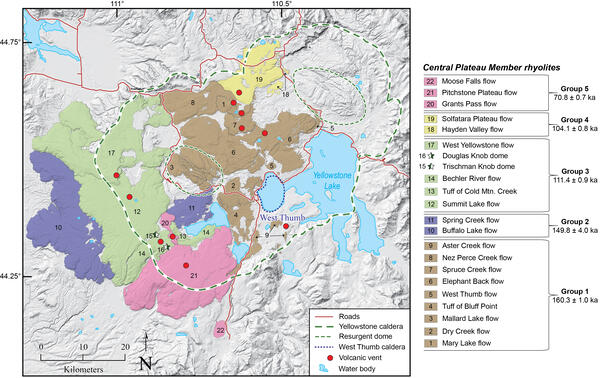
U.S. flag

An official website of the United States government

Images

Volcano Science Center images.

Filter Total Items: 534
View of a meadow with a mountain range (the eastern front of the Gallatin Range) in the background under a blue sky
Eastern front of the Gallatin Range as viewed from Gardners Hole in Yellowstone National Park

View to the southwest of the eastern front of the Gallatin Range from Gardners Hole. The East Gallatin-Reese Creek fault system runs along the base of the range at the prominent break-in-slope in the trees. Photo by James Mauch, Wyoming State Geological Survey, on August 29, 2023.

View to the southwest of the eastern front of the Gallatin Range from Gardners Hole. The East Gallatin-Reese Creek fault system runs along the base of the range at the prominent break-in-slope in the trees. Photo by James Mauch, Wyoming State Geological Survey, on August 29, 2023.

A portion of organic-rich lake mud recovered from Rush Lake, Lower Geyser Basin, Yellowstone National Park

A portion of organic-rich lake mud recovered from Rush Lake, in the Lower Geyser Basin of Yellowstone National Park. Younger sediments are to the left and older sediments are to the right. The researcher is pointing to a thin, white layer—the Mazama ash, produced during the eruption 7600 years ago that formed Crater Lake in Oregon.

A portion of organic-rich lake mud recovered from Rush Lake, in the Lower Geyser Basin of Yellowstone National Park. Younger sediments are to the left and older sediments are to the right. The researcher is pointing to a thin, white layer—the Mazama ash, produced during the eruption 7600 years ago that formed Crater Lake in Oregon.

Several pieces of large construction equipment, including two cranes and a cement mixer, in a cleared area among trees.  A grass and tree-covered hill rises in the background.
Pouring cement for a footer of the new Yellowstone River Bridge

Pouring sulfate-resistant cement for one of the bridge footers after a drill hole has been completed. The existing bridge can be seen through the trees on the left side of the picture.

Pouring sulfate-resistant cement for one of the bridge footers after a drill hole has been completed. The existing bridge can be seen through the trees on the left side of the picture.

Three construction workers stand around construction equipment, including a drill.
Drilling for the new Yellowstone River Bridge near Tower Junction

Drilling for the new Yellowstone River Bridge near Tower Junction. A small, yellow, personal 4-gas safety monitor can be seen on the upper left breast pocket on the person in the far right of the picture.  Photo by Ken Sims (University of Wyoming), August 3, 2023.

Drilling for the new Yellowstone River Bridge near Tower Junction. A small, yellow, personal 4-gas safety monitor can be seen on the upper left breast pocket on the person in the far right of the picture.  Photo by Ken Sims (University of Wyoming), August 3, 2023.

River in foreground. Background is a mountainside with vertical rock layers, one of which is red
Devil’s Slide, Montana, looking across the Yellowstone River

Photo of Devil’s Slide, Montana, looking across the Yellowstone River.  The red streak is a Triassic shale layer.  Rocks to the right of the streak are older and to the left are younger.  USGS photo by Mike Poland, August 2, 2023.

Photo of Devil’s Slide, Montana, looking across the Yellowstone River.  The red streak is a Triassic shale layer.  Rocks to the right of the streak are older and to the left are younger.  USGS photo by Mike Poland, August 2, 2023.

Streamgage site and profiling tool on the Yellowstone River at Corwin Springs, Montana

Streamgage site and profiling tool on the Yellowstone River at Corwin Springs, Montana.  The gage house narrowly avoided damage during the June 2022 flood, which eroded the downstream bank.  The river profiling instrument helps to map the river bottom to assess streamflow rates and conditions.  USGS photo by Mike Poland, July 31, 2023.

Streamgage site and profiling tool on the Yellowstone River at Corwin Springs, Montana.  The gage house narrowly avoided damage during the June 2022 flood, which eroded the downstream bank.  The river profiling instrument helps to map the river bottom to assess streamflow rates and conditions.  USGS photo by Mike Poland, July 31, 2023.

Photograph showing orange fountains of lava inside a crater with orange and black lava flows filling the crater.
Screen Shot 2023-07-14 at 9.52.56 AM.png

Web camera view of the onset of the June 7 eruption of Kīlauea volcano from the summit caldera.

High-resolution satellite images of the Porcelain Basin and Nuphar Lake areas of Norris Geyser Basin

High-resolution satellite images of the Porcelain Basin and Nuphar Lake areas of Norris Geyser Basin acquired by Quickbird-2 on September 11, 2006 (left), WorldView-3 on July 7, 2016 (middle), and WorldView-3 on March 30, 2022 (right).  Note the change in color of Nuphar lake, from deep green to light blue, over time, as well as the increased evidence of flow f

High-resolution satellite images of the Porcelain Basin and Nuphar Lake areas of Norris Geyser Basin acquired by Quickbird-2 on September 11, 2006 (left), WorldView-3 on July 7, 2016 (middle), and WorldView-3 on March 30, 2022 (right).  Note the change in color of Nuphar lake, from deep green to light blue, over time, as well as the increased evidence of flow f

Visible (top) and thermal (bottom) images of Porcelain Basin

Visible (top) and thermal (bottom) images of Porcelain Basin looking to the north from the old roadbed.  Nuphar Lake is off the photograph to the right.  Cool-water seeps into Porcelain Basin are clearly evident in the thermal image and appear to flow underground from Nuphar Lake.  USGS photos by Mike Poland, July 1, 2023.

Visible (top) and thermal (bottom) images of Porcelain Basin looking to the north from the old roadbed.  Nuphar Lake is off the photograph to the right.  Cool-water seeps into Porcelain Basin are clearly evident in the thermal image and appear to flow underground from Nuphar Lake.  USGS photos by Mike Poland, July 1, 2023.

Animated GIF of the Porcelain Basin and Nuphar Lake areas of Norris Geyser Basin

High-resolution satellite images of the Porcelain Basin and Nuphar Lake areas of Norris Geyser Basin acquired by Quickbird-2 on September 11, 2006 and WorldView-3 on March 30, 2022.  Note the change in color of Nuphar lake, from deep green to light blue, over time, as well as the increased evidence of flow from thermal features on the east side of Porcelain Bas

High-resolution satellite images of the Porcelain Basin and Nuphar Lake areas of Norris Geyser Basin acquired by Quickbird-2 on September 11, 2006 and WorldView-3 on March 30, 2022.  Note the change in color of Nuphar lake, from deep green to light blue, over time, as well as the increased evidence of flow from thermal features on the east side of Porcelain Bas

Comparison between the velocity structures outlining the Yellowstone’s upper-crustal magma reservoir at 5 km (3 mi) depth based on sparse (left) and dense (right) seismic networks
Velocity structures outlining the Yellowstone’s upper-crustal magma reservoir based on sparse (left) and dense (right) seismic networks

Comparison between the velocity structures outlining the Yellowstone’s upper-crustal magma reservoir at 5 km (3 mi) depth based on sparse (left) and dense (right) seismic networks. The open squares denote the locations of seismic sensors. Warmer color indicates lower velocity, representing higher melt fraction within the medium.

Color graphics of earthquakes
Map of American Samoa volcano-monitoring network.

Map of the American Samoa volcano-monitoring network (top). Data from Wake Island hydrograph (located about 4,500 km, or 2,900 miles, northwest of Taʻū Island) shows the general trend in the number of events during the 2022 earthquake swarm (bottom left). Locations for larger earthquakes (M2.5 and greater) are available starting August 20, 2022 (bottom right).

Map of the American Samoa volcano-monitoring network (top). Data from Wake Island hydrograph (located about 4,500 km, or 2,900 miles, northwest of Taʻū Island) shows the general trend in the number of events during the 2022 earthquake swarm (bottom left). Locations for larger earthquakes (M2.5 and greater) are available starting August 20, 2022 (bottom right).

Map of Norris Geyser Basin

Map of Norris Geyser Basin showing the locations of major subbasins, roads and trails, and Nuphar Lake.

Map of Norris Geyser Basin showing the locations of major subbasins, roads and trails, and Nuphar Lake.

Woman receiving lei from a man.
Interior Secretary, Deb Haaland, presented with lei.

Interior Secretary, Deb Haaland, presented with lei by David Phillips, Deputy Scientist-in-Charge of the USGS Hawaiian Volcano Observatory, during a ceremony to celebrate the creation of a new facility that will monitor volcanoes and support conservation science.

Interior Secretary, Deb Haaland, presented with lei by David Phillips, Deputy Scientist-in-Charge of the USGS Hawaiian Volcano Observatory, during a ceremony to celebrate the creation of a new facility that will monitor volcanoes and support conservation science.

People sitting on a lawn during a ceremony
Celebration for the creation of a new USGS facility

Federal, state, local and University of Hawai´i leaders and students celebrate the creation of a new facility that will monitor volcanoes and support conservation science.

Earthquake Lake and the Madison slide

Earthquake Lake, which formed when the Madison River was blocked by a landslide that occurred as a consequence of the Hebgen Lake earthquake in 1959.  The lake inundated existing forest, now marked by standing dead trees in the lake water. The landslide scar is visible on the side of the mountain at the far end of the lake.

Earthquake Lake, which formed when the Madison River was blocked by a landslide that occurred as a consequence of the Hebgen Lake earthquake in 1959.  The lake inundated existing forest, now marked by standing dead trees in the lake water. The landslide scar is visible on the side of the mountain at the far end of the lake.

Map of Geyser Hill, Upper Geyser Basin, Yellowstone National Park, with selected thermal features

Map of Geyser Hill, Upper Geyser Basin, Yellowstone National Park, showing selected thermal features, including new and reactivated features that were active during the May-June 2023 thermal unrest.  Map prepared by by Kiernan Folz-Donahue, Yellowstone National Park.

A small snake extends out from tall green grass over a stream.
Garter snake along Violet Creek near the Mary Mountain Trail in Hayden Valley, Yellowstone National Park

A garter snake along Violet Creek near the Mary Mountain Trail in Hayden Valley, Yellowstone National Park. This snake used the geothermally warmed creek to thermoregulate during near-freezing overnight conditions. USGS photo by Stanley Mordensky, June 2023.

Was this page helpful?