
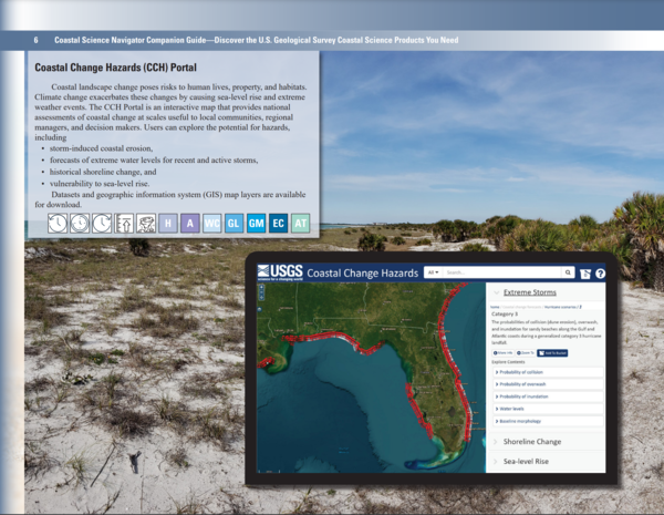
Coastal Change Hazards Portal page of the Coastal Science Navigator Companion Guide.
Multimedia
Multimedia products produced by Woods Hole Coastal and Marine Science Center staff
Images
Companion Guide - CCH Portal page
Coastal Change Hazards Portal page of the Coastal Science Navigator Companion Guide.

Companion Guide - CCL page
The Coastal Change Likelihood Website page of the Coastal Science Navigator Companion Guide.
The Coastal Change Likelihood Website page of the Coastal Science Navigator Companion Guide.

Companion Guide - U.S. Coastal Wetlands Synthesis
The U.S. Coastal Wetlands Synthesis page of the Coastal Science Navigator Companion Guide.
The U.S. Coastal Wetlands Synthesis page of the Coastal Science Navigator Companion Guide.
Icon Page
The Coastal Science Navigator Companion Guide introduces you to USGS coastal change hazards-related products—including interactive data maps, downloadable software, geonarratives, and more. It's organized by timescale, highlighting products relevant to the present, past, and future, although many cover multiple timescales.
The Coastal Science Navigator Companion Guide introduces you to USGS coastal change hazards-related products—including interactive data maps, downloadable software, geonarratives, and more. It's organized by timescale, highlighting products relevant to the present, past, and future, although many cover multiple timescales.
Companion Guide
Screenshots from the Coastal Science Navigator Companion Guide overlaid on top of image of the Army Corps of Engineers Field Research Facility pier near Kitty Hawk, North Carolina.
Screenshots from the Coastal Science Navigator Companion Guide overlaid on top of image of the Army Corps of Engineers Field Research Facility pier near Kitty Hawk, North Carolina.

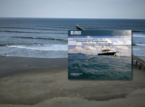
Companion Guide Cover
Cover of the Coastal Science Navigator Companion Guide. The guide introduces some of the many coastal change hazards-related products available through the USGS. In it, we showcase the products included in the Coastal Science Navigator’s initial publication in July 2023.
Cover of the Coastal Science Navigator Companion Guide. The guide introduces some of the many coastal change hazards-related products available through the USGS. In it, we showcase the products included in the Coastal Science Navigator’s initial publication in July 2023.
Videos

The USGS Northeast Region: Delivering Science for Better Decisions
This video is an introduction of the USGS Northeast Region's science efforts to support society's evolving needs through its engaged and diverse workforce.
This video is an introduction of the USGS Northeast Region's science efforts to support society's evolving needs through its engaged and diverse workforce.

Introduction to the USGS Coastal Science Navigator
The Coastal Science Navigator is intended to help users discover USGS Coastal Change Hazards information, products, and tools relevant to their scientific or decision-making needs.
The Coastal Science Navigator is intended to help users discover USGS Coastal Change Hazards information, products, and tools relevant to their scientific or decision-making needs.

Flyover of the U.S. Coastline
Our Nation’s coastlines are almost 100,000 miles long. These extensive coastal areas stretch from Maine’s Atlantic shores in the northeast, south along the shores of the Gulf of Mexico and insular areas in the Caribbean.
Our Nation’s coastlines are almost 100,000 miles long. These extensive coastal areas stretch from Maine’s Atlantic shores in the northeast, south along the shores of the Gulf of Mexico and insular areas in the Caribbean.

Assateague Island National Seashore
sUAS coastal Imagery collected by the Woods Hole Coastal and Marine Science Center Aerial Imaging and Mapping group (AIM) at Assateague Island National Seashore October 10-14th, 2022.
sUAS coastal Imagery collected by the Woods Hole Coastal and Marine Science Center Aerial Imaging and Mapping group (AIM) at Assateague Island National Seashore October 10-14th, 2022.
Webcams

Pea Island video camera 1 snapshot
Two video cameras are temporarily mounted on a dune at Pea Island National Wildlife Refuge on the Outer Banks of North Carolina. The cameras are imaging the southern DUNEX (DUring Nearshore Event eXperiment) experiment site, and are designed to have a stereo view of the beach and potential overwash path until late October. Instruments from the U.S.
Two video cameras are temporarily mounted on a dune at Pea Island National Wildlife Refuge on the Outer Banks of North Carolina. The cameras are imaging the southern DUNEX (DUring Nearshore Event eXperiment) experiment site, and are designed to have a stereo view of the beach and potential overwash path until late October. Instruments from the U.S.

Pea Island video camera 2 snapshot
Two video cameras are temporarily mounted on a dune at Pea Island National Wildlife Refuge on the Outer Banks of North Carolina. The cameras are imaging the southern DUNEX (DUring Nearshore Event eXperiment) experiment site, and are designed to have a stereo view of the beach and potential overwash path until late October. Instruments from the U.S.
Two video cameras are temporarily mounted on a dune at Pea Island National Wildlife Refuge on the Outer Banks of North Carolina. The cameras are imaging the southern DUNEX (DUring Nearshore Event eXperiment) experiment site, and are designed to have a stereo view of the beach and potential overwash path until late October. Instruments from the U.S.
Marconi Beach video camera 1 dark image
Two video cameras are mounted on a bluff above Marconi Beach, Cape Cod National Seashore, Wellfleet, MA. Every half hour, the video cameras collect imagery for 10 minutes. This is the “dark” image, the darkest pixel values throughout the video, useful for tracking sediment plumes, tracking floating debris, and filtering out breaking waves.
Two video cameras are mounted on a bluff above Marconi Beach, Cape Cod National Seashore, Wellfleet, MA. Every half hour, the video cameras collect imagery for 10 minutes. This is the “dark” image, the darkest pixel values throughout the video, useful for tracking sediment plumes, tracking floating debris, and filtering out breaking waves.
Marconi Beach video camera 2 dark image
Two video cameras are mounted on a bluff above Marconi Beach, Cape Cod National Seashore, Wellfleet, MA. Every half hour, the video cameras collect imagery for 10 minutes. This is the “dark” image, the darkest pixel values throughout the video, useful for tracking sediment plumes, tracking floating debris, and filtering out breaking waves.
Two video cameras are mounted on a bluff above Marconi Beach, Cape Cod National Seashore, Wellfleet, MA. Every half hour, the video cameras collect imagery for 10 minutes. This is the “dark” image, the darkest pixel values throughout the video, useful for tracking sediment plumes, tracking floating debris, and filtering out breaking waves.

Marconi Beach video camera 1 variance image
Two video cameras are mounted on a bluff above Marconi Beach, Cape Cod National Seashore, Wellfleet, MA. Every half hour, the video cameras collect imagery for 10 minutes.
Two video cameras are mounted on a bluff above Marconi Beach, Cape Cod National Seashore, Wellfleet, MA. Every half hour, the video cameras collect imagery for 10 minutes.

Marconi Beach video camera 2 variance image
Two video cameras are mounted on a bluff above Marconi Beach, Cape Cod National Seashore, Wellfleet, MA. Every half hour, the video cameras collect imagery for 10 minutes.
Two video cameras are mounted on a bluff above Marconi Beach, Cape Cod National Seashore, Wellfleet, MA. Every half hour, the video cameras collect imagery for 10 minutes.