



How We Use Water
How We Use Water
Water Use in the United States
Integrated Water Availability Assessments (IWAAs)
USGS announces 10 IWAAs pilot projects
Supporting the development of national and regional Integrated Water Availability Assessments
Supporting the development of national and regional Integrated Water Availability Assessments
Find water science information and activities related to the different ways we use water.
National Water Availability Assessment Data Companion
National Water Availability Assessment Data Companion

The Data Companion provides model-based estimates of water availability and use.
Data Visualization of Water Use in the U.S. 2015
Data Visualization of Water Use in the U.S. 2015
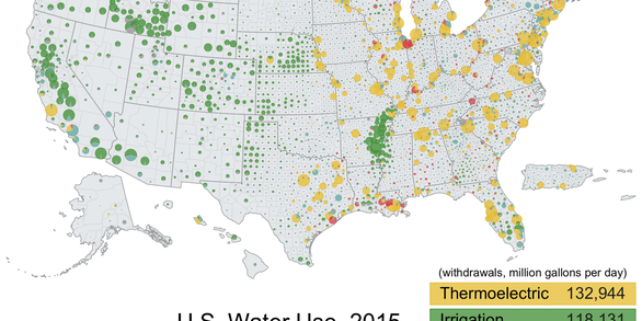
Explore water use data by state and county for 2015
Filter Total Items: 101

Public Supply Water Use
Public supply refers to water withdrawn by public and private water suppliers that provide water to at least 25 people or have a minimum of 15 connections to users. Public supply water is delivered for domestic (residential), commercial, and industrial purposes.

Domestic Self-Supplied Water Use
Domestic self-supplied water is water used at home that does not come from a public water utility. This can include potable and non-potable water. The most common source of self-supplied water is a well. Other self-supplied water sources include capturing rainwater in a cistern, private surface water diversions (intakes), piping spring water to a home or outdoor faucet, or hauling jugs of water...

Accessing Water Use Data
The USGS provides historic and recent water use data for the United States including the District of Columbia, Puerto Rico, and the U.S. Virgin Islands. This page provides an up-to-date guide to accessing, downloading, and using USGS water use data.

Water Use in the United States
Since 1950, the USGS has regularly produced nationwide water‑use data, creating one of the most comprehensive pictures of how water is used across the United States. Building on this rich historical record, these data give water managers a critical foundation to evaluate long‑term trends, plan strategically, and identify and quantify water availability so they can design more adaptive, resilient...

Thermoelectric Power Water Use
Much of the electricity used in the United States and worldwide comes from thermoelectric power plants, which use water for both steam generation and cooling. Thermoelectric power consumes, or loses water via evaporation, at rates that can be significant—especially in water-stressed regions.

Irrigation Water Use
Throughout the world, irrigation (water for agriculture) is essential for keeping fruits, vegetables, and grains growing to feed the world's population. In addition, irrigation can alleviate crop stress from droughts, decrease soil erosion, and can reduce water pollution. USGS scientists provide estimates of irrigation water use to help water managers make informed decisions.

Integrated Water Science Basins: Willamette River
The Willamette River Basin reflects the conflicting water demands between humans and ecosystems—particularly salmon— and the challenge resource managers face throughout the Pacific Northwest.

Centennial Streamgages
Centennial Streamgages are USGS streamgages that have been in operation for more than 100 years.

National Water Availability Assessments
The USGS National Water Availability Assessment consists of reports, which provide a scientific summary and interpretation of water quantity, quality and use, and the data companion, which delivers model-based estimates of water supply and demand.

Regional Water Availability Assessments
Regional Water Availability Assessments are scientific assessments of water availability in different hydrologic regions across the Nation. They are designed to capture a range of conditions in major drivers of water availability.

Integrated Water Availability Assessments
The USGS Water Resources Mission Area is assessing how much water is available for human and ecological needs in the United States and identifying where and when the Nation may have challenges meeting its demand for water.

Integrated Water Availability Assessments Fundamentals
The USGS Water Resources Mission Area is assessing how much water is available for human and ecological needs in the United States and identifying where and when the Nation may have challenges meeting its demand for water.