
How We Use Water
How We Use Water
Water Use in the United States
Integrated Water Availability Assessments (IWAAs)
USGS announces 10 IWAAs pilot projects
Supporting the development of national and regional Integrated Water Availability Assessments
Supporting the development of national and regional Integrated Water Availability Assessments
Find water science information and activities related to the different ways we use water.
National Water Availability Assessment Data Companion
National Water Availability Assessment Data Companion

The Data Companion provides model-based estimates of water availability and use.
Data Visualization of Water Use in the U.S. 2015
Data Visualization of Water Use in the U.S. 2015
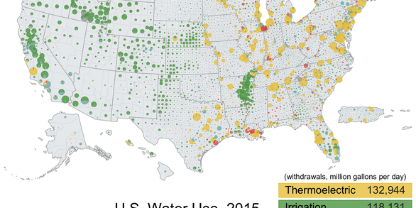
Explore water use data by state and county for 2015
Filter Total Items: 102

Accessing Water Use Data
The USGS provides historic and recent water use data for the United States including the District of Columbia, Puerto Rico, and the U.S. Virgin Islands. This page provides an up-to-date guide to accessing, downloading, and using USGS water use data.

Water Use in the United States
Since 1950, the USGS has regularly produced nationwide water‑use data, creating one of the most comprehensive pictures of how water is used across the United States. Building on this rich historical record, these data give water managers a critical foundation to evaluate long‑term trends, plan strategically, and identify and quantify water availability so they can design more adaptive, resilient...

National Water Availability Assessments
The USGS National Water Availability Assessment consists of reports, which provide a scientific summary and interpretation of water quantity, quality and use, and the data companion, which delivers model-based estimates of water supply and demand.

Regional Water Availability Assessments
Regional Water Availability Assessments are scientific assessments of water availability in different hydrologic regions across the Nation. They are designed to capture a range of conditions in major drivers of water availability.

Integrated Water Availability Assessments
The USGS Water Resources Mission Area is assessing how much water is available for human and ecological needs in the United States and identifying where and when the Nation may have challenges meeting its demand for water.

Integrated Water Availability Assessments Fundamentals
The USGS Water Resources Mission Area is assessing how much water is available for human and ecological needs in the United States and identifying where and when the Nation may have challenges meeting its demand for water.

National Water Availability Assessment Data Companion
The National Water Availability Assessment Data Companion (NWDC) delivers model-based estimates of water supply and demand.

Withdrawals for Bottled Water
USGS is compiling data on locations and volumes of water withdrawals for bottled water production and learning how, when, and where bottled water withdrawals result in changes to groundwater levels, spring flows, and water quality.

USGS National Streamgaging Network
As of October 2024, the USGS Groundwater and Streamflow Information Program supports the collection and (or) delivery of both streamflow and water-level information at 8,705 sites and water-level information alone at 3,460 additional sites. The data are served online—most in near real-time—to meet many diverse needs including the protection of life, property, the environment, and our economy.

Centennial Streamgages
Centennial Streamgages are USGS streamgages that have been in operation for more than 100 years.

Integrated Water Science Basins: Willamette River
The Willamette River Basin reflects the conflicting water demands between humans and ecosystems—particularly salmon— and the challenge resource managers face throughout the Pacific Northwest.

Water-Quality Benchmarks for Contaminants
How does the water quality measure up? It all depends on what the water will be used for and what contaminants are of interest. Water-quality benchmarks are designed to protect drinking water, recreation, aquatic life, and wildlife. Here you’ll find links to some of the most widely used sets of water, sediment, and fish tissue benchmarks and general guidance about their interpretation.