
This image shows the spectral bandpasses for the sensors on all Landsat satellites.
Landsat 5
Landsat 5
Explore research, stories, and images featuring the satellites
Explore research, stories, and images featuring the satellites
Landsat 5 orbited the planet more than 150,000 times over the course of 28 years while transmitting over 2.5 million images of land surface conditions around the world.
Media

Sources/Usage: Public Domain. View Media Details
Developed by NASA, Landsat 5 was launched from Vandenberg Air Force Base in California on March 1, 1984, and like Landsat 4, carried the Multispectral Scanner (MSS) and the Thematic Mapper (TM) instruments. Landsat 5 delivered Earth imaging data for nearly 29 years— setting a Guinness World Record for 'Longest Operating Earth Observation Satellite,' before being decommissioned on June 5, 2013. Clearly, this satellite outlived its three-year design.
Landsat 5 Satellite Orbit Facts
- Orbited the Earth at 705 km (438 mi) in a sun-synchronous, near-polar orbit (98.2 degrees inclination)
- Circled the Earth every 99 minutes, fourteen orbits a day
Media

Sources/Usage: Public Domain. View Media Details
- Had a 16-day repeat cycle with an equatorial crossing time of 9:45 a.m. (+/- 15 minutes)
- Acquired on the Worldwide Reference System-2 (WRS-2) path/row system, with swath overlap (or sidelap) varying from 7 percent at the Equator to a maximum of approximately 85 percent at extreme latitudes.
Landsat 5 Spacecraft Facts
- 3-axis stabilized, zero momentum with control of 0.01 deg using reaction wheels
- Aluminum with graphite struts
- Hydrazine propulsion system
- Single solar array with 1-axis articulation
- Three Nickel Cadmium (NiCd) batteries provide 100 Ampere-Hour (AHr) total
- Retractable boom (4 m long) with 2 powered joints supports the articulated High Gain Antenna, which downlinks data via Tracking and Data Relay Satellite System (TDRSS)
- Communications system uses S,X,L, and Ku Bands
- Weight: approximately 4,800 lbs (2,200 kg)
Landsat 5 Instruments
Landsat 5 carried the Multispectral Scanner (MSS) and the Thematic Mapper (TM) sensors. MSS data acquisitions over the United States ceased in 1992 and global acquisitions ended in 1999. After the TM sensor failed in November 2011, the MSS instrument was brought back online. From June 2012 until January 2013, over 15,000 MSS scenes were collected.
Media

Sources/Usage: Public Domain. View Media Details
Multispectral Scanner (MSS)
- Four spectral bands (identical to Landsat 1 and 2):
- Band 1 Visible Green (0.5 to 0.6 µm)
- Band 2 Visible Red (0.6 to 0.7 µm)
- Band 3 Near-Infrared (0.7 to 0.8 µm)
- Band 4 Near-Infrared (0.8 to 1.1 µm)
- Six detectors for each spectral band provided six scan lines on each active scan
- Ground Sampling Interval (pixel size): 57 x 79 m
Visit Landsat 1-5 MSS for more information.
Thematic Mapper (TM)
- Added the mid-range infrared to the data
- Seven spectral bands, including a thermal band:
- Band 1 Visible Blue (0.45 - 0.52 µm) 30 m
- Band 2 Visible Green (0.52 - 0.60 µm) 30 m
- Band 3 Visible Red (0.63 - 0.69 µm) 30 m
- Band 4 Near-Infrared (0.76 - 0.90 µm) 30 m
- Band 5 Near-Infrared (1.55 - 1.75 µm) 30 m
- Band 6 Thermal (10.40 - 12.50 µm) 120 m
- Band 7 Mid-Infrared (2.08 - 2.35 µm) 30 m
- Ground Sampling Interval (pixel size): 30 m reflective, 120 m thermal
Visit Landsat 4-5 TM for more information.
Additional Resources
Landsat 5 History (NASA Landsat Science)
The Thematic Mapper (NASA Landsat Science)
The Multispectral Scanner (NASA Landsat Science)
Earth Observing Landsat 5 Turns 25 Years Old - March 2009 (NASA)
Landsat 5 Decommissioning Announcement - December 2012 (USGS)
The Legacy of Landsat 5 - January 2013 (USGS)
How to Manage a Satellite Going 17K MPH - May 2013 (Library of Congress)
USGS Completes Decommissioning of Landsat 5 - June 2013 (USGS)
The Final Journey of Landsat 5: A Decommissioning Story
Related

Landsat 5 First Light Image over South Texas Gulf Coast
One of the first Landsat 5 images in the archive shows Corpus Christi and Padre Island National Seashore. The image was acquired on March 6, 1984 and is shown as a false color composite using the near infrared, red, and green bands (bands 4,3,2). Learn more about the mission on the Landsat 5 web page
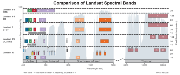
Spectral Bandpasses for all Landsat Sensors
This image shows the spectral bandpasses for the sensors on all Landsat satellites.

Landsat Played Role in Confirming 1986 Chernobyl Disaster
Landsat Played Role in Confirming 1986 Chernobyl DisasterWhen the Chernobyl Nuclear Power Plant exploded 30 years ago, on April 26, 1986, Landsat 5 was the first civilian satellite to confirm the disaster near Pripyat, Ukraine, in the agricultural heartland of the Soviet Union.

Landsat 5 MSS Image of Michigan’s Upper Peninsula
This image of Michigan’s Upper Peninsula was captured by the Multispectral Scanner (MSS) instrument onboard the Landsat 5 satellite on January 7, 2013.
This image of Michigan’s Upper Peninsula was captured by the Multispectral Scanner (MSS) instrument onboard the Landsat 5 satellite on January 7, 2013.

Landsat 5 image showing the Seattle, Washington area
Landsat 5 image showing the Seattle, Washington areaExample of the Landsat 4-5 TM Collection 2 level-1 product. This Landsat 5 image was acquired on October 6, 2010 near Seattle, Washington and is shown as a natural color composite using the red, green, and blue bands (bands 3,2,1).

2009 Landsat 5 25th Anniversary
A video celebrating the 25th Anniversary of Landsat 5.
A video celebrating the 25th Anniversary of Landsat 5.

1987 - Landsat TM Chernobyl Images
The April 1986 accident at the Chernobyl, Ukraine nuclear facility brought global attention to the value of Landsat data.
The April 1986 accident at the Chernobyl, Ukraine nuclear facility brought global attention to the value of Landsat data.

Landsat 5 Image of the Great Salt Lake in July, 1986
Landsat 5 Image of the Great Salt Lake in July, 1986Natural color Landsat 5 image of the Great Salt Lake acquired on July 1, 1986. In 1986, the lake was at a record high and covered approximately 2,300 square miles and contained 30 million acre-feet of water (an acre-foot is the amount of water necessary to cover 1 acre of land with water 1 foot in depth or about 326,000 gallons).

Landsat 5 First Light Image of Corpus Christi, Texas
Landsat 5 First Light Image of Corpus Christi, TexasOn March 6, 1984, the Thematic Mapper (TM) on Landsat 5 captured this image of Corpus Christi. Texas. Located in South Texas on the Gulf of America, the city and its bay are protected by barrier islands.

Landsat 5 First Light Image of Lake Superior
One of the first clear Landsat 5 images shows an icy Lake Superior, northern Minnesota, and the Wisconsin's Apostle Islands. The Thematic Mapper (TM) image is shown as a false color composite using the near infrared, red and green bands (bands 4,3,2) and was acquired on March 6, 1984, just 5 days after the launch.
One of the first clear Landsat 5 images shows an icy Lake Superior, northern Minnesota, and the Wisconsin's Apostle Islands. The Thematic Mapper (TM) image is shown as a false color composite using the near infrared, red and green bands (bands 4,3,2) and was acquired on March 6, 1984, just 5 days after the launch.

1984 - Landsat 5 launch
Landsat 5 launch
Related
Landsat 5 First Light Image over South Texas Gulf Coast
One of the first Landsat 5 images in the archive shows Corpus Christi and Padre Island National Seashore. The image was acquired on March 6, 1984 and is shown as a false color composite using the near infrared, red, and green bands (bands 4,3,2). Learn more about the mission on the Landsat 5 web page
Spectral Bandpasses for all Landsat Sensors
This image shows the spectral bandpasses for the sensors on all Landsat satellites.
This image shows the spectral bandpasses for the sensors on all Landsat satellites.
Landsat Played Role in Confirming 1986 Chernobyl Disaster
Landsat Played Role in Confirming 1986 Chernobyl DisasterWhen the Chernobyl Nuclear Power Plant exploded 30 years ago, on April 26, 1986, Landsat 5 was the first civilian satellite to confirm the disaster near Pripyat, Ukraine, in the agricultural heartland of the Soviet Union.
Landsat 5 MSS Image of Michigan’s Upper Peninsula
This image of Michigan’s Upper Peninsula was captured by the Multispectral Scanner (MSS) instrument onboard the Landsat 5 satellite on January 7, 2013.
This image of Michigan’s Upper Peninsula was captured by the Multispectral Scanner (MSS) instrument onboard the Landsat 5 satellite on January 7, 2013.
Landsat 5 image showing the Seattle, Washington area
Landsat 5 image showing the Seattle, Washington areaExample of the Landsat 4-5 TM Collection 2 level-1 product. This Landsat 5 image was acquired on October 6, 2010 near Seattle, Washington and is shown as a natural color composite using the red, green, and blue bands (bands 3,2,1).
2009 Landsat 5 25th Anniversary
A video celebrating the 25th Anniversary of Landsat 5.
A video celebrating the 25th Anniversary of Landsat 5.
1987 - Landsat TM Chernobyl Images
The April 1986 accident at the Chernobyl, Ukraine nuclear facility brought global attention to the value of Landsat data.
The April 1986 accident at the Chernobyl, Ukraine nuclear facility brought global attention to the value of Landsat data.
Landsat 5 Image of the Great Salt Lake in July, 1986
Landsat 5 Image of the Great Salt Lake in July, 1986Natural color Landsat 5 image of the Great Salt Lake acquired on July 1, 1986. In 1986, the lake was at a record high and covered approximately 2,300 square miles and contained 30 million acre-feet of water (an acre-foot is the amount of water necessary to cover 1 acre of land with water 1 foot in depth or about 326,000 gallons).
Landsat 5 First Light Image of Corpus Christi, Texas
Landsat 5 First Light Image of Corpus Christi, TexasOn March 6, 1984, the Thematic Mapper (TM) on Landsat 5 captured this image of Corpus Christi. Texas. Located in South Texas on the Gulf of America, the city and its bay are protected by barrier islands.
Landsat 5 First Light Image of Lake Superior
One of the first clear Landsat 5 images shows an icy Lake Superior, northern Minnesota, and the Wisconsin's Apostle Islands. The Thematic Mapper (TM) image is shown as a false color composite using the near infrared, red and green bands (bands 4,3,2) and was acquired on March 6, 1984, just 5 days after the launch.
One of the first clear Landsat 5 images shows an icy Lake Superior, northern Minnesota, and the Wisconsin's Apostle Islands. The Thematic Mapper (TM) image is shown as a false color composite using the near infrared, red and green bands (bands 4,3,2) and was acquired on March 6, 1984, just 5 days after the launch.
1984 - Landsat 5 launch
Landsat 5 launch