An official website of the United States government
Here's how you know
Official websites use .gov
A .gov website belongs to an official government organization in the United States.
Secure .gov websites use HTTPS
A lock () or https:// means you’ve safely connected to the .gov website. Share sensitive information only on official, secure websites.
Landsat 9 is a partnership between the U.S. Geological Survey (USGS) and the National Aeronautics and Space Administration (NASA) and continues the Landsat program’s critical role of repeat global observations for monitoring, understanding, and managing Earth’s natural resources.
Landsat 9 launched into space on September 27, 2021. The "first light" images arrived on October 31st. Click to learn more about these images.
Since 1972, Landsat data provide a unique resource for those who work in agriculture, geology, forestry, regional planning, education, mapping, and global change research. Landsat images also prove invaluable to the International Charter: Space and Major Disasters, supporting emergency response and disaster relief to save lives. With the addition of Landsat 9, the Landsat program’s record of land imaging extends to over half a century.
Landsat 9 captured five first light images: the Himalayas of Nepal, the Navajo Nation in the Western United States, the inlets of the Kimberly region of Western Australia, the Pensacola Beach on the Florida Panhandle, and the Lake Erie near Detroit, Michigan and Ontario, Canada.
Landsat 9 carries the Operational Land Imager(OLI), built by Ball Aerospace & Technologies Corporation, Boulder, Colorado, and the Thermal Infrared Sensor (TIRS), built at the NASA Goddard Space Flight Center, Greenbelt, Maryland. Northrop Grumman designed and fabricated the spacecraft and integrated the two instruments.
NASA was responsible for the space segment (the instruments and spacecraft/observatory), mission integration, launch, and on-orbit checkout. After the satellite reached orbit, an official checkout turned responsibility to the USGS, to manage the ground system, flight operations, data processing, data product archive and distribution.
Spacecraft and Launch Components
Spacecraft Provider: Northrop Grumman
Spacecraft Bus: Northrop Grumman Innovation Systems (formerly Orbital ATK)
Launch Vehicle: United Launch Alliance Atlas V 401
Spacecraft Speed: 16,760 miles/hr (26,972 km/hr)
Design Life: 5 years
Consumables: 10 years
Orbits the Earth in a sun-synchronous, near-polar orbit (98.2 degrees inclination)
Achieved an altitude of 705 km (438 mi)
Completes one Earth orbit every 99 minutes
Has a 16-day repeat cycle with an equatorial crossing time of 10:12 a.m. +/- 5 minutes
8-day offset with Landsat 8
Acquires about 750 scenes a day on the Worldwide Reference System-2 (WRS-2) path/row system, with a swath overlap (or sidelap) varying from 7 percent at the equator to a maximum of approximately 85 percent at extreme latitudes
The instruments onboard Landsat 9 are improved replicas of those collecting data onboard Landsat 8, which are already providing data that is radiometrically and geometrically superior than instruments on previous generation Landsat satellites.
The satellite carries two science instruments, the Operational Land Imager (OLI) and the Thermal Infrared Sensor (TIRS). The OLI captures observations of the Earth’s surface in visible, near-infrared, and shortwave-infrared bands, and TIRS measures thermal infrared radiation, or heat, emitted from the Earth’s surface. Both OLI and TIRS have a 5-year mission design life, although the spacecraft has 10+ years of consumables.
Landsat 9 improvements include higher radiometric resolution for OLI (14-bit quantization increased from 12-bits for Landsat 8) allowing sensors to detect more subtle differences, especially over darker areas such as water or dense forests. With the higher radiometric resolution, Landsat 9 can differentiate 16,384 shades of a given wavelength. In comparison, Landsat 8 provides 12-bit data and 4,096 shades, and Landsat 7 detects only 256 shades with its 8-bit resolution. In addition to the OLI improvement, TIRS has significantly reduced stray light compared to the Landsat 8 Thermal Infrared Sensor (TIRS) which enables improved atmospheric correction and more accurate surface temperature measurements..
Operational Land Imager (OLI)
Landsat 9's OLI is a copy of that on Landsat 8, and provides imagery consistent with previous Landsat spectral, spatial, radiometric and geometric qualities. OLI will provide data for nine spectral bands with a maximum ground sampling distance (GSD), both in-track and cross track, of 30-meters(m) (98 feet) for all bands except the panchromatic band, which has a 15-meter (49 feet) GSD. OLI provides both internal calibration sources to ensure radiometric accuracy and stability, as well as the ability to perform solar and lunar calibrations. OLI is designed by Ball Aerospace in Boulder, Colorado.
Nine spectral bands:
Band 1 Visible Coastal Aerosol (0.43 - 0.45 µm) 30-m
Band 2 Visible Blue (0.450 - 0.51 µm) 30-m
Band 3 Visible Green (0.53 - 0.59 µm) 30-m
Band 4 Red (0.64 - 0.67 µm) 30-m
Band 5 Near-Infrared (0.85 - 0.88 µm) 30-m
Band 6 SWIR 1(1.57 - 1.65 µm) 30-m
Band 7 SWIR 2 (2.11 - 2.29 µm) 30-m
Band 8 Panchromatic (PAN) (0.50 - 0.68 µm) 15-m
Band 9 Cirrus (1.36 - 1.38 µm) 30-m
Thermal Infrared Sensor (TIRS)
Landsat 9’s Thermal Infrared Sensor (TIRS) measures thermal radiance emitted from the land surface in two thermal infrared bands using the same technology that was used for TIRS on Landsat 8, however TIRS is an improved version of Landsat 8’s TIRS, both with regards to instrument risk class and design to minimize stray light. TIRS provides two spectral bands with a maximum ground sampling distance, both in-track and cross track, of 100 m (328 ft) for both bands. TIRS provides an internal blackbody calibration source as well as space view capabilities. TIRS is designed by NASA Goddard Space Flight Center in Greenbelt, Maryland.
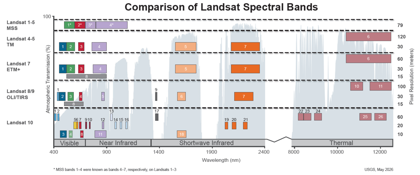
This image shows the bandpass wavelengths for the Landsat 1-9 sensors. *Landsat MSS = the numbers shown are for Landsat 4 and Landsat 5; Landsat 1-3 band numbers are 4, 5, 6 and 7.
Landsat 9 Data Products
Data acquired by Landsat 9 is processed into the Landsat Collection 2 inventory structure in the Worldwide Reference System-2 (WRS-2) path/row system, with swath overlap (or sidelap) varying from 7 percent at the Equator to a maximum of approximately 85 percent at extreme latitudes.
Landsat 9 collects as many as 750 scenes per day, and with Landsat 8, the two satellites add nearly 1,500 new scenes a day to the USGS Landsat archive. Landsat 9 increases the volume of the USGS archive by imaging all global landmasses and nearshore coastal regions, including islands at solar elevation angles greater than 5 degrees that were not always routinely collected prior to Landsat 8.
All Landsat 9 data and products are available for download through the USGS Earth Resources Observation and Science (EROS) Center at no charge.
Papers about Landsat 9's Pre-launch, Commissioning, and Early On-Orbit Imaging Performance Published in Science Journal
A new Remote Sensing Special Issue contains information on the calibration and validation activities performed on Landsat 9 instruments to ensure the gold standard of geometric, radiometric, spatial, and spectral resolutions are upheld for delivering the expected data quality. Topics in the special issue include pre-launch characterization, testing, commissioning, and early on-orbit performance for the OLI and TIRS instrument and Landsat 9 spacecraft. Visit the Remote Sensing webpage to access the papers in this issue.
Cape Cod, the hook-shaped peninsula in the state of Massachusetts, is a popular summertime destination and is easily visible in satellite imagery.
In this Landsat 9 image, the urban sprawl of Providence, Rhode Island is also displayed, along with Block Island south of the mainland, and Martha's Vineyard and Nantucket south of the Cape.
The Apostle Islands National Lakeshore encompasses 69,372 acres, of which 27,323 acres are submerged lands in Lake Superior. This unique collection of islands became a designated National Lakeshore on September 26, 1970. There are no roads or vehicle access to any of the 21 islands within the National Lakeshore.
The Apostle Islands National Lakeshore encompasses 69,372 acres, of which 27,323 acres are submerged lands in Lake Superior. This unique collection of islands became a designated National Lakeshore on September 26, 1970. There are no roads or vehicle access to any of the 21 islands within the National Lakeshore.
Found along the Pacific Ring of Fire, Russia’s Shiveluch Volcano began erupting on April 11, 2023. Huge ash clouds spewed from the main crater blanketing over 40,000 square miles (108,000 square kilometers). The tiny village of Klyuchi, about 30 mi (50 km) from the volcano, plunged into darkness.
Found along the Pacific Ring of Fire, Russia’s Shiveluch Volcano began erupting on April 11, 2023. Huge ash clouds spewed from the main crater blanketing over 40,000 square miles (108,000 square kilometers). The tiny village of Klyuchi, about 30 mi (50 km) from the volcano, plunged into darkness.
Landsat 9 image showing Washington D.C. on April 9, 2023. The image is shown using the Red, Green and Blue bands (Bands 4,3,2), combining these three bands produces a natural color view of the area. The image was then sharpened using the panchromatic band (Band 8) which has a higher resolution than the other bands (15 meters compared to 30 meters).
Landsat 9 image showing Washington D.C. on April 9, 2023. The image is shown using the Red, Green and Blue bands (Bands 4,3,2), combining these three bands produces a natural color view of the area. The image was then sharpened using the panchromatic band (Band 8) which has a higher resolution than the other bands (15 meters compared to 30 meters).
Landsat 9 image showing Washington D.C. on April 9, 2023. The image is shown using the Red, Green and Blue bands (Bands 4,3,2), combining these three bands produces a natural color view of the area. The image was then sharpened using the panchromatic band (Band 8) which has a higher resolution than the other bands (15 meters compared to 30 meters).
Landsat 9 image showing Washington D.C. on April 9, 2023. The image is shown using the Red, Green and Blue bands (Bands 4,3,2), combining these three bands produces a natural color view of the area. The image was then sharpened using the panchromatic band (Band 8) which has a higher resolution than the other bands (15 meters compared to 30 meters).
The Richat Structure, also known as the Eye of the Sahara, is a prominent circular geological formation in the Sahara Desert. The formation stretches across a 40 km-wide region in Mauritania in Northwest Africa.
This mosaic of the Richat Structure and surrounding area was creating using four natural color Landsat 9 images (Bands 4,3,2):
Rare spotting! Dueling volcanoes captured by Landsat 9 satellite. Mauna Loa's 11.3-mile-long lava flow illuminates the plume of ash in the atmosphere above. The small red spot in the lower right is Kilauea—it began erupting nine days ago. USGS Volcanoes says a dual eruption has not occurred in Hawaii since 1984, making this a rare event.
Rare spotting! Dueling volcanoes captured by Landsat 9 satellite. Mauna Loa's 11.3-mile-long lava flow illuminates the plume of ash in the atmosphere above. The small red spot in the lower right is Kilauea—it began erupting nine days ago. USGS Volcanoes says a dual eruption has not occurred in Hawaii since 1984, making this a rare event.
Landsat 9 Captures Hurricane Ian Aftermath (Sanibel Island)
Landsat 9 captured this image of the aftermath of Hurricane Ian in southwestern Florida on the morning of October 6, 2022. Sanibel Island is shown in the center, with breaches in the Sanibel Causeway that connects the island with the mainland. (White clouds also appear in this image.)
Landsat 9 captured this image of the aftermath of Hurricane Ian in southwestern Florida on the morning of October 6, 2022. Sanibel Island is shown in the center, with breaches in the Sanibel Causeway that connects the island with the mainland. (White clouds also appear in this image.)
Landsat 9 Captures Hurricane Ian Aftermath (New Smyrna Beach, FL)
Landsat 9 captured this image of the aftermath of Hurricane Ian in eastern Florida on the morning of October 6, 2022. It shows the coast and New Smyrna Beach, which experienced extensive flooding.
Landsat 9 captured this image of the aftermath of Hurricane Ian in eastern Florida on the morning of October 6, 2022. It shows the coast and New Smyrna Beach, which experienced extensive flooding.
Landsat 9 image of Hurricane Ian as the eye of the storm passed north of Cuba on the morning of Tuesday, September 27, 2022. The image has the island boundary overlaid on it. Image credit: USGS EROS
Landsat 9 image of Hurricane Ian as the eye of the storm passed north of Cuba on the morning of Tuesday, September 27, 2022. The image has the island boundary overlaid on it. Image credit: USGS EROS
The Aorounga Crater located in Chad, Africa is a large impact crater that appears as a circular depression surrounded by a raised rim, as seen in this Landsat 9 image. The crater is surrounded by a vast expanse of desert and is known for its unique rock ridges, known as yardangs.
The Aorounga Crater located in Chad, Africa is a large impact crater that appears as a circular depression surrounded by a raised rim, as seen in this Landsat 9 image. The crater is surrounded by a vast expanse of desert and is known for its unique rock ridges, known as yardangs.
The Aorounga Crater located in Chad, Africa is a large impact crater that appears as a circular depression surrounded by a raised rim, as seen in this Landsat 9 image. The crater is surrounded by a vast expanse of desert and is known for its unique rock ridges, known as yardangs.
The Aorounga Crater located in Chad, Africa is a large impact crater that appears as a circular depression surrounded by a raised rim, as seen in this Landsat 9 image. The crater is surrounded by a vast expanse of desert and is known for its unique rock ridges, known as yardangs.
Landsat 9 Image of Kangerdlugssuaq Glacier, Greenland
Named after a Greenlandic word meaning “large fjord,” Kangerdlugssuaq Glacier is one of the largest tidewater outlet glaciers in Greenland. It flows from the fjord of the same name, the second largest found on the east side of the island. This false color Landsat 9 image was acquired July 29, 2022, using Bands 5|4|3.
Named after a Greenlandic word meaning “large fjord,” Kangerdlugssuaq Glacier is one of the largest tidewater outlet glaciers in Greenland. It flows from the fjord of the same name, the second largest found on the east side of the island. This false color Landsat 9 image was acquired July 29, 2022, using Bands 5|4|3.
This Landsat 9 image, showing the Dallas - Fort Worth area of Texas, was acquired on July 15, 2022. This false-color image vegetated land in shades of red, whereas grays and whites indicate urban or rocky surfaces.
This Landsat 9 image, showing the Dallas - Fort Worth area of Texas, was acquired on July 15, 2022. This false-color image vegetated land in shades of red, whereas grays and whites indicate urban or rocky surfaces.
Landsat 9 image over Svalbard, Norway. Acquired on July 8, 2022, Path 26 Row 240. For more information on Landsat data, visit the Landsat Mission Website.
Landsat 9 image over Svalbard, Norway. Acquired on July 8, 2022, Path 26 Row 240. For more information on Landsat data, visit the Landsat Mission Website.
Landsat 9 Image of Washburn Fire, Yosemite National Park - July 7, 2022
The Washburn Fire started July 7, 2022 in the southern part of Yosemite National Park. Landsats 8 and 9 both captured imagery of it a day later. The Landsat 9 image uses shortwave infrared and near-infrared bands to show the active burning.
The Washburn Fire started July 7, 2022 in the southern part of Yosemite National Park. Landsats 8 and 9 both captured imagery of it a day later. The Landsat 9 image uses shortwave infrared and near-infrared bands to show the active burning.
In Alaska, the Sagavanirktok River flows North to empty in Beaufort Sea near Prudhoe Bay. Landsat 9 captured this false color image on July 1, 2022, using Bands 6|5|4.
In Alaska, the Sagavanirktok River flows North to empty in Beaufort Sea near Prudhoe Bay. Landsat 9 captured this false color image on July 1, 2022, using Bands 6|5|4.
All Landsat 9 Collection 2 Operational Land Imager (OLI) and Thermal Infrared Sensor (TIRS) data will be reprocessed at the end of 2022 to take advantage of calibration updates identified during the first year of operation.
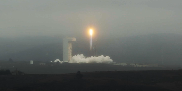
Santa Barbara County, CA, became a hub of Landsat activity in the last week of September 2021. That’s the week Landsat 9 launched into orbit on board...
USGS EROS, Landsat 9 Ground System Ready for Launch
The launch of Landsat 9 in late September of 2021 represents a major milestone for a five-decade partnership between NASA and the USGS that continues...
Landsat 9: Dress Rehearsal of Launch Day Completed
Putting the launch team, rocket and California pad to the test, United Launch Alliance (ULA) spent Friday rehearsing the countdown to launch an Atlas...
Landsat 9 Ground System Meets Design Criteria to Move Forward
Tim Rykowski has a history of reviewing satellite ground systems. NASA’s Space Network Systems Manager, Rykowski figures he’s probably sat in on a few...
Cape Cod, the hook-shaped peninsula in the state of Massachusetts, is a popular summertime destination and is easily visible in satellite imagery.
In this Landsat 9 image, the urban sprawl of Providence, Rhode Island is also displayed, along with Block Island south of the mainland, and Martha's Vineyard and Nantucket south of the Cape.
The Apostle Islands National Lakeshore encompasses 69,372 acres, of which 27,323 acres are submerged lands in Lake Superior. This unique collection of islands became a designated National Lakeshore on September 26, 1970. There are no roads or vehicle access to any of the 21 islands within the National Lakeshore.
The Apostle Islands National Lakeshore encompasses 69,372 acres, of which 27,323 acres are submerged lands in Lake Superior. This unique collection of islands became a designated National Lakeshore on September 26, 1970. There are no roads or vehicle access to any of the 21 islands within the National Lakeshore.
Found along the Pacific Ring of Fire, Russia’s Shiveluch Volcano began erupting on April 11, 2023. Huge ash clouds spewed from the main crater blanketing over 40,000 square miles (108,000 square kilometers). The tiny village of Klyuchi, about 30 mi (50 km) from the volcano, plunged into darkness.
Found along the Pacific Ring of Fire, Russia’s Shiveluch Volcano began erupting on April 11, 2023. Huge ash clouds spewed from the main crater blanketing over 40,000 square miles (108,000 square kilometers). The tiny village of Klyuchi, about 30 mi (50 km) from the volcano, plunged into darkness.
Landsat 9 image showing Washington D.C. on April 9, 2023. The image is shown using the Red, Green and Blue bands (Bands 4,3,2), combining these three bands produces a natural color view of the area. The image was then sharpened using the panchromatic band (Band 8) which has a higher resolution than the other bands (15 meters compared to 30 meters).
Landsat 9 image showing Washington D.C. on April 9, 2023. The image is shown using the Red, Green and Blue bands (Bands 4,3,2), combining these three bands produces a natural color view of the area. The image was then sharpened using the panchromatic band (Band 8) which has a higher resolution than the other bands (15 meters compared to 30 meters).
Landsat 9 image showing Washington D.C. on April 9, 2023. The image is shown using the Red, Green and Blue bands (Bands 4,3,2), combining these three bands produces a natural color view of the area. The image was then sharpened using the panchromatic band (Band 8) which has a higher resolution than the other bands (15 meters compared to 30 meters).
Landsat 9 image showing Washington D.C. on April 9, 2023. The image is shown using the Red, Green and Blue bands (Bands 4,3,2), combining these three bands produces a natural color view of the area. The image was then sharpened using the panchromatic band (Band 8) which has a higher resolution than the other bands (15 meters compared to 30 meters).
The Richat Structure, also known as the Eye of the Sahara, is a prominent circular geological formation in the Sahara Desert. The formation stretches across a 40 km-wide region in Mauritania in Northwest Africa.
This mosaic of the Richat Structure and surrounding area was creating using four natural color Landsat 9 images (Bands 4,3,2):
Rare spotting! Dueling volcanoes captured by Landsat 9 satellite. Mauna Loa's 11.3-mile-long lava flow illuminates the plume of ash in the atmosphere above. The small red spot in the lower right is Kilauea—it began erupting nine days ago. USGS Volcanoes says a dual eruption has not occurred in Hawaii since 1984, making this a rare event.
Rare spotting! Dueling volcanoes captured by Landsat 9 satellite. Mauna Loa's 11.3-mile-long lava flow illuminates the plume of ash in the atmosphere above. The small red spot in the lower right is Kilauea—it began erupting nine days ago. USGS Volcanoes says a dual eruption has not occurred in Hawaii since 1984, making this a rare event.
Landsat 9 Captures Hurricane Ian Aftermath (Sanibel Island)
Landsat 9 captured this image of the aftermath of Hurricane Ian in southwestern Florida on the morning of October 6, 2022. Sanibel Island is shown in the center, with breaches in the Sanibel Causeway that connects the island with the mainland. (White clouds also appear in this image.)
Landsat 9 captured this image of the aftermath of Hurricane Ian in southwestern Florida on the morning of October 6, 2022. Sanibel Island is shown in the center, with breaches in the Sanibel Causeway that connects the island with the mainland. (White clouds also appear in this image.)
Landsat 9 Captures Hurricane Ian Aftermath (New Smyrna Beach, FL)
Landsat 9 captured this image of the aftermath of Hurricane Ian in eastern Florida on the morning of October 6, 2022. It shows the coast and New Smyrna Beach, which experienced extensive flooding.
Landsat 9 captured this image of the aftermath of Hurricane Ian in eastern Florida on the morning of October 6, 2022. It shows the coast and New Smyrna Beach, which experienced extensive flooding.
Landsat 9 image of Hurricane Ian as the eye of the storm passed north of Cuba on the morning of Tuesday, September 27, 2022. The image has the island boundary overlaid on it. Image credit: USGS EROS
Landsat 9 image of Hurricane Ian as the eye of the storm passed north of Cuba on the morning of Tuesday, September 27, 2022. The image has the island boundary overlaid on it. Image credit: USGS EROS
The Aorounga Crater located in Chad, Africa is a large impact crater that appears as a circular depression surrounded by a raised rim, as seen in this Landsat 9 image. The crater is surrounded by a vast expanse of desert and is known for its unique rock ridges, known as yardangs.
The Aorounga Crater located in Chad, Africa is a large impact crater that appears as a circular depression surrounded by a raised rim, as seen in this Landsat 9 image. The crater is surrounded by a vast expanse of desert and is known for its unique rock ridges, known as yardangs.
The Aorounga Crater located in Chad, Africa is a large impact crater that appears as a circular depression surrounded by a raised rim, as seen in this Landsat 9 image. The crater is surrounded by a vast expanse of desert and is known for its unique rock ridges, known as yardangs.
The Aorounga Crater located in Chad, Africa is a large impact crater that appears as a circular depression surrounded by a raised rim, as seen in this Landsat 9 image. The crater is surrounded by a vast expanse of desert and is known for its unique rock ridges, known as yardangs.
Landsat 9 Image of Kangerdlugssuaq Glacier, Greenland
Named after a Greenlandic word meaning “large fjord,” Kangerdlugssuaq Glacier is one of the largest tidewater outlet glaciers in Greenland. It flows from the fjord of the same name, the second largest found on the east side of the island. This false color Landsat 9 image was acquired July 29, 2022, using Bands 5|4|3.
Named after a Greenlandic word meaning “large fjord,” Kangerdlugssuaq Glacier is one of the largest tidewater outlet glaciers in Greenland. It flows from the fjord of the same name, the second largest found on the east side of the island. This false color Landsat 9 image was acquired July 29, 2022, using Bands 5|4|3.
This Landsat 9 image, showing the Dallas - Fort Worth area of Texas, was acquired on July 15, 2022. This false-color image vegetated land in shades of red, whereas grays and whites indicate urban or rocky surfaces.
This Landsat 9 image, showing the Dallas - Fort Worth area of Texas, was acquired on July 15, 2022. This false-color image vegetated land in shades of red, whereas grays and whites indicate urban or rocky surfaces.
Landsat 9 image over Svalbard, Norway. Acquired on July 8, 2022, Path 26 Row 240. For more information on Landsat data, visit the Landsat Mission Website.
Landsat 9 image over Svalbard, Norway. Acquired on July 8, 2022, Path 26 Row 240. For more information on Landsat data, visit the Landsat Mission Website.
Landsat 9 Image of Washburn Fire, Yosemite National Park - July 7, 2022
The Washburn Fire started July 7, 2022 in the southern part of Yosemite National Park. Landsats 8 and 9 both captured imagery of it a day later. The Landsat 9 image uses shortwave infrared and near-infrared bands to show the active burning.
The Washburn Fire started July 7, 2022 in the southern part of Yosemite National Park. Landsats 8 and 9 both captured imagery of it a day later. The Landsat 9 image uses shortwave infrared and near-infrared bands to show the active burning.
Landsat 9 Image of Washburn Fire, Yosemite National Park - July 7, 2022
The Washburn Fire started July 7, 2022 in the southern part of Yosemite National Park. Landsats 8 and 9 both captured imagery of it a day later. The Landsat 9 image uses shortwave infrared and near-infrared bands to show the active burning.
The Washburn Fire started July 7, 2022 in the southern part of Yosemite National Park. Landsats 8 and 9 both captured imagery of it a day later. The Landsat 9 image uses shortwave infrared and near-infrared bands to show the active burning.
In Alaska, the Sagavanirktok River flows North to empty in Beaufort Sea near Prudhoe Bay. Landsat 9 captured this false color image on July 1, 2022, using Bands 6|5|4.
In Alaska, the Sagavanirktok River flows North to empty in Beaufort Sea near Prudhoe Bay. Landsat 9 captured this false color image on July 1, 2022, using Bands 6|5|4.
All Landsat 9 Collection 2 Operational Land Imager (OLI) and Thermal Infrared Sensor (TIRS) data will be reprocessed at the end of 2022 to take advantage of calibration updates identified during the first year of operation.
Santa Barbara County, CA, became a hub of Landsat activity in the last week of September 2021. That’s the week Landsat 9 launched into orbit on board...
USGS EROS, Landsat 9 Ground System Ready for Launch
The launch of Landsat 9 in late September of 2021 represents a major milestone for a five-decade partnership between NASA and the USGS that continues...
Landsat 9: Dress Rehearsal of Launch Day Completed
Putting the launch team, rocket and California pad to the test, United Launch Alliance (ULA) spent Friday rehearsing the countdown to launch an Atlas...
Landsat 9 Ground System Meets Design Criteria to Move Forward
Tim Rykowski has a history of reviewing satellite ground systems. NASA’s Space Network Systems Manager, Rykowski figures he’s probably sat in on a few...