
The EROS, or Earth Resources Observation Satellite, Program was formally established by Secretarial Order in 1967. Under the EROS Program, Chuck became the Associate Program Manager. In this position, Charles J. Robinove participated in international remote sensing workshops, facilitated remote sensing research, and coordinated program development.
Images
Core Science Systems images.
Filter Total Items: 667

Charles J. Robinove
The EROS, or Earth Resources Observation Satellite, Program was formally established by Secretarial Order in 1967. Under the EROS Program, Chuck became the Associate Program Manager. In this position, Charles J. Robinove participated in international remote sensing workshops, facilitated remote sensing research, and coordinated program development.

EROS 50th Anniversary Graphic Animated
First came the notion of viewing the Earth’s land surfaces regularly by satellite in the 1960s. Then came the launch of Landsat 1 in 1972, with scientists and governments delighting in the revelations.
First came the notion of viewing the Earth’s land surfaces regularly by satellite in the 1960s. Then came the launch of Landsat 1 in 1972, with scientists and governments delighting in the revelations.

Canada Wildfire
Smoke filled the skies over western Canada and even much of the United States in May 2023. The source was several wildfires in Alberta and British Columbia.
Near the end of May, rain and cooler temperatures finally brought some relief for the out-of-control fires.
Smoke filled the skies over western Canada and even much of the United States in May 2023. The source was several wildfires in Alberta and British Columbia.
Near the end of May, rain and cooler temperatures finally brought some relief for the out-of-control fires.

Canada Wildfires
Smoke filled the skies over western Canada and even much of the United States in May 2023. The source was several wildfires in Alberta and British Columbia.
Landsat 8 captured this image on May 26, 2023.
Smoke filled the skies over western Canada and even much of the United States in May 2023. The source was several wildfires in Alberta and British Columbia.
Landsat 8 captured this image on May 26, 2023.

Topobathymetric digital elevation model of the confluence of the Potomac and Shenandoah Rivers
Topobathymetric digital elevation model of the confluence of the Potomac and Shenandoah RiversTopobathymetric digital elevation model of the confluence of the Potomac and Shenandoah Rivers at Harper’s Ferry, West Virginia.

Map of the Potomac River topobathymetric lidar survey area.
Map of the Potomac River topobathymetric lidar survey area.Map of the Potomac River topobathymetric lidar survey area in Virginia, Maryland, and West Virginia.
Map of the Potomac River topobathymetric lidar survey area.
Map of the Potomac River topobathymetric lidar survey area.Map of the Potomac River topobathymetric lidar survey area in Virginia, Maryland, and West Virginia.
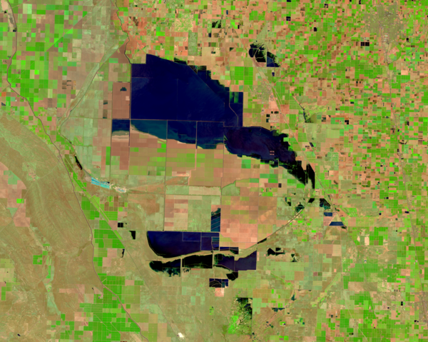
Tulare Lake Refills in 2023
The Tulare Lake Basin lies in the southern portion of the San Joaquin Valley. It once stretched up to 100 miles long and 30 miles wide. Referred to as the largest freshwater lake west of the Mississippi River, Tulare Lake appeared naturally as spring rains and snowmelt from the nearby Sierra Nevada mountain range flowed down and filled the basin.
The Tulare Lake Basin lies in the southern portion of the San Joaquin Valley. It once stretched up to 100 miles long and 30 miles wide. Referred to as the largest freshwater lake west of the Mississippi River, Tulare Lake appeared naturally as spring rains and snowmelt from the nearby Sierra Nevada mountain range flowed down and filled the basin.

USGS EROS Tour
Individuals, families, classrooms, and other organizations are all welcome to visit EROS. A free one-hour walking tour brings remote sensing science to life with satellite models, large displays, and knowledgeable staff.
Individuals, families, classrooms, and other organizations are all welcome to visit EROS. A free one-hour walking tour brings remote sensing science to life with satellite models, large displays, and knowledgeable staff.

Collection 2 Landsat 9 Dynamic Surface Water Extent Example
Collection 2 Landsat 9 Dynamic Surface Water Extent ExampleImage of Collection 2 Landsat 9 Level-3 DSWE near the North Carolina shoreline captured November 14th, 2021. This image displays a portion of ARD tile H021V010.
Collection 2 Landsat 9 Dynamic Surface Water Extent Example
Collection 2 Landsat 9 Dynamic Surface Water Extent ExampleImage of Collection 2 Landsat 9 Level-3 DSWE near the North Carolina shoreline captured November 14th, 2021. This image displays a portion of ARD tile H021V010.

Czech Scientists Visit USGS EROS in 2023
From left to right, with badges: Marcine Hyser, Jesslyn Brown and Josh Picotte welcome visitors from the Czech Republic (left to right with no badges) Monika Blahova, Lucie Kudlackova and Marketa Podebradska. Photo by Deb Kindelspire.
From left to right, with badges: Marcine Hyser, Jesslyn Brown and Josh Picotte welcome visitors from the Czech Republic (left to right with no badges) Monika Blahova, Lucie Kudlackova and Marketa Podebradska. Photo by Deb Kindelspire.

3DEP Quality Data by Collection Year
3DEP Quality Data by Collection Year
Age of 3DEP
Dark Green: Planned FY23
Light Green - Red: 2022 - 2004
Gray: Data Contribution Pending
3DEP Quality Data by Collection Year
Age of 3DEP
Dark Green: Planned FY23
Light Green - Red: 2022 - 2004
Gray: Data Contribution Pending

Tulare Basin Refills IOW thumbnail
This is a thumbnail or screenshot for the new Image of the Week of Tulare Basin.
This is a thumbnail or screenshot for the new Image of the Week of Tulare Basin.

Klamath River
The Yurok Tribe’s Condor Aviation and Fisheries Department collect LiDAR data on the Klamath River in Northern California.
The Yurok Tribe’s Condor Aviation and Fisheries Department collect LiDAR data on the Klamath River in Northern California.

Lidar Point Cloud of Devil's Tower National Monument
Lidar Point Cloud of Devil's Tower National MonumentLidar Point Cloud of Devil's Tower National Monument in Wyoming with a brown to gray color ramp symbology with brown representing low elevation, and gray representing high elevation
Lidar Point Cloud of Devil's Tower National Monument
Lidar Point Cloud of Devil's Tower National MonumentLidar Point Cloud of Devil's Tower National Monument in Wyoming with a brown to gray color ramp symbology with brown representing low elevation, and gray representing high elevation

Lidar point cloud image of the Hoover Dam in Nevada.
Lidar point cloud image of the Hoover Dam in Nevada.Lidar point cloud image taken above of the Hoover Dam in Nevada. Image was created by Jason Stoker.
Lidar point cloud image of the Hoover Dam in Nevada.
Lidar point cloud image of the Hoover Dam in Nevada.Lidar point cloud image taken above of the Hoover Dam in Nevada. Image was created by Jason Stoker.

Lidar Point Cloud of Central Park in New York City
Lidar Point Cloud of Central Park in New York CityLidar Point Cloud of Central Park in New York City shaded by RGB values from orthophotos
Lidar Point Cloud of Central Park in New York City
Lidar Point Cloud of Central Park in New York CityLidar Point Cloud of Central Park in New York City shaded by RGB values from orthophotos

Recipient of the Pecora Individual Award: Jack A. Kaye, PhD.
Recipient of the Pecora Individual Award: Jack A. Kaye, PhD.Recipient of the 2024 Pecora Individual Award Jack A. Kaye, PhD. This photo was added to Drupal for use in related feature story.
Recipient of the Pecora Individual Award: Jack A. Kaye, PhD.
Recipient of the Pecora Individual Award: Jack A. Kaye, PhD.Recipient of the 2024 Pecora Individual Award Jack A. Kaye, PhD. This photo was added to Drupal for use in related feature story.

BDWA Title Card
This is the title card for the "Bulk Download Web Application" video. This is a tool that allows for bulk downloads of scenes and data from EarthExplorer.
This is the title card for the "Bulk Download Web Application" video. This is a tool that allows for bulk downloads of scenes and data from EarthExplorer.

Landsat 9 Image of Washington D.C.
Landsat 9 image showing Washington D.C. on April 9, 2023. The image is shown using the Red, Green and Blue bands (Bands 4,3,2), combining these three bands produces a natural color view of the area. The image was then sharpened using the panchromatic band (Band 8) which has a higher resolution than the other bands (15 meters compared to 30 meters).
Landsat 9 image showing Washington D.C. on April 9, 2023. The image is shown using the Red, Green and Blue bands (Bands 4,3,2), combining these three bands produces a natural color view of the area. The image was then sharpened using the panchromatic band (Band 8) which has a higher resolution than the other bands (15 meters compared to 30 meters).