
This image of Lake Tahoe, California displays the landscape's vegetation properties in shades of red. This image was created using Bands 5,4, and 3 from data acquired by Landsat 8 on February 13, 2022.
Images
Core Science Systems images.
Filter Total Items: 667

Landsat 8 Color Infrared Image of Lake Tahoe
This image of Lake Tahoe, California displays the landscape's vegetation properties in shades of red. This image was created using Bands 5,4, and 3 from data acquired by Landsat 8 on February 13, 2022.

Fractional Snow Cover Area of Lake Tahoe
The Landsat Fractional Snow Covered Area (fSCA) product provides per-pixel fractional snow cover maps that indicate the percentage of a pixel covered by snow.
The Landsat Fractional Snow Covered Area (fSCA) product provides per-pixel fractional snow cover maps that indicate the percentage of a pixel covered by snow.

Thumbnail for IOW Brunt Ice Shelf 2023
This is the thumbnail image for an Image of the Week about a 2023 update of the Brunt Ice Shelf event.
This is the thumbnail image for an Image of the Week about a 2023 update of the Brunt Ice Shelf event.

Children play with interactive Landsat satellite imagery floor puzzle of the Navajo Nation.
Children play with interactive Landsat satellite imagery floor puzzle of the Navajo Nation.Children play with 12’x12′ interactive floor puzzle of the Navajo Nation, created from Landsat satellite imagery by Earth observation education partner, AmericaView during the Nihima Nahasdzáán−The Art of Mother Earth Gallery Event.
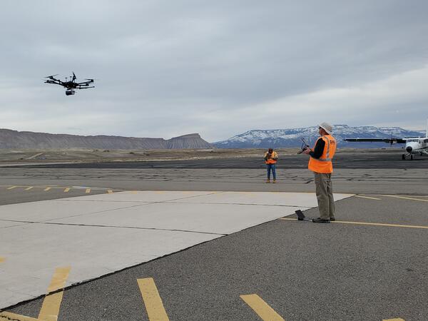
Drone being flown for instrument testing
Gamma Ray Spectrometer testing at DOE Environmental Radiation Calibration Facility located on Grand Junction Airport.
Gamma Ray Spectrometer testing at DOE Environmental Radiation Calibration Facility located on Grand Junction Airport.

Lidar point cloud image of downtown Chicago, Illinois.
Lidar point cloud image of downtown Chicago, Illinois.Airborne lidar point cloud image of downtown Chicago, Illinois skyline. Image created by Jason Stoker.
Lidar point cloud image of downtown Chicago, Illinois.
Lidar point cloud image of downtown Chicago, Illinois.Airborne lidar point cloud image of downtown Chicago, Illinois skyline. Image created by Jason Stoker.

Earthshots Tournament 2023 Square
32 satellite images are vying for the coveted title of Earthshot. See the images and download your bracket here:
https://geonarrative.usgs.gov/earthshots-tournament/
32 satellite images are vying for the coveted title of Earthshot. See the images and download your bracket here:
https://geonarrative.usgs.gov/earthshots-tournament/

NDVI map of the San Joaquin Valley Region, March 13, 2023
NDVI map of the San Joaquin Valley Region, March 13, 2023A Landsat Surface Reflectance (SR) Normalized Difference Index (NDVI) map of the San Joaquin Valley region of California on March 13, 2023.
NDVI map of the San Joaquin Valley Region, March 13, 2023
NDVI map of the San Joaquin Valley Region, March 13, 2023A Landsat Surface Reflectance (SR) Normalized Difference Index (NDVI) map of the San Joaquin Valley region of California on March 13, 2023.

Landsat Dashboard Archive Image
Use the filters on the right and the map tools to narrow down an area of interest with 10,000 products or less. After filtering, select the download icon in the bottom right corner.
Use the filters on the right and the map tools to narrow down an area of interest with 10,000 products or less. After filtering, select the download icon in the bottom right corner.

Image of the Week (IOW) Cheyenne Bottoms Dries Out thumbnail
Image of the Week (IOW) Cheyenne Bottoms Dries Out thumbnailImage of the Week (IOW) Cheyenne Bottoms Dries Out thumbnail. Image of the Week highlights satellite and other remote sensing imagery from around the world.
Image of the Week (IOW) Cheyenne Bottoms Dries Out thumbnail
Image of the Week (IOW) Cheyenne Bottoms Dries Out thumbnailImage of the Week (IOW) Cheyenne Bottoms Dries Out thumbnail. Image of the Week highlights satellite and other remote sensing imagery from around the world.

ScienceBase - manage edit
screenshot showing option to edit ScienceBase item through the edit form. "Edit Item" is circled in the screenshot.
screenshot showing option to edit ScienceBase item through the edit form. "Edit Item" is circled in the screenshot.

Profile view of an airborne lidar point cloud of a forest
Profile view of an airborne lidar point cloud of a forestProfile view of an airborne lidar point cloud of a forest located in Yosemite National Park, California. The points are colored based on the y-coordinate location, so that closer trees are shaded red, and trees further away are in blue.

found_fgdc_metadata
screenshot showing dialog that asks if user wants to populate ScienceBase item fields using content from metadata file
screenshot showing dialog that asks if user wants to populate ScienceBase item fields using content from metadata file

add_child_item
Screenshot showing option to add child item to landing page in ScienceBase. There is a red arrow indicating the selection.
Screenshot showing option to add child item to landing page in ScienceBase. There is a red arrow indicating the selection.

Landsat Archive Dashboard Step 1
Use the filters on the right and the map tools to narrow down an area of interest with 10,000 products or less. After filtering, select the download icon in the bottom right corner.
Use the filters on the right and the map tools to narrow down an area of interest with 10,000 products or less. After filtering, select the download icon in the bottom right corner.

Eyes on Earth Podcast Covers - Wide
This is a new image for the Eyes on Earth webpage. To listen to the podcast, visit here: https://www.usgs.gov/centers/eros/eyes-earth
This is a new image for the Eyes on Earth webpage. To listen to the podcast, visit here: https://www.usgs.gov/centers/eros/eyes-earth

RCMAP Factsheet
A New RCMAP Factsheet is available. View it here: https://pubs.er.usgs.gov/publication/fs20233004
A New RCMAP Factsheet is available. View it here: https://pubs.er.usgs.gov/publication/fs20233004

Eyes on Earth Podcast Covers - Wide
This is a new image for the Eyes on Earth webpage. To listen to the podcast, visit here: https://www.usgs.gov/centers/eros/eyes-earth
This is a new image for the Eyes on Earth webpage. To listen to the podcast, visit here: https://www.usgs.gov/centers/eros/eyes-earth

Valentine, Nebraska
Be mine, Valentine.

Increases in U.S. Analysis Ready Data Tiles with Collection 2
Increases in U.S. Analysis Ready Data Tiles with Collection 2This graphic shows additional tiles available for Collection 2 U.S. Analysis Ready Data (ARD) when compared to Collection 1 U.S. ARD for the same period (1982-2021).
Increases in U.S. Analysis Ready Data Tiles with Collection 2
Increases in U.S. Analysis Ready Data Tiles with Collection 2This graphic shows additional tiles available for Collection 2 U.S. Analysis Ready Data (ARD) when compared to Collection 1 U.S. ARD for the same period (1982-2021).