



This Landsat 9 image from June 13, 2024, shows the Beaufort Sea near Prudhoe Bay, Alaska, using the Shortwave Infrared, Near Infrared, and Reds (Band 6|5|4), and sharpened with the with Panchromatic band (Band 8). The cyan tones highlight sea ice and melt ponds, while the red areas represent land and vegetation.
Images
Core Science Systems images.
Filter Total Items: 685

Landsat 9 View of Beaufort Sea Melt Ponds
This Landsat 9 image from June 13, 2024, shows the Beaufort Sea near Prudhoe Bay, Alaska, using the Shortwave Infrared, Near Infrared, and Reds (Band 6|5|4), and sharpened with the with Panchromatic band (Band 8). The cyan tones highlight sea ice and melt ponds, while the red areas represent land and vegetation.

The Legacy of Landsat 7 — Citations in Policy & Publications
The Legacy of Landsat 7 — Citations in Policy & PublicationsFor 25 years, the Landsat 7 satellite acquired millions of images of Earth that supported studies of how land is used and how it has changed across urban, agriculture, forest, snow and ice-covered areas around the globe, as well as natural and manmade disasters.
The Legacy of Landsat 7 — Citations in Policy & Publications
The Legacy of Landsat 7 — Citations in Policy & PublicationsFor 25 years, the Landsat 7 satellite acquired millions of images of Earth that supported studies of how land is used and how it has changed across urban, agriculture, forest, snow and ice-covered areas around the globe, as well as natural and manmade disasters.

Norwegian Ambassador visit to USGS EROS
Group photo during the Norwegian Ambassador's visit to EROS.
Group photo during the Norwegian Ambassador's visit to EROS.

Inaugural U.S.-Germany Space Dialogue Space Dialogue
Inaugural U.S.-Germany Space Dialogue Space DialogueImage from the inaugural U.S.-Germany Space Dialogue Space Dialogue in Berlin on June 4, 2024.
Inaugural U.S.-Germany Space Dialogue Space Dialogue
Inaugural U.S.-Germany Space Dialogue Space DialogueImage from the inaugural U.S.-Germany Space Dialogue Space Dialogue in Berlin on June 4, 2024.

USGS and German Aerospace Center sign statement of intent for upcoming Landsat Next mission.
USGS and German Aerospace Center sign statement of intent for upcoming Landsat Next mission.The U.S. Geological Survey and German Aerospace Center (Deutsches Zentrum für Luft-und Raumfahrt or DLR sign statement for plans to continue partnership with the upcoming Landsat Next satellite mission.
USGS and German Aerospace Center sign statement of intent for upcoming Landsat Next mission.
USGS and German Aerospace Center sign statement of intent for upcoming Landsat Next mission.The U.S. Geological Survey and German Aerospace Center (Deutsches Zentrum für Luft-und Raumfahrt or DLR sign statement for plans to continue partnership with the upcoming Landsat Next satellite mission.

USGS and German Aerospace Center sign statement of intent for Landsat Next mission.
USGS and German Aerospace Center sign statement of intent for Landsat Next mission.USGS and German Aerospace Center sign statement of intent for upcoming Landsat Next mission.
(Left to Right): Head of the DLR Space Division Dr. Anke Pagels-Kerp and USGS Deputy Director-Operations Cindy Lodge.
USGS and German Aerospace Center sign statement of intent for Landsat Next mission.
USGS and German Aerospace Center sign statement of intent for Landsat Next mission.USGS and German Aerospace Center sign statement of intent for upcoming Landsat Next mission.
(Left to Right): Head of the DLR Space Division Dr. Anke Pagels-Kerp and USGS Deputy Director-Operations Cindy Lodge.

USGS Deputy Director-Operations Cindy Lodge with DLR’s German Remote Sensing Data Center (DFD) Director professor Stefan Dech.
USGS Deputy Director-Operations Cindy Lodge with DLR’s German Remote Sensing Data Center (DFD) Director professor Stefan Dech.USGS Deputy Director-Operations Cindy Lodge shown here with DLR’s German Remote Sensing Data Center (DFD) Director professor Stefan Dech at DLR’s Earth Observation Center in Oberpfaffenhofen finalizing the signatures on the statement of intent for the upcoming Landsat Next mission.
USGS Deputy Director-Operations Cindy Lodge with DLR’s German Remote Sensing Data Center (DFD) Director professor Stefan Dech.
USGS Deputy Director-Operations Cindy Lodge with DLR’s German Remote Sensing Data Center (DFD) Director professor Stefan Dech.USGS Deputy Director-Operations Cindy Lodge shown here with DLR’s German Remote Sensing Data Center (DFD) Director professor Stefan Dech at DLR’s Earth Observation Center in Oberpfaffenhofen finalizing the signatures on the statement of intent for the upcoming Landsat Next mission.

STATEMAP Partners
STATEMAP partners gather in Park City Utah during the 2024 annual meeting of the Association of American State Geologists.
STATEMAP partners gather in Park City Utah during the 2024 annual meeting of the Association of American State Geologists.
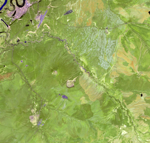
2024 Landsat Image of Batagaika Crater
Sometimes described as resembling a stingray or a tadpole, the Batagaika Crater is a widening chasm in Siberia and the world’s largest permafrost crater.
Sometimes described as resembling a stingray or a tadpole, the Batagaika Crater is a widening chasm in Siberia and the world’s largest permafrost crater.

Aerial View of NGP Spelled Out
Aerial photo of National Geospatial Program employees spelling out NGP taken from a Skydio X10 drone with the VT300-Z camera by Todd Burton
Aerial photo of National Geospatial Program employees spelling out NGP taken from a Skydio X10 drone with the VT300-Z camera by Todd Burton

MSL image of the Martian Surface on sol 4158
This image was taken of the Martian surface by the NASA MSL rover on sol 4158, showing an assortment of clasts.
This image was taken of the Martian surface by the NASA MSL rover on sol 4158, showing an assortment of clasts.

Landsat 8 Image of Tiwi Islands
This Landsat 8 images displays the Tiwi Islands.
The Tiwi Islands are part of the Northern Territory, Australia, north of Darwin in the Timor Sea. They are comprised of the islands of Melville and Bathurst, and nine smaller, uninhabited islands.
This Landsat 8 images displays the Tiwi Islands.
The Tiwi Islands are part of the Northern Territory, Australia, north of Darwin in the Timor Sea. They are comprised of the islands of Melville and Bathurst, and nine smaller, uninhabited islands.

Landsat 9 Image Captures Iceland Volcano Lava
In November 2023 the Svartsengi volcanic system awakened after almost 800 years with a series of earthquakes that opened large cracks in the on Iceland’s Reykjanes Peninsula. An eruption on December 18th spewed lava away from the nearby coastal town of Grindavik, but the January 14, 2024 eruption sent lava directly toward the town.
In November 2023 the Svartsengi volcanic system awakened after almost 800 years with a series of earthquakes that opened large cracks in the on Iceland’s Reykjanes Peninsula. An eruption on December 18th spewed lava away from the nearby coastal town of Grindavik, but the January 14, 2024 eruption sent lava directly toward the town.

NLB_764937797EDR_F1061524NCAM00277M_.jpeg
Image shows a poorly sorted collection of clasts, taken by the NASA Mars Curiosity rover on sol 4139.
Image shows a poorly sorted collection of clasts, taken by the NASA Mars Curiosity rover on sol 4139.

Fractional cover of Olifants River, Koekenaap, South Africa
Fractional cover of Olifants River, Koekenaap, South AfricaFractional cover of Olifants River, Koekenaap, South Africa, with 3-month intervals captured in 2020 processed by Digital Earth Africa with legend showing the RBG (Red-Blue-Green) breakdown. Image credit: Geoscience Australia
Fractional cover of Olifants River, Koekenaap, South Africa
Fractional cover of Olifants River, Koekenaap, South AfricaFractional cover of Olifants River, Koekenaap, South Africa, with 3-month intervals captured in 2020 processed by Digital Earth Africa with legend showing the RBG (Red-Blue-Green) breakdown. Image credit: Geoscience Australia

Ministry of Agriculture staff in Zambia mapping and analyzing crop production.
Ministry of Agriculture staff in Zambia mapping and analyzing crop production.Ministry of Agriculture staff in Zambia mapping and analyzing crop production. Photo credit: Geoscience Australia
Ministry of Agriculture staff in Zambia mapping and analyzing crop production.
Ministry of Agriculture staff in Zambia mapping and analyzing crop production.Ministry of Agriculture staff in Zambia mapping and analyzing crop production. Photo credit: Geoscience Australia

Field Survey on Irrigation Techniques in Mozambique
Field Survey on Irrigation Techniques in MozambiqueTimon Weitkamp and the team collecting field data on irrigation techniques in Mozambique. Photo credit: Geoscience Australia
Field Survey on Irrigation Techniques in Mozambique
Field Survey on Irrigation Techniques in MozambiqueTimon Weitkamp and the team collecting field data on irrigation techniques in Mozambique. Photo credit: Geoscience Australia

USGS and Australia agree to a partner on upcoming Landsat Next satellite mission with signing of statement.
USGS and Australia agree to a partner on upcoming Landsat Next satellite mission with signing of statement.The U.S. Geological Survey and Australia move toward a partnership as Australia announces plans to join upcoming Landsat Next satellite mission.
USGS and Australia agree to a partner on upcoming Landsat Next satellite mission with signing of statement.
USGS and Australia agree to a partner on upcoming Landsat Next satellite mission with signing of statement.The U.S. Geological Survey and Australia move toward a partnership as Australia announces plans to join upcoming Landsat Next satellite mission.

USGS and Australia agree to a partner on upcoming Landsat Next satellite mission.
USGS and Australia agree to a partner on upcoming Landsat Next satellite mission.The U.S. Geological Survey and Australia move toward a partnership as Australia announces plans to join upcoming Landsat Next satellite mission.
USGS and Australia agree to a partner on upcoming Landsat Next satellite mission.
USGS and Australia agree to a partner on upcoming Landsat Next satellite mission.The U.S. Geological Survey and Australia move toward a partnership as Australia announces plans to join upcoming Landsat Next satellite mission.

Pecora Award Winner Russell Congalton Is Congratulated by EROS Chief of Staff Tim Glynn at Geo Week
Pecora Award Winner Russell Congalton Is Congratulated by EROS Chief of Staff Tim Glynn at Geo WeekPecora Award Winner Russell Congalton is congratulated by EROS Chief of Staff Tim Glynn at Geo Week in Denver. Photo credit: Shado Congalton.
Pecora Award Winner Russell Congalton Is Congratulated by EROS Chief of Staff Tim Glynn at Geo Week
Pecora Award Winner Russell Congalton Is Congratulated by EROS Chief of Staff Tim Glynn at Geo WeekPecora Award Winner Russell Congalton is congratulated by EROS Chief of Staff Tim Glynn at Geo Week in Denver. Photo credit: Shado Congalton.

Landsat 7 Extended Science Mission Scenes
Number of scenes acquired by the Landsat 7 Extended Science Mission from May 5, 2022 - January 19, 2024.
Number of scenes acquired by the Landsat 7 Extended Science Mission from May 5, 2022 - January 19, 2024.