
Example of a closed canopy plantation logged 60 years ago at the HJ Andrews Experimental Forest in Oregon, old growth forests have bigger trees and a more complex understory.
Images
Total: 0
Advanced Search
Choose search keyword and/or remove with "X" in search keyword button below.
Filters
Total: 0
Total: 0
Advanced Search
Choose search keyword and/or remove with "X" in search keyword button below.
Filters
Settings
Total: 0
| Type | Release Date |
Title
|
|---|
Explore our planet through photography and imagery, including climate change and water all the way back to the 1800s when the USGS was surveying the country by horse and buggy.
Filter Total Items: 21608
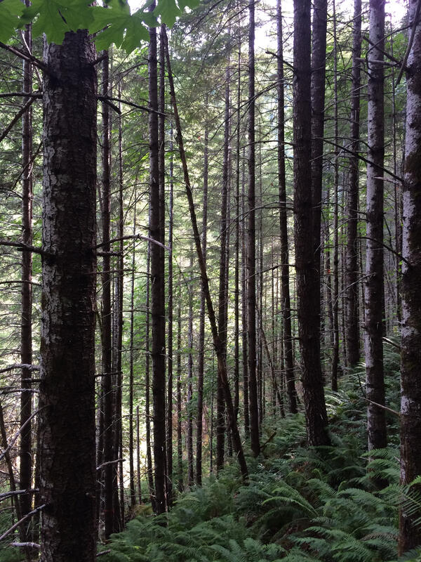
Closed Canopy Plantation
Example of a closed canopy plantation logged 60 years ago at the HJ Andrews Experimental Forest in Oregon, old growth forests have bigger trees and a more complex understory.

CMHRP scientific investigations help to protect coastal infrastructure
At Fire Island, estuarine, wetland, coastal, and oceanic processes interact, affecting natural and human communities. The CMHRP has been conducting scientific investigations at Fire Island in order to protect coastal infrastructure.
At Fire Island, estuarine, wetland, coastal, and oceanic processes interact, affecting natural and human communities. The CMHRP has been conducting scientific investigations at Fire Island in order to protect coastal infrastructure.

Coastal Strand, Kaloko Honokohau National Historical Park
Dry coastal habitat at Kaloko Honokohau National Historical Park, Big Island, Hawai‘i.
Dry coastal habitat at Kaloko Honokohau National Historical Park, Big Island, Hawai‘i.

Collecting soil cores for a SageSTEP carbon budget study
This auger is used to collect 1 meter deep soil cores for a carbon budget study associated with the SageSTEP project. SageSTEP is a long-term, multi-disciplinary experiment evaluating sagebrush restoration methods in the Great Basin.
This auger is used to collect 1 meter deep soil cores for a carbon budget study associated with the SageSTEP project. SageSTEP is a long-term, multi-disciplinary experiment evaluating sagebrush restoration methods in the Great Basin.

Devil's Backbone Open Space
A landscape view of the "Devil's Backbone" near Loveland, CO.
A landscape view of the "Devil's Backbone" near Loveland, CO.

Digital Elevation Model for Newberry Volcano and vicinity.
High-resolution digital elevation dataset for Newberry Volcano and vicinity, Oregon, based on lidar survey of August-September, 2010 and bathymetric survey of June, 2001.
High-resolution digital elevation dataset for Newberry Volcano and vicinity, Oregon, based on lidar survey of August-September, 2010 and bathymetric survey of June, 2001.

Dissected bat guano pellet showing antennae, eyes, and body parts
Dissected guano pellet showing antennae, eyes, and body fragments of midges.
Dissected guano pellet showing antennae, eyes, and body fragments of midges.

Drinking water from tap
The quality of the water we drink can potentially impact our health. The USGS has several programs and cooperative projects that characterize the quality of selected rivers and aquifers used as sources of drinking water to community water systems in the United States.
The quality of the water we drink can potentially impact our health. The USGS has several programs and cooperative projects that characterize the quality of selected rivers and aquifers used as sources of drinking water to community water systems in the United States.

Drowned Forest in Girdwood, AK from 1964 Alaska Earthquake and Tsunami
Shaking during the 1964 Alaska earthquake was felt as far away as Seattle, Washington, and its tsunamis caused 129 fatalities and about $2.3 billion in property losses (2013 dollars).
Shaking during the 1964 Alaska earthquake was felt as far away as Seattle, Washington, and its tsunamis caused 129 fatalities and about $2.3 billion in property losses (2013 dollars).

Eagle Creek at Zionsville, IN - water quality sonde
Eagle Creek at Zionsville, IN - water quality sonde
Eagle Creek at Zionsville, IN - water quality sonde

Eagle Creek at Zionsville, IN - water quality sonde
Eagle Creek at Zionsville, IN - water quality sonde
Eagle Creek at Zionsville, IN - water quality sonde

Eddy covariance and Multi-GAS stations
Photograph of eddy covariance and Multi-GAS stations that were deployed in a temporary configuration near Norris Geyser Basin in 2016. Research conducted under permit YELL-2016-SCI-7082.
Photograph of eddy covariance and Multi-GAS stations that were deployed in a temporary configuration near Norris Geyser Basin in 2016. Research conducted under permit YELL-2016-SCI-7082.

Edwin B Forsythe National Wildlife Refuge study area
Browse graphic of Edwin B Forsythe National Wildlife Refuge study area
Browse graphic of Edwin B Forsythe National Wildlife Refuge study area

Elbaite
Elbaite is one of the best-known members of the tourmaline mineral family, particularly for its high-quality gemstones. Read more about the tourmaline mineral family here.
Elbaite is one of the best-known members of the tourmaline mineral family, particularly for its high-quality gemstones. Read more about the tourmaline mineral family here.

Epidote and Quartz
Epidote is a silicate mineral used mostly as a semiprecious gemstone.
Sample provided by Carlin Green, USGS. Sample originated from Prince of Wales Island, Alaska, and is 6.0cm in size.
Epidote is a silicate mineral used mostly as a semiprecious gemstone.
Sample provided by Carlin Green, USGS. Sample originated from Prince of Wales Island, Alaska, and is 6.0cm in size.

Equipment used during surveys in Columbia River littoral cell
Photographs showing equipment used during bathymetric and topographic surveys along the Columbia River littoral cell, Washington and Oregon.
Photographs showing equipment used during bathymetric and topographic surveys along the Columbia River littoral cell, Washington and Oregon.

Erika Lozano, Marcie Cruz, and Emma Hanslowe prepare a tegu lizard
Erika Lozano, Marcie Cruz, and Emma Hanslowe (L-R), prepare an Argentine black-and-white tegu (Tupinambis merianae) for surgery as part of a study on cold-weather behavior on the lizards.
Erika Lozano, Marcie Cruz, and Emma Hanslowe (L-R), prepare an Argentine black-and-white tegu (Tupinambis merianae) for surgery as part of a study on cold-weather behavior on the lizards.

Flow banding of Panum pumice and obsidian
Flow banding of Panum pumice and obsidian of the same composition.
Flow banding of Panum pumice and obsidian of the same composition.

Flowmeter cooperator
Inline water-use flow meter being installed by Lower Mississippi-Gulf and Arkansas Natural Resources Commission staff
Inline water-use flow meter being installed by Lower Mississippi-Gulf and Arkansas Natural Resources Commission staff

Frosted flatwoods salamander
Frosted flatwoods salamander in St. Marks National Wildlife Refuge, Florida
Frosted flatwoods salamander in St. Marks National Wildlife Refuge, Florida

Frosted flatwoods salamander
Frosted flatwoods salamander, St. Marks National Wildlife Refuge, Florida
Frosted flatwoods salamander, St. Marks National Wildlife Refuge, Florida