
Debris flow deposits caused by intense rainfall in April 2020 block a highway in Macon County, NC.
Images
Browse our photos of landslide research and post-landslide investigations.
Filter Total Items: 266

Debris flow road damage - Macon County, NC
Debris flow deposits caused by intense rainfall in April 2020 block a highway in Macon County, NC.

Rainfall-triggered debris flow - Macon County, NC
Debris flow caused by intense rainfall in April 2020 in Macon County, NC.
Debris flow caused by intense rainfall in April 2020 in Macon County, NC.

On a hillside in Las Marias, USGS scientists examine landslide effects
On a hillside in Las Marias, USGS scientists examine landslide effectsUSGS ground failure experts examine landslides after Hurricane Maria in the municipality of Las Marias, Puerto Rico.
On a hillside in Las Marias, USGS scientists examine landslide effects
On a hillside in Las Marias, USGS scientists examine landslide effectsUSGS ground failure experts examine landslides after Hurricane Maria in the municipality of Las Marias, Puerto Rico.

A helicopter flight reveals landslides' damage in Utuado municipality
A helicopter flight reveals landslides' damage in Utuado municipalityAn aerial view of landslide damage after Hurricane Maria in Utuado municipality, Puerto Rico.
A helicopter flight reveals landslides' damage in Utuado municipality
A helicopter flight reveals landslides' damage in Utuado municipalityAn aerial view of landslide damage after Hurricane Maria in Utuado municipality, Puerto Rico.

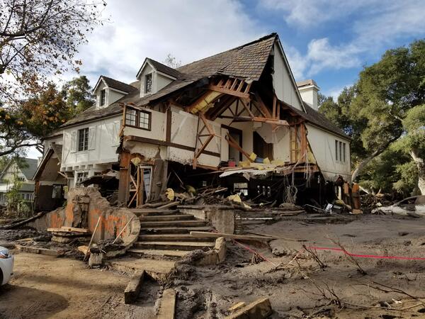
Home damaged by post-wildfire debris flow in Montecito, CA.
Home damaged by post-wildfire debris flow in Montecito, CA.Damage from a major post-wildfire landslide that occurred on 9 January 2018 near Montecito, Santa Barbara County as a result of the 2017 Thomas Fire.
Home damaged by post-wildfire debris flow in Montecito, CA.
Home damaged by post-wildfire debris flow in Montecito, CA.Damage from a major post-wildfire landslide that occurred on 9 January 2018 near Montecito, Santa Barbara County as a result of the 2017 Thomas Fire.

Debris flow after the 2003 Old Gran Prix fire
Damage from a major post-wildfire landslide that occurred on 25 December 2003 near Devore, San Bernardino County as a result of the Old/Grand Prix fires that ran through the San Bernardino Mountains.
Damage from a major post-wildfire landslide that occurred on 25 December 2003 near Devore, San Bernardino County as a result of the Old/Grand Prix fires that ran through the San Bernardino Mountains.

Landslide at Howard Gap Road
Northeast Region Photo Contest Winner | June 2019 | USGS at Work
Landslide at Howard Gap Road, Hendersonville NC; People (R to L): Kelsey O'Pry, Corey Scheip, Jesse Hill, Jessica DeWitt; UAV imaging and geologic field observations are done to map the extent and activity of this landslide; Hendersonville, NC

USGS and NBRO Scientists in Sri Lanka
USGS scientists collaborate with Sri Lankan scientists from the National Building Research Organization (NBRO) on the installation of rainfall and soil moisture instrumentation on an active landslide in southwest Sri Lanka. The station provides real-time data including rainfall and soil moisture content of an active landslide.
USGS scientists collaborate with Sri Lankan scientists from the National Building Research Organization (NBRO) on the installation of rainfall and soil moisture instrumentation on an active landslide in southwest Sri Lanka. The station provides real-time data including rainfall and soil moisture content of an active landslide.

Rainfall-triggered debris flow - Powell County, Kentucky
Rainfall-triggered debris flow - Powell County, KentuckyLandslide caused by intense rainfall in June 2019 in Powell County, KY. The landslide completely destroyed the first floor and all that remains in is the second floor of the home, displayed in this image.

Rainfall and Landslides in Northern CA
A debris flow in Marin County triggered by intense rainfall destroyed several homes and injured one person during February 2019. View is looking from the top of the landslide downslope.
A debris flow in Marin County triggered by intense rainfall destroyed several homes and injured one person during February 2019. View is looking from the top of the landslide downslope.

Debris flow road damage - Polk County, NC
Heavy rainfall reactivated the 9 acre Howard Gap Landslide in February 2019, severely damaging a highway in Polk County, NC. This image only shows a small portion of a much larger landslide.
Heavy rainfall reactivated the 9 acre Howard Gap Landslide in February 2019, severely damaging a highway in Polk County, NC. This image only shows a small portion of a much larger landslide.

Landslide near Potter Hill, Anchorage, Alaska
Landslide near Potter Hill, Anchorage, Alaska, after 2018 Anchorage earthquake.
Landslide near Potter Hill, Anchorage, Alaska, after 2018 Anchorage earthquake.

Damage to interior of home following Hurricane Maria - Utuado, Puerto Rico
Damage to interior of home following Hurricane Maria - Utuado, Puerto RicoA landslide caused by intense rainfall from Hurricane Maria in September 2017 in Puerto Rico hit this home, killing three people.
Damage to interior of home following Hurricane Maria - Utuado, Puerto Rico
Damage to interior of home following Hurricane Maria - Utuado, Puerto RicoA landslide caused by intense rainfall from Hurricane Maria in September 2017 in Puerto Rico hit this home, killing three people.

Large crack on hillslope formed in residential yard
Large crack on hillslope formed in residential yardCracks in a hillslope caused by slow landslide movement in Rockcastle County, Kentucky.
Large crack on hillslope formed in residential yard
Large crack on hillslope formed in residential yardCracks in a hillslope caused by slow landslide movement in Rockcastle County, Kentucky.
Montecito home damaged by post-wildfire debrisflow.
Montecito home damaged by post-wildfire debrisflow.Damage from a major post-wildfire landslide that occurred on 9 January 2018 near Montecito, Santa Barbara County as a result of the 2017 Thomas Fire.
Montecito home damaged by post-wildfire debrisflow.
Montecito home damaged by post-wildfire debrisflow.Damage from a major post-wildfire landslide that occurred on 9 January 2018 near Montecito, Santa Barbara County as a result of the 2017 Thomas Fire.

Geologists assess damage after debris-flow event
USGS geologists deployed to Santa Barbara County to support a geohazard assessment of the Montecito area
USGS geologists deployed to Santa Barbara County to support a geohazard assessment of the Montecito area

Pool sign warns first responders
Swimming pool sign spray-painted to warn first responders and others to be careful around the potentially dangerous area.
Swimming pool sign spray-painted to warn first responders and others to be careful around the potentially dangerous area.

Montecito after debris flow
The Dec. 4, 2017 Thomas fire, Southern California's largest wildfire on record, burned more than 280,000 acres across Ventura and Santa Barbara counties for nearly a month.
The Dec. 4, 2017 Thomas fire, Southern California's largest wildfire on record, burned more than 280,000 acres across Ventura and Santa Barbara counties for nearly a month.

Geologists assess scene after debris flow
Geologists assess boulders displaced during the Montecito debris flow event on Jan. 9, 2018.
Geologists assess boulders displaced during the Montecito debris flow event on Jan. 9, 2018.

LS Preliminary Puerto Rico
Excerpt of satellite image showing landslide impacts to roads, agriculture, and a reservoir in the Lares Municipality. Points identify the approximate location of roads visibly impacted by landslides. Image filename contains approximate latitude and longitude of this impact location.
Excerpt of satellite image showing landslide impacts to roads, agriculture, and a reservoir in the Lares Municipality. Points identify the approximate location of roads visibly impacted by landslides. Image filename contains approximate latitude and longitude of this impact location.

Slow landslide building damage - Boyd County, Kentucky
Slow landslide building damage - Boyd County, KentuckyBuilding damage caused by a slow landslide in Boyd County, Kentucky, 2017
Slow landslide building damage - Boyd County, Kentucky
Slow landslide building damage - Boyd County, KentuckyBuilding damage caused by a slow landslide in Boyd County, Kentucky, 2017