
Logo in support of the 7th Federal UxS Users Workshop to be hosted March 16-18, 2027
Matt A Burgess, PhD
Dr. Matthew A. Burgess is a leading expert in uncrewed aircraft systems, specializing in their scientific and environmental applications. As Acting Program Chief of the National Uncrewed Systems Office (NUSO), Matt advances drone technology, data standards, and aviation safety across federal science, shaping the future of remote sensing and UAS operations.
Dr. Matthew A. Burgess is a notable authority in uncrewed aircraft systems (UAS), specializing in their utility to environmental science, remote sensing, and natural resource applications. His expertise is widely sought after in the areas of platform and sensor evaluation, geometric and radiometric calibration, and the operational use of drone-collected data for scientific purposes.
Currently, Dr. Burgess serves as Acting Program Chief of the USGS National Uncrewed Systems Office, which is housed in the Geosciences and Environmental Change Science Center in Denver. During his tenure at the USGS, he has served as a Geographer, Mission Operator, and Geospatial Analyst, performing UAS operations across bureaus of the U.S. Department of the Interior (DOI). Working with UAS since 2004, Matt has been instrumental in designing and executing complex scientific flight missions, systematically evaluating emerging UAS platforms and sensors, and developing data specifications and best practices that influence federal science agencies’ approaches to UAS. His leadership emphasizes operational safety, repeatability, and the transformation of UAS data into rigorous, quantitative scientific products.
Prior to joining USGS, Dr. Burgess coordinated the University of Florida’s UAS Research Program, pioneering early scientific uses of small uncrewed aircraft systems. Matt holds a PhD in Wildlife Ecology and Conservation, an MS in Interdisciplinary Ecology, and a BS in Zoology, all from the University of Florida. His broad academic background enables him to connect scientific specializations with remote sensing and aviation operations, making a meaningful impact on the DOI’s priorities.
Dr. Burgess is recognized for his achievements in sensor validation, advancing workflows for multispectral and hyperspectral data, characterizing mine waste, and integrating UAS data into national mapping projects. In addition to his technical skills, Matt routinely serves as a speaker and consultant helping shape the next generation of uncrewed system operators and encouraging a culture of safety within the DOI and its partners.
Science and Products
7th Federal UxS Workshop
The Federal Uncrewed Systems (UxS) Workshop convenes government and academic partners to advance safe, effective, and mission-ready applications of uncrewed aerial, ground, and maritime systems. By fostering interagency collaboration, university research integration, and evidence‑based operational practices, we accelerate scientific discovery, environmental monitoring and hazard response, policy...

National Uncrewed Systems Office
The U.S. Geological Survey (USGS) National Uncrewed Systems Office (NUSO) leads the research activities needed to make Uncrewed Aircraft Systems (UAS) data collection an efficient, safe, and cost-effective remote sensing tool for Department of the Interior (DOI) and USGS scientists.
7th Federal UxS Users Workshop
Logo in support of the 7th Federal UxS Users Workshop to be hosted March 16-18, 2027

B-Roll: 2025 UAS radiometric calibration and validation research in Golden, Colorado
B-Roll: 2025 UAS radiometric calibration and validation research in Golden, ColoradoCalibration and validation (cal/val) are essential steps to ensure that remotely sensed data are reliable for scientific use. Radiometric cal/val involves converting digital image pixel values to meaningful units and assessing their accuracy.
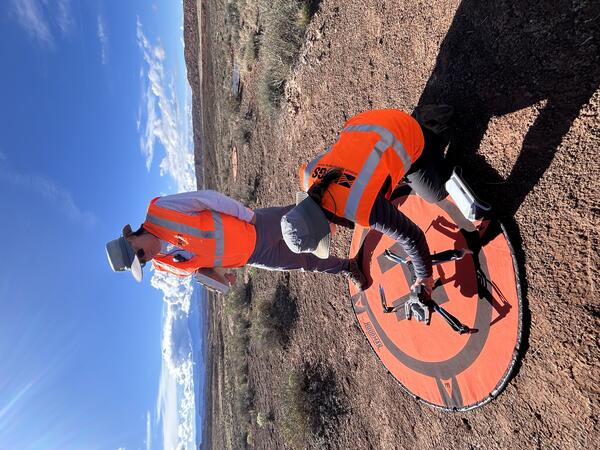
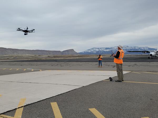
Setting up equipment for drone mapping flight near Moab, Utah
Setting up equipment for drone mapping flight near Moab, UtahUSGS remote pilots Matt Burgess and Victoria Scholl prepare to conduct a drone mapping flight to collect thermal imagery over a dryland study site near Moab, Utah.
Setting up equipment for drone mapping flight near Moab, Utah
Setting up equipment for drone mapping flight near Moab, UtahUSGS remote pilots Matt Burgess and Victoria Scholl prepare to conduct a drone mapping flight to collect thermal imagery over a dryland study site near Moab, Utah.

Assessing road damage caused by Hurricane Helene
The U.S. Geological Survey (USGS) employs a range of drone technologies for data collection in science, mapping, and monitoring.
The U.S. Geological Survey (USGS) employs a range of drone technologies for data collection in science, mapping, and monitoring.

Using uncrewed aircraft in landslide assessment
The Blue Ridge Parkway is renowned for its winding path through the rugged Appalachian Mountains. The steep terrain and dense forests make for scenic views but also create a challenging environment for drone operations. U.S. Geological Survey (USGS) remote pilots seek out open areas from which to conduct flights to enable good visibility of their surroundings.
The Blue Ridge Parkway is renowned for its winding path through the rugged Appalachian Mountains. The steep terrain and dense forests make for scenic views but also create a challenging environment for drone operations. U.S. Geological Survey (USGS) remote pilots seek out open areas from which to conduct flights to enable good visibility of their surroundings.

Uncrewed aircraft pilots at the Tanbark Ridge Overlook
Uncrewed aircraft pilots at the Tanbark Ridge OverlookU.S. Geological Survey (USGS) remote pilots Joe Adams and Matthew Burgess prepare to conduct drone flights at the Tanbark Ridge Overlook along the Blue Ridge Parkway in North Carolina.
Uncrewed aircraft pilots at the Tanbark Ridge Overlook
Uncrewed aircraft pilots at the Tanbark Ridge OverlookU.S. Geological Survey (USGS) remote pilots Joe Adams and Matthew Burgess prepare to conduct drone flights at the Tanbark Ridge Overlook along the Blue Ridge Parkway in North Carolina.

Road damaged by landslide
In September 2024, Hurricane Helene brought heavy rain and powerful winds, resulting in multiple landslides along the iconic Blue Ridge Parkway. The National Park Service requested technical assistance from the U.S.
In September 2024, Hurricane Helene brought heavy rain and powerful winds, resulting in multiple landslides along the iconic Blue Ridge Parkway. The National Park Service requested technical assistance from the U.S.

Preparing to assess road damage using a drone
In September 2024, Hurricane Helene brought heavy rain and powerful winds, resulting in multiple landslides along the iconic Blue Ridge Parkway. The National Park Service requested technical assistance from the U.S.
In September 2024, Hurricane Helene brought heavy rain and powerful winds, resulting in multiple landslides along the iconic Blue Ridge Parkway. The National Park Service requested technical assistance from the U.S.

Attendees of the 6th Federal Uncrewed Systems (UxS) Users Workshop
Attendees of the 6th Federal Uncrewed Systems (UxS) Users WorkshopAerial photo of attendees at the 6th Federal Uncrewed Systems (UxS) Workshop taken from a Skydio drone in front of the Science and Technology building at the Southwestern Indian Polytechnic Institute, Albuquerque, New Mexico.
Drone with Gamma Ray Spectrometer
Gamma Ray Spectrometer on drone in New Mexico.
Gamma Ray Spectrometer on drone in New Mexico.

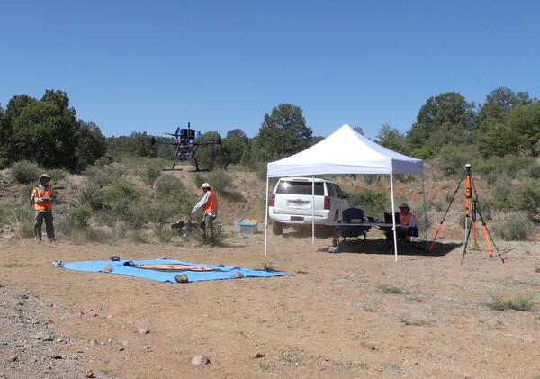
UAS Radiometric Calibration Research in South Dakota, July 2023
UAS Radiometric Calibration Research in South Dakota, July 2023In July 2023, the U.S. Geological Survey (USGS) National Uncrewed Systems Office (NUSO) and the USGS Earth Resources Observation and Science (EROS) Center conducted a joint field campaign in Sioux Falls, South Dakota.
Drone being flown for instrument testing
Gamma Ray Spectrometer testing at DOE Environmental Radiation Calibration Facility located on Grand Junction Airport.
Gamma Ray Spectrometer testing at DOE Environmental Radiation Calibration Facility located on Grand Junction Airport.
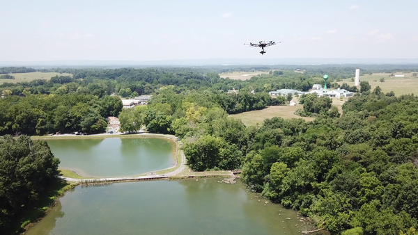
Hyperspectral data collection with drone aircraft
Uncrewed aircraft system (UAS) hyperspectral data collection flight over a reservoir at the Eastern USGS Eastern Ecological Science Center - Leetown Research Laboratory (EESC-LRL) in West Virginia.
Uncrewed aircraft system (UAS) hyperspectral data collection flight over a reservoir at the Eastern USGS Eastern Ecological Science Center - Leetown Research Laboratory (EESC-LRL) in West Virginia.

Group photo 2 by Matt Burgess NUSO_Cropped.jpg
In this photo, a group of 20 scientists pose for the camera. The group is dressed in winter gear and stands in front of Berthoud Pass, Colorado. The pass and the ground are covered in snow. Berthoud Pass has a few patches of dark green trees.
In this photo, a group of 20 scientists pose for the camera. The group is dressed in winter gear and stands in front of Berthoud Pass, Colorado. The pass and the ground are covered in snow. Berthoud Pass has a few patches of dark green trees.

Group photo 2 by Matt Burgess NUSO.JPG
The Snow to Flow team is comprised of a “village” of remarkable scientists and engineers from the USGS Colorado Water Science Center, USGS National Uncrewed Systems Office (NUSO), and the University of Southern California - Viterbi School of Engineering. The team is pictured here at the Berthoud Pass, CO field site on April 18, 2022.
The Snow to Flow team is comprised of a “village” of remarkable scientists and engineers from the USGS Colorado Water Science Center, USGS National Uncrewed Systems Office (NUSO), and the University of Southern California - Viterbi School of Engineering. The team is pictured here at the Berthoud Pass, CO field site on April 18, 2022.
Science and Products
7th Federal UxS Workshop
The Federal Uncrewed Systems (UxS) Workshop convenes government and academic partners to advance safe, effective, and mission-ready applications of uncrewed aerial, ground, and maritime systems. By fostering interagency collaboration, university research integration, and evidence‑based operational practices, we accelerate scientific discovery, environmental monitoring and hazard response, policy...
National Uncrewed Systems Office
The U.S. Geological Survey (USGS) National Uncrewed Systems Office (NUSO) leads the research activities needed to make Uncrewed Aircraft Systems (UAS) data collection an efficient, safe, and cost-effective remote sensing tool for Department of the Interior (DOI) and USGS scientists.
7th Federal UxS Users Workshop
Logo in support of the 7th Federal UxS Users Workshop to be hosted March 16-18, 2027
Logo in support of the 7th Federal UxS Users Workshop to be hosted March 16-18, 2027
B-Roll: 2025 UAS radiometric calibration and validation research in Golden, Colorado
B-Roll: 2025 UAS radiometric calibration and validation research in Golden, ColoradoCalibration and validation (cal/val) are essential steps to ensure that remotely sensed data are reliable for scientific use. Radiometric cal/val involves converting digital image pixel values to meaningful units and assessing their accuracy.
Setting up equipment for drone mapping flight near Moab, Utah
Setting up equipment for drone mapping flight near Moab, UtahUSGS remote pilots Matt Burgess and Victoria Scholl prepare to conduct a drone mapping flight to collect thermal imagery over a dryland study site near Moab, Utah.
Setting up equipment for drone mapping flight near Moab, Utah
Setting up equipment for drone mapping flight near Moab, UtahUSGS remote pilots Matt Burgess and Victoria Scholl prepare to conduct a drone mapping flight to collect thermal imagery over a dryland study site near Moab, Utah.
Assessing road damage caused by Hurricane Helene
The U.S. Geological Survey (USGS) employs a range of drone technologies for data collection in science, mapping, and monitoring.
The U.S. Geological Survey (USGS) employs a range of drone technologies for data collection in science, mapping, and monitoring.
Using uncrewed aircraft in landslide assessment
The Blue Ridge Parkway is renowned for its winding path through the rugged Appalachian Mountains. The steep terrain and dense forests make for scenic views but also create a challenging environment for drone operations. U.S. Geological Survey (USGS) remote pilots seek out open areas from which to conduct flights to enable good visibility of their surroundings.
The Blue Ridge Parkway is renowned for its winding path through the rugged Appalachian Mountains. The steep terrain and dense forests make for scenic views but also create a challenging environment for drone operations. U.S. Geological Survey (USGS) remote pilots seek out open areas from which to conduct flights to enable good visibility of their surroundings.
Uncrewed aircraft pilots at the Tanbark Ridge Overlook
Uncrewed aircraft pilots at the Tanbark Ridge OverlookU.S. Geological Survey (USGS) remote pilots Joe Adams and Matthew Burgess prepare to conduct drone flights at the Tanbark Ridge Overlook along the Blue Ridge Parkway in North Carolina.
Uncrewed aircraft pilots at the Tanbark Ridge Overlook
Uncrewed aircraft pilots at the Tanbark Ridge OverlookU.S. Geological Survey (USGS) remote pilots Joe Adams and Matthew Burgess prepare to conduct drone flights at the Tanbark Ridge Overlook along the Blue Ridge Parkway in North Carolina.
Road damaged by landslide
In September 2024, Hurricane Helene brought heavy rain and powerful winds, resulting in multiple landslides along the iconic Blue Ridge Parkway. The National Park Service requested technical assistance from the U.S.
In September 2024, Hurricane Helene brought heavy rain and powerful winds, resulting in multiple landslides along the iconic Blue Ridge Parkway. The National Park Service requested technical assistance from the U.S.
Preparing to assess road damage using a drone
In September 2024, Hurricane Helene brought heavy rain and powerful winds, resulting in multiple landslides along the iconic Blue Ridge Parkway. The National Park Service requested technical assistance from the U.S.
In September 2024, Hurricane Helene brought heavy rain and powerful winds, resulting in multiple landslides along the iconic Blue Ridge Parkway. The National Park Service requested technical assistance from the U.S.
Attendees of the 6th Federal Uncrewed Systems (UxS) Users Workshop
Attendees of the 6th Federal Uncrewed Systems (UxS) Users WorkshopAerial photo of attendees at the 6th Federal Uncrewed Systems (UxS) Workshop taken from a Skydio drone in front of the Science and Technology building at the Southwestern Indian Polytechnic Institute, Albuquerque, New Mexico.
Drone with Gamma Ray Spectrometer
Gamma Ray Spectrometer on drone in New Mexico.
Gamma Ray Spectrometer on drone in New Mexico.
UAS Radiometric Calibration Research in South Dakota, July 2023
UAS Radiometric Calibration Research in South Dakota, July 2023In July 2023, the U.S. Geological Survey (USGS) National Uncrewed Systems Office (NUSO) and the USGS Earth Resources Observation and Science (EROS) Center conducted a joint field campaign in Sioux Falls, South Dakota.
Drone being flown for instrument testing
Gamma Ray Spectrometer testing at DOE Environmental Radiation Calibration Facility located on Grand Junction Airport.
Gamma Ray Spectrometer testing at DOE Environmental Radiation Calibration Facility located on Grand Junction Airport.
Hyperspectral data collection with drone aircraft
Uncrewed aircraft system (UAS) hyperspectral data collection flight over a reservoir at the Eastern USGS Eastern Ecological Science Center - Leetown Research Laboratory (EESC-LRL) in West Virginia.
Uncrewed aircraft system (UAS) hyperspectral data collection flight over a reservoir at the Eastern USGS Eastern Ecological Science Center - Leetown Research Laboratory (EESC-LRL) in West Virginia.
Group photo 2 by Matt Burgess NUSO_Cropped.jpg
In this photo, a group of 20 scientists pose for the camera. The group is dressed in winter gear and stands in front of Berthoud Pass, Colorado. The pass and the ground are covered in snow. Berthoud Pass has a few patches of dark green trees.
In this photo, a group of 20 scientists pose for the camera. The group is dressed in winter gear and stands in front of Berthoud Pass, Colorado. The pass and the ground are covered in snow. Berthoud Pass has a few patches of dark green trees.
Group photo 2 by Matt Burgess NUSO.JPG
The Snow to Flow team is comprised of a “village” of remarkable scientists and engineers from the USGS Colorado Water Science Center, USGS National Uncrewed Systems Office (NUSO), and the University of Southern California - Viterbi School of Engineering. The team is pictured here at the Berthoud Pass, CO field site on April 18, 2022.
The Snow to Flow team is comprised of a “village” of remarkable scientists and engineers from the USGS Colorado Water Science Center, USGS National Uncrewed Systems Office (NUSO), and the University of Southern California - Viterbi School of Engineering. The team is pictured here at the Berthoud Pass, CO field site on April 18, 2022.