
Wesley Daniel, Ph.D.
Wesley Daniel is a Fishery Biologist at the USGS Wetland and Aquatic Research Center, and leads the USGS Nonindigenous Aquatic Species Database.
Science and Products
Filter Total Items: 24
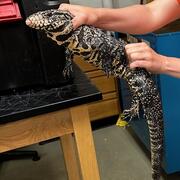
Early detection and rapid response tools for invasive tegu lizards
Scientists at USGS have shown that much of the US is suitable for invasion by tegu lizards, and suitability will likely increase in the future. While tegus can be removed via trapping, it is difficult to monitor every geographic area where tegus could invade. Thus, methods for quickly detecting and removing tegus in new areas are the best way to prevent spread and minimize damage from these...

Developing a Process for Listing Injurious Wildlife Species
This project will develop a transparent process for prioritizing species for listing as injurious, likely to cause damage or harm, under the Lacey Act. Building upon previously developed "horizon scan" and "watchlist" products, this process will identify potentially invasive species that present the greatest risk to lands, waters, and other assets managed by the U.S. Department of the Interior.

Using Multiple Indicators to Assess Stream Condition in the Chesapeake Bay
USGS is working with federal, state and local partners to develop multiple assessments of stream and river conditions in non-tidal areas of the Chesapeake Bay watershed. These assessments will help managers preserve stream health and improve biological conditions in impaired streams as the human population and climate continue to change in this region.

Assessing Risk Communication in the Pet and Aquarium Trade: An Analysis of Outreach and Engagement Efforts
WARC researchers evaluated whether outreach campaigns targeting pet owners are effectively reaching their desired audiences, namely pet owners who might unintentionally or purposefully release their pet into the wild.

Future Aquatic Invaders of the Northeast U.S.: How Climate Change, Human Vectors, and Natural History Could Bring Southern and Western Species North
Researchers will evaluate the potential of aquatic species to invade the Northeast U.S. Following the identification of appropriate target species by regional stakeholders, researchers will gather data from the NAS database and develop models to determine habitat suitability for each species.

Integration of Environmental DNA (eDNA) Data into the USGS Nonindigenous Aquatic Species Database
USGS and Department of the Interior partners have added a new, advanced capability to the early detection and rapid response tool set – the integration of environmental DNA and sighting data in the USGS Nonindigenous Aquatic Species database.

Predicting Climate-Driven Invasive Fish Spread to Support Indigenous and State Freshwater Management in Florida
Project Overview Climate change and invasive fish species threaten the resilience and biodiversity of freshwater ecosystems in the Southeastern U.S., including the Everglades, which are vital to the Miccosukee Tribe of Indians of Florida. Researchers supported by this Southeast CASC project will model invasive fish distributions under changing climate conditions and refine the model...

Phase Two: Accelerating the Scale and Impact of the Southeast Regional Invasive Species and Climate Change Management Network (SE RISCC)
An invasive species is a species that is not native to a location and that rapidly grows and spreads in its new range, often damaging native plants and wildlife. At present, the southeastern USA harbors thousands of invasive plants and animals, which were introduced intentionally through the plant and pet trade or unintentionally through other forms of commercial trade. Many of these...

Climate matching with the climatchR R package
Climate matching is a method for understanding species distributions and ranges and may be used as part of horizon scanning. Horizon scanning is the process of examining potential risk of invasion of new invasive species. Preventing new invasive species invasion requires less time and resources than attempting to control and remove established invasive species. Horizon scanning allows resource...

AquaDePTH-Aquatic Disease and Pathogen Repository
The Aquatic Disease and Pathogen Repository (AquaDePTH) will be a public-facing national repository to support biosurveillance of aquatic animal diseases and pathogens. By collating historically published data, plus new aquatic pathogen and disease information, stakeholders will be able monitor fish kill and aquatic pathogen trends spatially and temporally in freshwater and marine environments...

Future Aquatic Invaders of the Northeast U.S.: How Climate Change, Human Vectors, and Natural History Could Bring Southern and Western Species North
There are significant investments by states and resource agencies in the northeast U.S. for invasive aquatic species monitoring and management. These investments in jurisdictional waters help maintain their use for drinking, industry, and recreation. It is essential to understand the risks from invasive species, because once established, species can be costly to society and difficult or...
Phase One: Southeast Regional Invasive Species and Climate Change Management Network (SE RISCC)
Climate change is expected to worsen the harmful effects of invasive species on native wildlife. This presents a growing conservation challenge for invasive species managers in the southeastern United States where thousands of invasive species exist. While many of these invasive species currently have relatively small ranges in the southeastern U.S., climate change may allow them to...
Science and Products
Filter Total Items: 24
Early detection and rapid response tools for invasive tegu lizards
Scientists at USGS have shown that much of the US is suitable for invasion by tegu lizards, and suitability will likely increase in the future. While tegus can be removed via trapping, it is difficult to monitor every geographic area where tegus could invade. Thus, methods for quickly detecting and removing tegus in new areas are the best way to prevent spread and minimize damage from these...
Developing a Process for Listing Injurious Wildlife Species
This project will develop a transparent process for prioritizing species for listing as injurious, likely to cause damage or harm, under the Lacey Act. Building upon previously developed "horizon scan" and "watchlist" products, this process will identify potentially invasive species that present the greatest risk to lands, waters, and other assets managed by the U.S. Department of the Interior.
Using Multiple Indicators to Assess Stream Condition in the Chesapeake Bay
USGS is working with federal, state and local partners to develop multiple assessments of stream and river conditions in non-tidal areas of the Chesapeake Bay watershed. These assessments will help managers preserve stream health and improve biological conditions in impaired streams as the human population and climate continue to change in this region.
Assessing Risk Communication in the Pet and Aquarium Trade: An Analysis of Outreach and Engagement Efforts
WARC researchers evaluated whether outreach campaigns targeting pet owners are effectively reaching their desired audiences, namely pet owners who might unintentionally or purposefully release their pet into the wild.
Future Aquatic Invaders of the Northeast U.S.: How Climate Change, Human Vectors, and Natural History Could Bring Southern and Western Species North
Researchers will evaluate the potential of aquatic species to invade the Northeast U.S. Following the identification of appropriate target species by regional stakeholders, researchers will gather data from the NAS database and develop models to determine habitat suitability for each species.
Integration of Environmental DNA (eDNA) Data into the USGS Nonindigenous Aquatic Species Database
USGS and Department of the Interior partners have added a new, advanced capability to the early detection and rapid response tool set – the integration of environmental DNA and sighting data in the USGS Nonindigenous Aquatic Species database.
Predicting Climate-Driven Invasive Fish Spread to Support Indigenous and State Freshwater Management in Florida
Project Overview Climate change and invasive fish species threaten the resilience and biodiversity of freshwater ecosystems in the Southeastern U.S., including the Everglades, which are vital to the Miccosukee Tribe of Indians of Florida. Researchers supported by this Southeast CASC project will model invasive fish distributions under changing climate conditions and refine the model...
Phase Two: Accelerating the Scale and Impact of the Southeast Regional Invasive Species and Climate Change Management Network (SE RISCC)
An invasive species is a species that is not native to a location and that rapidly grows and spreads in its new range, often damaging native plants and wildlife. At present, the southeastern USA harbors thousands of invasive plants and animals, which were introduced intentionally through the plant and pet trade or unintentionally through other forms of commercial trade. Many of these...
Climate matching with the climatchR R package
Climate matching is a method for understanding species distributions and ranges and may be used as part of horizon scanning. Horizon scanning is the process of examining potential risk of invasion of new invasive species. Preventing new invasive species invasion requires less time and resources than attempting to control and remove established invasive species. Horizon scanning allows resource...
AquaDePTH-Aquatic Disease and Pathogen Repository
The Aquatic Disease and Pathogen Repository (AquaDePTH) will be a public-facing national repository to support biosurveillance of aquatic animal diseases and pathogens. By collating historically published data, plus new aquatic pathogen and disease information, stakeholders will be able monitor fish kill and aquatic pathogen trends spatially and temporally in freshwater and marine environments...
Future Aquatic Invaders of the Northeast U.S.: How Climate Change, Human Vectors, and Natural History Could Bring Southern and Western Species North
There are significant investments by states and resource agencies in the northeast U.S. for invasive aquatic species monitoring and management. These investments in jurisdictional waters help maintain their use for drinking, industry, and recreation. It is essential to understand the risks from invasive species, because once established, species can be costly to society and difficult or...
Phase One: Southeast Regional Invasive Species and Climate Change Management Network (SE RISCC)
Climate change is expected to worsen the harmful effects of invasive species on native wildlife. This presents a growing conservation challenge for invasive species managers in the southeastern United States where thousands of invasive species exist. While many of these invasive species currently have relatively small ranges in the southeastern U.S., climate change may allow them to...