
Resembling splotches of yellow and green paint, salt-encrusted seasonal lakes dot the floor of Western Australia's Shoemaker impact structure. The structure was formed about 1.7 billion years ago and is currently the oldest known impact site in Australia.
Images
Peruse our selection of remote sensing and Earth science imagery below.
Filter Total Items: 865

Shoemaker Crater
Resembling splotches of yellow and green paint, salt-encrusted seasonal lakes dot the floor of Western Australia's Shoemaker impact structure. The structure was formed about 1.7 billion years ago and is currently the oldest known impact site in Australia.

Senegal vegetation - 1994
A scene along a road in Senegal, photographed in 1994 by U.S. Geological Survey Scientist G. Gray Tappan as part of his work on West African land cover. Tappan photographed the scene again in 2004.
A scene along a road in Senegal, photographed in 1994 by U.S. Geological Survey Scientist G. Gray Tappan as part of his work on West African land cover. Tappan photographed the scene again in 2004.

Screenshot of 1992 Land Remote Sensing Policy Act Congressional Record
Screenshot of 1992 Land Remote Sensing Policy Act Congressional RecordThis is a screenshot of 1992 Land Remote Sensing Policy Act Congressional Record. The full document is available below.
Screenshot of 1992 Land Remote Sensing Policy Act Congressional Record
Screenshot of 1992 Land Remote Sensing Policy Act Congressional RecordThis is a screenshot of 1992 Land Remote Sensing Policy Act Congressional Record. The full document is available below.
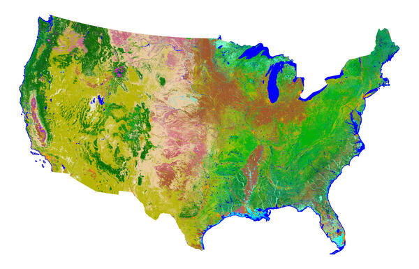
NLCD 1992
The first National Land Cover Dataset (NLCD), based on Landsat 5 data, is completed and available for distribution in 2000.
The first National Land Cover Dataset (NLCD), based on Landsat 5 data, is completed and available for distribution in 2000.
1991 Landsat Image of the Batagaika Crater
Sometimes described as resembling a stingray or a tadpole, the Batagaika Crater is a widening chasm in Siberia and the world’s largest permafrost crater.
Sometimes described as resembling a stingray or a tadpole, the Batagaika Crater is a widening chasm in Siberia and the world’s largest permafrost crater.

Five Millionth Scene
The Landsat Global Archive Consolidation initiative has retrieved and ingested its 5 millionth image since it began in 2010. The data came from the Riyadh Ground Station in Saudi Arabia and was acquired by Landsat 5 on April 16, 1989. It shows an area over Bahrain, Qatar, and Saudi Arabia.
The Landsat Global Archive Consolidation initiative has retrieved and ingested its 5 millionth image since it began in 2010. The data came from the Riyadh Ground Station in Saudi Arabia and was acquired by Landsat 5 on April 16, 1989. It shows an area over Bahrain, Qatar, and Saudi Arabia.

1986 Landsat 5 image of Chernobyl after the
A Landsat 5 image of the Chernobyl Nuclear Power Plant site in Ukraine on April 29, 1986, three days after the accident, shows no warmth in the cooling pond.
A Landsat 5 image of the Chernobyl Nuclear Power Plant site in Ukraine on April 29, 1986, three days after the accident, shows no warmth in the cooling pond.

1985 Public Law 98-365 The Land Remote Sensing Commercialization Act
1985 Public Law 98-365 The Land Remote Sensing Commercialization ActScreenshot of the 1985 Public Law 98-365 The Land Remote Sensing Commercialization Act Memo
1985 Public Law 98-365 The Land Remote Sensing Commercialization Act
1985 Public Law 98-365 The Land Remote Sensing Commercialization ActScreenshot of the 1985 Public Law 98-365 The Land Remote Sensing Commercialization Act Memo

EROS Employee Holding Fish from Pond
EROS Employee Aaron Neugebauer holding fish from the EROS pond.
EROS Employee Aaron Neugebauer holding fish from the EROS pond.
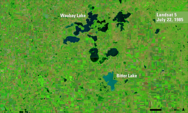
1985 Landsat 5 image of Day County, SD
A false color Landsat 5 image from July 22, 1985, of Waubay Lake and Bitter Lake in Day County, South Dakota.
A false color Landsat 5 image from July 22, 1985, of Waubay Lake and Bitter Lake in Day County, South Dakota.

Algerian Abstract
What look like pale yellow paint streaks slashing through a mosaic of mottled colors are ridges of wind-blown sand that make up Erg Iguidi, an area of ever-shifting sand dunes extending from Algeria into Mauritania in northwestern Africa.
What look like pale yellow paint streaks slashing through a mosaic of mottled colors are ridges of wind-blown sand that make up Erg Iguidi, an area of ever-shifting sand dunes extending from Algeria into Mauritania in northwestern Africa.

Sierra de Velasco
Shimmering blues and greens accentuate the textures of the Sierra de Velasco Mountains of northern Argentina. The urban area (pinkish circle) near the lower left part of the mountain range is La Rioja, the capital of the province of La Rioja.
Shimmering blues and greens accentuate the textures of the Sierra de Velasco Mountains of northern Argentina. The urban area (pinkish circle) near the lower left part of the mountain range is La Rioja, the capital of the province of La Rioja.

1984 Historical Restoration Includes Sioux Falls - B
1984 Historical Restoration Includes Sioux Falls - BHistorical Restoration Includes Sioux Falls (E-651-810BN) B
1984 Historical Restoration Includes Sioux Falls - B
1984 Historical Restoration Includes Sioux Falls - BHistorical Restoration Includes Sioux Falls (E-651-810BN) B

1984 Washington DC EPA Low Oblique
1984 Washington DC EPA Low Oblique

1984 Sioux Falls SD Made from CIR Aircraft
Sioux Falls SD, image from CIR Aircraft (E-640-99BN)
Sioux Falls SD, image from CIR Aircraft (E-640-99BN)

1984 International Remote Sensing Workshop Poster - 72dpi
1984 International Remote Sensing Workshop Poster - 72dpi1984 International Remote Sensing Workshop Poster
1984 International Remote Sensing Workshop Poster - 72dpi
1984 International Remote Sensing Workshop Poster - 72dpi1984 International Remote Sensing Workshop Poster

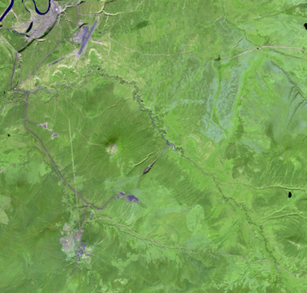
Mount Elgon
Clouds encircle the lofty rim of Africa's Mount Elgon, a huge, long-extinct volcano on the border between Uganda and Kenya. The solitary volcano has one of the world's largest intact calderas, a cauldron-like central depression.
Clouds encircle the lofty rim of Africa's Mount Elgon, a huge, long-extinct volcano on the border between Uganda and Kenya. The solitary volcano has one of the world's largest intact calderas, a cauldron-like central depression.

Landsat 4 First Light Image over western Lake Erie
Landsat 4 First Light Image over western Lake ErieLandsat 4's first light image captured eastern Lake Erie, and the cities of Toledo, Detroit, and Windsor on July 25, 1982. Although the Landsat program had been collecting images of the Earth since 1972, this was the first time that the data could be depicted as a natural color image due to the new Thematic Mapper sensor onboard Landsat 4.

Landsat 4 First Light Image of Detroit
The first Landsat 4 image was acquired over western Lake Erie on July 25, 1982, just 9 days after launch. This image shows the Detroit River dividing the metropolitan areas of Detroit, Michigan and Windsor, Ontario while acting as a strait between Lake Erie and Lake St. Clair.
The first Landsat 4 image was acquired over western Lake Erie on July 25, 1982, just 9 days after launch. This image shows the Detroit River dividing the metropolitan areas of Detroit, Michigan and Windsor, Ontario while acting as a strait between Lake Erie and Lake St. Clair.
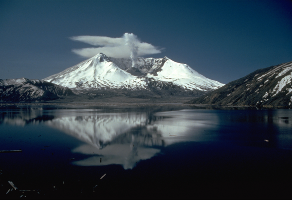
Mount St. Helens after the 1980 eruption
This photo shows Mount St. Helens in 1982, 2 years after the volcano erupted on May 18, 1980. Spirit Lake is in the foreground.
Compare this picture to one taken in 1980 before the eruption to see the changes made to the landscape.
This photo shows Mount St. Helens in 1982, 2 years after the volcano erupted on May 18, 1980. Spirit Lake is in the foreground.
Compare this picture to one taken in 1980 before the eruption to see the changes made to the landscape.
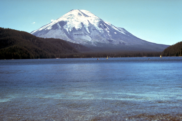
Mount St. Helens Before the 1980 Eruption
This photo shows Mount St. Helens before the volcano erupted on May 18, 1980. Spirit Lake is in the foreground.
Compare this picture to one taken in 1982 to see the changes made by the eruption.
This photo shows Mount St. Helens before the volcano erupted on May 18, 1980. Spirit Lake is in the foreground.
Compare this picture to one taken in 1982 to see the changes made by the eruption.