An official website of the United States government
Here's how you know
Official websites use .gov
A .gov website belongs to an official government organization in the United States.
Secure .gov websites use HTTPS
A lock () or https:// means you’ve safely connected to the .gov website. Share sensitive information only on official, secure websites.
The Greater Everglades Ecosystem covers much of south Florida, and the highest areas are only a few meters above sea level. Predictions of sea level rise and changes in storm intensity for the 21st century are particularly concerning to the urban population of Miami and the east coast, but also represent a challenge to Everglades National Park and Biscayne National Park resource managers. The Greater Everglades Ecosystem is undergoing a large-scale restoration effort and decisions need to be made that will affect the system for the next 20 to 30 years. Our project is designed to examine responses of the ecosystem to past sea level and climate changes to better understand coastal resiliency.
FBGC Project Members: Miriam Jones, Bethany Stackhouse, Sarah Bergstresser, Kristen Hoefke, Bryan Landacre, Christopher Bernhardt
Other USGS Project Members: Andre Daniels, Marci Marot
Collaborator: Anna Wachnicka (FIU / SFWMD)
The urban and natural landscapes of south Florida are vulnerable to flooding from sea level rise and coastal storm surges for several reasons, including low elevation, lack of topographic relief to promote drainage, and a water table that is at or very close to the land surface. With the current rate of relative sea level rise in south Florida estimated to be between 2.4-3.7 mm/year and rising, it is vital for urban planners and resource managers to understand how vulnerable the coast is to retreat and inundation.
Understanding how the natural (pre-human alteration) environment of south Florida has responded to previous changes in sea level and climate variability is an important first step to predicting what will happen over the next century. What factors make the coast more resilient? What are the most important drivers of coastal change? What is the role of mangroves and coastal vegetation in coastal resiliency? The answers to these questions can be found by studying the record preserved in sediment cores collected throughout south Florida. The layers in the cores are analyzed for physical and biological clues that tell us how the environment has changed over time. The sequence of changes seen in the cores provides information about the factors that drive these changes, such as fluctuations in storm frequency or strength, increased or decreased sea level, or loss of key species such as mangroves and sea grass beds.
A few months after Hurricane Irma hit Florida, a team from the Florence Bascom Geoscience Center conducted field work to determine what effects the storm had on islands in Florida Bay. On Bob Allen island approximately 5.5 cm of mud (the upper layer shown here) were deposited by the storm. The distinctive blue-green algal mat below the mud (visible where the block of storm deposited mud has been removed) made it easy to tell the thickness of the storm deposition.
An important part of interpreting past environmental history in cores is understanding how physical and biological processes interact in the present and what are the ecological requirements of key species. By studying the present, we are better able to interpret the past record in the cores, which in turn can give us insights into what the future will look like. An especially important factor in coastal change in south Florida are hurricanes, and since 1888 twenty-one major hurricanes (category 3 or above on the Saffir-Simpson scale) have made landfall within an approximately 100-mile radius of Florida Bay, where many of our cores are located. Detailed scientific investigations have been conducted following a few of these storms, and this information provides us with a means to look at the decadal-scale impacts of storms on the coastline. In September 2017, Hurricane Irma passed just west of our field sites, giving us a first-hand look at the immediate impact of storms on the mangrove coastline. By combining our observations of ongoing changes in the coastline with the 3000 to 5000 year record preserved in our cores, we are providing resource managers and urban planners with a better understanding of the natural processes of coastal change, the rates of response of the system to these changes, and what factors contribute to coastal resiliency.
The Greater Everglades Ecosystem, which includes Everglades National Park and Biscayne National Park, experienced significant alterations in the 20th century with the construction of canals to divert water, water management practices, growth of agriculture, and the rapidly expanding urban population of Miami and south Florida. In the 1990s a federal, state, and local effort to restore the Greater...
Determining Target Salinity Values for Restoration of the Estuaries of the Greater Everglades
The Greater Everglades Ecosystem, which includes Everglades National Park and Biscayne National Park, experienced significant alterations in the 20th century with the construction of canals to divert water, water management practices, growth of agriculture, and the rapidly expanding urban population of Miami and south Florida. In the 1990s a federal, state, and local effort to restore the Greater...
The 2008 - Present Ecosystem History of South Florida's Estuaries Database contains listings of all sites (modern and core) and modern monitoring site survey information (water chemistry, floral and faunal data, etc.). Three general types of data are contained within this database: 1) Modern Field Data (2008-present), 2) Master list of location information on all modern sites, and 3)...
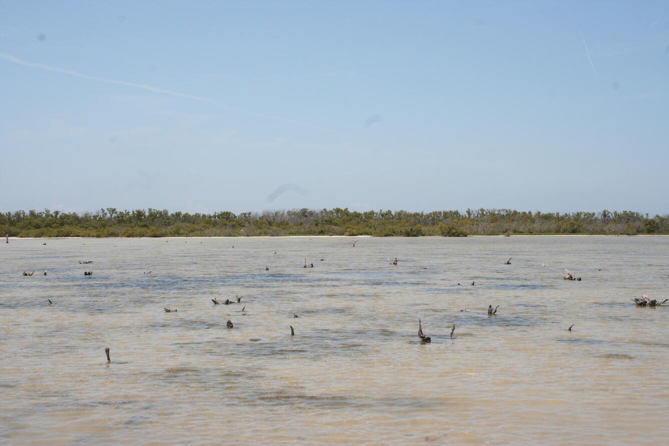
In Photo: Interior mudflat on Jim Foot Key covered with saline water, April 2019. Stumps of dead mangroves (reportedly damaged by Hurricane Donna in 1960 (Craighead, 1962)) are visible projecting from the water. Shadowed areas below the water are underwater grasses typically found in Florida Bay, now growing inside
In Photo: Interior mudflat on Jim Foot Key covered with saline water, April 2019. Stumps of dead mangroves (reportedly damaged by Hurricane Donna in 1960 (Craighead, 1962)) are visible projecting from the water. Shadowed areas below the water are underwater grasses typically found in Florida Bay, now growing inside
In Photo: Juvenile mangroves on eastern berm of Jim Foot Key, April 2019. Mangroves are intermingled with saltwort, the dominant live vegetation on the damaged berms, and standing dead mangroves. Grid is 25 cm high. The question is whether these trees will mature fast enough to protect the berm from rising sea level.
In Photo: Juvenile mangroves on eastern berm of Jim Foot Key, April 2019. Mangroves are intermingled with saltwort, the dominant live vegetation on the damaged berms, and standing dead mangroves. Grid is 25 cm high. The question is whether these trees will mature fast enough to protect the berm from rising sea level.
In Photo: Berm of Jim Foot Key about 1.5 years after Hurricane Irma. The red circle indicates the same position as shown in the April 2014 photo. The mature mangrove trees have not recovered from the storm.
In Photo: Berm of Jim Foot Key about 1.5 years after Hurricane Irma. The red circle indicates the same position as shown in the April 2014 photo. The mature mangrove trees have not recovered from the storm.
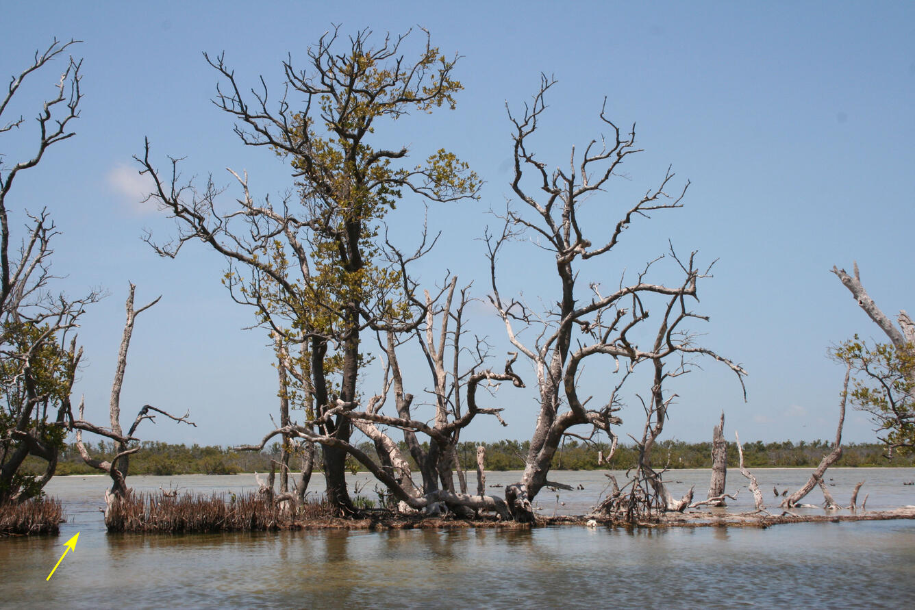
In Photo: Eastern berm of Jim Foot Key, April 2019. This photo taken from Florida Bay, looking in toward the center of the island (now covered in water). The arrow points toward a breach in the berm, first noted in 2014, but the cut has deepened significantly after Hurricane Irma, and the island interior
In Photo: Eastern berm of Jim Foot Key, April 2019. This photo taken from Florida Bay, looking in toward the center of the island (now covered in water). The arrow points toward a breach in the berm, first noted in 2014, but the cut has deepened significantly after Hurricane Irma, and the island interior
In Photo: The red circle indicates the same position as shown in the April 2014 photo. The mangroves have lost all their leaves and the berm is significantly thinner following the storm.
In Photo: The red circle indicates the same position as shown in the April 2014 photo. The mangroves have lost all their leaves and the berm is significantly thinner following the storm.
South Florida’s coast is a land of contrasts that appeals to almost everyone, whether they seek out quiet natural environments along the mangrove waterways and in the wilderness of the Everglades or vibrant international culture in Miami. Yet this paradise is threatened by a number of forces – changing climate, rising sea level, and too many people, to name a few. Florida’s past is...
Hurricane Irma made landfall in south Florida, USA, on September 10, 2017 as a category 4 storm. In January 2018, fieldwork was conducted on four previously (2014) sampled islands in Florida Bay, Everglades National Park to examine changes between 2014 and 2018. The objectives were to determine if the net impact of the storm was gain or loss of island landmass and/or elevation; observe...
Authors
G. Lynn Wingard, Sarah E. Bergstresser, Bethany Stackhouse, Miriam Jones, Marci E. Marot, Kristen Hoefke, Andre Daniels, Katherine Keller
Sediment cores from Florida Bay, Everglades National Park were examined to determine ecosystem response to relative sea-level rise (RSLR) over the Holocene. High-resolution multiproxy analysis from four sites show freshwater wetlands transitioned to mangrove environments 4–3.6 ka, followed by estuarine environments 3.4–2.8 ka, during a period of enhanced climate variability. We calculate...
Authors
Miriam Jones, G. Lynn Wingard, Bethany Stackhouse, Katherine Keller, Debra A. Willard, Marci E. Marot, Bryan D. Landacre, Christopher E. Bernhardt
Resource managers around the world are challenged to develop feasible plans for sustainable conservation and/or restoration of the lands, waters, and wildlife they administer—a challenge made greater by anticipated climate change and associated effects over the next century. Increasingly, paleoecologic and geologic archives are being used to extend the period of record of observed data...
Authors
G. Lynn Wingard, Christopher E. Bernhardt, Anna Wachnicka
Molluscs possess a number of attributes that make them an excellent source of past environmental conditions in estuaries: they are common in estuarine environments; they typically have hard shells and are usually well preserved in sediments; they are relatively easy to detect in the environment; they have limited mobility as adults; they grow by incremental addition of layers to their...
This chapter summarizes the application of various biological indicators to studying the anthropogenic and natural changes in water quality and habitats that have occurred in the coastal and estuarine areas of the Greater Everglades ecosystem.
Disruption of the natural patterns of freshwater flow into estuarine ecosystems occurred in many locations around the world beginning in the twentieth century. To effectively restore these systems, establishing a pre-alteration perspective allows managers to develop science-based restoration targets for salinity and hydrology. This paper describes a process to develop targets based on...
Authors
Frank E. Marshall, G. Lynn Wingard, Patrick A. Pitts
The coastal wetlands of southwest Florida that extend from Charlotte Harbor south to Cape Sable, contain more than 60,000 ha of mangroves and 22,177 ha of salt marsh. These coastal wetlands form a transition zone between the freshwater and marine environments of the South Florida Coastal Marine Ecosystem (SFCME). The coastal wetlands provide diverse ecosystem services that are valued by...
Shallow marine ecosystems are experiencing significant environmental alterations as a result of changing climate and increasing human activities along coasts. Intensive urbanization of the southeast Florida coast and intensification of climate change over the last few centuries changed the character of coastal ecosystems in the semi-enclosed Biscayne Bay, Florida. In order to develop...
Authors
Anna Wachnicka, Evelyn Gaiser, G. Lynn Wingard, Henry Briceno, Peter Harlem
Throughout the 20th century, the Greater Everglades Ecosystem of south Florida was greatly altered by human activities. Construction of water-control structures and facilities altered the natural hydrologic patterns of the south Florida region and consequently impacted the coastal ecosystem. Restoration of the Greater Everglades Ecosystem is guided by the Comprehensive Everglades...
A molluscan analogue dataset is presented in conjunction with a weighted-averaging technique as a tool for estimating past salinity patterns in south Florida’s estuaries and developing targets for restoration based on these reconstructions. The method, here referred to as cumulative weighted percent (CWP), was tested using modern surficial samples collected in Florida Bay from sites...
An 800-year-long environmental history of Biscayne Bay, Florida, is reconstructed from ostracod faunal and shell geochemical (oxygen, carbon isotopes, Mg/Ca ratios) studies of sediment cores from three mudbanks in the central and southern parts of the bay. Using calibrations derived from analyses of modern Biscayne and Florida Bay ostracods, palaeosalinity oscillations associated with...
Authors
Thomas M. Cronin, G. Lynn Wingard, Gary S. Dwyer, Peter K. Swart, Debra A. Willard, Jessica Albietz
The Greater Everglades Ecosystem covers much of south Florida, and the highest areas are only a few meters above sea level. Predictions of sea level rise and changes in storm intensity for the 21st century are particularly concerning to the urban population of Miami and the east coast, but also represent a challenge to Everglades National Park and Biscayne National Park resource managers. The Greater Everglades Ecosystem is undergoing a large-scale restoration effort and decisions need to be made that will affect the system for the next 20 to 30 years. Our project is designed to examine responses of the ecosystem to past sea level and climate changes to better understand coastal resiliency.
FBGC Project Members: Miriam Jones, Bethany Stackhouse, Sarah Bergstresser, Kristen Hoefke, Bryan Landacre, Christopher Bernhardt
Other USGS Project Members: Andre Daniels, Marci Marot
Collaborator: Anna Wachnicka (FIU / SFWMD)
The urban and natural landscapes of south Florida are vulnerable to flooding from sea level rise and coastal storm surges for several reasons, including low elevation, lack of topographic relief to promote drainage, and a water table that is at or very close to the land surface. With the current rate of relative sea level rise in south Florida estimated to be between 2.4-3.7 mm/year and rising, it is vital for urban planners and resource managers to understand how vulnerable the coast is to retreat and inundation.
Understanding how the natural (pre-human alteration) environment of south Florida has responded to previous changes in sea level and climate variability is an important first step to predicting what will happen over the next century. What factors make the coast more resilient? What are the most important drivers of coastal change? What is the role of mangroves and coastal vegetation in coastal resiliency? The answers to these questions can be found by studying the record preserved in sediment cores collected throughout south Florida. The layers in the cores are analyzed for physical and biological clues that tell us how the environment has changed over time. The sequence of changes seen in the cores provides information about the factors that drive these changes, such as fluctuations in storm frequency or strength, increased or decreased sea level, or loss of key species such as mangroves and sea grass beds.
A few months after Hurricane Irma hit Florida, a team from the Florence Bascom Geoscience Center conducted field work to determine what effects the storm had on islands in Florida Bay. On Bob Allen island approximately 5.5 cm of mud (the upper layer shown here) were deposited by the storm. The distinctive blue-green algal mat below the mud (visible where the block of storm deposited mud has been removed) made it easy to tell the thickness of the storm deposition.
An important part of interpreting past environmental history in cores is understanding how physical and biological processes interact in the present and what are the ecological requirements of key species. By studying the present, we are better able to interpret the past record in the cores, which in turn can give us insights into what the future will look like. An especially important factor in coastal change in south Florida are hurricanes, and since 1888 twenty-one major hurricanes (category 3 or above on the Saffir-Simpson scale) have made landfall within an approximately 100-mile radius of Florida Bay, where many of our cores are located. Detailed scientific investigations have been conducted following a few of these storms, and this information provides us with a means to look at the decadal-scale impacts of storms on the coastline. In September 2017, Hurricane Irma passed just west of our field sites, giving us a first-hand look at the immediate impact of storms on the mangrove coastline. By combining our observations of ongoing changes in the coastline with the 3000 to 5000 year record preserved in our cores, we are providing resource managers and urban planners with a better understanding of the natural processes of coastal change, the rates of response of the system to these changes, and what factors contribute to coastal resiliency.
The Greater Everglades Ecosystem, which includes Everglades National Park and Biscayne National Park, experienced significant alterations in the 20th century with the construction of canals to divert water, water management practices, growth of agriculture, and the rapidly expanding urban population of Miami and south Florida. In the 1990s a federal, state, and local effort to restore the Greater...
Determining Target Salinity Values for Restoration of the Estuaries of the Greater Everglades
The Greater Everglades Ecosystem, which includes Everglades National Park and Biscayne National Park, experienced significant alterations in the 20th century with the construction of canals to divert water, water management practices, growth of agriculture, and the rapidly expanding urban population of Miami and south Florida. In the 1990s a federal, state, and local effort to restore the Greater...
The 2008 - Present Ecosystem History of South Florida's Estuaries Database contains listings of all sites (modern and core) and modern monitoring site survey information (water chemistry, floral and faunal data, etc.). Three general types of data are contained within this database: 1) Modern Field Data (2008-present), 2) Master list of location information on all modern sites, and 3)...
In Photo: Interior mudflat on Jim Foot Key covered with saline water, April 2019. Stumps of dead mangroves (reportedly damaged by Hurricane Donna in 1960 (Craighead, 1962)) are visible projecting from the water. Shadowed areas below the water are underwater grasses typically found in Florida Bay, now growing inside
In Photo: Interior mudflat on Jim Foot Key covered with saline water, April 2019. Stumps of dead mangroves (reportedly damaged by Hurricane Donna in 1960 (Craighead, 1962)) are visible projecting from the water. Shadowed areas below the water are underwater grasses typically found in Florida Bay, now growing inside
In Photo: Juvenile mangroves on eastern berm of Jim Foot Key, April 2019. Mangroves are intermingled with saltwort, the dominant live vegetation on the damaged berms, and standing dead mangroves. Grid is 25 cm high. The question is whether these trees will mature fast enough to protect the berm from rising sea level.
In Photo: Juvenile mangroves on eastern berm of Jim Foot Key, April 2019. Mangroves are intermingled with saltwort, the dominant live vegetation on the damaged berms, and standing dead mangroves. Grid is 25 cm high. The question is whether these trees will mature fast enough to protect the berm from rising sea level.
In Photo: Berm of Jim Foot Key about 1.5 years after Hurricane Irma. The red circle indicates the same position as shown in the April 2014 photo. The mature mangrove trees have not recovered from the storm.
In Photo: Berm of Jim Foot Key about 1.5 years after Hurricane Irma. The red circle indicates the same position as shown in the April 2014 photo. The mature mangrove trees have not recovered from the storm.
In Photo: Eastern berm of Jim Foot Key, April 2019. This photo taken from Florida Bay, looking in toward the center of the island (now covered in water). The arrow points toward a breach in the berm, first noted in 2014, but the cut has deepened significantly after Hurricane Irma, and the island interior
In Photo: Eastern berm of Jim Foot Key, April 2019. This photo taken from Florida Bay, looking in toward the center of the island (now covered in water). The arrow points toward a breach in the berm, first noted in 2014, but the cut has deepened significantly after Hurricane Irma, and the island interior
In Photo: The red circle indicates the same position as shown in the April 2014 photo. The mangroves have lost all their leaves and the berm is significantly thinner following the storm.
In Photo: The red circle indicates the same position as shown in the April 2014 photo. The mangroves have lost all their leaves and the berm is significantly thinner following the storm.
South Florida’s coast is a land of contrasts that appeals to almost everyone, whether they seek out quiet natural environments along the mangrove waterways and in the wilderness of the Everglades or vibrant international culture in Miami. Yet this paradise is threatened by a number of forces – changing climate, rising sea level, and too many people, to name a few. Florida’s past is...
Hurricane Irma made landfall in south Florida, USA, on September 10, 2017 as a category 4 storm. In January 2018, fieldwork was conducted on four previously (2014) sampled islands in Florida Bay, Everglades National Park to examine changes between 2014 and 2018. The objectives were to determine if the net impact of the storm was gain or loss of island landmass and/or elevation; observe...
Authors
G. Lynn Wingard, Sarah E. Bergstresser, Bethany Stackhouse, Miriam Jones, Marci E. Marot, Kristen Hoefke, Andre Daniels, Katherine Keller
Sediment cores from Florida Bay, Everglades National Park were examined to determine ecosystem response to relative sea-level rise (RSLR) over the Holocene. High-resolution multiproxy analysis from four sites show freshwater wetlands transitioned to mangrove environments 4–3.6 ka, followed by estuarine environments 3.4–2.8 ka, during a period of enhanced climate variability. We calculate...
Authors
Miriam Jones, G. Lynn Wingard, Bethany Stackhouse, Katherine Keller, Debra A. Willard, Marci E. Marot, Bryan D. Landacre, Christopher E. Bernhardt
Resource managers around the world are challenged to develop feasible plans for sustainable conservation and/or restoration of the lands, waters, and wildlife they administer—a challenge made greater by anticipated climate change and associated effects over the next century. Increasingly, paleoecologic and geologic archives are being used to extend the period of record of observed data...
Authors
G. Lynn Wingard, Christopher E. Bernhardt, Anna Wachnicka
Molluscs possess a number of attributes that make them an excellent source of past environmental conditions in estuaries: they are common in estuarine environments; they typically have hard shells and are usually well preserved in sediments; they are relatively easy to detect in the environment; they have limited mobility as adults; they grow by incremental addition of layers to their...
This chapter summarizes the application of various biological indicators to studying the anthropogenic and natural changes in water quality and habitats that have occurred in the coastal and estuarine areas of the Greater Everglades ecosystem.
Disruption of the natural patterns of freshwater flow into estuarine ecosystems occurred in many locations around the world beginning in the twentieth century. To effectively restore these systems, establishing a pre-alteration perspective allows managers to develop science-based restoration targets for salinity and hydrology. This paper describes a process to develop targets based on...
Authors
Frank E. Marshall, G. Lynn Wingard, Patrick A. Pitts
The coastal wetlands of southwest Florida that extend from Charlotte Harbor south to Cape Sable, contain more than 60,000 ha of mangroves and 22,177 ha of salt marsh. These coastal wetlands form a transition zone between the freshwater and marine environments of the South Florida Coastal Marine Ecosystem (SFCME). The coastal wetlands provide diverse ecosystem services that are valued by...
Shallow marine ecosystems are experiencing significant environmental alterations as a result of changing climate and increasing human activities along coasts. Intensive urbanization of the southeast Florida coast and intensification of climate change over the last few centuries changed the character of coastal ecosystems in the semi-enclosed Biscayne Bay, Florida. In order to develop...
Authors
Anna Wachnicka, Evelyn Gaiser, G. Lynn Wingard, Henry Briceno, Peter Harlem
Throughout the 20th century, the Greater Everglades Ecosystem of south Florida was greatly altered by human activities. Construction of water-control structures and facilities altered the natural hydrologic patterns of the south Florida region and consequently impacted the coastal ecosystem. Restoration of the Greater Everglades Ecosystem is guided by the Comprehensive Everglades...
A molluscan analogue dataset is presented in conjunction with a weighted-averaging technique as a tool for estimating past salinity patterns in south Florida’s estuaries and developing targets for restoration based on these reconstructions. The method, here referred to as cumulative weighted percent (CWP), was tested using modern surficial samples collected in Florida Bay from sites...
An 800-year-long environmental history of Biscayne Bay, Florida, is reconstructed from ostracod faunal and shell geochemical (oxygen, carbon isotopes, Mg/Ca ratios) studies of sediment cores from three mudbanks in the central and southern parts of the bay. Using calibrations derived from analyses of modern Biscayne and Florida Bay ostracods, palaeosalinity oscillations associated with...
Authors
Thomas M. Cronin, G. Lynn Wingard, Gary S. Dwyer, Peter K. Swart, Debra A. Willard, Jessica Albietz


")


