
A zoomed in image of Annual NLCD Land Cover in 2023 for Silverdale, Washington. Annual NLCD Land Cover science product represents the most likely thematic land cover type of the Anderson Level II classes. Learn more about Annual NLCD.
Where can I find land cover data for the U.S.?
Information on land cover data from the National Land Cover Database (NLCD) is on the Multi-Resolution Land Characteristics (MRLC) website. The MRLC website serves several different vintages (dates) of the National Land Cover Database beginning with the 2001 data.
Related

Does Landsat Level-1 data processing include atmospheric correction? Does Landsat Level-1 data processing include atmospheric correction?
Landsat Level-1 data are not corrected for atmospheric conditions; however, Landsat Science Products are atmospherically corrected. Learn more: L andsat Level-1 data Landsat U.S. Analysis Ready Data Landsat Level-2 and Level-3 Science Products Landsat Data Access

What are Landsat Collections? What are Landsat Collections?
In 2016, the USGS reorganized the Landsat archive into a tiered collection. This structure ensures that Landsat Level-1 products provide a consistent archive of known data quality to support time-series analyses and data “stacking”, while controlling continuous improvement of the archive and access to all data as they are acquired. Learn more: Landsat Collections Landsat Data Access

How do I download The National Map data products? How do I download The National Map data products?
Download or access The National Map data products via several applications and websites: The National Map Download Client – The primary site for data downloads. See the training videos (lessons 4a-4d) or click the Help link at the top of the Downloader for detailed instructions. LidarExplorer – Lidar Point Cloud data only. See where lidar is available, get a list of downloadable products, and...

Annual NLCD Land Cover 2023
A zoomed in image of Annual NLCD Land Cover in 2023 for Silverdale, Washington. Annual NLCD Land Cover science product represents the most likely thematic land cover type of the Anderson Level II classes. Learn more about Annual NLCD.

Annual NLCD Land Cover 1985
Zoomed in image of Annual NLCD Land Cover in 1985. Annual NLCD Land Cover science product represents the most likely thematic land cover type of the Anderson Level II classes.
Zoomed in image of Annual NLCD Land Cover in 1985. Annual NLCD Land Cover science product represents the most likely thematic land cover type of the Anderson Level II classes.

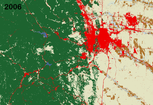
Land cover change in the northern Dallas-Fort Worth area from 1985-2023 as shown by Annual NLCD Collection 1.0
Land cover change in the northern Dallas-Fort Worth area from 1985-2023 as shown by Annual NLCD Collection 1.0An animation of images from the Annual National Land Cover Database (NLCD) for every year from 1985 through 2023 showing land cover changes and the progression of growth of urban areas (in red) in the northern Dallas-Fort Worth, Texas, metropolitan area.

Eyes on Earth Episode 13 – Land Use
Summary: Scientists at EROS use tools like Landsat to produce land cover maps, which tell us if landscapes are rural or urban, cropped or forested, wetland or shrubland. Those maps help scientists at EROS and around the U.S. study the impact of changes in land use on not just landscapes, but on ecosystems, patterns of resource use, wildlife habitat, and much more.
Summary: Scientists at EROS use tools like Landsat to produce land cover maps, which tell us if landscapes are rural or urban, cropped or forested, wetland or shrubland. Those maps help scientists at EROS and around the U.S. study the impact of changes in land use on not just landscapes, but on ecosystems, patterns of resource use, wildlife habitat, and much more.

Eyes on Earth Episode 8 – Assessing America’s Cropland
Eyes on Earth Episode 8 – Assessing America’s CroplandEvery year, the USDA’s National Agricultural Statistics Service (NASS) uses data from satellites like Landsat to estimate crop types and crop yields in the United States. The result is the Cropland Data Layer (CDL), which offers an annual look at more than 100 crop categories across the country.

Eyes on Earth - Episode 3 - The National Land Cover Database
Eyes on Earth - Episode 3 - The National Land Cover DatabaseSorting Landsat data into an accurate and reliable record of land cover in the United States is one of the most important jobs at EROS. This episode of Eyes on Earth explores the what, how, and why of the National Land Cover Database (NLCD).
Land Change in the Black Hills - LCMAP
Animation of land cover change in the Black Hills, created using Land Change Monitoring, Assessment, and Projection data from the USGS Earth Resources Observation and Science (EROS) Center.
Animation of land cover change in the Black Hills, created using Land Change Monitoring, Assessment, and Projection data from the USGS Earth Resources Observation and Science (EROS) Center.

Chester County, Pennsylvania Land Change Animation
Chester County, Pennsylvania Land Change AnimationChester County, Pennsylvania has always been close-in hinterland of the city of Philadelphia. As the metropolitan area expanded, Chester County became one of the suburban frontiers of Philadelphia, with developed land cover concentrated along transportation corridors that were first railroad lines and later U.S. and state highways, such as U.S.
Related
Does Landsat Level-1 data processing include atmospheric correction? Does Landsat Level-1 data processing include atmospheric correction?
Landsat Level-1 data are not corrected for atmospheric conditions; however, Landsat Science Products are atmospherically corrected. Learn more: L andsat Level-1 data Landsat U.S. Analysis Ready Data Landsat Level-2 and Level-3 Science Products Landsat Data Access
What are Landsat Collections? What are Landsat Collections?
In 2016, the USGS reorganized the Landsat archive into a tiered collection. This structure ensures that Landsat Level-1 products provide a consistent archive of known data quality to support time-series analyses and data “stacking”, while controlling continuous improvement of the archive and access to all data as they are acquired. Learn more: Landsat Collections Landsat Data Access
How do I download The National Map data products? How do I download The National Map data products?
Download or access The National Map data products via several applications and websites: The National Map Download Client – The primary site for data downloads. See the training videos (lessons 4a-4d) or click the Help link at the top of the Downloader for detailed instructions. LidarExplorer – Lidar Point Cloud data only. See where lidar is available, get a list of downloadable products, and...
Annual NLCD Land Cover 2023
A zoomed in image of Annual NLCD Land Cover in 2023 for Silverdale, Washington. Annual NLCD Land Cover science product represents the most likely thematic land cover type of the Anderson Level II classes. Learn more about Annual NLCD.
A zoomed in image of Annual NLCD Land Cover in 2023 for Silverdale, Washington. Annual NLCD Land Cover science product represents the most likely thematic land cover type of the Anderson Level II classes. Learn more about Annual NLCD.
Annual NLCD Land Cover 1985
Zoomed in image of Annual NLCD Land Cover in 1985. Annual NLCD Land Cover science product represents the most likely thematic land cover type of the Anderson Level II classes.
Zoomed in image of Annual NLCD Land Cover in 1985. Annual NLCD Land Cover science product represents the most likely thematic land cover type of the Anderson Level II classes.
Land cover change in the northern Dallas-Fort Worth area from 1985-2023 as shown by Annual NLCD Collection 1.0
Land cover change in the northern Dallas-Fort Worth area from 1985-2023 as shown by Annual NLCD Collection 1.0An animation of images from the Annual National Land Cover Database (NLCD) for every year from 1985 through 2023 showing land cover changes and the progression of growth of urban areas (in red) in the northern Dallas-Fort Worth, Texas, metropolitan area.
Eyes on Earth Episode 13 – Land Use
Summary: Scientists at EROS use tools like Landsat to produce land cover maps, which tell us if landscapes are rural or urban, cropped or forested, wetland or shrubland. Those maps help scientists at EROS and around the U.S. study the impact of changes in land use on not just landscapes, but on ecosystems, patterns of resource use, wildlife habitat, and much more.
Summary: Scientists at EROS use tools like Landsat to produce land cover maps, which tell us if landscapes are rural or urban, cropped or forested, wetland or shrubland. Those maps help scientists at EROS and around the U.S. study the impact of changes in land use on not just landscapes, but on ecosystems, patterns of resource use, wildlife habitat, and much more.
Eyes on Earth Episode 8 – Assessing America’s Cropland
Eyes on Earth Episode 8 – Assessing America’s CroplandEvery year, the USDA’s National Agricultural Statistics Service (NASS) uses data from satellites like Landsat to estimate crop types and crop yields in the United States. The result is the Cropland Data Layer (CDL), which offers an annual look at more than 100 crop categories across the country.
Eyes on Earth - Episode 3 - The National Land Cover Database
Eyes on Earth - Episode 3 - The National Land Cover DatabaseSorting Landsat data into an accurate and reliable record of land cover in the United States is one of the most important jobs at EROS. This episode of Eyes on Earth explores the what, how, and why of the National Land Cover Database (NLCD).
Land Change in the Black Hills - LCMAP
Animation of land cover change in the Black Hills, created using Land Change Monitoring, Assessment, and Projection data from the USGS Earth Resources Observation and Science (EROS) Center.
Animation of land cover change in the Black Hills, created using Land Change Monitoring, Assessment, and Projection data from the USGS Earth Resources Observation and Science (EROS) Center.
Chester County, Pennsylvania Land Change Animation
Chester County, Pennsylvania Land Change AnimationChester County, Pennsylvania has always been close-in hinterland of the city of Philadelphia. As the metropolitan area expanded, Chester County became one of the suburban frontiers of Philadelphia, with developed land cover concentrated along transportation corridors that were first railroad lines and later U.S. and state highways, such as U.S.
Updated Date: December 22, 2025