
Planting butterfly-friendly plants in your yard or balcony (especially monarch favorites like native milkweeds), reducing harmful chemical use in your lawns and gardens, and “leaving the leaves” in the fall to protect overwintering pupae can all promote butterfly populations in your area!
Images
Explore photos, graphics, and illustrations related to projects from across the CASC Network. And be sure to check out our Climate Illustrations page, featuring free-to-download illustrations that help describe tricky climate concepts and explain how climate change affects the world around us.
Filter Total Items: 638
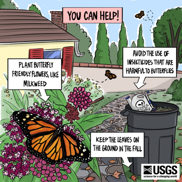
How to Help Native Pollinators
Planting butterfly-friendly plants in your yard or balcony (especially monarch favorites like native milkweeds), reducing harmful chemical use in your lawns and gardens, and “leaving the leaves” in the fall to protect overwintering pupae can all promote butterfly populations in your area!

How Climate Change Affects the Life Cycle of Monarch Butterflies
How Climate Change Affects the Life Cycle of Monarch ButterfliesDrawing showing climate change impacts to each life cycle stage of monarchs: 1) Butterflies lay fewer eggs in wetter conditions, 2) Warmer temperatures reduce milkweed growth, leaving caterpillars hungry, 3) Erratic winters freeze overwintering pupae, 4) Shifting seasons disrupt migrations.

Abundant Biocrust and Phlox in Sagebrush Landscape
Abundant Biocrust and Phlox in Sagebrush LandscapeIn this sagebrush community, there are intact biological soil crusts that are composed of cyanobacteria, lichens and mosses. Phlox sp. are growing abundantly on these biocrust communities.
Abundant Biocrust and Phlox in Sagebrush Landscape
Abundant Biocrust and Phlox in Sagebrush LandscapeIn this sagebrush community, there are intact biological soil crusts that are composed of cyanobacteria, lichens and mosses. Phlox sp. are growing abundantly on these biocrust communities.
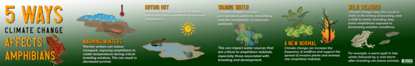
5 Ways Climate Change Affects Amphibians
An infographic detailing five ways climate change affects amphibians.
Created by Courtenay Duzet & Louise Johansson, USGS, May 2023.
An infographic detailing five ways climate change affects amphibians.
Created by Courtenay Duzet & Louise Johansson, USGS, May 2023.

North and South Bubble Mountain at Jordan Pond in Acadia National Park
North and South Bubble Mountain at Jordan Pond in Acadia National ParkA view of the North and South Bubble Mountains in front of Jordan Pond in Acadia National Park.
North and South Bubble Mountain at Jordan Pond in Acadia National Park
North and South Bubble Mountain at Jordan Pond in Acadia National ParkA view of the North and South Bubble Mountains in front of Jordan Pond in Acadia National Park.

Rock Piles and Agave Plants at Mission Garden
Rock pile trincheras with agave plants at Mission Garden, a living agricultural museum of Sonoran Desert-adapted heritage trees, traditional local heirloom crops and edible native plants in Tucson, Arizona.
Rock pile trincheras with agave plants at Mission Garden, a living agricultural museum of Sonoran Desert-adapted heritage trees, traditional local heirloom crops and edible native plants in Tucson, Arizona.

Loʻipūnāwai on the southern coast of Moloka‘i, Hawaiʻi
Loʻipūnāwai on the southern coast of Moloka‘i, HawaiʻiKaupapaloʻi o Kaʻamola

A view of the East River Valley from the shoulder of Gothic Mountain, Colorado
A view of the East River Valley from the shoulder of Gothic Mountain, ColoradoA view of the East River Valley from the shoulder of Gothic Mountain, Colorado
A view of the East River Valley from the shoulder of Gothic Mountain, Colorado
A view of the East River Valley from the shoulder of Gothic Mountain, ColoradoA view of the East River Valley from the shoulder of Gothic Mountain, Colorado
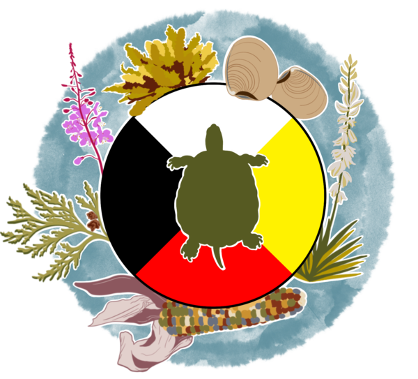
Artwork for the Webinar Series: Incorporating Indigenous Knowledges into Federal Research and Management
Artwork for the Webinar Series: Incorporating Indigenous Knowledges into Federal Research and ManagementThis artwork was created to represent the National Climate Adaptation Science Center webinar series "Incorporating Indigenous Knowledges into Federal Research and Management."

Map of Southwest Region Boundary
Map of Southwest Region generated from ArcGIS Pro using public domain layers from AGOL at 1:20M scale.
Map of Southwest Region generated from ArcGIS Pro using public domain layers from AGOL at 1:20M scale.

Climate Change Refugia
Climate Change Refugia (noun): Areas buffered from climate change that enable the continued persistence of plants and animals.
Climate Change Refugia (noun): Areas buffered from climate change that enable the continued persistence of plants and animals.
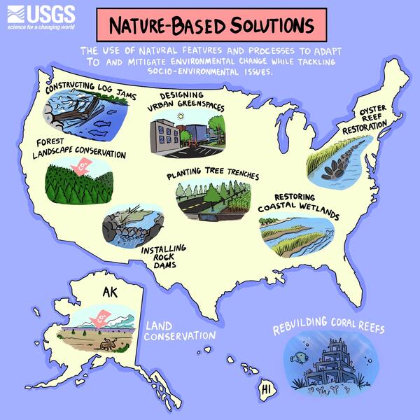
Nature-Based Solutions
Investing in nature isn’t limited to our public lands, it can be in your own backyard! Nature-based solutions are a way to solve problems by using nature as tool. They can bring the outdoors to you to make your communities safer, healthier, and greener. It’s a win-win!
Nature-based solutions can look like:
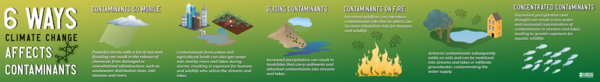
6 Ways Climate Change Affects Contaminants
An infographic detailing six ways climate change affects the spread of contaminants.
Created by Courtenay Duzet, USGS, March 2023.
An infographic detailing six ways climate change affects the spread of contaminants.
Created by Courtenay Duzet, USGS, March 2023.

A close up of Sonoran Desert native wildflowers/forbs, including California poppy, lupines, and purple owl's clover
A close up of Sonoran Desert native wildflowers/forbs, including California poppy, lupines, and purple owl's cloverClose up of Sonoran Desert flowers, including California poppy, lupines, and purple owl's clover. Photo by Laura Shriver.

Aerial image of rocky shoreline along Central California coast
Aerial image of rocky shoreline along Central California coastAerial image of rocky shoreline at Garrapata State Park, along the Central California coast.
Aerial image of rocky shoreline along Central California coast
Aerial image of rocky shoreline along Central California coastAerial image of rocky shoreline at Garrapata State Park, along the Central California coast.

Climate Connections: Avian Malaria & Hawaiian Forest Birds
Climate Connections: Avian Malaria & Hawaiian Forest BirdsAn overview of the effects of climate change on the spread of avian malaria and its subsequent impacts on Hawaiian forest birds.
Climate Connections: Avian Malaria & Hawaiian Forest Birds
Climate Connections: Avian Malaria & Hawaiian Forest BirdsAn overview of the effects of climate change on the spread of avian malaria and its subsequent impacts on Hawaiian forest birds.
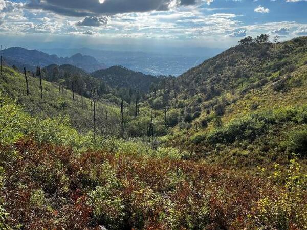
orovalley.jpg
Oro Valley, Santa Catalina Mountains, AZ, USA; Photo Credit: Jose Iniguez (USFS)
Oro Valley, Santa Catalina Mountains, AZ, USA; Photo Credit: Jose Iniguez (USFS)