The soil core (top) was collected from Bass Creek, Yarmouth, MA, which was restored in 2008. From this soil core, scientists recreated the elevation of the marsh surface over the past 100 years, as well as how quickly elevation changed.
Meagan J. Eagle , PhD
My research lies at the interface of land and sea and is used to build new tools to address coastal hazards. This dynamic region is experiencing rapid change, with new pressures from rising temperatures and sea level adding to those already wrought by the impacts of coastal development.
I utilize a suite of geochemical tools, including naturally occurring radioisotopes in the Uranium-Thorium decay series, to understand both the magnitude and rate of change within coastal ecosystems. In particular, I am interested in how salt marshes have responded to a century of accelerating sea level rise, with a focus on their ability to store carbon and dynamically build elevation. I combine historical ecosystem information, gleaned from analysis of salt marsh peat, with modern environmental drivers to constrain future ecosystem responses.
I studied geology at Stanford University (BS/MS) and received a PhD in Chemical Oceanography from the Massachusetts Institute of Technology and Woods Hole Oceanographic Institution Joint Program. There I studied groundwater discharge and associated chemical fluxes. Between going to school, I did a Fulbright Fellowship in Mauritius and worked at Woods Hole Oceanographic Institution. I came to the Woods Hole Coastal and Marine Science Center of the US Geological Survey in 2013 and have worked on coastal wetland and groundwater projects across the US.
Science and Products
Quantifying Restoration Impacts of Wetland Ecosystem Health and Carbon Export
Sea level Rise and Carbon Cycle Processes in Managed Coastal Wetlands
Environmental Geochemistry
Concentrations of Per- and Polyfluoroalkyl Substances (PFAS) in Lake-Bottom Sediments of Ashumet Pond on Cape Cod, Massachusetts, 2020 (ver. 2.0, February 2024)
Nearshore groundwater seepage and geochemical data measured in 2015 at Guinea Creek, Rehoboth Bay, Delaware
Carbon dioxide and methane fluxes with supporting environmental data from coastal wetlands across Cape Cod, Massachusetts (ver 2.0, June 2022)
Saline tidal wetlands are important sites of carbon sequestration and produce negligible methane (CH4) emissions due to regular inundation with sulfate-rich seawater. Yet, widespread management of coastal hydrology has restricted vast areas of coastal wetlands to tidal exchange. These ecosystems often undergo impoundment and freshening, which in turn cause vegetation shifts like invasion by Phragm
Continuous Water Level, Salinity, and Temperature Data from Coastal Wetland Monitoring Wells, Cape Cod, Massachusetts (ver. 2.0, August 2022)
Static chamber gas fluxes and carbon and nitrogen isotope content of age-dated sediment cores from a Phragmites wetland in Sage Lot Pond, Massachusetts, 2013-2015
Collection, analysis, and age-dating of sediment cores from Herring River wetlands and other nearby wetlands in Wellfleet, Massachusetts, 2015-17
Collection, Analysis, and Age-Dating of Sediment Cores from Salt Marshes, Rhode Island, 2016
Collection, analysis, and age-dating of sediment cores from natural and restored salt marshes on Cape Cod, Massachusetts, 2015-16
Collection, analysis, and age-dating of sediment cores from mangrove and salt marsh ecosystems in Tampa Bay, Florida, 2015
Collection, analysis, and age-dating of sediment cores from mangrove wetlands in San Juan Bay Estuary, Puerto Rico, 2016
Geochemical data supporting investigation of solute and particle cycling and fluxes from two tidal wetlands on the south shore of Cape Cod, Massachusetts, 2012-19 (ver. 2.0, October 2022)
Collection, analysis, and age-dating of sediment cores from a salt marsh platform and ponds, Rowley, Massachusetts, 2014-15
The soil core (top) was collected from Bass Creek, Yarmouth, MA, which was restored in 2008. From this soil core, scientists recreated the elevation of the marsh surface over the past 100 years, as well as how quickly elevation changed.
Aerial view of a gas flux tower in Great Barnstable Marsh in Barnstable, Massachusetts.
Scientists collect soil cores in coastal wetland by removing a section of peat, the organic-rich material that makes up salt marshes. After the soil is removed, water quickly fills in the void. This water-logged environment underground is devoid of oxygen and is an important reason that salt marsh peat preserves a record of historical changes.
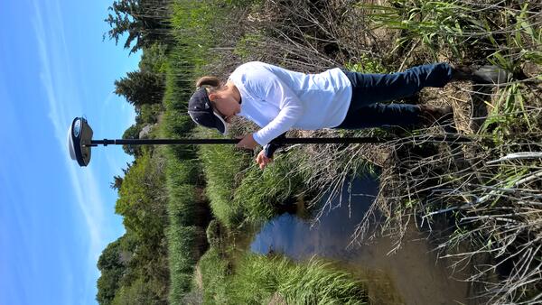
Meagan Eagle, USGS Research Scientist, collecting elevation points in Quivett Creek, Brewster, MA
linkMeagan Eagle, Research Scientists at the U.S. Geological Survey, collects an elevation point along the edge of Quivett Creek in Brewster, MA. This salt marsh was restored in 2005 by replacing a narrow culvert to allow full tidal flow once again.
Salt marsh grass grows in the restored marsh at Bass Creek, Yarmouth, MA.
Two USGS scientists measure elevation at Bass Creek salt marsh, Yarmouth, MA.
Meagan Eagle's publications
Unlearning Racism in Geoscience (URGE): Summary of U.S. Geological Survey URGE pod deliverables
The Coastal Carbon Library and Atlas: Open source soil data and tools supporting blue carbon research and policy
Carbonate chemistry and carbon sequestration driven by inorganic carbon outwelling from mangroves and saltmarshes
Practical guide to measuring wetland carbon pools and fluxes
Wetlands cover a small portion of the world, but have disproportionate influence on global carbon (C) sequestration, carbon dioxide and methane emissions, and aquatic C fluxes. However, the underlying biogeochemical processes that affect wetland C pools and fluxes are complex and dynamic, making measurements of wetland C challenging. Over decades of research, many observational, experimental, and
Mapping methane reduction potential of tidal wetland restoration in the United States
High-frequency variability of carbon dioxide fluxes in tidal water over a temperate salt marsh
The blue carbon reservoirs from Maine to Long Island, NY
Forecasting sea level rise-driven inundation in diked and tidally restricted coastal lowlands
Peat decomposition and erosion contribute to pond deepening in a temperate salt marsh
Mechanisms and magnitude of dissolved silica release from a New England salt marsh
CO2 uptake offsets other greenhouse gas emissions from salt marshes with chronic nitrogen loading
Soil carbon consequences of historic hydrologic impairment and recent restoration in coastal wetlands
Science and Products
Quantifying Restoration Impacts of Wetland Ecosystem Health and Carbon Export
Sea level Rise and Carbon Cycle Processes in Managed Coastal Wetlands
Environmental Geochemistry
Concentrations of Per- and Polyfluoroalkyl Substances (PFAS) in Lake-Bottom Sediments of Ashumet Pond on Cape Cod, Massachusetts, 2020 (ver. 2.0, February 2024)
Nearshore groundwater seepage and geochemical data measured in 2015 at Guinea Creek, Rehoboth Bay, Delaware
Carbon dioxide and methane fluxes with supporting environmental data from coastal wetlands across Cape Cod, Massachusetts (ver 2.0, June 2022)
Saline tidal wetlands are important sites of carbon sequestration and produce negligible methane (CH4) emissions due to regular inundation with sulfate-rich seawater. Yet, widespread management of coastal hydrology has restricted vast areas of coastal wetlands to tidal exchange. These ecosystems often undergo impoundment and freshening, which in turn cause vegetation shifts like invasion by Phragm
Continuous Water Level, Salinity, and Temperature Data from Coastal Wetland Monitoring Wells, Cape Cod, Massachusetts (ver. 2.0, August 2022)
Static chamber gas fluxes and carbon and nitrogen isotope content of age-dated sediment cores from a Phragmites wetland in Sage Lot Pond, Massachusetts, 2013-2015
Collection, analysis, and age-dating of sediment cores from Herring River wetlands and other nearby wetlands in Wellfleet, Massachusetts, 2015-17
Collection, Analysis, and Age-Dating of Sediment Cores from Salt Marshes, Rhode Island, 2016
Collection, analysis, and age-dating of sediment cores from natural and restored salt marshes on Cape Cod, Massachusetts, 2015-16
Collection, analysis, and age-dating of sediment cores from mangrove and salt marsh ecosystems in Tampa Bay, Florida, 2015
Collection, analysis, and age-dating of sediment cores from mangrove wetlands in San Juan Bay Estuary, Puerto Rico, 2016
Geochemical data supporting investigation of solute and particle cycling and fluxes from two tidal wetlands on the south shore of Cape Cod, Massachusetts, 2012-19 (ver. 2.0, October 2022)
Collection, analysis, and age-dating of sediment cores from a salt marsh platform and ponds, Rowley, Massachusetts, 2014-15
The soil core (top) was collected from Bass Creek, Yarmouth, MA, which was restored in 2008. From this soil core, scientists recreated the elevation of the marsh surface over the past 100 years, as well as how quickly elevation changed.
Aerial view of a gas flux tower in Great Barnstable Marsh in Barnstable, Massachusetts.
Scientists collect soil cores in coastal wetland by removing a section of peat, the organic-rich material that makes up salt marshes. After the soil is removed, water quickly fills in the void. This water-logged environment underground is devoid of oxygen and is an important reason that salt marsh peat preserves a record of historical changes.
Meagan Eagle, USGS Research Scientist, collecting elevation points in Quivett Creek, Brewster, MA
linkMeagan Eagle, Research Scientists at the U.S. Geological Survey, collects an elevation point along the edge of Quivett Creek in Brewster, MA. This salt marsh was restored in 2005 by replacing a narrow culvert to allow full tidal flow once again.
Meagan Eagle, USGS Research Scientist, collecting elevation points in Quivett Creek, Brewster, MA
linkMeagan Eagle, Research Scientists at the U.S. Geological Survey, collects an elevation point along the edge of Quivett Creek in Brewster, MA. This salt marsh was restored in 2005 by replacing a narrow culvert to allow full tidal flow once again.
Salt marsh grass grows in the restored marsh at Bass Creek, Yarmouth, MA.
Two USGS scientists measure elevation at Bass Creek salt marsh, Yarmouth, MA.
Meagan Eagle's publications
Unlearning Racism in Geoscience (URGE): Summary of U.S. Geological Survey URGE pod deliverables
The Coastal Carbon Library and Atlas: Open source soil data and tools supporting blue carbon research and policy
Carbonate chemistry and carbon sequestration driven by inorganic carbon outwelling from mangroves and saltmarshes
Practical guide to measuring wetland carbon pools and fluxes
Wetlands cover a small portion of the world, but have disproportionate influence on global carbon (C) sequestration, carbon dioxide and methane emissions, and aquatic C fluxes. However, the underlying biogeochemical processes that affect wetland C pools and fluxes are complex and dynamic, making measurements of wetland C challenging. Over decades of research, many observational, experimental, and