



The first National Land Cover Dataset (NLCD), based on Landsat 5 data, is completed and available for distribution in 2000.
Images
Core Science Systems images.
Filter Total Items: 685
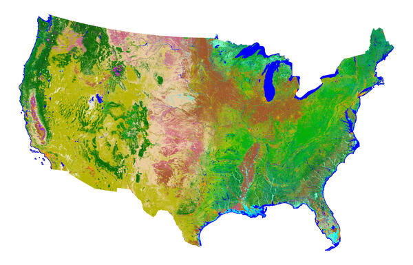
NLCD 1992
The first National Land Cover Dataset (NLCD), based on Landsat 5 data, is completed and available for distribution in 2000.
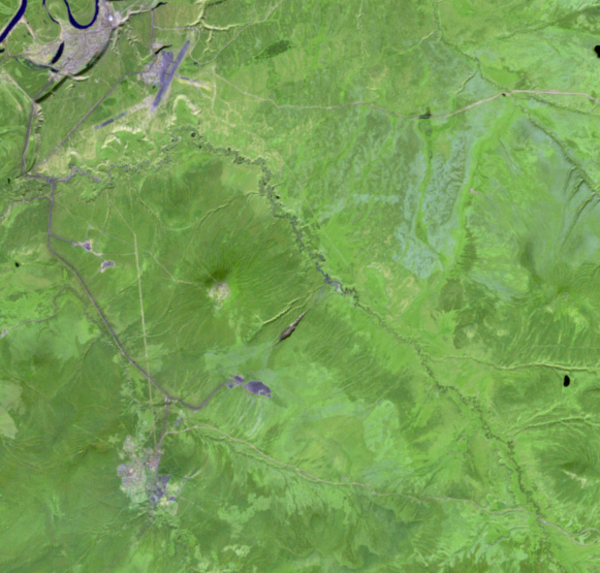
1991 Landsat Image of the Batagaika Crater
Sometimes described as resembling a stingray or a tadpole, the Batagaika Crater is a widening chasm in Siberia and the world’s largest permafrost crater.
Sometimes described as resembling a stingray or a tadpole, the Batagaika Crater is a widening chasm in Siberia and the world’s largest permafrost crater.

EROS Employee Holding Fish from Pond
EROS Employee Aaron Neugebauer holding fish from the EROS pond.
EROS Employee Aaron Neugebauer holding fish from the EROS pond.

1985 China image
This Landsat satellite image was created during a group effort to promote remote sensing science in 1985.
This Landsat satellite image was created during a group effort to promote remote sensing science in 1985.

1985 Public Law 98-365 The Land Remote Sensing Commercialization Act
1985 Public Law 98-365 The Land Remote Sensing Commercialization ActScreenshot of the 1985 Public Law 98-365 The Land Remote Sensing Commercialization Act Memo
1985 Public Law 98-365 The Land Remote Sensing Commercialization Act
1985 Public Law 98-365 The Land Remote Sensing Commercialization ActScreenshot of the 1985 Public Law 98-365 The Land Remote Sensing Commercialization Act Memo

Landsat 4 First Light Image over western Lake Erie
Landsat 4 First Light Image over western Lake ErieLandsat 4's first light image captured eastern Lake Erie, and the cities of Toledo, Detroit, and Windsor on July 25, 1982. Although the Landsat program had been collecting images of the Earth since 1972, this was the first time that the data could be depicted as a natural color image due to the new Thematic Mapper sensor onboard Landsat 4.
Landsat 4 First Light Image over western Lake Erie
Landsat 4 First Light Image over western Lake ErieLandsat 4's first light image captured eastern Lake Erie, and the cities of Toledo, Detroit, and Windsor on July 25, 1982. Although the Landsat program had been collecting images of the Earth since 1972, this was the first time that the data could be depicted as a natural color image due to the new Thematic Mapper sensor onboard Landsat 4.

EROS Training in the Black Hills
USGS provides remote sensing science training for visitors. This image shows visitors seeing Mount Rushmore.
USGS provides remote sensing science training for visitors. This image shows visitors seeing Mount Rushmore.

EROS Training in the Badlands
USGS provides remote sensing science training for visitors. This is a field trip to Badlands National Park.
USGS provides remote sensing science training for visitors. This is a field trip to Badlands National Park.

EROS Training
USGS EROS provides remote sensing science training for visitors in 1979. This is a man using a stereoscope to look at satellite images.
USGS EROS provides remote sensing science training for visitors in 1979. This is a man using a stereoscope to look at satellite images.

Landsat 3 First Light Image of Northern California
Landsat 3 First Light Image of Northern CaliforniaOne of Landsat 3’s first images, captured by the Multispectral Scanner (MSS) 4 days after launch, features a slice of Northern California on March 7, 1978. San Jose sits in Santa Clara Valley touching the southernmost portion of San Francisco. This image showcases the urbanization of the valley, which exploded in the 1970s as Silicon Valley grew.
Landsat 3 First Light Image of Northern California
Landsat 3 First Light Image of Northern CaliforniaOne of Landsat 3’s first images, captured by the Multispectral Scanner (MSS) 4 days after launch, features a slice of Northern California on March 7, 1978. San Jose sits in Santa Clara Valley touching the southernmost portion of San Francisco. This image showcases the urbanization of the valley, which exploded in the 1970s as Silicon Valley grew.

Landsat 2 First Light Image of Drayton Valley
Landsat 2’s first light image captured Drayton Valley in Alberta, Canada on January 24, 1975. Located along Canadian Highway 22, also known as Cowboy Trail, the town’s original economy thrived on faming and logging. The discovery of the Pembina oil field in 1953 contributed to explosive growth in the sparsely populated area, w
Landsat 2’s first light image captured Drayton Valley in Alberta, Canada on January 24, 1975. Located along Canadian Highway 22, also known as Cowboy Trail, the town’s original economy thrived on faming and logging. The discovery of the Pembina oil field in 1953 contributed to explosive growth in the sparsely populated area, w

Landsat 1 image showing the Fallon, Nevada area
Example of the Landsat 1-5 MSS Collection 2 level-1 product. This Landsat 1 image was acquired on June 26, 1974 near Fallon, Nevada and is shown as a false color composite using the near-infrared, red, and green bands (bands 3,2,1).
Example of the Landsat 1-5 MSS Collection 2 level-1 product. This Landsat 1 image was acquired on June 26, 1974 near Fallon, Nevada and is shown as a false color composite using the near-infrared, red, and green bands (bands 3,2,1).
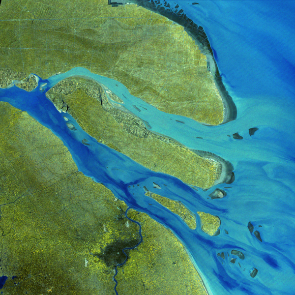
Landsat’s Early Look at the Yangtze Delta
This false-color image, captured by Landsat 1 on February 13, 1974, shows the landscape around Shanghai and the Yangtze River Delta. Using bands 7 (near-infrared), 6 (red), and 5 (green), the image highlights water in dark blue, sediment-laden channels in lighter shades of blue, and vegetation in shades of yellow and green.
This false-color image, captured by Landsat 1 on February 13, 1974, shows the landscape around Shanghai and the Yangtze River Delta. Using bands 7 (near-infrared), 6 (red), and 5 (green), the image highlights water in dark blue, sediment-laden channels in lighter shades of blue, and vegetation in shades of yellow and green.

Landsat 2 First Light Image of Alberta Canada
Landsat 2’s first light image features a slice of Alberta, Canada, captured on January 24, 1975 on Path 047 Row 023. This false color images uses two near infrared bands and the red band (Bands 7,6,5).
Learn more about Landsat 2 by visiting the Landsat 2 Mission Web Page
Landsat 2’s first light image features a slice of Alberta, Canada, captured on January 24, 1975 on Path 047 Row 023. This false color images uses two near infrared bands and the red band (Bands 7,6,5).
Learn more about Landsat 2 by visiting the Landsat 2 Mission Web Page
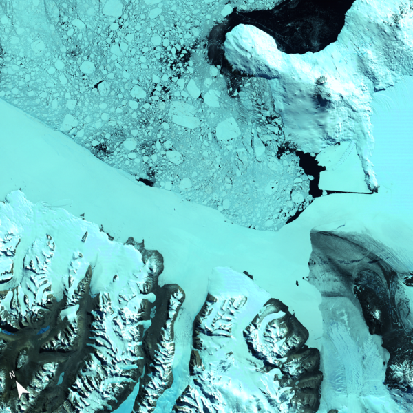
Early Satellite View of Ross Island and McMurdo Sound
Early Satellite View of Ross Island and McMurdo SoundThis Landsat 1 image, acquired on January 13, 1973, offers one of the earliest satellite perspectives of Antarctica’s Ross Island and McMurdo Sound. Captured using the Multispectral Scanner’s (MSS) near-infrared, red, and green bands (6, 5, 4), the image highlights the region's glaciated terrain, floating sea ice, and volcanic peaks.
Early Satellite View of Ross Island and McMurdo Sound
Early Satellite View of Ross Island and McMurdo SoundThis Landsat 1 image, acquired on January 13, 1973, offers one of the earliest satellite perspectives of Antarctica’s Ross Island and McMurdo Sound. Captured using the Multispectral Scanner’s (MSS) near-infrared, red, and green bands (6, 5, 4), the image highlights the region's glaciated terrain, floating sea ice, and volcanic peaks.
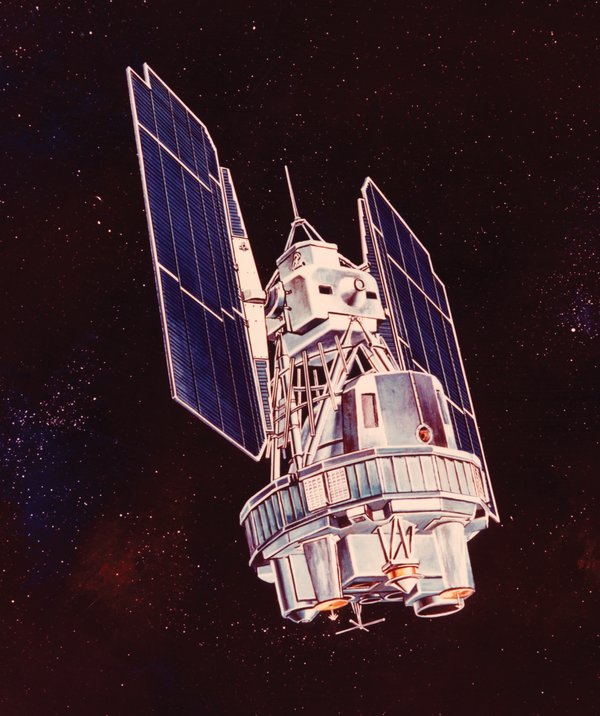
Illustration of Landsat 1
An artist's rendering of the pioneering Earth observation satellite that launched the Landsat program, providing critical data for monitoring land cover and environmental changes since 1972.
Learn more about the Landsat Mission
An artist's rendering of the pioneering Earth observation satellite that launched the Landsat program, providing critical data for monitoring land cover and environmental changes since 1972.
Learn more about the Landsat Mission
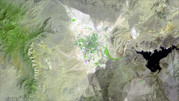
Las Vegas, 1972
This false-color Landsat 1 image, acquired on September 13, 1972, shows the Las Vegas metropolitan area in southern Nevada shortly after the launch of the first Landsat satellite. Lake Mead is visible east of the city, while the surrounding Mojave Desert and mountain ranges dominate the landscape.
This false-color Landsat 1 image, acquired on September 13, 1972, shows the Las Vegas metropolitan area in southern Nevada shortly after the launch of the first Landsat satellite. Lake Mead is visible east of the city, while the surrounding Mojave Desert and mountain ranges dominate the landscape.
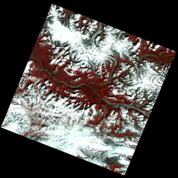
First Glimpse of Alaska’s Glaciers from Landsat
This early Landsat 1 image, acquired on July 31, 1972, captures the Kennicott, Nabesna, and Barnard Glaciers in southeastern Alaska—just a week after the satellite’s launch. Using bands 6, 5, and 4, the image reveals glacial ice, rugged mountain terrain, and braided rivers within the Wrangell–St. Elias region.
This early Landsat 1 image, acquired on July 31, 1972, captures the Kennicott, Nabesna, and Barnard Glaciers in southeastern Alaska—just a week after the satellite’s launch. Using bands 6, 5, and 4, the image reveals glacial ice, rugged mountain terrain, and braided rivers within the Wrangell–St. Elias region.

Landsat 1 views Alaska Fire
Within days of the launch, Landsat 1 acquired an image of an astounding 81,000-acre (327.8 square kilometers) fire burning in isolated, central Alaska. For the first time ever, scientists and resource management officials were able to see the full extent of damage from a fire in a single image while it was still burning.
Within days of the launch, Landsat 1 acquired an image of an astounding 81,000-acre (327.8 square kilometers) fire burning in isolated, central Alaska. For the first time ever, scientists and resource management officials were able to see the full extent of damage from a fire in a single image while it was still burning.

Landsat 1 First Light Image of Texas
Dallas-Fort Worth, Texas, slid into Landsat 1's view on July 25, 1972. In this false-color image, shades of red indicate vegetated land and grays and whites are urban or rocky surfaces. The composite image is shown using the near-infrared, red and green bands (bands 7, 5, 4) at a 60 meter resolution.
Dallas-Fort Worth, Texas, slid into Landsat 1's view on July 25, 1972. In this false-color image, shades of red indicate vegetated land and grays and whites are urban or rocky surfaces. The composite image is shown using the near-infrared, red and green bands (bands 7, 5, 4) at a 60 meter resolution.
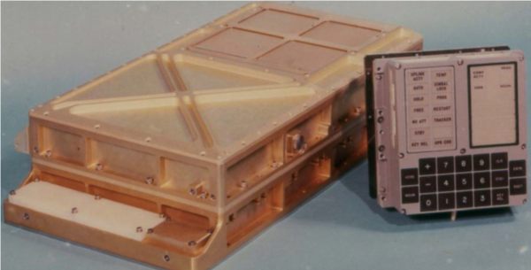
Apollo Guidance Computer (left) and DSKY (shorthand for "display and keyboard," right)
Apollo Guidance Computer (left) and DSKY (shorthand for "display and keyboard," right)Photo of the Apollo Guidance Computer (AGC, left) and DSKY ("display and keyboard," right) that provided computation and electronic interfaces for guidance, navigation, and control of the spacecraft.
Apollo Guidance Computer (left) and DSKY (shorthand for "display and keyboard," right)
Apollo Guidance Computer (left) and DSKY (shorthand for "display and keyboard," right)Photo of the Apollo Guidance Computer (AGC, left) and DSKY ("display and keyboard," right) that provided computation and electronic interfaces for guidance, navigation, and control of the spacecraft.