
Seals swim along the Oregon Coast. Modeling animal movement through landscapes is a key component to understanding population
ecology, how populations can be managed, how human actions impact the population.
Images
See our science through the images below.
Filter Total Items: 3542

Happy seals swim at the Oregon Coast
Seals swim along the Oregon Coast. Modeling animal movement through landscapes is a key component to understanding population
ecology, how populations can be managed, how human actions impact the population.

Tufted puffin flying over the Oregon Coast
Tufted puffin flying over the Oregon Coast. The Tufted Puffin – a seabird of the North Pacific Rim – has evinced steep declines off the west coast of the continental United States in recent years, but it is less clear that the species is declining in the northern portion of its range.
Tufted puffin flying over the Oregon Coast. The Tufted Puffin – a seabird of the North Pacific Rim – has evinced steep declines off the west coast of the continental United States in recent years, but it is less clear that the species is declining in the northern portion of its range.

Tufted puffins are an iconic species in the Pacific Northwest
Tufted puffins are an iconic species in the Pacific NorthwestTufted puffins are an iconic species in the Pacific Northwest that provide a wide range of ecological, economic, and historically important services such as ecotourism for local communities- and bringing marine derived nutrients to terrestrial habitats.

Ringtail in southwestern Oregon
This original photograph was taken during field work for her project looking at ringtail demographics and habitat use in southwestern Oregon.
This original photograph was taken during field work for her project looking at ringtail demographics and habitat use in southwestern Oregon.

Cover image for video "Climate Research and Development Program – Ariana Sutton-Grier"
Cover image for video "Climate Research and Development Program – Ariana Sutton-Grier"Cover image for video "Climate Research and Development Program – Ariana Sutton-Grier".
Cover image for video "Climate Research and Development Program – Ariana Sutton-Grier"
Cover image for video "Climate Research and Development Program – Ariana Sutton-Grier"Cover image for video "Climate Research and Development Program – Ariana Sutton-Grier".

Cover image for video "Climate Research and Development Program – Day in the Life of Climate R & D"
Cover image for video "Climate Research and Development Program – Day in the Life of Climate R & D"Cover image for video "Climate Research and Development Program – Day in the Life of Climate R & D".
Cover image for video "Climate Research and Development Program – Day in the Life of Climate R & D"
Cover image for video "Climate Research and Development Program – Day in the Life of Climate R & D"Cover image for video "Climate Research and Development Program – Day in the Life of Climate R & D".

3D QUIC-Fire Visualization
Example of a three-dimensional QUIC-Fire simulation. The example site is located in the Dixie Fire, CA. QUIC-Fire is a fast, 3-D simulation tool for prescribed fire planning. It can help managers understand the complex and dynamic behavior of wildland fires.
Example of a three-dimensional QUIC-Fire simulation. The example site is located in the Dixie Fire, CA. QUIC-Fire is a fast, 3-D simulation tool for prescribed fire planning. It can help managers understand the complex and dynamic behavior of wildland fires.

Lizzy's Blanding's Turtle
Lizzy Lang, graduate research assistant, Iowa State University, leads research on Blanding’s Turtle. Lizzy’s project helps decision-makers in Iowa and Illinois to make informed decisions about the endangered Blanding’s turtle.
Lizzy Lang, graduate research assistant, Iowa State University, leads research on Blanding’s Turtle. Lizzy’s project helps decision-makers in Iowa and Illinois to make informed decisions about the endangered Blanding’s turtle.

View of Gothic Mountain, Colorado
A view of Gothic Mountain from the Rocky Mountain Biological Laboratory research meadow in Gothic, Colorado.
A view of Gothic Mountain from the Rocky Mountain Biological Laboratory research meadow in Gothic, Colorado.

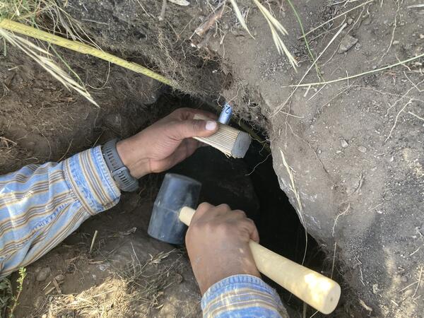
USGS researcher working with an eDNA autosampler
A USGS researcher working with a potable eDNA autosampler located next to a stream in Montana.
A USGS researcher working with a potable eDNA autosampler located next to a stream in Montana.

Motus tower in Olympic National Park
A Motus tower installed on the spillway of the former Glines Canyon Dam in Olympic National Park. The solar-powered array of radio antennae will detect the signals send by tiny transmitters known as “nanotags” that have been attached to small flying animals. This tower was installed to study bat movement behavior.
A Motus tower installed on the spillway of the former Glines Canyon Dam in Olympic National Park. The solar-powered array of radio antennae will detect the signals send by tiny transmitters known as “nanotags” that have been attached to small flying animals. This tower was installed to study bat movement behavior.

Researchers examine a bat wing
Researchers examine a bat wing while in the process of capturing bats to attach tiny Motus radio tags to track their movements.
Researchers examine a bat wing while in the process of capturing bats to attach tiny Motus radio tags to track their movements.

Researcher holds myotis bat during the process of tagging
Researcher holds myotis bat during the process of taggingA researcher holds a myotis bat during the process of capturing bats to fit them with Motus transmitters.
Researcher holds myotis bat during the process of tagging
Researcher holds myotis bat during the process of taggingA researcher holds a myotis bat during the process of capturing bats to fit them with Motus transmitters.

Grove of Aspen Trees in Colorado
A forest trail meanders through a grove of Aspen trees in Colorado during early autumn.
A forest trail meanders through a grove of Aspen trees in Colorado during early autumn.

Soil Monitoring Station in Elk Mountains, Colorado
Soil Monitoring Station in Elk Mountains, ColoradoA USGS scientist preparing a soil monitoring station for winter, with a view of Mt. Baldy in the Colorado Elk Mountains.
Soil Monitoring Station in Elk Mountains, Colorado
Soil Monitoring Station in Elk Mountains, ColoradoA USGS scientist preparing a soil monitoring station for winter, with a view of Mt. Baldy in the Colorado Elk Mountains.
Extracting a bulk density soil sample
A scientist carefully collects a soil sample to determine soil density. Accurate soil density measurements are required for scaling soil carbon from the plot to the landscape.
A scientist carefully collects a soil sample to determine soil density. Accurate soil density measurements are required for scaling soil carbon from the plot to the landscape.

Modeling to Support Proactive Approaches to Wildland Fire
Modeling to Support Proactive Approaches to Wildland FireScreen shot visualization of wind direction and velocity from a coupled/fire atmosphere model run of a wildfire (Dude Fire).
Modeling to Support Proactive Approaches to Wildland Fire
Modeling to Support Proactive Approaches to Wildland FireScreen shot visualization of wind direction and velocity from a coupled/fire atmosphere model run of a wildfire (Dude Fire).

Gothic Mountain, Colorado
A scenic view of Gothic Mountain in the Elk Mountains of Colorado. USGS scientists captured this photo while collecting soil sample data in the area.
A scenic view of Gothic Mountain in the Elk Mountains of Colorado. USGS scientists captured this photo while collecting soil sample data in the area.

Field crew prepares to measure and tag a bat
A team of biologists prepares to measure, weigh, and tag a captured bats. On the left, USGS biologist Gabe Reyes has a bat in a bag, used to separate and calm the bats. USGS biologist Julia Ersan is holding some alcohol used to ensure clean instruments and work surfaces, and USGS biologist Austin Waag is getting something out of a backpack.
A team of biologists prepares to measure, weigh, and tag a captured bats. On the left, USGS biologist Gabe Reyes has a bat in a bag, used to separate and calm the bats. USGS biologist Julia Ersan is holding some alcohol used to ensure clean instruments and work surfaces, and USGS biologist Austin Waag is getting something out of a backpack.
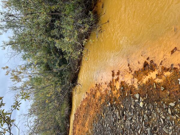
An orange tributary of the Kugururok River, Noatak National Preserve, Alaska
An orange tributary of the Kugururok River, Noatak National Preserve, AlaskaOrange streams are increasingly common in the Brooks Range of northern Alaska. The orange stream color reflects oxidized iron, but also often indicates elevated heavy metal concentrations. Our ongoing study aims to document these occurrences and the timing of their onset.

MuddyCreekChannel.jpg
Vegetation growth is assisting the Muddy Creek channel in becoming deeper and narrower (Carbon County, Wyoming). Photo by Patrick Anderson (USGS)
Vegetation growth is assisting the Muddy Creek channel in becoming deeper and narrower (Carbon County, Wyoming). Photo by Patrick Anderson (USGS)