



A Saildrone Explorer being towed in the harbor in Erie, PA at the beginning of a mission to collect data to improve fishery surveys in July 2023.
Images
See our science through the images below.
Filter Total Items: 3592

Saildrone being towed through Erie, PA harbor
A Saildrone Explorer being towed in the harbor in Erie, PA at the beginning of a mission to collect data to improve fishery surveys in July 2023.

Saildrone is towed onto Lake Erie, July 2023
A Saildrone Explorer being towed on Lake Erie at the beginning of a mission to collect data to improve fishery surveys in July 2023.
A Saildrone Explorer being towed on Lake Erie at the beginning of a mission to collect data to improve fishery surveys in July 2023.

Saildrone is towed into Lake Erie, July 2023
A Saildrone Explorer in the harbor being towed out onto Lake Erie for the beginning of a mission to collect data to improve fishery surveys on July 14, 2023.
A Saildrone Explorer in the harbor being towed out onto Lake Erie for the beginning of a mission to collect data to improve fishery surveys on July 14, 2023.

Saildrone is towed on Lake Erie, July 2023
A Saildrone Explorer being towed on Lake Erie at the beginning of a mission to collect data to improve fishery surveys in July 2023.
A Saildrone Explorer being towed on Lake Erie at the beginning of a mission to collect data to improve fishery surveys in July 2023.

Radio telemetry at Glacier Point, Yosemite
Austin Waag performing radio-telemetry at Glacier Point with Half Dome in the background, as part of a project tracking bats in Yosemite National Park.
Austin Waag performing radio-telemetry at Glacier Point with Half Dome in the background, as part of a project tracking bats in Yosemite National Park.

USGS scientist preparing specimens for the USGS Lepidoptera Research Collection
USGS scientist preparing specimens for the USGS Lepidoptera Research CollectionButterflies and moths are submitted to the KS WSC for the Lepidoptera Research Collection Citizen Science Project. Julie Dietze holds a sphinx moth received from Texas.
USGS scientist preparing specimens for the USGS Lepidoptera Research Collection
USGS scientist preparing specimens for the USGS Lepidoptera Research CollectionButterflies and moths are submitted to the KS WSC for the Lepidoptera Research Collection Citizen Science Project. Julie Dietze holds a sphinx moth received from Texas.

Vegetation and soil data collection at Castle Rocks, Idaho
Vegetation and soil data collection at Castle Rocks, IdahoA Project ROAM (Rapid and Other Methods for Assessment and Monitoring) crew collecting vegetation data at a complex plot with over 40 unique species.
Vegetation and soil data collection at Castle Rocks, Idaho
Vegetation and soil data collection at Castle Rocks, IdahoA Project ROAM (Rapid and Other Methods for Assessment and Monitoring) crew collecting vegetation data at a complex plot with over 40 unique species.
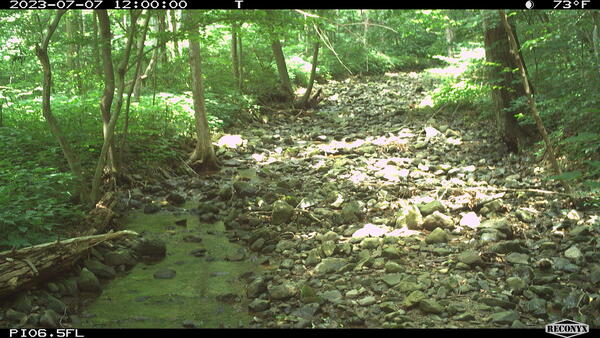
PI_06.5 Isolated pools
A still image taken from a USGS Flow Photo Explorer camera (Pl_06.5) shows isolated pools in a small stream in Shenandoah National Park.
A still image taken from a USGS Flow Photo Explorer camera (Pl_06.5) shows isolated pools in a small stream in Shenandoah National Park.

A triple-high mist net with El Capitan in the background
A triple-high mist net with El Capitan in the backgroundBiologists set up a triple-high mist net to capture bats with El Capitan, one of Yosemite's most iconic rock formations, in the background, as part of a study to track bats in Yosemite.
A triple-high mist net with El Capitan in the background
A triple-high mist net with El Capitan in the backgroundBiologists set up a triple-high mist net to capture bats with El Capitan, one of Yosemite's most iconic rock formations, in the background, as part of a study to track bats in Yosemite.

Western bumble bee on a sticky purple geranium flower
Western bumble bee on a sticky purple geranium flowerWestern bumble bee on a Geranium viscossium (sticky purple geranium) flower in Glacier National Park, Montana. Photo taken by USGS field crew in July 2023.
Western bumble bee on a sticky purple geranium flower
Western bumble bee on a sticky purple geranium flowerWestern bumble bee on a Geranium viscossium (sticky purple geranium) flower in Glacier National Park, Montana. Photo taken by USGS field crew in July 2023.

Western bumble bee on a common yarrow flower
Western bumble bee on a common yarrow flower in Glacier National Park, Montana. Photo taken by USGS field crew in July 2023.
Western bumble bee on a common yarrow flower in Glacier National Park, Montana. Photo taken by USGS field crew in July 2023.

RAMPS hosts park restoration ecologist from South Africa
RAMPS hosts park restoration ecologist from South AfricaRAMPS and NPS host South African National Park scientist, Dr. Mmoto Masubelele, for field visits to exchange information on restoration and climate adaptation strategies. From left to right: Seth Munson, Dr. Mmoto Masubelele, park biologist Mark Szydlo. Photo by Seth Munson (USGS).
RAMPS hosts park restoration ecologist from South Africa
RAMPS hosts park restoration ecologist from South AfricaRAMPS and NPS host South African National Park scientist, Dr. Mmoto Masubelele, for field visits to exchange information on restoration and climate adaptation strategies. From left to right: Seth Munson, Dr. Mmoto Masubelele, park biologist Mark Szydlo. Photo by Seth Munson (USGS).

A fiber-optic distributed temperature sensing monitoring array installed along Cement Creek near Silverton, Colorado.
A fiber-optic distributed temperature sensing monitoring array installed along Cement Creek near Silverton, Colorado.A long-term fiber-optic distributed temperature sensing monitoring array installed along Cement Creek near Silverton CO to track acid mine influenced groundwater discharge to the creek over time.
A fiber-optic distributed temperature sensing monitoring array installed along Cement Creek near Silverton, Colorado.
A fiber-optic distributed temperature sensing monitoring array installed along Cement Creek near Silverton, Colorado.A long-term fiber-optic distributed temperature sensing monitoring array installed along Cement Creek near Silverton CO to track acid mine influenced groundwater discharge to the creek over time.
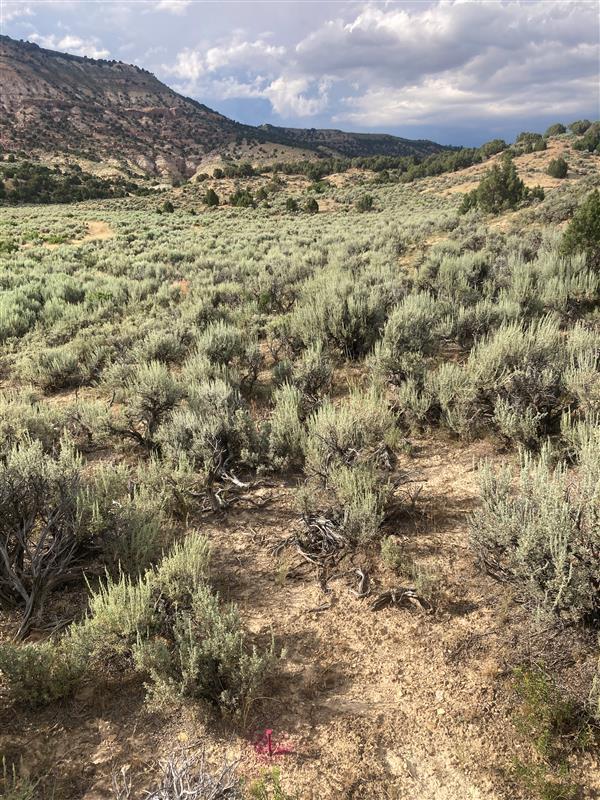
Undisturbed sagebrush landscape in Wyoming
This site south of Rock Springs in Wyoming represents an intact sagebrush ecosystem. It has not been burned or invaded by exotic annual grasses. Undisturbed sagebrush steppe has bare ground between shrubs which helps to limit the spread of wildfire. When cheatgrass invades fires can grow larger.
This site south of Rock Springs in Wyoming represents an intact sagebrush ecosystem. It has not been burned or invaded by exotic annual grasses. Undisturbed sagebrush steppe has bare ground between shrubs which helps to limit the spread of wildfire. When cheatgrass invades fires can grow larger.

Science to Understand Changing Ecosystems
The USGS provides science to understand, protect, restore, and solve problems in the world around us, and that includes interconnected communities of living things called ecosystems.
The USGS provides science to understand, protect, restore, and solve problems in the world around us, and that includes interconnected communities of living things called ecosystems.
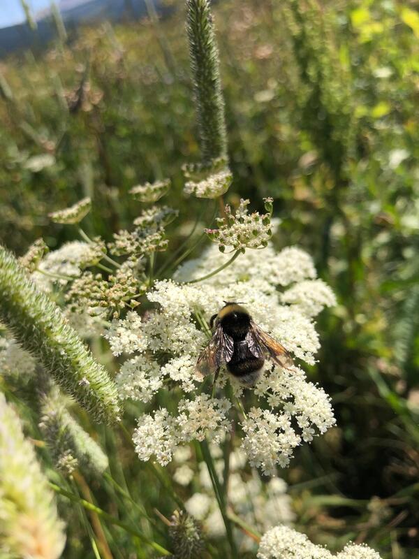
Western bumblebee on a yarrow flower
Western bumblebee on a yarrow flower in Glacier National Park, Montana.
Western bumblebee on a yarrow flower in Glacier National Park, Montana.
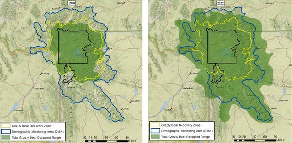
Occupied range of grizzly bears in the Greater Yellowstone Ecosystem: 1990 vs. 2022
Occupied range of grizzly bears in the Greater Yellowstone Ecosystem: 1990 vs. 2022The grizzly bear distribution represents the estimated geographic extent of occupied range of the Yellowstone grizzly bear population. The images show a comparison of their estimated geographic extent, with a 3-fold increase from 1990 (23,361 km2 or 9,020 mi2) to 2022 (70,101 km2 or 27,066 mi2).
Occupied range of grizzly bears in the Greater Yellowstone Ecosystem: 1990 vs. 2022
Occupied range of grizzly bears in the Greater Yellowstone Ecosystem: 1990 vs. 2022The grizzly bear distribution represents the estimated geographic extent of occupied range of the Yellowstone grizzly bear population. The images show a comparison of their estimated geographic extent, with a 3-fold increase from 1990 (23,361 km2 or 9,020 mi2) to 2022 (70,101 km2 or 27,066 mi2).

Pacific walrus group hauled-out on sea ice in the Chukchi Sea.
Pacific walrus group hauled-out on sea ice in the Chukchi Sea.Pacific walrus group hauled-out on sea ice in the Chukchi Sea. The photo was captured during a survey of the age structure of the population to evaluate population status. Observers assign each animal in a group to an age/sex category according to published criteria. USFWS Permit No. 33776D.
Pacific walrus group hauled-out on sea ice in the Chukchi Sea.
Pacific walrus group hauled-out on sea ice in the Chukchi Sea.Pacific walrus group hauled-out on sea ice in the Chukchi Sea. The photo was captured during a survey of the age structure of the population to evaluate population status. Observers assign each animal in a group to an age/sex category according to published criteria. USFWS Permit No. 33776D.
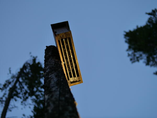
Bats roosting in a bat box
Bats roosting in a bat box during NABat Fieldwork in 2023.
Bats roosting in a bat box during NABat Fieldwork in 2023.

Lepidoptera Research Collection (LRC)
A Citizen Science Flyer requesting people to mail in deceased butterflies, moths, and skippers to help begin a USGS Scientific Collection to further research related to the decline of insect populations.
A Citizen Science Flyer requesting people to mail in deceased butterflies, moths, and skippers to help begin a USGS Scientific Collection to further research related to the decline of insect populations.
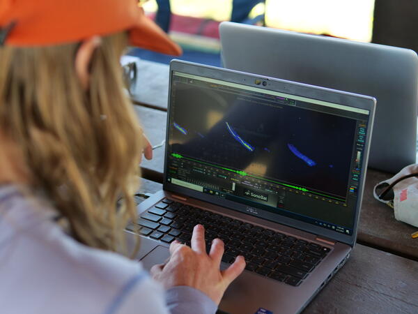
Examining an acoustic bat recording
Andrea Schuhmann examines an acoustic bat recording using a software for bat call analysis during NA Bat Fieldwork in 2023.
Andrea Schuhmann examines an acoustic bat recording using a software for bat call analysis during NA Bat Fieldwork in 2023.