
How We Use Water
How We Use Water
Water Use in the United States
Integrated Water Availability Assessments (IWAAs)
USGS announces 10 IWAAs pilot projects
Supporting the development of national and regional Integrated Water Availability Assessments
Supporting the development of national and regional Integrated Water Availability Assessments
Find water science information and activities related to the different ways we use water.
National Water Availability Assessment Data Companion
National Water Availability Assessment Data Companion

The Data Companion provides model-based estimates of water availability and use.
Data Visualization of Water Use in the U.S. 2015
Data Visualization of Water Use in the U.S. 2015
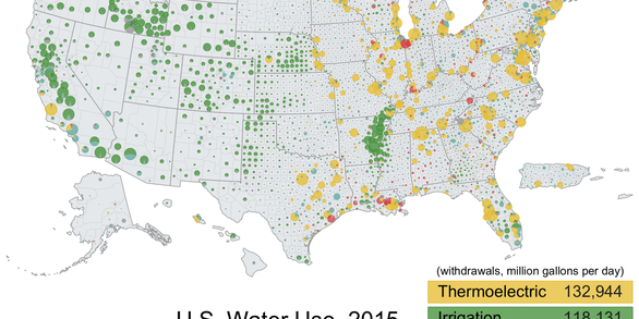
Explore water use data by state and county for 2015
Filter Total Items: 102

Regional Water Availability Assessment: Upper Colorado River Basin
Regional Water Availability Assessments are scientific assessments of water availability in different hydrologic regions across the Nation. In the Upper Colorado River Basin, the USGS will conduct a focused assessment of how snowpack and snowmelt influence hydrology and water quality, and an integrated and comprehensive assessment of multiple water quantity, quality and use factors.

Regional Water Availability Assessment: Delaware River Basin
Regional Water Availability Assessments are scientific assessments of water availability in different hydrologic regions across the Nation. In the Delaware River Basin, the USGS will conduct a focused assessment of increasing freshwater salinity and an integrated and comprehensive assessment of multiple water quantity, quality and use factors.

Proxies Project
The Proxies Project is a series of studies to improve our understanding of water contaminants and water quality hazards. These studies develop models and technical approaches for estimating concentrations and assessing risk associated with: - harmful algal blooms (HABs) - per- and polyfluoroalkyl substances (PFAS) - 12 elements of concern (EoC)

Understanding Water Availability
The United States faces growing challenges to its water supply, and we need to know where there is not enough water, where we have more than we need, and the quality of the water. The USGS is charged with understanding and reporting on water availability including influences on water supply (how much water and of what quality) and water demand (how much water do humans and ecosystems need).

Water Quality After Wildfire
Wildfires pose a substantial risk to water supplies because they can lead to severe flooding, erosion, and delivery of sediment, nutrients, and metals to rivers, lakes, and reservoirs. The USGS works with federal and state land managers and local water providers to monitor and assess water quality after wildfires in order to help protect our Nation’s water resources.

CASCaDE: Computational Assessments of Scenarios of Change for the Delta Ecosystem
The Delta of the Sacramento and San Joaquin rivers provides drinking water supplies to two-thirds of Californians, and is a fragile ecosystem home to threatened and endangered species. The CASCaDE project builds on several decades of USGS science to address the goals of achieving water supply reliability and restoring the ecosystems in the Bay-Delta system.

Water-Use Data and Research (WUDR) program
The USGS Water-Use Data and Research (WUDR) program provides financial assistance through cooperative agreements with State water resource agencies to improve the availability, quality, compatibility, and delivery of water-use data that is collected or estimated by States.

Karst Aquifers
Karst terrain is created from the dissolution of soluble rocks, principally limestone and dolomite. Karst areas are characterized by distinctive landforms (like springs, caves, sinkholes) and a unique hydrogeology that results in aquifers that are highly productive but extremely vulnerable to contamination.

Integrated Water Science (IWS) Basins
The U.S. Geological Survey is integrating its water science programs to better address the Nation’s greatest water resource challenges. At the heart of this effort are plans to intensively study several Integrated Water Science (IWS) basins—medium-sized watersheds (10,000-20,000 square miles) and underlying aquifers—over the next decade. The IWS basins will represent a wide range of environmental...

Next Generation Water Observing System: Illinois River Basin
The Next Generation Water Observing System provides high-fidelity, real-time data on water quantity, quality, and use to support modern water prediction and decision-support systems that are necessary for informing water operations on a daily basis and decision-making during water emergencies. The Illinois River Basin provides an opportunity to implement the NGWOS in a system challenged by an...

Next Generation Water Observing System: Upper Colorado River Basin
The Next Generation Water Observing System (NGWOS) provides high-fidelity, real-time data on water quantity, quality, and use to support modern prediction and decision-support systems that are necessary for informing water operations on a daily basis and decision-making during water emergencies. The headwaters of the Colorado and Gunnison River Basins provide an opportunity to implement NGWOS in a...

Principal Aquifers of the United States
This website compiles USGS resources and data related to principal aquifers including Aquifer Basics, principal aquifers maps and GIS data, and the National Aquifer Code Reference List.