
How We Use Water
How We Use Water
Water Use in the United States
Integrated Water Availability Assessments (IWAAs)
USGS announces 10 IWAAs pilot projects
Supporting the development of national and regional Integrated Water Availability Assessments
Supporting the development of national and regional Integrated Water Availability Assessments
Find water science information and activities related to the different ways we use water.
National Water Availability Assessment Data Companion
National Water Availability Assessment Data Companion

The Data Companion provides model-based estimates of water availability and use.
Data Visualization of Water Use in the U.S. 2015
Data Visualization of Water Use in the U.S. 2015
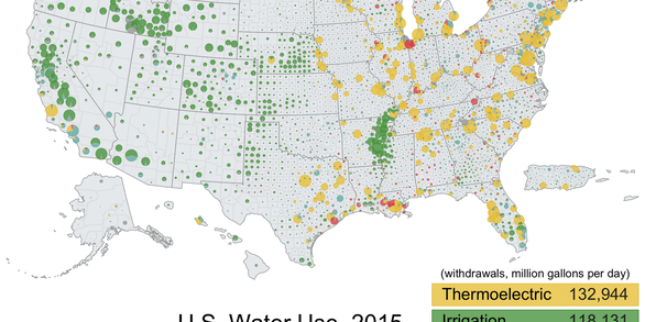
Explore water use data by state and county for 2015
Filter Total Items: 102

Powder River: Data for Cross-Channel Profiles at 22 Sites in Southeastern Montana, 1975 through 2019
Powder River rises in the Bighorn Mountains of Wyoming and flows northward through a semi-arid landscape in Wyoming and Montana to the Yellowstone River. The river drains an area of 34,700 square kilometers and has an average discharge of about 500 million cubic meters per year. Cross-channel profile data were collected at 22 sites on the river and its tributaries from 1975 through 2014.

Transboundary Assessments of Water Quality in the Pacific Northwest
In 2019, the USGS began studying the baseline water-quality of selected transboundary rivers in the Pacific Northwest. These studies are designed to characterize current water-quality conditions so as to facilitate future assessments of potential impacts related to upstream mining activities.

Atmospheric Warming, Loss of Snow Cover, and Declining Colorado River Flow
Declining snow cover is playing a key role in decreasing the flow of the Colorado River, “the lifeblood of the Southwest,” by enabling increased evaporation. As the warming continues, increasingly severe water shortages are expected.

SPARROW Mappers
SPARROW mappers are interactive tools that allow the user to explore river streamflow and nutrient and sediment loads and yields and the importance of different sources of contaminants in a particular river basin. Data can be visualized using maps and interactive graphs and tables, and rankings can be shown by state, major watershed, hydrologic unit (HUC), and catchment.

Urban Waters Federal Partnership: Cooperative Matching Funds Projects
The Urban Waters Federal Partnership reconnects urban communities with their waterways by improving coordination among federal agencies, particularly those impacted by pollution or economic distress.

Harmful Algal Bloom (HAB): Cooperative Matching Funds Projects
New projects from coast to coast will advance the research on harmful algal blooms (HABs) in lakes, reservoirs and rivers. The vivid emerald-colored algal blooms are caused by cyanobacteria, which can produce cyanotoxins that threaten human health and aquatic ecosystems and can cause major economic damage.

StreamStats
StreamStats provides access to spatial analytical tools that are useful for water-resources planning and management, and for engineering and design purposes. The map-based user interface can be used to delineate drainage areas, get basin characteristics and estimates of flow statistics, and more. Available information varies from state to state.

National Water-Quality Assessment (NAWQA)
Our surface water, groundwater, and aquatic ecosystems are priceless resources, used by people across the Nation for drinking, irrigation, industry, and recreation. The National Water-Quality Assessment (NAWQA) Project is a leading source of scientific data and knowledge for development of science-based policies and management strategies to improve and protect our water resources.

Nutrients and Eutrophication
Like people, plants need nutrients, but too much of a good thing can be a problem. Nutrients, such as nitrogen and phosphorus, occur naturally, but most of the nutrients in our waterways come from human activities and sources—fertilizers, wastewater, automobile exhaust, animal waste. The USGS investigates the source, transport, and fate of nutrients and their impacts on the world around us.

Drinking Water and Source Water Research
Reliable drinking water is vital for the health and safety of all Americans. The USGS monitors and assesses the quality of the water used as a source for our nation's drinking water needs.

Hydrologic and Erosion Responses of Burned Watersheds
The enhanced probability of catastrophic wildfires has increased our need to understand the risk of floods, erosion, and debris and contaminant transport in burned watersheds. This project investigates the relation between rainfall intensity and peak discharge; erosion and deposition processes; and water-quality impacts to minimize the loss of life and property resulting from post-wildfire floods.

Office of the Delaware River Master
In 1954, the U.S. Supreme Court issued a Decree in State of New Jersey v. State of New York and City of New York in which the Court established the position of the Delaware River Master.