
How We Use Water
How We Use Water
Water Use in the United States
Integrated Water Availability Assessments (IWAAs)
USGS announces 10 IWAAs pilot projects
Supporting the development of national and regional Integrated Water Availability Assessments
Supporting the development of national and regional Integrated Water Availability Assessments
Find water science information and activities related to the different ways we use water.
National Water Availability Assessment Data Companion
National Water Availability Assessment Data Companion

The Data Companion provides model-based estimates of water availability and use.
Data Visualization of Water Use in the U.S. 2015
Data Visualization of Water Use in the U.S. 2015
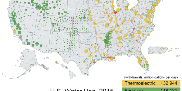
Explore water use data by state and county for 2015
Filter Total Items: 102

Apalachicola-Chattahoochee-Flint River Basin Focus Area Study
As one of several National Focus Area Studies within the USGS National Water Census (NWC) the USGS completed a 3-year study of water availability and use in the Apalachicola-Chattahoochee-Flint (ACF) River Basin.

Upper Rio Grande Basin Focus Area Study
USGS is undertaking a 3-year study of water use, availability, and change in the Upper Rio Grande Basin. This study area runs 670 miles from its headwaters in Colorado through New Mexico and northern Mexico to Texas, and will compile existing information and add new scientific data and interpretation to help stakeholders face current and future water issues.

Delaware River Basin Focus Area Study
As one of several National Focus Area Studies within the USGS National Water Census (NWC), the USGS completed a 3-year study of water availability and use in the Delaware River Basin.

Groundwater Quality—Current Conditions and Changes Through Time
Is groundwater the source of your drinking water? The USGS is assessing the quality of groundwater used for public supply using newly collected data along with existing water-quality data. Learn more about this invisible, vital resource so many of us depend on.

Predicting Groundwater Quality in Unmonitored Areas
Groundwater provides nearly one-half of the Nation’s drinking water, and sustains the steady flow of streams and rivers and the ecological systems that depend on that flow. Unless we drill a well, how can we know the quality of the groundwater below? Learn about how the USGS is using sophisticated techniques to predict groundwater quality and view national maps of groundwater quality.

Factors Affecting Vulnerability of Public-Supply Wells to Contamination
More than 100 million people in the United States—about 35 percent of the population—receive their drinking water from public-supply wells. These systems can be vulnerable to contamination from naturally occurring constituents, such as radon, uranium and arsenic, and from commonly used manmade chemicals, such as fertilizers, pesticides, solvents, and gasoline hydrocarbons. Learn about the...

Surface-Water Quality and Ecology
Research by the USGS National Water Quality Assessment (NAWQA) Project on water quality of rivers and streams covers a broad range of topics, from nonpoint pollution issues to vulnerability of aquatic ecosystems. Dive in and find out more about current water-quality conditions, how and where water quality is changing, and the latest information on pesticides, nutrients, and other contaminants.

Estimated Annual Agricultural Pesticide Use
These tables, maps, and graphs provide estimates of U.S. agricultural pesticide use suitable for evaluating national and regional patterns and trends of annual pesticide use.

Volatile Organic Compounds (VOCs)
Volatile organic compounds (VOCs) are chemicals that both vaporize into air and dissolve in water. VOCs are pervasive in daily life, because they’re used in industry, agriculture, transportation, and day-to-day activities around the home. Once released into groundwater, many VOCs are persistent and can migrate to drinking-water supply wells.

Linking Selenium Sources to Ecosystems: Mining
Environmental sources of selenium (Se) such as from organic-enriched sedimentary deposits are geologic in nature and thus can occur on regional scales. A constructed map of the global distribution of Se source rocks informs potential areas of reconnaissance for modeling of Se risk including the phosphate deposits of southeastern Idaho and the coals of Appalachia.

Linking Selenium Sources to Ecosystems: Irrigation
Adverse effects of selenium (Se) on fish and waterfowl in wetlands receiving agricultural drainage occurred in the 1980s in the San Joaquin Valley of California. The identified mechanisms of Se enrichment helped resolve Se toxicity problems associated with irrigated agriculture in the arid West. Bioaccumulation of Se in ancient marine sediments is postulated as a primary pathway in source rocks.

Linking Selenium Sources to Ecosystems: Refining
The San Francisco Bay-Delta receives selenium (Se) internally from oil refineries and externally through riverine agricultural discharges. Predator species considered at risk from Se consume the estuary’s dominant bivalve, C. amurensis, an efficient bioaccumulator of Se. Modeling predicts site-specific ecological risk and derives a range of protective Se concentrations for use by decision-makers.