
How We Use Water
How We Use Water
Water Use in the United States
Integrated Water Availability Assessments (IWAAs)
USGS announces 10 IWAAs pilot projects
Supporting the development of national and regional Integrated Water Availability Assessments
Supporting the development of national and regional Integrated Water Availability Assessments
Find water science information and activities related to the different ways we use water.
National Water Availability Assessment Data Companion
National Water Availability Assessment Data Companion

The Data Companion provides model-based estimates of water availability and use.
Data Visualization of Water Use in the U.S. 2015
Data Visualization of Water Use in the U.S. 2015
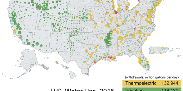
Explore water use data by state and county for 2015
Filter Total Items: 104

Large Oil Spills
Oil spills, such as the 2010 Deepwater Horizon Oil Spill, are impactful environmental disasters that have long lasting effects to the landscape, native species, and inhabitants who depend on the area. The USGS explores the adverse effect that large-scale oil spills have on the environment and helps responders prepare for environmental recovery and rehabilitation.

Public Supply Water Use
Public supply refers to water withdrawn by public and private water suppliers that provide water to at least 25 people or have a minimum of 15 connections. Public-supply water is delivered to users for domestic, commercial, and industrial purposes. Part of the total is used for public services, such as public pools, parks, firefighting, water and wastewater treatment, and municipal buildings, and...

Domestic Water Use
Domestic water use includes indoor and outdoor uses at residences, and includes uses such as drinking, food preparation, bathing, washing clothes and dishes, flushing toilets, watering lawns and gardens, and maintaining pools. Domestic water use includes potable and non-potable water provided to households by a public water supplier (domestic deliveries) and self-supplied water use. Self-supplied...

Irrigation Water Use
Irrigation water use includes water that is applied by an irrigation system to sustain plant growth in agricultural and horticultural practices. Irrigation also includes water that is used for pre-irrigation, frost protection, chemical application, weed control, field preparation, crop cooling, harvesting, dust suppression, and leaching salts from the root zone. Estimates of irrigation withdrawals...

Thermoelectric Power Water Use
Water for thermoelectric power is used in the process of generating electricity with steam-driven turbine generators. Since 2000, thermoelectric-power withdrawals have been compiled by cooling-system type. Once-through cooling refers to cooling systems in which water is circulated through heat exchangers, and then returned to the source. Recirculating cooling refers to cooling systems in which...

Industrial Water Use
Industrial withdrawals provide water for such purposes as fabricating, processing, washing, diluting, cooling, or transporting a product; incorporating water into a product; or for sanitation needs within the manufacturing facility. Some industries that use large amounts of water produce such commodities as food, paper, chemicals, refined petroleum, or primary metals. Water for industrial use may...

Mining Water Use
Mining water use is water used for the extraction of minerals that may be in the form of solids, such as coal, iron, sand, and gravel; liquids, such as crude petroleum; and gases, such as natural gas. The category includes quarrying, milling of mined materials, injection of water for secondary oil recovery or for unconventional oil and gas recovery (such as hydraulic fracturing), and other...

Livestock Water Use
Livestock water use is water associated with livestock watering, feedlots, dairy operations, and other on-farm needs. Livestock includes dairy cows and heifers, beef cattle and calves, sheep and lambs, goats, hogs and pigs, horses, and poultry. Other livestock water uses include cooling of facilities for the animals and products, dairy sanitation and wash down of facilities, animal waste-disposal...

Aquaculture Water Use
Aquaculture water use is water associated with raising organisms that live in water—such as finfish and shellfish—for food, restoration, conservation, or sport. Aquaculture production occurs under controlled feeding, sanitation, and harvesting procedures primarily in ponds, flowthrough raceways, and, to a lesser extent, cages, net pens, and closed-recirculation tanks.

Pesticides and Water Quality
Pesticides are chemicals designed to kill pests, including insects (insecticides), weeds (herbicides), and fungi (fungicides). The USGS assesses the occurrence and behavior of pesticides in streams, lakes, and groundwater and the potential for pesticides to contaminate our drinking-water supplies or harm aquatic ecosystems.

Mercury
Mercury is a potent neurotoxin that can affect the human nervous system. Eating fish contaminated with mercury can cause serious harm to people and wildlife.

Metals and Other Trace Elements
Metals, metalloids, and radionuclides all are trace elements that occur naturally in the Earth's crust. In small quantities many trace elements are essential for health in all living organisms, but some trace elements can be toxic or cause cancer, and some can bioaccumulate. The USGS investigates where and how trace elements make their way into our Nation's surface water and groundwater.