
Milk River at Havre at NWS flood stage
All Multimedia
Access all multimedia to include images, video, audio, webcams, before-after imagery, and more. Filter and explore with filtering options to refine search.
Filter Total Items: 24926

Milk River at Havre at NWS flood stage

Oh Buoy!
crew of the R/V Savannah recover the buoy deployed at the offshore site to record meteorological data.
crew of the R/V Savannah recover the buoy deployed at the offshore site to record meteorological data.

Overflows from the perched lava pond within west pit
Overflows from the perched lava pond within west pitOverflows from the perched lava pond within west pit, a small crater adjacent to the main Pu‘u ‘Ō‘ō crater on Kīlauea Volcano's East Rift Zone, continue to build up the levees around the pond. The rising level of the perched lava pond during the past month is a sign of the increasing pressure within the magma system beneath Pu‘u ‘Ō‘ō.

Reston Stable Isotope Laboratory Solid Reference Materials
Reston Stable Isotope Laboratory Solid Reference MaterialsReston Stable Isotope Laboratory Solid Reference Materials
Reston Stable Isotope Laboratory Solid Reference Materials
Reston Stable Isotope Laboratory Solid Reference MaterialsReston Stable Isotope Laboratory Solid Reference Materials

After the Flames talk by Steven Sobieszczyk
USGS hydrologist, Steven Sobieszcyk, on stage at Alberta Rose Theater talking about the science behind the Eagle Creek Fire response.
USGS hydrologist, Steven Sobieszcyk, on stage at Alberta Rose Theater talking about the science behind the Eagle Creek Fire response.

HayWired Scenario - Movie
The HayWired earthquake scenario, led by the U.S. Geological Survey (USGS), anticipates the impacts of a hypothetical magnitude-7.0 earthquake on the Hayward Fault.
The HayWired earthquake scenario, led by the U.S. Geological Survey (USGS), anticipates the impacts of a hypothetical magnitude-7.0 earthquake on the Hayward Fault.

Kanakee River at Davis, IN - gage equipment
Kanakee River at Davis, IN - gage equipment

Kankakee River at Davis, IN - downstream view
Kankakee River at Davis, IN - downstream view

Kankakee River at Davis, IN - gage equipment
Kankakee River at Davis, IN - gage equipment

Landsat in Action - Studying Phenology with Patrick Hostert
Landsat in Action - Studying Phenology with Patrick HostertPatrick Hostert from the University of Berlin discusses the value of Landsat's long archive to studying phenology.
Landsat in Action - Studying Phenology with Patrick Hostert
Landsat in Action - Studying Phenology with Patrick HostertPatrick Hostert from the University of Berlin discusses the value of Landsat's long archive to studying phenology.

Landsat in Action - The Accuracy of Landsat with Jeff Masek
Landsat in Action - The Accuracy of Landsat with Jeff MasekLandsat 9 Project Scientist Jeff Masek discusses the ways Landsat data is used and how important it is to have high quality data.
Landsat in Action - The Accuracy of Landsat with Jeff Masek
Landsat in Action - The Accuracy of Landsat with Jeff MasekLandsat 9 Project Scientist Jeff Masek discusses the ways Landsat data is used and how important it is to have high quality data.
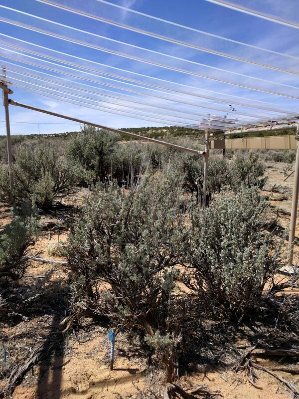
Rainout shelters allow researchers to study the effects of drought
Rainout shelters allow researchers to study the effects of droughtThis rainout shelter blcoks about 35% of the natural rainfall, allowing researchers to understand the effects of drought on plants in the southwestern United States.
Rainout shelters allow researchers to study the effects of drought
Rainout shelters allow researchers to study the effects of droughtThis rainout shelter blcoks about 35% of the natural rainfall, allowing researchers to understand the effects of drought on plants in the southwestern United States.

Time-Lapse on Rim of Pu`u `Ō`ō
This time-lapse image sequence taken by a time-lapse camera on the rim of Pu‘u ‘Ō‘ō's west pit, spans March 20 to April 18. The sequence, of approximately one image per day, shows the growth of the lava pond within the west pit as it developed into a perched lava pond. This sequence is looped 4 times.
This time-lapse image sequence taken by a time-lapse camera on the rim of Pu‘u ‘Ō‘ō's west pit, spans March 20 to April 18. The sequence, of approximately one image per day, shows the growth of the lava pond within the west pit as it developed into a perched lava pond. This sequence is looped 4 times.

Cattaraugus Creek near Springville, NY
ADCP measurement on a snowy day at the Cattaraugus Creek near Springville, NY
ADCP measurement on a snowy day at the Cattaraugus Creek near Springville, NY

Eagle Ford Test Well Drilling in Texas
USGS researchers drill a research well located on the south side of U.S. 90, 7.1 miles east of Brackettville, Texas. This core was drilled by USGS during field work for an oil and gas assessment for the Eagle Ford of the Gulf Coast Basins. Cores like these provide information on the various rock layers, such as their make-up, their age, etc.
USGS researchers drill a research well located on the south side of U.S. 90, 7.1 miles east of Brackettville, Texas. This core was drilled by USGS during field work for an oil and gas assessment for the Eagle Ford of the Gulf Coast Basins. Cores like these provide information on the various rock layers, such as their make-up, their age, etc.
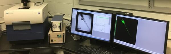
High-Content Screening Laboratory -- Columbia, Missouri
High-Content Screening Laboratory -- Columbia, MissouriHigh-Content Screening Laboratory -- Columbia, Missouri
High-Content Screening Laboratory -- Columbia, Missouri
High-Content Screening Laboratory -- Columbia, MissouriHigh-Content Screening Laboratory -- Columbia, Missouri
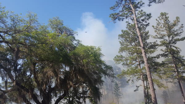
Prescribed Burning in Florida
A prescribed burn being monitored by an aerial drone. Dr. Terando is working with researchers at Tall Timbers to understand how climate change could affect fire management in the Southeast.
A prescribed burn being monitored by an aerial drone. Dr. Terando is working with researchers at Tall Timbers to understand how climate change could affect fire management in the Southeast.
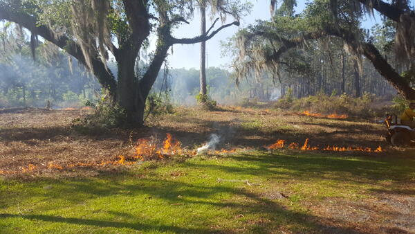
Prescribed burning management in a Florida Forest
A prescribed burn at Tall Timbers Research Station, Florida. Dr. Terando is working with researchers at Tall Timbers to understand how climate change could affect fire management in the Southeast.
A prescribed burn at Tall Timbers Research Station, Florida. Dr. Terando is working with researchers at Tall Timbers to understand how climate change could affect fire management in the Southeast.

Rainout shelters allow researchers to study effects of drought
Rainout shelters allow researchers to study effects of droughtRainout shelters block about 35% of natural rainfall, allowing researchers to study the effects of drought on plants in the arid and semiarid southwestern United States.
Rainout shelters allow researchers to study effects of drought
Rainout shelters allow researchers to study effects of droughtRainout shelters block about 35% of natural rainfall, allowing researchers to study the effects of drought on plants in the arid and semiarid southwestern United States.
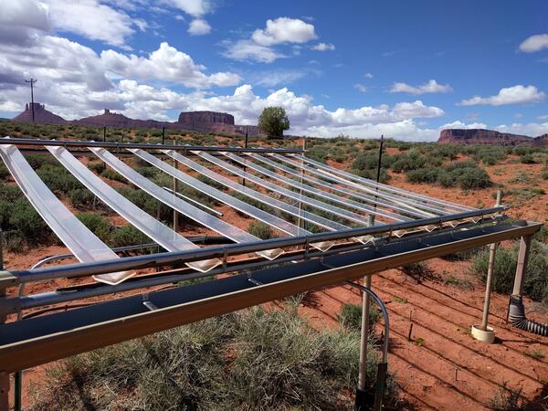
Rainout structures allow researchers to study the effects of drought
Rainout structures allow researchers to study the effects of droughtThis rainout structure blocks about 35% of the natural rainfall, allowing researchers to study the effects of drought on plants in the southwestern United States.
Rainout structures allow researchers to study the effects of drought
Rainout structures allow researchers to study the effects of droughtThis rainout structure blocks about 35% of the natural rainfall, allowing researchers to study the effects of drought on plants in the southwestern United States.
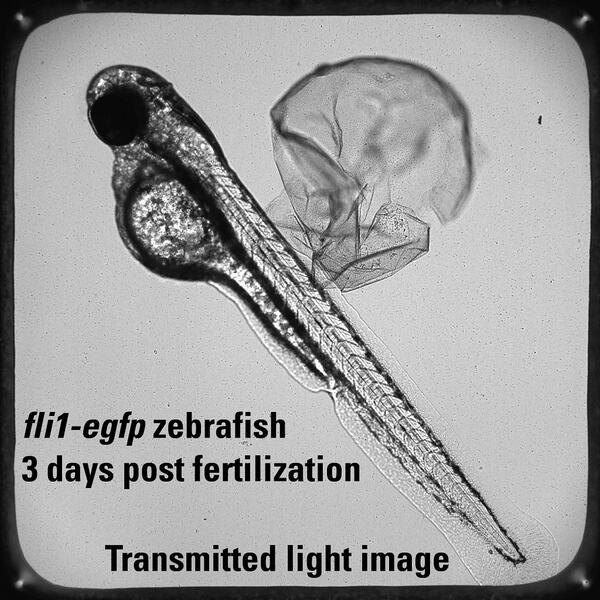
This is an example of a 72 hour post fertilization
This is an example of a 72 hour post fertilizationThis is an example of a 72 hour post fertilization fli1:egfp zebrafish (3 millimeters long) imaged under transmitted light. The same imaging system with was used.
This is an example of a 72 hour post fertilization
This is an example of a 72 hour post fertilizationThis is an example of a 72 hour post fertilization fli1:egfp zebrafish (3 millimeters long) imaged under transmitted light. The same imaging system with was used.