Spring wildflowers captured on California's Channel Islands.
The USGS Western Ecological Research Center's Dr. Kathryn McEachern studies plant ecology and restoration on the Channel Islands. Learn more here.

Official websites use .gov
A .gov website belongs to an official government organization in the United States.
Secure .gov websites use HTTPS
A lock () or https:// means you’ve safely connected to the .gov website. Share sensitive information only on official, secure websites.
Explore our planet through photography and imagery, including climate change and water all the way back to the 1800s when the USGS was surveying the country by horse and buggy.

Spring wildflowers captured on California's Channel Islands.
The USGS Western Ecological Research Center's Dr. Kathryn McEachern studies plant ecology and restoration on the Channel Islands. Learn more here.
Spring wildflowers captured on California's Channel Islands.
The USGS Western Ecological Research Center's Dr. Kathryn McEachern studies plant ecology and restoration on the Channel Islands. Learn more here.

USGS scientist Hal Nelson wades in a stock tank to install a fitting on the discharge pipe of a groundwater well to facilitate water quality sampling in the western Plains of San Agustin. Photo taken by Jeff Pepin on April 4th, 2019.
USGS scientist Hal Nelson wades in a stock tank to install a fitting on the discharge pipe of a groundwater well to facilitate water quality sampling in the western Plains of San Agustin. Photo taken by Jeff Pepin on April 4th, 2019.

The weather was warm and sunny during a routine visit to the Halema‘uma‘u webcam. No significant changes were observed, and no rockfalls were heard.
The weather was warm and sunny during a routine visit to the Halema‘uma‘u webcam. No significant changes were observed, and no rockfalls were heard.

David Sullivan, USGS, using an ice bar to chip away at the ice built up on the trail to get down to the water-quality sampling site at USGS gage Connecticut River near Thompsonville, CT
David Sullivan, USGS, using an ice bar to chip away at the ice built up on the trail to get down to the water-quality sampling site at USGS gage Connecticut River near Thompsonville, CT

Theresa Armijo, USGS, collecting water-quality samples from the Connecticut River by USGS gage 01184000, Connecticut River near Thompsonville
Theresa Armijo, USGS, collecting water-quality samples from the Connecticut River by USGS gage 01184000, Connecticut River near Thompsonville

Colin Sweeney, USGS, collecting water-quality samples from the Connecticut River, CT
Colin Sweeney, USGS, collecting water-quality samples from the Connecticut River, CT

As the sun rose above Mauna Kea (background) on July 6, 1975, eruptive fissures along the Northeast Rift Zone of Mauna Loa fed voluminous ‘a‘ā lava flows that quickly moved down the north flank of the volcano. USGS photo by D. Peterson.
As the sun rose above Mauna Kea (background) on July 6, 1975, eruptive fissures along the Northeast Rift Zone of Mauna Loa fed voluminous ‘a‘ā lava flows that quickly moved down the north flank of the volcano. USGS photo by D. Peterson.

A hyperpigmented melanistic skin lesion on a Smallmouth Bass from the Chesapeake Bay Watershed.
A hyperpigmented melanistic skin lesion on a Smallmouth Bass from the Chesapeake Bay Watershed.

SPMSC scientist Lauren Toth conducts a photographic survey of Porter Patch reef off Key Largo, one of the sites that has been surveyed as part of FWRI’s Coral Reef Ecosystem Monitoring project since 1996.
SPMSC scientist Lauren Toth conducts a photographic survey of Porter Patch reef off Key Largo, one of the sites that has been surveyed as part of FWRI’s Coral Reef Ecosystem Monitoring project since 1996.

Brittney Izbicki, USGS, at the edge of the ice in the Connecticut River, preparing to collect water-quality samples.
Brittney Izbicki, USGS, at the edge of the ice in the Connecticut River, preparing to collect water-quality samples.

In Photo: Berm of Jim Foot Key about 1.5 years after Hurricane Irma. The red circle indicates the same position as shown in the April 2014 photo. The mature mangrove trees have not recovered from the storm.
In Photo: Berm of Jim Foot Key about 1.5 years after Hurricane Irma. The red circle indicates the same position as shown in the April 2014 photo. The mature mangrove trees have not recovered from the storm.

June 2018 flooding along Elk Creek in Augusta, Montana
June 2018 flooding along Elk Creek in Augusta, Montana

A 3-4m (10-12 ft) high outcrop of basalt lava, part of a broader lava flow. These flows were erupted about 300,000 years ago following basalt dike intrusions in a rear-arc region of northern California. The eruptions of three of these flows are thought to have taken place within several hundred years of each other.
A 3-4m (10-12 ft) high outcrop of basalt lava, part of a broader lava flow. These flows were erupted about 300,000 years ago following basalt dike intrusions in a rear-arc region of northern California. The eruptions of three of these flows are thought to have taken place within several hundred years of each other.
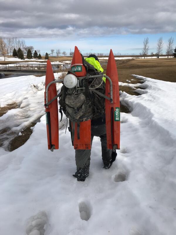
A USGS technician walks through snowy terrain carrying an ADCP device on his back during record Midwest flooding in spring 2019.
A USGS technician walks through snowy terrain carrying an ADCP device on his back during record Midwest flooding in spring 2019.

WWG Reading on the Wild Rice River in Minnesota during record Midwest flooding in spring 2019.
WWG Reading on the Wild Rice River in Minnesota during record Midwest flooding in spring 2019.

USGS streamgage number 13309220 on Idaho's Middle Fork of the Salmon River in the Frank Church River of No Return Wilderness Area.
USGS streamgage number 13309220 on Idaho's Middle Fork of the Salmon River in the Frank Church River of No Return Wilderness Area.

In Photo: Eastern berm of Jim Foot Key, April 2019. This photo taken from Florida Bay, looking in toward the center of the island (now covered in water). The arrow points toward a breach in the berm, first noted in 2014, but the cut has deepened significantly after Hurricane Irma, and the island interior
In Photo: Eastern berm of Jim Foot Key, April 2019. This photo taken from Florida Bay, looking in toward the center of the island (now covered in water). The arrow points toward a breach in the berm, first noted in 2014, but the cut has deepened significantly after Hurricane Irma, and the island interior

A coqui frog sits on a red ti leaf, next to a quarter for scale. Native to Puerto Rico, coqui frogs are an invasive species in Hawaii.
A coqui frog sits on a red ti leaf, next to a quarter for scale. Native to Puerto Rico, coqui frogs are an invasive species in Hawaii.

A coqui frog rests on a red ti plant leaf. Native to Puerto Rico, coqui are an invasive species in Hawaii.
A coqui frog rests on a red ti plant leaf. Native to Puerto Rico, coqui are an invasive species in Hawaii.

NW CASC’s USGS Director Nicole DeCrappeo on a recent rafting trip through the Grand Canyon on the Colorado River. She brought along a paper John Wesley Powell, an explorer and the 2nd director of the USGS, to commemorate the 150th anniversary of his historic trip down the Colorado River.
NW CASC’s USGS Director Nicole DeCrappeo on a recent rafting trip through the Grand Canyon on the Colorado River. She brought along a paper John Wesley Powell, an explorer and the 2nd director of the USGS, to commemorate the 150th anniversary of his historic trip down the Colorado River.

Northeast Region Photo Contest Winner | April 2019 | Honorable Mention
Esmeralda Vargas taking data on an estuary sample
Northeast Region Photo Contest Winner | April 2019 | Honorable Mention
Esmeralda Vargas taking data on an estuary sample