
Adaptive Management
Adaptive Management
Filter Total Items: 61

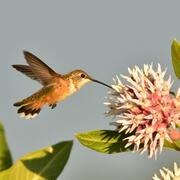
Synthesis of sage-grouse genetic information to support conservation and land management actions
Sage-grouse, iconic birds of the American West, have experienced dramatic reductions and fragmentation of habitat, resulting in significant conservation concern. Genetic information can help inform priorities for protection and habitat restoration as well as strategies for translocations, but may be difficult for resource managers to find, interpret, and use in their decision making. In this work...
KWIC Science: Rapid response products to meet resource managers’ priority science needs
Federal public land managers in the US are required by law to use science to inform management decisions. However, managers have limited time to identify science for use in decision making. Literature reviews are one tool to efficiently summarize science for use by managers, but are time-consuming to produce. Keyword in Context (KWIC) text analysis is a straightforward method of locating specific...
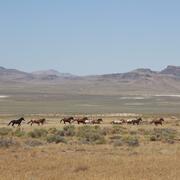
Science for management of America’s iconic wild horses and burros
Wild horses and burros are iconic wildlife of the western USA as well as a complicated management issue on tribal, state, and federal lands. Due to their history as domesticated animals, these wild equids – also called “free-roaming” or “feral” equids – can reproduce quickly, and have few natural predators, allowing their populations to grow rapidly if not managed. When populations are too large...

Data Harmonization for Greater Sage-Grouse Populations
Long-term wildlife monitoring is imperative for understanding population changes that can inform managers. However, working with population data collected by different organizations across multiple jurisdictions and over long time periods can be challenging due to varying data management approaches and organizational priorities. Through this project, we aimed to collaborate with eleven state...

Greater Sage-Grouse Population Monitoring Framework
Greater sage-grouse ( Centrocercus urophasianus) are at the center of state and national land use policies largely because of their unique life-history traits and their role as an ecological indicator for the health of sagebrush ecosystems. Multiple science centers with the U.S. Geological Survey (USGS) in conjunction with Colorado State University (CSU) have developed the Greater Sage-Grouse...

A user-friendly decision support tool for monitoring and managing greater sage-grouse populations
Researchers at the U.S. Geological Survey (USGS) and Colorado State University (CSU) collaborated with the Bureau of Land Management and state wildlife agencies to develop a hierarchical population monitoring framework for managing greater sage-grouse ( Centrocercus urophasianus) populations and the sagebrush ecosystems they depend on for survival and reproduction. This greater sage-grouse...

A targeted annual warning system (TAWS) for identifying aberrant declines in greater sage-grouse populations
Land and wildlife managers require accurate estimates of sensitive species’ trends to help guide conservation decisions that maintain biodiversity and promote healthy ecosystems. Multiple science centers with the U.S. Geological Survey (USGS), in conjunction with Colorado State University (CSU), developed a hierarchical population monitoring framework for managing greater sage-grouse (...

USGS Sagebrush Science: Supporting Public Safety and Economic Decision Making Across the West
The sagebrush biome is one of the largest ecosystems in North America. Encompassing nearly one-third of the continental U.S., it provides critical resources for millions of Americans and a home for hundreds of plants and animal species in the West. Natural resource management in sagebrush ecosystems can be complex, and science can support management decisions by providing knowledge and tools to...
By
Core Science Systems Mission Area, Ecosystems Mission Area, Biological Threats and Invasive Species Research Program, Climate Adaptation Science Centers, Cooperative Research Units, Land Management Research Program, Species Management Research Program, Earth Resources Observation and Science (EROS) Center, Forest and Rangeland Ecosystem Science Center, Fort Collins Science Center, Northern Rocky Mountain Science Center, Southwest Biological Science Center, Western Ecological Research Center (WERC), Wildland Fire Science
Recommendations for conducting landscape assessments to inform decision making on multiple-use public lands
Landscape assessments have been proposed as a mechanism for informing conservation and natural resource management actions at broad scales. We are documenting the process used in a large effort to conduct 14 such assessments across the western United States, and evaluating how the assessments were used in subsequent land use plans. In this project, we seek to identify methods and characteristics...

USGS Science Syntheses for Public Lands Management
Scientific information is fundamental to understanding how proposed actions on public lands may impact the environment. Development of new science is occurring at rates that can make it challenging for biologists, resource managers, decision makers, private landowners, and other stakeholders to ensure they are using up-to-date, high-quality science information to inform their decisions. Further...

Key Values of a Century of EESC Science
The USGS Eastern Ecological Science Center (EESC) is rooted in a proud tradition of service to the nation—advancing science that informs the conservation and management of fish, wildlife, and habitats across the eastern United States and beyond. Our mission is clear: deliver reliable, partner-driven science that supports natural resource decisions today, while ensuring these resources remain...

SBSC: Providing Unbiased Actionable Science & Information to Support Natural Resource Management Needs of the U.S. & Department of the Interior Priorities
The U.S. Geological Survey Southwest Biological Science Center (SBSC) is uniquely positioned in the Colorado River Basin to provide sound information, specialized expertise, and innovative tools to support the management and sustained use of natural resources on public and Tribal lands in the Southwest U.S.