Mapping biocrust with UAS technology in Moab, Utah
Mapping biocrust with UAS technology in Moab, UtahUSGS researchers teamed up for a biological soil crust (biocrust) remote sensing and field data campaign near Moab, Utah in February of 2022.


Official websites use .gov
A .gov website belongs to an official government organization in the United States.

Secure .gov websites use HTTPS
A lock () or https:// means you’ve safely connected to the .gov website. Share sensitive information only on official, secure websites.

The U.S. Geological Survey (USGS) National Uncrewed Systems Office (NUSO) leads the research activities needed to make Uncrewed Aircraft Systems (UAS) data collection an efficient, safe, and cost-effective remote sensing tool for Department of the Interior (DOI) and USGS scientists.
November 1, 2025
Drone-based radiometric surveys provide high-resolution mine waste characterization

We focus on the evaluation of new platforms, integration of new UAS-compatible sensors, development of data specifications and processing techniques, recommendations of UAS data acquisition best-practices, and operational support for new and existing DOI remote pilots.

We are a team of platform and UAS-compatible sensor subject matter experts that, in addition to research, provide operational support to DOI remote pilots and outreach to federal, public, and international audiences. Our office, established on May 8th, 2008, operates as part of the National Land Imaging Program, and contributes to its goal to provide the Federal Government and the public with the remotely sensed data and applications needed to support our Nation’s economic security and environmental vitality.

USGS researchers teamed up for a biological soil crust (biocrust) remote sensing and field data campaign near Moab, Utah in February of 2022.
USGS researchers teamed up for a biological soil crust (biocrust) remote sensing and field data campaign near Moab, Utah in February of 2022.

USGS scientists Joe Adams and Matt Burgess conduct a UAS lidar data collection flight at the Vicksburg National Military Park
NUSO scientists, along with USGS landslide researchers, in December 2022 undertook a topographic analysis of slide-prone areas of the National Park Service Vicksburg National Military Park near Vicksburg, Mississippi.
USGS scientists Joe Adams and Matt Burgess conduct a UAS lidar data collection flight at the Vicksburg National Military Park
NUSO scientists, along with USGS landslide researchers, in December 2022 undertook a topographic analysis of slide-prone areas of the National Park Service Vicksburg National Military Park near Vicksburg, Mississippi.

USGS employee Joe Adams positions a UAS over a calibration panel to capture a multispectral image with the attached MicaSense Dual multispectral sensor. This calibration image will be used to post-process the imagery in support of radiometric calibration research conducted at the Denver Federal Center in Colorado.
USGS employee Joe Adams positions a UAS over a calibration panel to capture a multispectral image with the attached MicaSense Dual multispectral sensor. This calibration image will be used to post-process the imagery in support of radiometric calibration research conducted at the Denver Federal Center in Colorado.

USGS NUSO scientists act as a visual observer (Joe Adams left) and a UAS remote pilot (Matt Burgess right) during a UAS flight at the Denver Federal Center
USGS NUSO scientists act as a visual observer (Joe Adams left) and a UAS remote pilot (Matt Burgess right) during a UAS flight at the Denver Federal Center

USGS employees from the USGS National Uncrewed Systems Office (NUSO) and the USGS EROS CalVal Center of Excellence (ECCOE) during a UAS test in a Denver Federal Center parking lot.
USGS employees from the USGS National Uncrewed Systems Office (NUSO) and the USGS EROS CalVal Center of Excellence (ECCOE) during a UAS test in a Denver Federal Center parking lot.

Permafrost is ground that has been frozen for at least two years. With the warming climate, permafrost across Alaska is thawing and greenhouse gases such as methane are released as a result. Ecologist Kristen Manies of the U.S.
Permafrost is ground that has been frozen for at least two years. With the warming climate, permafrost across Alaska is thawing and greenhouse gases such as methane are released as a result. Ecologist Kristen Manies of the U.S.

USGS researcher Victoria Scholl (NUSO) checks the image quality of photos captured using the Mavic Pro UAS over a bog in Alaska. These photos will be used to generate a Structure from Motion photogrammetry orthomosaic.
USGS researcher Victoria Scholl (NUSO) checks the image quality of photos captured using the Mavic Pro UAS over a bog in Alaska. These photos will be used to generate a Structure from Motion photogrammetry orthomosaic.
UAS carrying the methane sensor (left) and a smaller UAS used to collect videos and photos (right) in Alaska. Both UAS are resting on wooden pallets that the team set onto the bog for a dry and flat takeoff/landing location.
UAS carrying the methane sensor (left) and a smaller UAS used to collect videos and photos (right) in Alaska. Both UAS are resting on wooden pallets that the team set onto the bog for a dry and flat takeoff/landing location.

Victoria Scholl (NUSO), Kristen Manies (GMEG Science Center), and Joe Adams (NUSO) hiked the UAS gear through the woods and across a network of boardwalks to access the bog site at the BNZ LTER.
Victoria Scholl (NUSO), Kristen Manies (GMEG Science Center), and Joe Adams (NUSO) hiked the UAS gear through the woods and across a network of boardwalks to access the bog site at the BNZ LTER.

Image from a UAS acquired natural color video showing the UAS-mounted Kolibri sensor being flown through the smoke plume during one of the in-situ oil burns at a Poker Flat Research Range retention pond in Alaska.
Image from a UAS acquired natural color video showing the UAS-mounted Kolibri sensor being flown through the smoke plume during one of the in-situ oil burns at a Poker Flat Research Range retention pond in Alaska.

USGS researcher Joe Adams tacking down a calibration tarp at the Eastern Ecological Science Center - Leetown Research Laboratory.
USGS researcher Joe Adams tacking down a calibration tarp at the Eastern Ecological Science Center - Leetown Research Laboratory.
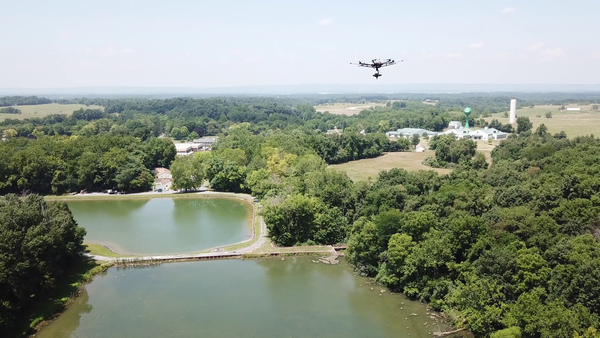
Uncrewed aircraft system (UAS) hyperspectral data collection flight over a reservoir at the Eastern USGS Eastern Ecological Science Center - Leetown Research Laboratory (EESC-LRL) in West Virginia.
Uncrewed aircraft system (UAS) hyperspectral data collection flight over a reservoir at the Eastern USGS Eastern Ecological Science Center - Leetown Research Laboratory (EESC-LRL) in West Virginia.

USGS researcher Matt Burgess remotely pilots a UAS collecting lidar data during the April 2022 USGS UASnow project at Berthoud Pass, Colorado.
USGS researcher Matt Burgess remotely pilots a UAS collecting lidar data during the April 2022 USGS UASnow project at Berthoud Pass, Colorado.

A UAS collecting natural color video over one of the study sites during a joint NUSO and USGS Water Resources Mission Area snow mapping project in Winter Park, Colorado.
A UAS collecting natural color video over one of the study sites during a joint NUSO and USGS Water Resources Mission Area snow mapping project in Winter Park, Colorado.

USGS NUSO researchers Victoria Scholl and Mark Bauer take a moment to enjoy the scenery during a UAS data collection for the snow water equivalent (SWE) project at the Berthoud Pass Colorado study site.
USGS NUSO researchers Victoria Scholl and Mark Bauer take a moment to enjoy the scenery during a UAS data collection for the snow water equivalent (SWE) project at the Berthoud Pass Colorado study site.

USGS researcher Joe Adams (NUSO) setting up a GPS base station at one of the study sites for a snow mapping project in Winter Park, Colorado. GPS base station data is used in post-processing to improve the geospatial accuracy of UAS collected data.
USGS researcher Joe Adams (NUSO) setting up a GPS base station at one of the study sites for a snow mapping project in Winter Park, Colorado. GPS base station data is used in post-processing to improve the geospatial accuracy of UAS collected data.

Please don’t walk on the biocrust!
Drone's eye view of a USGS remote pilot during a biocrust mission near Moab, UT
NUSO UAS pilot Matt Burgess captures an image of himself while landing a UAS after a flight over a biocrust site near Moab, Utah.
Drone's eye view of a USGS remote pilot during a biocrust mission near Moab, UT
NUSO UAS pilot Matt Burgess captures an image of himself while landing a UAS after a flight over a biocrust site near Moab, Utah.
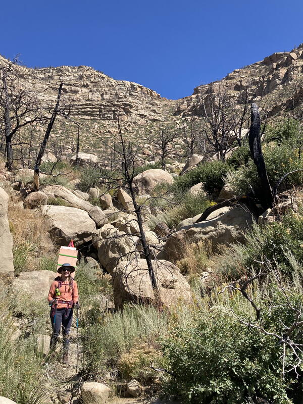
USGS researcher Victoria Scholl (NUSO) returns after collecting previously deployed scale bar and ground control point survey targets along the Paleocene Poison Canyon Formation in the Cimarron Canyon, New Mexico.
USGS researcher Victoria Scholl (NUSO) returns after collecting previously deployed scale bar and ground control point survey targets along the Paleocene Poison Canyon Formation in the Cimarron Canyon, New Mexico.

USGS scientist Victoria Scholl (NUSO) places a scale bar and ground control point survey target along the Paleocene Poison Canyon Formation in the Cimarron Canyon. GPS data from these targets and derived from the UAS collected imagery helps ensure high positional and geometric accuracy of georeferenced data products including 3D models.
USGS scientist Victoria Scholl (NUSO) places a scale bar and ground control point survey target along the Paleocene Poison Canyon Formation in the Cimarron Canyon. GPS data from these targets and derived from the UAS collected imagery helps ensure high positional and geometric accuracy of georeferenced data products including 3D models.

UAS ground control point survey targets deployed along the Cimarron Canyon in New Mexico
One of the ground control point survey targets deployed along the Paleocene Poison Canyon Formation in the Cimarron Canyon and used to provide accurate GPS data during the UAS data collection flights.
UAS ground control point survey targets deployed along the Cimarron Canyon in New Mexico
One of the ground control point survey targets deployed along the Paleocene Poison Canyon Formation in the Cimarron Canyon and used to provide accurate GPS data during the UAS data collection flights.
The U.S. Geological Survey (USGS) National Uncrewed Systems Office (NUSO) leads the research activities needed to make Uncrewed Aircraft Systems (UAS) data collection an efficient, safe, and cost-effective remote sensing tool for Department of the Interior (DOI) and USGS scientists.
November 1, 2025
Drone-based radiometric surveys provide high-resolution mine waste characterization
We focus on the evaluation of new platforms, integration of new UAS-compatible sensors, development of data specifications and processing techniques, recommendations of UAS data acquisition best-practices, and operational support for new and existing DOI remote pilots.
We are a team of platform and UAS-compatible sensor subject matter experts that, in addition to research, provide operational support to DOI remote pilots and outreach to federal, public, and international audiences. Our office, established on May 8th, 2008, operates as part of the National Land Imaging Program, and contributes to its goal to provide the Federal Government and the public with the remotely sensed data and applications needed to support our Nation’s economic security and environmental vitality.
USGS researchers teamed up for a biological soil crust (biocrust) remote sensing and field data campaign near Moab, Utah in February of 2022.
USGS researchers teamed up for a biological soil crust (biocrust) remote sensing and field data campaign near Moab, Utah in February of 2022.
USGS scientists Joe Adams and Matt Burgess conduct a UAS lidar data collection flight at the Vicksburg National Military Park
NUSO scientists, along with USGS landslide researchers, in December 2022 undertook a topographic analysis of slide-prone areas of the National Park Service Vicksburg National Military Park near Vicksburg, Mississippi.
USGS scientists Joe Adams and Matt Burgess conduct a UAS lidar data collection flight at the Vicksburg National Military Park
NUSO scientists, along with USGS landslide researchers, in December 2022 undertook a topographic analysis of slide-prone areas of the National Park Service Vicksburg National Military Park near Vicksburg, Mississippi.
USGS employee Joe Adams positions a UAS over a calibration panel to capture a multispectral image with the attached MicaSense Dual multispectral sensor. This calibration image will be used to post-process the imagery in support of radiometric calibration research conducted at the Denver Federal Center in Colorado.
USGS employee Joe Adams positions a UAS over a calibration panel to capture a multispectral image with the attached MicaSense Dual multispectral sensor. This calibration image will be used to post-process the imagery in support of radiometric calibration research conducted at the Denver Federal Center in Colorado.
USGS NUSO scientists act as a visual observer (Joe Adams left) and a UAS remote pilot (Matt Burgess right) during a UAS flight at the Denver Federal Center
USGS NUSO scientists act as a visual observer (Joe Adams left) and a UAS remote pilot (Matt Burgess right) during a UAS flight at the Denver Federal Center
USGS employees from the USGS National Uncrewed Systems Office (NUSO) and the USGS EROS CalVal Center of Excellence (ECCOE) during a UAS test in a Denver Federal Center parking lot.
USGS employees from the USGS National Uncrewed Systems Office (NUSO) and the USGS EROS CalVal Center of Excellence (ECCOE) during a UAS test in a Denver Federal Center parking lot.
Permafrost is ground that has been frozen for at least two years. With the warming climate, permafrost across Alaska is thawing and greenhouse gases such as methane are released as a result. Ecologist Kristen Manies of the U.S.
Permafrost is ground that has been frozen for at least two years. With the warming climate, permafrost across Alaska is thawing and greenhouse gases such as methane are released as a result. Ecologist Kristen Manies of the U.S.
USGS researcher Victoria Scholl (NUSO) checks the image quality of photos captured using the Mavic Pro UAS over a bog in Alaska. These photos will be used to generate a Structure from Motion photogrammetry orthomosaic.
USGS researcher Victoria Scholl (NUSO) checks the image quality of photos captured using the Mavic Pro UAS over a bog in Alaska. These photos will be used to generate a Structure from Motion photogrammetry orthomosaic.
UAS carrying the methane sensor (left) and a smaller UAS used to collect videos and photos (right) in Alaska. Both UAS are resting on wooden pallets that the team set onto the bog for a dry and flat takeoff/landing location.
UAS carrying the methane sensor (left) and a smaller UAS used to collect videos and photos (right) in Alaska. Both UAS are resting on wooden pallets that the team set onto the bog for a dry and flat takeoff/landing location.
Victoria Scholl (NUSO), Kristen Manies (GMEG Science Center), and Joe Adams (NUSO) hiked the UAS gear through the woods and across a network of boardwalks to access the bog site at the BNZ LTER.
Victoria Scholl (NUSO), Kristen Manies (GMEG Science Center), and Joe Adams (NUSO) hiked the UAS gear through the woods and across a network of boardwalks to access the bog site at the BNZ LTER.
Image from a UAS acquired natural color video showing the UAS-mounted Kolibri sensor being flown through the smoke plume during one of the in-situ oil burns at a Poker Flat Research Range retention pond in Alaska.
Image from a UAS acquired natural color video showing the UAS-mounted Kolibri sensor being flown through the smoke plume during one of the in-situ oil burns at a Poker Flat Research Range retention pond in Alaska.
USGS researcher Joe Adams tacking down a calibration tarp at the Eastern Ecological Science Center - Leetown Research Laboratory.
USGS researcher Joe Adams tacking down a calibration tarp at the Eastern Ecological Science Center - Leetown Research Laboratory.
Uncrewed aircraft system (UAS) hyperspectral data collection flight over a reservoir at the Eastern USGS Eastern Ecological Science Center - Leetown Research Laboratory (EESC-LRL) in West Virginia.
Uncrewed aircraft system (UAS) hyperspectral data collection flight over a reservoir at the Eastern USGS Eastern Ecological Science Center - Leetown Research Laboratory (EESC-LRL) in West Virginia.
USGS researcher Matt Burgess remotely pilots a UAS collecting lidar data during the April 2022 USGS UASnow project at Berthoud Pass, Colorado.
USGS researcher Matt Burgess remotely pilots a UAS collecting lidar data during the April 2022 USGS UASnow project at Berthoud Pass, Colorado.
A UAS collecting natural color video over one of the study sites during a joint NUSO and USGS Water Resources Mission Area snow mapping project in Winter Park, Colorado.
A UAS collecting natural color video over one of the study sites during a joint NUSO and USGS Water Resources Mission Area snow mapping project in Winter Park, Colorado.
USGS NUSO researchers Victoria Scholl and Mark Bauer take a moment to enjoy the scenery during a UAS data collection for the snow water equivalent (SWE) project at the Berthoud Pass Colorado study site.
USGS NUSO researchers Victoria Scholl and Mark Bauer take a moment to enjoy the scenery during a UAS data collection for the snow water equivalent (SWE) project at the Berthoud Pass Colorado study site.
USGS researcher Joe Adams (NUSO) setting up a GPS base station at one of the study sites for a snow mapping project in Winter Park, Colorado. GPS base station data is used in post-processing to improve the geospatial accuracy of UAS collected data.
USGS researcher Joe Adams (NUSO) setting up a GPS base station at one of the study sites for a snow mapping project in Winter Park, Colorado. GPS base station data is used in post-processing to improve the geospatial accuracy of UAS collected data.
Please don’t walk on the biocrust!
Drone's eye view of a USGS remote pilot during a biocrust mission near Moab, UT
NUSO UAS pilot Matt Burgess captures an image of himself while landing a UAS after a flight over a biocrust site near Moab, Utah.
Drone's eye view of a USGS remote pilot during a biocrust mission near Moab, UT
NUSO UAS pilot Matt Burgess captures an image of himself while landing a UAS after a flight over a biocrust site near Moab, Utah.
USGS researcher Victoria Scholl (NUSO) returns after collecting previously deployed scale bar and ground control point survey targets along the Paleocene Poison Canyon Formation in the Cimarron Canyon, New Mexico.
USGS researcher Victoria Scholl (NUSO) returns after collecting previously deployed scale bar and ground control point survey targets along the Paleocene Poison Canyon Formation in the Cimarron Canyon, New Mexico.
USGS scientist Victoria Scholl (NUSO) places a scale bar and ground control point survey target along the Paleocene Poison Canyon Formation in the Cimarron Canyon. GPS data from these targets and derived from the UAS collected imagery helps ensure high positional and geometric accuracy of georeferenced data products including 3D models.
USGS scientist Victoria Scholl (NUSO) places a scale bar and ground control point survey target along the Paleocene Poison Canyon Formation in the Cimarron Canyon. GPS data from these targets and derived from the UAS collected imagery helps ensure high positional and geometric accuracy of georeferenced data products including 3D models.
UAS ground control point survey targets deployed along the Cimarron Canyon in New Mexico
One of the ground control point survey targets deployed along the Paleocene Poison Canyon Formation in the Cimarron Canyon and used to provide accurate GPS data during the UAS data collection flights.
UAS ground control point survey targets deployed along the Cimarron Canyon in New Mexico
One of the ground control point survey targets deployed along the Paleocene Poison Canyon Formation in the Cimarron Canyon and used to provide accurate GPS data during the UAS data collection flights.