
In the winter of 2015, the public noticed thousands of dead seabirds washing ashore across the western coast of the United States and Canada. The USGS linked this massive seabird die-off to the North Pacific Marine Heatwave. A marine heatwave occurs when sea surface temperatures are above normal for an extended period of time.
Marine Biology and Ecosystems
California Sea Otter Surveys and Research
Coral Reef Project
Aerial Seabird and Marine Mammal Surveys
CASC Fish Research
The ocean is home to a wealth of biodiversity - from invisible-to-the-eye microbes to the larger-than-life megafauna - and unique marine habitat, such as deepwater coral reefs, seamounts, and submarine canyons. USGS science helps inform the management and conservation of marine biodiversity and habitats, from the coastlines down to the deepest trench.
Life in the Sea
From the microscopic plants known as phytoplankton that form the basis of the aquatic food web to the largest animal to ever live on Earth, the blue whale, our oceans are home to a wealth of biodiversity and every organism plays a critical role in the structure and function of this expansive marine environment.


Sources/Usage: Public Domain. View Media Details
Maintaining this biodiversity is important because a healthy ocean provides us with oxygen, helps regulate climate and weather, acts as a source of protein for many people around the world, and provides jobs and opportunities for eco-tourism and recreation. USGS science informs the management and conservation of marine biodiversity and habitats, in both nearshore and deepwater ecosystems.
USGS Role in Marine Ecosystems Research
From the Atlantic to the Pacific and the Gulf Region in between, USGS scientists have implemented a multi-faceted offshore research program that weaves together expertise in a variety of disciplines to investigate nearshore and deepwater ecosystems. This interdisciplinary approach relies on a network of partners from around the Nation and the world to examine microbiology, population genetics, paleoecology, food webs, taxonomy, community ecology, physical oceanography, seafloor characteristics, and submarine hazards in the little explored, yet vital, marine ecosystems.
Media

Wildlife disease: Much like terrestrial species, animals in the ocean have to worry about the spread of disease. USGS scientists across the Nation are working together with various federal and state partners to assess and better understand a novel coral disease that first appeared in stony corals off the coast of Florida in 2014 and has now spread throughout the Caribbean. In Hawaii, USGS scientists are studying the cause and spread of fibropapillomatosis, a disease that leads to tumors growing internally and externally on sea turtles.
Sources/Usage: Public Domain. View Media Details
Media

Wildlife tracking: Understanding the short- and long-distance movements of wildlife, particularly those species that spend most of their life offshore and/or underwater, is critical for a wide variety of ecological research questions and management decisions. The USGS tags and tracks imperiled marine species, such as sea otters, sea turtles, and seabirds to learn about their behavior, migration patterns, and habitat use and areas of high use. This information can help inform the creation of marine protected areas or the development of species management strategies. Several aquatic animals, such as manatees or fishes like Chinook salmon and river herring, can move between fresh and salt water. Tracking their movement can reveal connections between marine and coastal ecosystems and provide insight into the seasonality of mass migrations.
Sources/Usage: Public Domain. View Media Details
Media

Satellite tracking: The satellite tracking map (yellow lines show satellite locations over time) of a loggerhead sea turtle tagged in Florida Keys National Marine Sanctuary. The male turtle traveled to Palm Beach County, Florida for a probable breeding foray during March of 2020.
Sources/Usage: Public Domain. View Media Details
USGS Science in Nearshore Ecosystems
Nearshore systems are the habitats in which most people interact with marine environments, which include seabirds, seagrasses, algae, benthic invertebrates and fish, and top predators that include marine mammals like sharks, sea otters, walruses, and even polar bears. USGS research addresses natural and human-induced changes to this ecosystem and all its components.
Media

Sources/Usage: Public Domain. View Media Details
Exploring Deep-sea Ecosystems
Most life in the ocean exists in surface waters above 200 meters depth where they have access to sunlight. However, even below 200 meters, where little to no sunlight reaches, temperatures drop, and pressure increases, abundant life exists. A diversity of organisms, including fishes, crustaceans, cephalopods, anemones, sea stars, microbes, and even corals make their home in the deep sea. These organisms reside on topographically complex terrain mirroring our terrestrial landscape, dotted with features like trenches, seamounts, canyons, and volcanoes. They also leave behind fossils that help geoscientists construct models of ancient ocean conditions and Earth’s geologic history, as shown in the schematic below.
Media

Sources/Usage: Public Domain. View Media Details
Life at the Bottom of the Ocean
The mention of the seafloor may evoke thoughts of a deep, dark expanse of nothing, but the often-assumed void of life in the deep sea couldn’t be further from the truth. Even with the lack of sunlight, an average temperature of 4 degrees Celsius, and extreme pressures that an unprotected human could not survive, the deep sea is brimming with biodiversity, including deep-sea corals. The DISCOVRE (DIversity, Systematics and COnnectivity of Vulnerable Reef Ecosystems) program investigates unique and fragile deep-sea coral environments from the microscopic level to the ecosystem level. The multi-disciplinary approach has enhanced our understanding of the structure and function of significant biological communities surrounding deep coral reefs off the United States’ coasts.
Media

Sources/Usage: Public Domain. View Media Details
Science

North Pacific Pelagic Seabird Database
The North Pacific Pelagic Seabird Database (NPPSD) contains survey transect data designed and conducted by numerous partners primarily to census seabirds at sea. The NPPSD includes more than 486,000 transect segments and includes observations of over 20 million birds of 258 species collected over the span of 50 years (from 1973 to 2022).

Seabirds and Forage Fish Ecology
Alaska's coastal and offshore waters provide foraging habitat for an estimated 100 million birds comprising more than 90 different species; from loons and seaducks that nest inland, to petrels and puffins that breed on islands off shore. All these birds depend on the sea to provide a wide variety of food types— from clams, crabs and urchins nearshore— to krill, forage fish, and squid offshore. The...

Polar Bear Research
Polar bears ( Ursus maritimus) are one of 4 marine mammal species managed by the U.S. Department of Interior. The USGS Alaska Science Center leads long–term research on polar bears to inform local, state, national and international policy makers regarding conservation of the species and its habitat. Our studies, ongoing since 1985, are focused on population dynamics, health and energetics...

Nearshore Marine Ecosystem Research
Nearshore ecosystems include many resources that are of high ecological, recreational, subsistence, and economic value. They also are subject to influences from a wide variety of natural and human-caused perturbations, which can originate in terrestrial or oceanic environments. Our research is designed to evaluate sources of variation in the nearshore and how they influence resources of high...

Tracking Data for Tufted Puffins (Fratercula cirrhata)
Available here are tracking data for the tufted puffin, a seabird species that is found only in coastal and offshore areas of the North Pacific Ocean. These data were collected to better understand the migratory patterns of tufted puffins that breed in the Aleutian Islands.
Multimedia

North Pacific Marine Heatwave
In the winter of 2015, the public noticed thousands of dead seabirds washing ashore across the western coast of the United States and Canada. The USGS linked this massive seabird die-off to the North Pacific Marine Heatwave. A marine heatwave occurs when sea surface temperatures are above normal for an extended period of time.

Argos Wildlife Tracking Common Eiders - animation
Illustrates where Common Eiders were tracked using Argos Wildlife Tracking.
Illustrates where Common Eiders were tracked using Argos Wildlife Tracking.

Seabirds and Marine Mammals Photographed During Aerial Surveys

Tufted Puffins on the water, Alaska
Four Tufted Puffins on the water, near their breeding colony at Gull Island in Kachemak Bay, Alaska
Four Tufted Puffins on the water, near their breeding colony at Gull Island in Kachemak Bay, Alaska

Fin Whale (Balaenoptera physalus) breaking the surface
Fin Whale (Balaenoptera physalus) breaking the surfaceZoomed image of a Fin Whale (Balaenoptera physalus) breaking the surface.
Fin Whale (Balaenoptera physalus) breaking the surface
Fin Whale (Balaenoptera physalus) breaking the surfaceZoomed image of a Fin Whale (Balaenoptera physalus) breaking the surface.
Fin Whale (Balaenoptera physalus) breaking the surface
Fin Whale (Balaenoptera physalus) breaking the surfaceZoomed image of a Fin Whale (Balaenoptera physalus) breaking the surface.
Fin Whale (Balaenoptera physalus) breaking the surface
Fin Whale (Balaenoptera physalus) breaking the surfaceZoomed image of a Fin Whale (Balaenoptera physalus) breaking the surface.

Argos Wildlife Tracking Pelagic Cormorants - animation
Argos Wildlife Tracking Pelagic Cormorants - animationIllustrates where Pelagic Cormorants were tracked using Argos Wildlife Tracking.
Argos Wildlife Tracking Pelagic Cormorants - animation
Argos Wildlife Tracking Pelagic Cormorants - animationIllustrates where Pelagic Cormorants were tracked using Argos Wildlife Tracking.
Argos Wildlife Tracking Pelagic Cormorants - animation
Argos Wildlife Tracking Pelagic Cormorants - animationIllustrates where Pelagic Cormorants were tracked using Argos Wildlife Tracking.
Argos Wildlife Tracking Pelagic Cormorants - animation
Argos Wildlife Tracking Pelagic Cormorants - animationIllustrates where Pelagic Cormorants were tracked using Argos Wildlife Tracking.

Argos Wildlife Tracking Tufted Puffin animation
Illustrates where Tufted Puffins were tracked using Argos Wildlife Tracking
Illustrates where Tufted Puffins were tracked using Argos Wildlife Tracking
Filter Total Items: 55
North Pacific Pelagic Seabird Database
The North Pacific Pelagic Seabird Database (NPPSD) contains survey transect data designed and conducted by numerous partners primarily to census seabirds at sea. The NPPSD includes more than 486,000 transect segments and includes observations of over 20 million birds of 258 species collected over the span of 50 years (from 1973 to 2022).
Seabirds and Forage Fish Ecology
Alaska's coastal and offshore waters provide foraging habitat for an estimated 100 million birds comprising more than 90 different species; from loons and seaducks that nest inland, to petrels and puffins that breed on islands off shore. All these birds depend on the sea to provide a wide variety of food types— from clams, crabs and urchins nearshore— to krill, forage fish, and squid offshore. The...
Polar Bear Research
Polar bears ( Ursus maritimus) are one of 4 marine mammal species managed by the U.S. Department of Interior. The USGS Alaska Science Center leads long–term research on polar bears to inform local, state, national and international policy makers regarding conservation of the species and its habitat. Our studies, ongoing since 1985, are focused on population dynamics, health and energetics...
Nearshore Marine Ecosystem Research
Nearshore ecosystems include many resources that are of high ecological, recreational, subsistence, and economic value. They also are subject to influences from a wide variety of natural and human-caused perturbations, which can originate in terrestrial or oceanic environments. Our research is designed to evaluate sources of variation in the nearshore and how they influence resources of high...
Tracking Data for Tufted Puffins (Fratercula cirrhata)
Available here are tracking data for the tufted puffin, a seabird species that is found only in coastal and offshore areas of the North Pacific Ocean. These data were collected to better understand the migratory patterns of tufted puffins that breed in the Aleutian Islands.

Tracking Data for Pelagic Cormorants (Phalacrocorax pelagicus)
Available here are tracking data for the pelagic cormorant, a seabird species that breeds throughout the northern Pacific Ocean and spends the winter in East Asia and throughout costal portions of western North America. These data were collected to better understand the migratory patterns of Pelagic cormorants that breed in southeast Alaska.

Walrus Research
The USGS Alaska Science Center conducts long-term research on the Pacific walrus to provide scientific information to Department of Interior management agencies and Alaska Native co-management partners. In addition, the USGS Pacific walrus research program collaborates with the U.S. Fish and Wildlife Service (USFWS) and the State of Alaska’s Department of Fish and Game and Alaska Native co...

Controls on habitat for native lamprey in the Siletz River Basin
Chinook Salmon and Pacific Lamprey are culturally significant fishes to the Tribal community along the Siletz River, Oregon. The USGS studied how streamflow and bedload conditions may influence mainstem spawning habitats.

Changing Arctic Ecosystems
Arctic regions of Alaska are important for cultural and economic sustainability and host a wide variety of wildlife species, many of which are of conservation and management interest to the U.S. Department of the Interior. The USGS and collaborators provide information about Arctic ecosystems that are used by Arctic residents, management agencies, and industry.

Fish & Wildlife Disease: Coral Diseases and Reef Health
Corals reefs support marine biodiversity, protect coastlines from storm surges and strong waves, and provide income from tourism to coastal communities. Coral diseases were first recognized in the 1970s and are now considered a major threat to coral reef survival worldwide. Stony coral tissue loss disease (SCTLD) emerged in Florida in 2014, impacting coral reefs in Florida, Puerto Rico, US Virgin...

Mesophotic and Deep Benthic Communities: Coral Propagation Technique (CPT) Development Project
Through a collaborative effort with other federal agencies and academic and research institutions, the USGS is working to inform and enhance the protection and management of coral communities in mesophotic and deep benthic areas of the Gulf.

USGS DISCOVRE: Benthic Ecology, Trophodynamics, and Ecosystem Connectivity – Lophelia II: Continuing Ecological Research on Deep-Sea Corals and Deep Reef Habitats in the Gulf
Deep-sea coral habitats are complex ecosystems at the landscape and local level. While these systems may harbor substantial levels of biodiversity, they remain inadequately investigated.
Filter Total Items: 29
North Pacific Marine Heatwave
In the winter of 2015, the public noticed thousands of dead seabirds washing ashore across the western coast of the United States and Canada. The USGS linked this massive seabird die-off to the North Pacific Marine Heatwave. A marine heatwave occurs when sea surface temperatures are above normal for an extended period of time.
In the winter of 2015, the public noticed thousands of dead seabirds washing ashore across the western coast of the United States and Canada. The USGS linked this massive seabird die-off to the North Pacific Marine Heatwave. A marine heatwave occurs when sea surface temperatures are above normal for an extended period of time.
Argos Wildlife Tracking Common Eiders - animation
Illustrates where Common Eiders were tracked using Argos Wildlife Tracking.
Illustrates where Common Eiders were tracked using Argos Wildlife Tracking.
Seabirds and Marine Mammals Photographed During Aerial Surveys
Tufted Puffins on the water, Alaska
Four Tufted Puffins on the water, near their breeding colony at Gull Island in Kachemak Bay, Alaska
Four Tufted Puffins on the water, near their breeding colony at Gull Island in Kachemak Bay, Alaska
Fin Whale (Balaenoptera physalus) breaking the surface
Fin Whale (Balaenoptera physalus) breaking the surfaceZoomed image of a Fin Whale (Balaenoptera physalus) breaking the surface.
Fin Whale (Balaenoptera physalus) breaking the surface
Fin Whale (Balaenoptera physalus) breaking the surfaceZoomed image of a Fin Whale (Balaenoptera physalus) breaking the surface.
Fin Whale (Balaenoptera physalus) breaking the surface
Fin Whale (Balaenoptera physalus) breaking the surfaceZoomed image of a Fin Whale (Balaenoptera physalus) breaking the surface.
Fin Whale (Balaenoptera physalus) breaking the surface
Fin Whale (Balaenoptera physalus) breaking the surfaceZoomed image of a Fin Whale (Balaenoptera physalus) breaking the surface.
Argos Wildlife Tracking Pelagic Cormorants - animation
Argos Wildlife Tracking Pelagic Cormorants - animationIllustrates where Pelagic Cormorants were tracked using Argos Wildlife Tracking.
Argos Wildlife Tracking Pelagic Cormorants - animation
Argos Wildlife Tracking Pelagic Cormorants - animationIllustrates where Pelagic Cormorants were tracked using Argos Wildlife Tracking.
Argos Wildlife Tracking Pelagic Cormorants - animation
Argos Wildlife Tracking Pelagic Cormorants - animationIllustrates where Pelagic Cormorants were tracked using Argos Wildlife Tracking.
Argos Wildlife Tracking Pelagic Cormorants - animation
Argos Wildlife Tracking Pelagic Cormorants - animationIllustrates where Pelagic Cormorants were tracked using Argos Wildlife Tracking.
Argos Wildlife Tracking Tufted Puffin animation
Illustrates where Tufted Puffins were tracked using Argos Wildlife Tracking
Illustrates where Tufted Puffins were tracked using Argos Wildlife Tracking
Argos Wildlife Tracking Tufted Puffin animation
Illustrates where Tufted Puffins were tracked using Argos Wildlife Tracking
Illustrates where Tufted Puffins were tracked using Argos Wildlife Tracking
Argos Wildlife Tracking Northern Fulmar animation
Illustrates where Northern Fulmars were tracked using Argos Wildlife Tracking.
Illustrates where Northern Fulmars were tracked using Argos Wildlife Tracking.

Timing is Everything: Fish, Wildlife, and Timing of Life Events
Timing is Everything: Fish, Wildlife, and Timing of Life EventsTiming is Everything: How Fish and Wildlife are Responding to Climate Change Through Shifts in the Timing of Life Events
Timing is Everything: Fish, Wildlife, and Timing of Life Events
Timing is Everything: Fish, Wildlife, and Timing of Life EventsTiming is Everything: How Fish and Wildlife are Responding to Climate Change Through Shifts in the Timing of Life Events

Red plumes burst out from the tops of these chemosynthetic tubeworms
Red plumes burst out from the tops of these chemosynthetic tubewormsRed plumes burst out from the tops of these chemosynthetic tubeworms, capturing hydrogen sulfide and oxygen from the surrounding water to feed their bacterial endosymbionts. The tubeworm tubes provide a habitat for several benthic animals, including the pale pink branching octocorals seen here

Pom-pom anemone on the Pacific Ocean floor off California
Pom-pom anemone on the Pacific Ocean floor off CaliforniaThese “pom-pom” anemones (Liponema sp.) have attached to the rock in a place where there are probably very good currents, which bring small floating particles of food to them. Water depth is 1041 m (3415 ft).

Sea life offshore of Morro Bay, California
A small juvenile skate (left) and a large rockfish (right) hang out on the murky, silty seafloor with sea stars. Water depth: 856 m (2808 ft).
A small juvenile skate (left) and a large rockfish (right) hang out on the murky, silty seafloor with sea stars. Water depth: 856 m (2808 ft).

Sea Turtle Underwater POV
See St. Joseph Bay in the Florida Panhandle through the eyes of two young adult female loggerheads as they swim, surface to breathe, dive, forage on underwater grasses and spend time with other sea turtles. Three species of threatened or endangered sea turtles congregate in St. Joseph Bay.
See St. Joseph Bay in the Florida Panhandle through the eyes of two young adult female loggerheads as they swim, surface to breathe, dive, forage on underwater grasses and spend time with other sea turtles. Three species of threatened or endangered sea turtles congregate in St. Joseph Bay.
Releasing a loggerhead with radio tag
A loggerhead sea turtle, outfitted with a popoff ADL package (orange item on the turtle’s back), is released by New England Aquarium Biologist Nick Whitney.
A loggerhead sea turtle, outfitted with a popoff ADL package (orange item on the turtle’s back), is released by New England Aquarium Biologist Nick Whitney.
Loggerhead sea turtle with radio tag
Underwater view of a loggerhead turtle being released with newly installed popoff ADL package (orange item on turtle’s back).
Underwater view of a loggerhead turtle being released with newly installed popoff ADL package (orange item on turtle’s back).

Horned Puffin, near Chisik Island in Lower Cook Inlet, Alaska
Horned Puffin, near Chisik Island in Lower Cook Inlet, AlaskaHorned Puffin, one of the species affected by a recent seabird die-off in the Pribilof Islands, AK. Near Chisik Island in Lower Cook Inlet, Alaska
Horned Puffin, near Chisik Island in Lower Cook Inlet, Alaska
Horned Puffin, near Chisik Island in Lower Cook Inlet, AlaskaHorned Puffin, one of the species affected by a recent seabird die-off in the Pribilof Islands, AK. Near Chisik Island in Lower Cook Inlet, Alaska

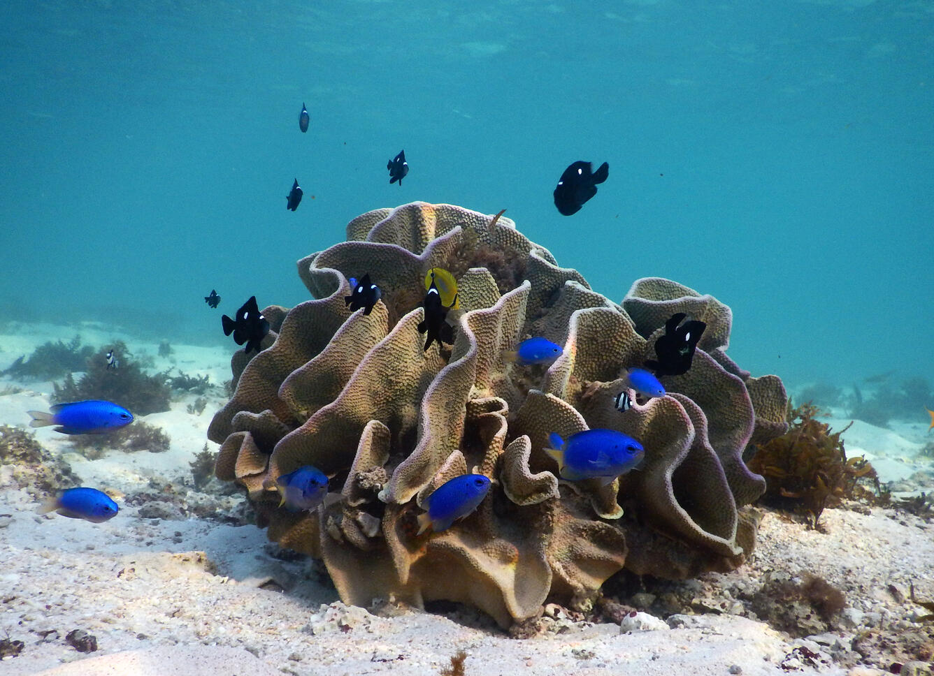
Lettuce coral with cerulean and domino damselfish
Cerulean damselfish dart around lettuce coral off the Cape Range National Park along the Ningaloo Coast in Western Australia. USGS researchers combined forces with Australian colleagues in this UNESCO World Heritage Site to conduct the most extensive study of how erosion of reefs contribute sand to the beaches—a coast’s natural armor.
Cerulean damselfish dart around lettuce coral off the Cape Range National Park along the Ningaloo Coast in Western Australia. USGS researchers combined forces with Australian colleagues in this UNESCO World Heritage Site to conduct the most extensive study of how erosion of reefs contribute sand to the beaches—a coast’s natural armor.

Why are coral reefs in peril and what is being done to protect them? Why are coral reefs in peril and what is being done to protect them?
Coral reefs can be damaged by natural processes, such as storms, but they are increasingly at risk from human activities. Oil spills and pollutants can threaten entire reefs. Excessive nutrients from land sources, such as sewage and agricultural fertilizers, promote the growth of algae that can smother corals. Other organisms harmful to corals, such as crown-of-thorns starfish, multiply when the...

How do salmon know where their home is when they return from the ocean? How do salmon know where their home is when they return from the ocean?
Salmon come back to the stream where they were 'born' because they 'know' it is a good place to spawn; they won't waste time looking for a stream with good habitat and other salmon. Scientists believe that salmon navigate by using the earth’s magnetic field like a compass. When they find the river they came from, they start using smell to find their way back to their home stream. They build their...
The ocean is home to a wealth of biodiversity - from invisible-to-the-eye microbes to the larger-than-life megafauna - and unique marine habitat, such as deepwater coral reefs, seamounts, and submarine canyons. USGS science helps inform the management and conservation of marine biodiversity and habitats, from the coastlines down to the deepest trench.
Life in the Sea
From the microscopic plants known as phytoplankton that form the basis of the aquatic food web to the largest animal to ever live on Earth, the blue whale, our oceans are home to a wealth of biodiversity and every organism plays a critical role in the structure and function of this expansive marine environment.
Sources/Usage: Public Domain. View Media Details
Maintaining this biodiversity is important because a healthy ocean provides us with oxygen, helps regulate climate and weather, acts as a source of protein for many people around the world, and provides jobs and opportunities for eco-tourism and recreation. USGS science informs the management and conservation of marine biodiversity and habitats, in both nearshore and deepwater ecosystems.
USGS Role in Marine Ecosystems Research
From the Atlantic to the Pacific and the Gulf Region in between, USGS scientists have implemented a multi-faceted offshore research program that weaves together expertise in a variety of disciplines to investigate nearshore and deepwater ecosystems. This interdisciplinary approach relies on a network of partners from around the Nation and the world to examine microbiology, population genetics, paleoecology, food webs, taxonomy, community ecology, physical oceanography, seafloor characteristics, and submarine hazards in the little explored, yet vital, marine ecosystems.
Media
Wildlife disease: Much like terrestrial species, animals in the ocean have to worry about the spread of disease. USGS scientists across the Nation are working together with various federal and state partners to assess and better understand a novel coral disease that first appeared in stony corals off the coast of Florida in 2014 and has now spread throughout the Caribbean. In Hawaii, USGS scientists are studying the cause and spread of fibropapillomatosis, a disease that leads to tumors growing internally and externally on sea turtles.
Sources/Usage: Public Domain. View Media Details
Media
Wildlife tracking: Understanding the short- and long-distance movements of wildlife, particularly those species that spend most of their life offshore and/or underwater, is critical for a wide variety of ecological research questions and management decisions. The USGS tags and tracks imperiled marine species, such as sea otters, sea turtles, and seabirds to learn about their behavior, migration patterns, and habitat use and areas of high use. This information can help inform the creation of marine protected areas or the development of species management strategies. Several aquatic animals, such as manatees or fishes like Chinook salmon and river herring, can move between fresh and salt water. Tracking their movement can reveal connections between marine and coastal ecosystems and provide insight into the seasonality of mass migrations.
Sources/Usage: Public Domain. View Media Details
Media
Satellite tracking: The satellite tracking map (yellow lines show satellite locations over time) of a loggerhead sea turtle tagged in Florida Keys National Marine Sanctuary. The male turtle traveled to Palm Beach County, Florida for a probable breeding foray during March of 2020.
Sources/Usage: Public Domain. View Media Details
USGS Science in Nearshore Ecosystems
Nearshore systems are the habitats in which most people interact with marine environments, which include seabirds, seagrasses, algae, benthic invertebrates and fish, and top predators that include marine mammals like sharks, sea otters, walruses, and even polar bears. USGS research addresses natural and human-induced changes to this ecosystem and all its components.
Media
Sources/Usage: Public Domain. View Media Details
Exploring Deep-sea Ecosystems
Most life in the ocean exists in surface waters above 200 meters depth where they have access to sunlight. However, even below 200 meters, where little to no sunlight reaches, temperatures drop, and pressure increases, abundant life exists. A diversity of organisms, including fishes, crustaceans, cephalopods, anemones, sea stars, microbes, and even corals make their home in the deep sea. These organisms reside on topographically complex terrain mirroring our terrestrial landscape, dotted with features like trenches, seamounts, canyons, and volcanoes. They also leave behind fossils that help geoscientists construct models of ancient ocean conditions and Earth’s geologic history, as shown in the schematic below.
Media
Sources/Usage: Public Domain. View Media Details
Life at the Bottom of the Ocean
The mention of the seafloor may evoke thoughts of a deep, dark expanse of nothing, but the often-assumed void of life in the deep sea couldn’t be further from the truth. Even with the lack of sunlight, an average temperature of 4 degrees Celsius, and extreme pressures that an unprotected human could not survive, the deep sea is brimming with biodiversity, including deep-sea corals. The DISCOVRE (DIversity, Systematics and COnnectivity of Vulnerable Reef Ecosystems) program investigates unique and fragile deep-sea coral environments from the microscopic level to the ecosystem level. The multi-disciplinary approach has enhanced our understanding of the structure and function of significant biological communities surrounding deep coral reefs off the United States’ coasts.
Media
Sources/Usage: Public Domain. View Media Details
Science
North Pacific Pelagic Seabird Database
The North Pacific Pelagic Seabird Database (NPPSD) contains survey transect data designed and conducted by numerous partners primarily to census seabirds at sea. The NPPSD includes more than 486,000 transect segments and includes observations of over 20 million birds of 258 species collected over the span of 50 years (from 1973 to 2022).
Seabirds and Forage Fish Ecology
Alaska's coastal and offshore waters provide foraging habitat for an estimated 100 million birds comprising more than 90 different species; from loons and seaducks that nest inland, to petrels and puffins that breed on islands off shore. All these birds depend on the sea to provide a wide variety of food types— from clams, crabs and urchins nearshore— to krill, forage fish, and squid offshore. The...
Polar Bear Research
Polar bears ( Ursus maritimus) are one of 4 marine mammal species managed by the U.S. Department of Interior. The USGS Alaska Science Center leads long–term research on polar bears to inform local, state, national and international policy makers regarding conservation of the species and its habitat. Our studies, ongoing since 1985, are focused on population dynamics, health and energetics...
Nearshore Marine Ecosystem Research
Nearshore ecosystems include many resources that are of high ecological, recreational, subsistence, and economic value. They also are subject to influences from a wide variety of natural and human-caused perturbations, which can originate in terrestrial or oceanic environments. Our research is designed to evaluate sources of variation in the nearshore and how they influence resources of high...
Tracking Data for Tufted Puffins (Fratercula cirrhata)
Available here are tracking data for the tufted puffin, a seabird species that is found only in coastal and offshore areas of the North Pacific Ocean. These data were collected to better understand the migratory patterns of tufted puffins that breed in the Aleutian Islands.
Multimedia
North Pacific Marine Heatwave
In the winter of 2015, the public noticed thousands of dead seabirds washing ashore across the western coast of the United States and Canada. The USGS linked this massive seabird die-off to the North Pacific Marine Heatwave. A marine heatwave occurs when sea surface temperatures are above normal for an extended period of time.
In the winter of 2015, the public noticed thousands of dead seabirds washing ashore across the western coast of the United States and Canada. The USGS linked this massive seabird die-off to the North Pacific Marine Heatwave. A marine heatwave occurs when sea surface temperatures are above normal for an extended period of time.
Argos Wildlife Tracking Common Eiders - animation
Illustrates where Common Eiders were tracked using Argos Wildlife Tracking.
Illustrates where Common Eiders were tracked using Argos Wildlife Tracking.
Seabirds and Marine Mammals Photographed During Aerial Surveys
Tufted Puffins on the water, Alaska
Four Tufted Puffins on the water, near their breeding colony at Gull Island in Kachemak Bay, Alaska
Four Tufted Puffins on the water, near their breeding colony at Gull Island in Kachemak Bay, Alaska
Fin Whale (Balaenoptera physalus) breaking the surface
Fin Whale (Balaenoptera physalus) breaking the surfaceZoomed image of a Fin Whale (Balaenoptera physalus) breaking the surface.
Fin Whale (Balaenoptera physalus) breaking the surface
Fin Whale (Balaenoptera physalus) breaking the surfaceZoomed image of a Fin Whale (Balaenoptera physalus) breaking the surface.
Fin Whale (Balaenoptera physalus) breaking the surface
Fin Whale (Balaenoptera physalus) breaking the surfaceZoomed image of a Fin Whale (Balaenoptera physalus) breaking the surface.
Fin Whale (Balaenoptera physalus) breaking the surface
Fin Whale (Balaenoptera physalus) breaking the surfaceZoomed image of a Fin Whale (Balaenoptera physalus) breaking the surface.
Argos Wildlife Tracking Pelagic Cormorants - animation
Argos Wildlife Tracking Pelagic Cormorants - animationIllustrates where Pelagic Cormorants were tracked using Argos Wildlife Tracking.
Argos Wildlife Tracking Pelagic Cormorants - animation
Argos Wildlife Tracking Pelagic Cormorants - animationIllustrates where Pelagic Cormorants were tracked using Argos Wildlife Tracking.
Argos Wildlife Tracking Pelagic Cormorants - animation
Argos Wildlife Tracking Pelagic Cormorants - animationIllustrates where Pelagic Cormorants were tracked using Argos Wildlife Tracking.
Argos Wildlife Tracking Pelagic Cormorants - animation
Argos Wildlife Tracking Pelagic Cormorants - animationIllustrates where Pelagic Cormorants were tracked using Argos Wildlife Tracking.
Argos Wildlife Tracking Tufted Puffin animation
Illustrates where Tufted Puffins were tracked using Argos Wildlife Tracking
Illustrates where Tufted Puffins were tracked using Argos Wildlife Tracking
Filter Total Items: 55
North Pacific Pelagic Seabird Database
The North Pacific Pelagic Seabird Database (NPPSD) contains survey transect data designed and conducted by numerous partners primarily to census seabirds at sea. The NPPSD includes more than 486,000 transect segments and includes observations of over 20 million birds of 258 species collected over the span of 50 years (from 1973 to 2022).
Seabirds and Forage Fish Ecology
Alaska's coastal and offshore waters provide foraging habitat for an estimated 100 million birds comprising more than 90 different species; from loons and seaducks that nest inland, to petrels and puffins that breed on islands off shore. All these birds depend on the sea to provide a wide variety of food types— from clams, crabs and urchins nearshore— to krill, forage fish, and squid offshore. The...
Polar Bear Research
Polar bears ( Ursus maritimus) are one of 4 marine mammal species managed by the U.S. Department of Interior. The USGS Alaska Science Center leads long–term research on polar bears to inform local, state, national and international policy makers regarding conservation of the species and its habitat. Our studies, ongoing since 1985, are focused on population dynamics, health and energetics...
Nearshore Marine Ecosystem Research
Nearshore ecosystems include many resources that are of high ecological, recreational, subsistence, and economic value. They also are subject to influences from a wide variety of natural and human-caused perturbations, which can originate in terrestrial or oceanic environments. Our research is designed to evaluate sources of variation in the nearshore and how they influence resources of high...
Tracking Data for Tufted Puffins (Fratercula cirrhata)
Available here are tracking data for the tufted puffin, a seabird species that is found only in coastal and offshore areas of the North Pacific Ocean. These data were collected to better understand the migratory patterns of tufted puffins that breed in the Aleutian Islands.
Tracking Data for Pelagic Cormorants (Phalacrocorax pelagicus)
Available here are tracking data for the pelagic cormorant, a seabird species that breeds throughout the northern Pacific Ocean and spends the winter in East Asia and throughout costal portions of western North America. These data were collected to better understand the migratory patterns of Pelagic cormorants that breed in southeast Alaska.
Walrus Research
The USGS Alaska Science Center conducts long-term research on the Pacific walrus to provide scientific information to Department of Interior management agencies and Alaska Native co-management partners. In addition, the USGS Pacific walrus research program collaborates with the U.S. Fish and Wildlife Service (USFWS) and the State of Alaska’s Department of Fish and Game and Alaska Native co...
Controls on habitat for native lamprey in the Siletz River Basin
Chinook Salmon and Pacific Lamprey are culturally significant fishes to the Tribal community along the Siletz River, Oregon. The USGS studied how streamflow and bedload conditions may influence mainstem spawning habitats.
Changing Arctic Ecosystems
Arctic regions of Alaska are important for cultural and economic sustainability and host a wide variety of wildlife species, many of which are of conservation and management interest to the U.S. Department of the Interior. The USGS and collaborators provide information about Arctic ecosystems that are used by Arctic residents, management agencies, and industry.
Fish & Wildlife Disease: Coral Diseases and Reef Health
Corals reefs support marine biodiversity, protect coastlines from storm surges and strong waves, and provide income from tourism to coastal communities. Coral diseases were first recognized in the 1970s and are now considered a major threat to coral reef survival worldwide. Stony coral tissue loss disease (SCTLD) emerged in Florida in 2014, impacting coral reefs in Florida, Puerto Rico, US Virgin...
Mesophotic and Deep Benthic Communities: Coral Propagation Technique (CPT) Development Project
Through a collaborative effort with other federal agencies and academic and research institutions, the USGS is working to inform and enhance the protection and management of coral communities in mesophotic and deep benthic areas of the Gulf.
USGS DISCOVRE: Benthic Ecology, Trophodynamics, and Ecosystem Connectivity – Lophelia II: Continuing Ecological Research on Deep-Sea Corals and Deep Reef Habitats in the Gulf
Deep-sea coral habitats are complex ecosystems at the landscape and local level. While these systems may harbor substantial levels of biodiversity, they remain inadequately investigated.
Filter Total Items: 29
North Pacific Marine Heatwave
In the winter of 2015, the public noticed thousands of dead seabirds washing ashore across the western coast of the United States and Canada. The USGS linked this massive seabird die-off to the North Pacific Marine Heatwave. A marine heatwave occurs when sea surface temperatures are above normal for an extended period of time.
In the winter of 2015, the public noticed thousands of dead seabirds washing ashore across the western coast of the United States and Canada. The USGS linked this massive seabird die-off to the North Pacific Marine Heatwave. A marine heatwave occurs when sea surface temperatures are above normal for an extended period of time.
Argos Wildlife Tracking Common Eiders - animation
Illustrates where Common Eiders were tracked using Argos Wildlife Tracking.
Illustrates where Common Eiders were tracked using Argos Wildlife Tracking.
Seabirds and Marine Mammals Photographed During Aerial Surveys
Tufted Puffins on the water, Alaska
Four Tufted Puffins on the water, near their breeding colony at Gull Island in Kachemak Bay, Alaska
Four Tufted Puffins on the water, near their breeding colony at Gull Island in Kachemak Bay, Alaska
Fin Whale (Balaenoptera physalus) breaking the surface
Fin Whale (Balaenoptera physalus) breaking the surfaceZoomed image of a Fin Whale (Balaenoptera physalus) breaking the surface.
Fin Whale (Balaenoptera physalus) breaking the surface
Fin Whale (Balaenoptera physalus) breaking the surfaceZoomed image of a Fin Whale (Balaenoptera physalus) breaking the surface.
Fin Whale (Balaenoptera physalus) breaking the surface
Fin Whale (Balaenoptera physalus) breaking the surfaceZoomed image of a Fin Whale (Balaenoptera physalus) breaking the surface.
Fin Whale (Balaenoptera physalus) breaking the surface
Fin Whale (Balaenoptera physalus) breaking the surfaceZoomed image of a Fin Whale (Balaenoptera physalus) breaking the surface.
Argos Wildlife Tracking Pelagic Cormorants - animation
Argos Wildlife Tracking Pelagic Cormorants - animationIllustrates where Pelagic Cormorants were tracked using Argos Wildlife Tracking.
Argos Wildlife Tracking Pelagic Cormorants - animation
Argos Wildlife Tracking Pelagic Cormorants - animationIllustrates where Pelagic Cormorants were tracked using Argos Wildlife Tracking.
Argos Wildlife Tracking Pelagic Cormorants - animation
Argos Wildlife Tracking Pelagic Cormorants - animationIllustrates where Pelagic Cormorants were tracked using Argos Wildlife Tracking.
Argos Wildlife Tracking Pelagic Cormorants - animation
Argos Wildlife Tracking Pelagic Cormorants - animationIllustrates where Pelagic Cormorants were tracked using Argos Wildlife Tracking.
Argos Wildlife Tracking Tufted Puffin animation
Illustrates where Tufted Puffins were tracked using Argos Wildlife Tracking
Illustrates where Tufted Puffins were tracked using Argos Wildlife Tracking
Argos Wildlife Tracking Tufted Puffin animation
Illustrates where Tufted Puffins were tracked using Argos Wildlife Tracking
Illustrates where Tufted Puffins were tracked using Argos Wildlife Tracking
Argos Wildlife Tracking Northern Fulmar animation
Illustrates where Northern Fulmars were tracked using Argos Wildlife Tracking.
Illustrates where Northern Fulmars were tracked using Argos Wildlife Tracking.
Timing is Everything: Fish, Wildlife, and Timing of Life Events
Timing is Everything: Fish, Wildlife, and Timing of Life EventsTiming is Everything: How Fish and Wildlife are Responding to Climate Change Through Shifts in the Timing of Life Events
Timing is Everything: Fish, Wildlife, and Timing of Life Events
Timing is Everything: Fish, Wildlife, and Timing of Life EventsTiming is Everything: How Fish and Wildlife are Responding to Climate Change Through Shifts in the Timing of Life Events
Red plumes burst out from the tops of these chemosynthetic tubeworms
Red plumes burst out from the tops of these chemosynthetic tubewormsRed plumes burst out from the tops of these chemosynthetic tubeworms, capturing hydrogen sulfide and oxygen from the surrounding water to feed their bacterial endosymbionts. The tubeworm tubes provide a habitat for several benthic animals, including the pale pink branching octocorals seen here
Pom-pom anemone on the Pacific Ocean floor off California
Pom-pom anemone on the Pacific Ocean floor off CaliforniaThese “pom-pom” anemones (Liponema sp.) have attached to the rock in a place where there are probably very good currents, which bring small floating particles of food to them. Water depth is 1041 m (3415 ft).
Sea life offshore of Morro Bay, California
A small juvenile skate (left) and a large rockfish (right) hang out on the murky, silty seafloor with sea stars. Water depth: 856 m (2808 ft).
A small juvenile skate (left) and a large rockfish (right) hang out on the murky, silty seafloor with sea stars. Water depth: 856 m (2808 ft).
Sea Turtle Underwater POV
See St. Joseph Bay in the Florida Panhandle through the eyes of two young adult female loggerheads as they swim, surface to breathe, dive, forage on underwater grasses and spend time with other sea turtles. Three species of threatened or endangered sea turtles congregate in St. Joseph Bay.
See St. Joseph Bay in the Florida Panhandle through the eyes of two young adult female loggerheads as they swim, surface to breathe, dive, forage on underwater grasses and spend time with other sea turtles. Three species of threatened or endangered sea turtles congregate in St. Joseph Bay.
Releasing a loggerhead with radio tag
A loggerhead sea turtle, outfitted with a popoff ADL package (orange item on the turtle’s back), is released by New England Aquarium Biologist Nick Whitney.
A loggerhead sea turtle, outfitted with a popoff ADL package (orange item on the turtle’s back), is released by New England Aquarium Biologist Nick Whitney.
Loggerhead sea turtle with radio tag
Underwater view of a loggerhead turtle being released with newly installed popoff ADL package (orange item on turtle’s back).
Underwater view of a loggerhead turtle being released with newly installed popoff ADL package (orange item on turtle’s back).
Horned Puffin, near Chisik Island in Lower Cook Inlet, Alaska
Horned Puffin, near Chisik Island in Lower Cook Inlet, AlaskaHorned Puffin, one of the species affected by a recent seabird die-off in the Pribilof Islands, AK. Near Chisik Island in Lower Cook Inlet, Alaska
Horned Puffin, near Chisik Island in Lower Cook Inlet, Alaska
Horned Puffin, near Chisik Island in Lower Cook Inlet, AlaskaHorned Puffin, one of the species affected by a recent seabird die-off in the Pribilof Islands, AK. Near Chisik Island in Lower Cook Inlet, Alaska
Lettuce coral with cerulean and domino damselfish
Cerulean damselfish dart around lettuce coral off the Cape Range National Park along the Ningaloo Coast in Western Australia. USGS researchers combined forces with Australian colleagues in this UNESCO World Heritage Site to conduct the most extensive study of how erosion of reefs contribute sand to the beaches—a coast’s natural armor.
Cerulean damselfish dart around lettuce coral off the Cape Range National Park along the Ningaloo Coast in Western Australia. USGS researchers combined forces with Australian colleagues in this UNESCO World Heritage Site to conduct the most extensive study of how erosion of reefs contribute sand to the beaches—a coast’s natural armor.
Why are coral reefs in peril and what is being done to protect them? Why are coral reefs in peril and what is being done to protect them?
Coral reefs can be damaged by natural processes, such as storms, but they are increasingly at risk from human activities. Oil spills and pollutants can threaten entire reefs. Excessive nutrients from land sources, such as sewage and agricultural fertilizers, promote the growth of algae that can smother corals. Other organisms harmful to corals, such as crown-of-thorns starfish, multiply when the...
How do salmon know where their home is when they return from the ocean? How do salmon know where their home is when they return from the ocean?
Salmon come back to the stream where they were 'born' because they 'know' it is a good place to spawn; they won't waste time looking for a stream with good habitat and other salmon. Scientists believe that salmon navigate by using the earth’s magnetic field like a compass. When they find the river they came from, they start using smell to find their way back to their home stream. They build their...